
|
|
- Updates from the Islands -- - Antigua - - |
|
|
| - ANTIGUA SAILNG WEEK 2007 | |
| |
|
| - HURRICANE SEASON | ||||||
| ||||||
|
| - Yessiree bob |
|
http://news.bbc.co.uk/2/hi/americas/6524017.stm |
| - Only 4 more months!! | ||||||
| ||||||
|
| - Dec 28 07 | |
| |
|
| - 2007 | |
| |
|
| - MALTESE FALCON | |
| |
|
| - Wild weather |
|
We have been experiencing some very high winds and fairly
low (nippy) temperatures. While there is still some clouds
overhead, this morning there is a large patch of blue sky
dotted with altocumulus clouds, very pretty as the sun
rose.
I hope the large patch on the sat maps are moving away from us. This is a long weekend (holiday on the 11th) and I would love to visit the beach to relax. Alan B Scholl www.digitalphoto.ag |
| - STORMY DAYS | ||||||
| ||||||
|
| - rain |
|
|
Title: Message
rain kyan
done
|
| - WOW! |
|
|
Title: Message
INCREDIBLE
LIGHTNING, THUNDER AND FANTASTIC RAIN THIS PM. FLOODING IN SOME AREAS. BARBUDA
DRENCHED.
|
| - Getting there... |
|
The clouds are parting and the blue sky the sun is
appearing. It will probably be a very hot day.
While we enjoyed the blessings that came upon us, I do
enjoy my sunny weekends.
Alan B Scholl www.digitalphoto.ag |
| - Dumped on... |
|
Starting about 6:30PM last night, we have been under a
deluge of rain.
Very nice "bed weather" but most of us need to get out and get to work. Alan B Scholl www.digitalphoto.ag |
| - Rain | |
| |
|
| - FLORENCE |
|
MAYBE THERE IS A TUNE LEFT IN THE FAT LADY :
http://www.sfwmd.gov/org/omd/ops/weather/plots/storm_90.gif
Attachment:
storm_90.url |
| - OCTOBER 8 1974 |
|
|
Title: Message
OCTOBER 8TH 1974 WAS
A FLAT CALM DAY HERE IN ANTIGUA. THE SEA WAS LIKE GLASS. AT 6:50 AM WE ALL HEARD
WHAT SOUNDED LIKE A 747 JET COMING IN AT 50 FEET FROM THE NORTH, AND THEN.......
ALL HELL BROKE LOOSE. A MAGNITUDE 7.25 EARTHQUAKE SHOOK ALL OF THE
LEEWARD ISLANDS. AFTERSHOCKS WENT ON FOR WEEKS. IT WAS 10 TIMES SCARIER THAN ANY
HURRICANE I'VE BEEN THROUGH. NO MORE PLEASE.
AS FOR THIS YEAR'S
STORMS, I THINK THE FAT LADY HAS SUNG HER LAST
NOTE.
|
| - nice rain yesterday... |
|
Just the mere thought of washing my pickup brought us some
nice showers yesterday afternoon and some more late last
night. So far today has been quiet but it is beginning to
look like another wet day.
Alan B Scholl www.digitalphoto.ag |
| - Overcast, cold , and damp |
|
Again, looking at the US Navy sat map, looks like a
concentrated cloud mass is passing over Barbuda.
http://www.nrlmry.navy.mil/tc-bin/tc_home2.cgi?ACTIVES=06-IO-05B.NONAME,06-ATL-09L.ISAAC,06-WPAC-18W.XANGSANE,06-WPAC-91W.INVEST,06-WPAC-95W.INVEST,06-ATL-97L.INVEST&PHOT=yes&ATCF_BASIN=al&BASIN=ATL&NAV=tc&ATCF_YR=1&ATCF_FILE=1/&CURRENT=20060929.1115.goes12.x.vis1km_high.97LINVEST.20kts-1013mb-186N-623W.100pc.jpg&AGE=Latest&ATCF_NAME=al971&ATCF_DIR=1&YEAR=2006&YR=06&ACTION=Latest_Photos&ARCHIVE=active&MO=SEP&STORM_NAME=97L.INVEST&STYLE=tables&AREA=pacific/southern_hemisphere&DISPLAY=Latest&DIR=/TC/tc06/ATL/97L.INVEST/vis/geo/1km_zoom&PRODUCT=vis&TYPE=vis&PROD=geo&SUB_PRODUCT=geo&SUB_SUB_PRODUCT=1km_zoom&SIZE=fullIt is dark, damp and overcast but no significant shower activity in the north east. Going to be an interesting weekend. Alan B Scholl www.digitalphoto.ag |
| - Ominous horizon.. |
|
Looking at the sat map, there is a big "splotch" just east of us. The sky is ominous, clouds are very grey and low, many lower than Boggy Peak (1310ft). There hasnt been any rain in the north and west this morning but you could see showers blessing the south and sotheast. I suspect there will be quite a bit of rain today off and on. Alan B Scholl www.digitalphoto.ag |
| - georges |
|
|
Title: Message
8 YEARS AGO
TOMORROW CAT 4 HURRICANE GEORGES HIT ANTIGUA--THE EYE CAME OVER THIS HOUSE--IT
WAS TRULY TERRIFYING.
SO EVEN HURRICANE
FREAKS LIKE MYSELF ARE NOT TOO UNHAPPY ABOUT BORING SEASONS LIKE THS ONE--HOPE I
HAVEN'T SPOKEN TOO SOON
|
| - TANTALUS |
|
|
Title: Message
WE'RE STILL HERE
DAVE
|
| - 17 09 06 | |
| |
|
| - muggy and hot |
|
Although the breeze has picked up a notch, last night was calm and muggy. Again, the west coast was quite rough yesterday.Although the tracks all have HELENE moving more north of the Leewards, I am beginning to get a little twinge in the midriff. We will certainly have to keep a watchful eye on her!Have a good weekend. Alan B Scholl www.digitalphoto.ag |
| - 14. 9 .06 |
|
|
Title: Message
All quiet
here. Ocean is 86.3 f out in the deep.
|
| - Volcano grit | ||||||
| ||||||
|
| - Wind shift |
|
The wind has changed direction over the past 2-3 days.Aircraft were taking off into a westerly direction yesterday. It is quite rough on the normally calm west coast (Fort James etc) but 1/2 moon Bay was nice and flat calm this morning. Alan B Scholl www.digitalphoto.ag |
| - THIRD WEEKEND OF SEPTEMBER ??? |
|
|
Title: Message
"My next post will discuss
the impending tropical wave action with one long
range computer model depicting major development over the Northern Caribbean the third weekend in September. At least I know my generator works! DAVE"
DAVE, YOU'RE ONLY
SAYING THAT TO KEEP OUR ATTENTION !! IF SO IT'S
WORKING.
|
| - T.D. # 7 ??? |
|
The message is ready to be sent with the following file or link attachments: Shortcut to: http://www.sfwmd.gov/org/omd/ops/weather/plots/storm_91.gif Note: To protect against computer viruses, e-mail programs may prevent sending or receiving certain types of file attachments. Check your e-mail security settings to determine how attachments are handled. Attachment:
storm_91.url |
| - ATLANTICUS MORTIFICATUS ? |
|
|
Title: Message
..
LOTSA BREEZE, A FEW
SQUALLS, BUT THERE'S STILL HOPE ON THE HORIZON, VIZ :
.TROPICAL
WAVES...
A NEW ERN ATLC TROPICAL WAVE IS ADDED TO THE 1200 UTC MAP ALONG 20W/21W S OF 17N MOVING W 15 TO 20 KT. CYCLONIC CURVATURE IS SEEN IN LOW CLOUD MOTIONS ON VISIBLE IMAGERY...BUT THE MAIN JUSTIFICATION FOR ADDING THIS WAVE LIES IN THE VEERING SEEN IN THE LOW LEVEL WINDS IN THE DAKAR SOUNDING OVER THE LAST 24 TO 36HRS. CLOUD TOPS HAVE WARMED A FEW DEGREES OVER THE ASSOCIATED CLUSTER OF SCATTERED MODERATE/ISOLATED STRONG CONVECTION THAT MOVED OFF AFRICA LAST EVENING...THOUGH SCATTERED MODERATE STILL LIES FROM 11N-16N BETWEEN 22W-25W. GFS SEEMS TO HAVE THIS INITIALIZED FAIRLY WELL...THOUGH THE MODELS PLACEMENT IS SLIGHTLY E OF MINE. THERE MAY BE A WEAK SURFACE LOW FORMING ALONG THIS WAVE BUT MY CONFIDENCE IN THIS AT 1200 UTC WAS NOT HIGH. |
| - overcast |
|
It is overcast with occasioinal showers although noe for
the late morning. The wind has beenm up and down but
pretty good sailing. We should have some fun today at
Jolly Harbour.
Alan B Scholl www.digitalphoto.ag |
| - AFRICA |
|
|
Title: Message
JUST LOOKED AT THE
SAT PICS OF AFRICA--COUPLE OF BAD BOYS HEADING FOR THE
OCEAN!!
BY THE WAY, MY
FRIEND TONY IN DOMINICA WILL NOT EVEN GO TO AN AIRPORT MUCH LESS FLY WITHOUT
LOOKING AT STORM CARIB'S SAT PICS!!
|
| - ATLANTICUS PACIFICUS | |
| |
|
| - yuk | |
| |
|
| - Numero cuatro |
|
TD #4 just formed in the Eastern Atlantic. This was a fast track storm, it is even threatening the Cape Verdes! Hmm, I hope that this is not a sign of things to come. Alan B Scholl www.digitalphoto.ag |
| - Latest AFRICAN SAT | ||||||
| ||||||
|
| - AUGUST 15TH ? | |
| |
|
| - Vigorous wave? |
|
There is quite a spot off to the east of the southern
Windwards and Barbados.
It only seems to be a wave but it is very closed.I havent seen much if any information on potential development etc. Alan B Scholl www.digitalphoto.ag |
| - ALL QUIET OUT HERE | |
| |
|
| - SOUTH |
|
|
Title: Message
LOOKS LIKE CHRIS IS
MOVING SOUTH
|
| - like a thief in the night |
|
CHRIS passed by without much fanfare.Not sure if I sleep that hard but I didnt not hear a puff of wind or any significant rain. It is overcast but you begin to see light hazy blue patches and a bit ao f sunlight peeking through occasionally. Good luck to our Bahamanian and US neighbours. Alan B Scholl www.digitalphoto.ag |
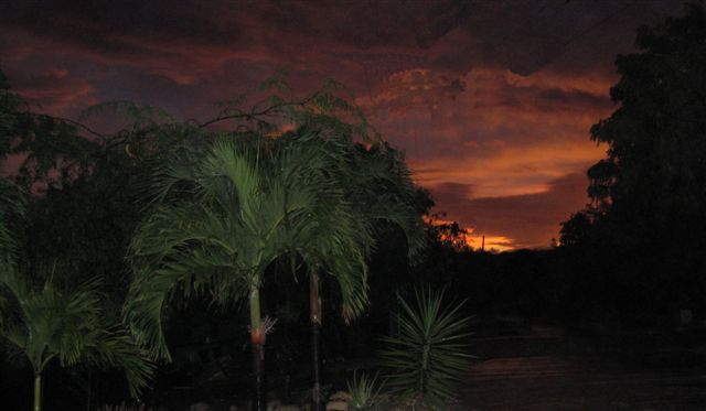
| - THAT ORANGE GLOW SUNSET | ||||||
| ||||||
Attachment:
IMG_1232.JPG |
| - all is calm |
|
It has stopped raining and we had a very beautiful yellow/orange
sunset glow about 45 minutes ago.
It is dead calm and a bit humid, the crickets and tree frogs are
chirping away.
Alan Scholl www.digitalphoto.ag |
| - JIZZLE |
|
|
Title: Message
JUST SPOKE TO MY
GOOD FRIEND MORRIS "TOMACK" NEDD ON BARBUDA. HE SAYS "JUST SOME JIZZLE AND A FEW
SHOWERS" AND THE WIND NOT VERY STRONG FROM THE WEST.
WIND HERE FROM THE
NORTH WEST 12-18 MPH.
TREE FROGS GOING
BANANAS.
|
| - Back ON THE ROCK | ||||||
| ||||||
|
| - Wind has shifted |
|
Over the past 10 minutes the wind has shifted and is
coming from the south west along with some rain. Nothing
significant in terms of speed but gusty.
Alan B Scholl www.digitalphoto.ag |
| - Grey and a little rain |
|
There was a shower a few minutes ago.The sky is overcast and there is a large grey wall north-east of my location in Clare Hall out past the airport. The Antigua Met Office (www.antiguamet.com) has predicted winds between 18-25 knots for Antigua and 25-36 knots for Barbuda. Time to get out the Melges for a hell of a run ;-) Alan B Scholl www.digitalphoto.ag |
| - Weather Conditions Starting to go Downhill |
|
It's getting a bit dark here in St. John's. I just got a report from a friend in the eastern section of the island that they are having thunder and strong winds. Rosie Rosie
Do you Yahoo!? Next-gen email? Have it all with the all-new Yahoo! Mail Beta. |
| - CHRIS |
|
|
ALL QUIET HERE.
SLIGHT BREEZE FROM NORTH-WEST.
THAT DON,T FRAID
WE.
|
| - hazy with clouds floating around |
|
So far it is a pretty nice day. There is a bit of haze and clouds floating by, with pacthes of blue sky. If you looked at the sat map of Messr CHRIS, one would expect a bit more here but we will wait and see. The atmosphere seemed to have coughed up this week. We have TS CHRIS in the ATL, Eight-E, TS Fabio and TS Prapiroon in the Pac. Alan B Scholl www.digitalphoto.ag |
| - CRISP | |
| |
|
| - FAT LADY | |
| |
|
| - overcast and high winds.. |
|
We have been experiencing gusty conditions 15-25knots maybe more. It is overcast but no rain in the north as yet. Alan B Scholl www.digitalphoto.ag |
| - REVVED | |
| |
|
| - blue skies with a bit of haze |
|
Another beautiful summer day although there was a heavy
shower this morning but just to wet the leaves.
It is going to be a scorcher.I see Madame BERYL is fluttering her skirt at the US east coast. Alan B Scholl www.digitalphoto.ag |
| - not ready yet |
|
|
Title: Message
a watched pot never
boils
|
| - Very hot |
|
A few scattered clouds about but it is a very hot day with blue sky and bright sunshine. Alan B Scholl www.digitalphoto.ag |
| - sun is back out but... |
|
The sun is once again shining brillianly but this morning at apprximately 5:40AM, we had some thunder and quite a bit of rain. I was still under the covers so I cannot comment on the lightning but the dogs were gong nuts and some thunder claps were quite loud rattling the louvres. Blue sky, white clouds and again, the sun is back out. Alan B Scholl www.digitalphoto.ag |
| - visibility back |
|
Visibility is back to the horizon but still very gray. Will keep you posted. Alan B Scholl www.digitalphoto.ag |
| - Gray and rain... |
|
For the past two days it has been raining off and on. I
was hoping with the passing of that weather system we
would see some sunshine today. It doesnt seem as if that
is going to happen this morning. The skies just opened up
and visibility is down to about 6 miles. I am hoping that
we will see a break later this afternoon. It always seems
to rain on the weekend and clear up just in time for work
on Monday :-(
Alan B Scholl www.digitalphoto.ag |
| - BLOWZ | |
| |
|
| - STORM CARIB'S 2006 DELUXE MODEL-ONE STOP SHOP | |
| |
|
| - ? |
|
|
Title: Message
VERY INTERESTINK
STUFF SWIRLING OUT EAST
|
| - Nice weather... |
|
Hi,Over the last few including the weekend we have had some lovely weather. Saturday was sunny, and went to a few beaches. Other than that, the occasional shower but lots of sunshine. Alan B Scholl www.digitalphoto.ag |
| - WAVE | |
| |
|
| - 2.7.06 | |
| |
|
| - Rain and overcast... |
|
Hi all,It is that time again! For the past two days it has been gray and overcast with some scattered showers. Last night, the heavens opened up around 8PM and it rained torrentially for about two hours in the St.Johns area. I haven't observed any rain this morning thus far but it is still gray and gloomy. Alan B Scholl www.digitalphoto.ag |
| - Fizzle and Drizzle |
|
Ever since the downpour early this morning, we haven't had much rain for the entire afternoon, just a few drizzles. The convections seems to be undergoing a minima towards nightfall(now that is). Maybe, hopefully, the Diurnal maximum should bring back a few bursts of showers and thunderstorms later tonight and early tomorrow, but the wave is moving away quite fast. The wind have also died down a bit, just about 10 knots now. A trade surge is however expected by tomorrow and some gusts can take place during showers. Seas moderate at 6ft now (a bit rough this morning). And...the Atlantic currently hold two healthy tropical waves. One near 36'W has a swirl to its cloud structure but not well organized, another wave was just introduced near 23'W with well defined structure. mmh..quite potent. _________________________________________________________________ Express yourself instantly with MSN Messenger! Download today it's FREE! http://messenger.msn.click-url.com/go/onm00200471ave/direct/01/ |
| - soupy |
|
|
Title: Message
cool breeze under
brer lion's nether parts.
nice showers, some
good gusts.
empty cisterns
replenished.
active out
east!!
anti-hurricane
fitness not to peak too early
boys in the back
getting scrubbed.
|
| - Rain, Rain, finally more rain |
|
We have had .48 inch of rain near St. John's between 12 midnight and 7 am this morning and is expecting more through out the day. Sad to say,these precious rain will be gone by tomorrow afternoon or night. Also, the weather was fairly stormy this morning with a few thunders, lightning and finally squalls. We had a 37 mph wind gust round 6:00 this morning and another 40 mph gust just came through a few minutes ago. It's beginning to look like the classic summer here while up in the north, Florida is bracing for their first storm of the season, Alberto. Well, it did surprise some forecasters by the burst of strenghtening yesterday to near hurricane force and it almost scared some residence shitless, but it's back to its usual self now. Will keep you updated, all the best. _________________________________________________________________ Express yourself instantly with MSN Messenger! Download today it's FREE! http://messenger.msn.click-url.com/go/onm00200471ave/direct/01/ |
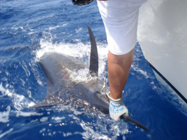
| - YESTERDAY |
|
GOOD FISHING YESTERDAY. SEA WAS CALM. HEAVY SHOWER IN THE NIGHT. WIND IS
UP TODAY.
MY PAL ALLAN RELEASED THIS FISH. TROPICAL WAVE COMING UP FROM THE SOUTH.

HOPE FOR MORE RAIN.
MANY MARLIN ABOUT.
Attachment:
Fishin 5 13 003.jpg |
| - Alberto |
|
Well...the first tropical storm of the season reveals itself rather in a tattered manner. A large part of the center(~75%) is literally cloud free! That dosen't sound to good for the system especially when the environment is getting more hostile by the hour. By the look of it, Alberto would not survive for long unless it becomes extra-tropical(its only option actually). And finally, Antigua is getting rain that we're waiting for the past couple of months, much needed rain which stopped as I type(only lasted for 15 minutes). But the sky remains cloudy, I just hope we will get more. The temperature has cooled down a lot since an hour ago currently 31 degree C. The sun is peeking out now, darn... _________________________________________________________________ Express yourself instantly with MSN Messenger! Download today it's FREE! http://messenger.msn.click-url.com/go/onm00200471ave/direct/01/ |
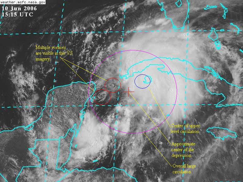
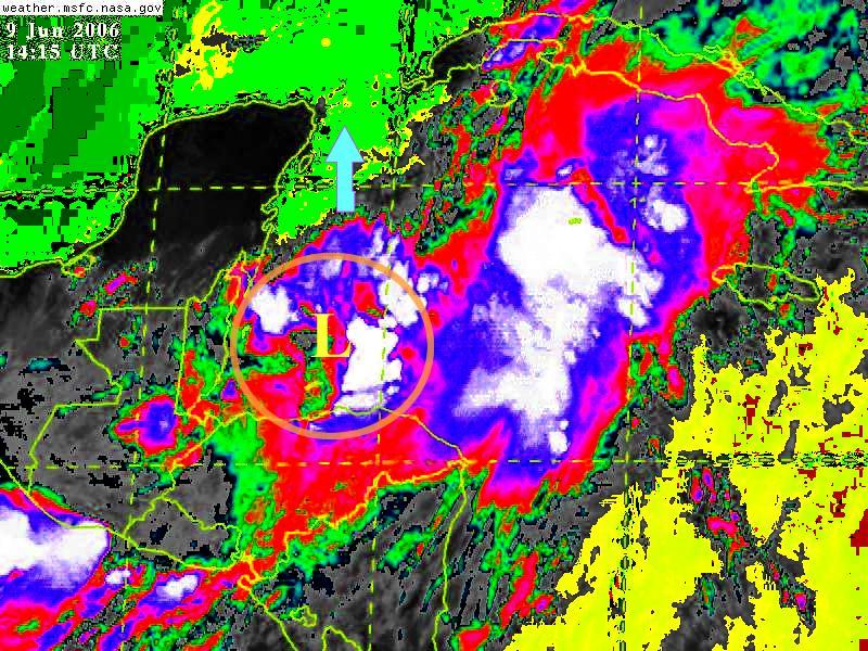
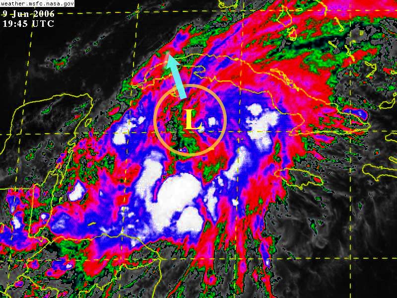
| - TD# 1 |
|
There's been only a slight change in appearance of the overall structure of the
low pressure system lastnight. Locating the center of the depression was
somewhat tricky last evening especially when I'm unable to secure an update of
the QuikScat data. The convection is a little bit more concentrated this
morning near the northeastern quadrant. But the majority of the center is void
of strong convection with strong winds confined mainly to the northern
semi-circle. Visible, Water Vapour images and QuikScat data allow for an easier
identification of the center this morning as shown in the images attached. The
first one is a standard IR with QuikScat analysis superimposed, you can see the
stronger winds(larger number of strokes on the main rod, the wind direction is
blowing towards the stroke free end of the rod.) to the northeast though some
data may be contaminated by rain. The depression is expected to strenghten into
a tropical storm(the first one for this season) later tonight or early tomorrow
morning before moving into the Gulf region where it may encounter some shear(up
to 25kts is possible). Then again, if it move more to the west rather than
recurving, it can encounter less shear. How I wish this storm is over us right
now. We really needed some lengthy rain spells in Antigua. Everywhere is so dry
down here! We haven't had some good rain for months!
_________________________________________________________________
Express yourself instantly with MSN Messenger! Download today it's FREE!
http://messenger.msn.click-url.com/go/onm00200471ave/direct/01/
Attachment:
TD01a01.JPG Attachment:
TD01a02.JPG |
| - DRY,ARID,PARCHED,WHATEVER. |
|
|
Title: Message
NO SIGNIFICANT RAIN
INNEARLY 5 MONTHS!! THE ISLAND IS BROWN. CAN'T WAIT FOR A
COUPLE OF GOOD STRONG TROPICAL WAVES TO GET
HERE. MORE
WATER RATIONING NOW THAN IN THE LAST 10 YEARS.
WILL NEED SALT WATER
SOAP FOR THE BOYS IN THE BACKROOM'S MID-YEAR BATH IF I CAN GET THEM THE 500 FEET
TO THE BEACH.
|
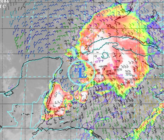
| - Tropical Depression #1 imminent...for now. |
|
Hey, it's probably gonna be the first tropical cyclone for the 2006 hurricane
season. A low pressure near the Cayman Islands is getting better organized as
it drift northward. It has all the signs of developing into a depression within
the next 12-24 hours. The two Convective Enhanced images taken at 8:00am and
4:00pm respectively are shown here. You can see the convective structure
starting to develop into a swirl and the cold cloud tops(white area) persists
through-out the day with bursts here and there. If a strong one develops over
the center, NHC is going to declare it a tropical cyclone. So far, sea surface
temperature remain warm in the area (the yellow and green regions in the first
image is actually an embedded thermal imagery of the sea surface temperature:
yellow- 29C, bright green- 28C, green- 27C and dark green- <27C.) and ahead of
the disturbance. Upper level wind shear is decreasing (currently about 5-10
knots) so it will favor the storm's development, but an area slightly ahead of
the disturbance remains high(20+ knots). If the system move into this area
before it slackens, it will affect the storm's development. Given the system's
current forward speed, there is a good chance it will develop into a depression
before moving through this area of shear. Well, that's another storm in June
just like last year. I wonder how this season's going to work out. Going for my
math book, all the best...
_________________________________________________________________
Express yourself instantly with MSN Messenger! Download today it's FREE!
http://messenger.msn.click-url.com/go/onm00200471ave/direct/01/
Attachment:
DevSTM02SST-IR.JPG Attachment:
DevSTM02bCE.JPG |
| - Lightning phenomena??? |
|
You have heard about cloud to ground and cloud to cloud lightning but have you
ever heard about cloud to space lightning...? Here is one seen on Jupiter!
_________________________________________________________________
Express yourself instantly with MSN Messenger! Download today it's FREE!
http://messenger.msn.click-url.com/go/onm00200471ave/direct/01/
Attachment:
jupiter-f1.jpg |
| - Hurricane season | ||||||
| ||||||
|
| - Hurricane Season 2006 |
|
Hey, happy Hurricane season! It's back again in the blink of an eye. Hopefully we will have a calmer season this year. Right now, all fronts are calm except for a little skirmish going on down south near Colombia. A low center has developed and is moving northwest out into open water. Nothing to worry about though. Upper level wind is not all too favorable at the moment. We'll keep you updated. _________________________________________________________________ It's the future, it's here, and it's free: Windows Live Mail beta http://www2.imagine-msn.com/minisites/mail/Default.aspx?locale=en-us |
| - Emailing: 79371516 at N00 |
|
  The marlin was caught by my son yesterday. Fought  2  more today for 1
1/2 hours each. Lost both.  Go to attached site.


The message is ready to be sent with the following file or link
attachments:

Shortcut to: http://www.flickr.com/photos/79371516 at N00/


Note: To protect against computer viruses, e-mail programs may prevent
sending or receiving certain types of file attachments.  Check your
e-mail security settings to determine how attachments are handled.
Attachment:
79371516 at N00.url |
| - MERRY MONTH OF MAY | |
| |
|
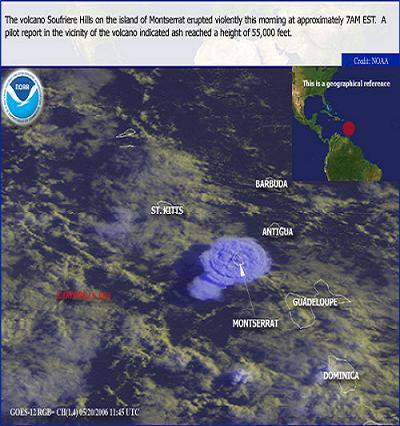
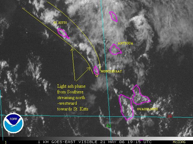
| - Montserrat Eruption |
|
|
Here are some SAT images from the eruption yesterday. The plume of ash cloud rising to 55000 ft was visible from Antigua. The first image was taken shortly after the dome collapse where the round top of the ash plume can be clearly seen. This was also visible on IR-images yesterday as an extremely intense cold cloud top at FL550 and lower level continuous emission at FL250-FL350. The second image was taken this morning showing continued emission of ash and gas moving northwest at near 30kt. Good thing the event is not a long lasting one. Enter the Windows Live Mail beta sweepstakes Upgrade today Attachment:
MONT20_052006VOL.JPG Attachment:
soufVolMONT.jpg |
| - MONTSERRAT VOLCANO | ||||||
| ||||||
|
| - STORMY! |
|
|
This afternoon suddenly turn dark-cloudy with a thunder cell rolling over northern section of Antigua. Just a few hours ago(5:00 PM LOCAL), we got multiple waterspouts forming just off the St. John's bay and Fort James vicinity. At least three of them were observed whirling towards the north-east. One of the waterspouts observed was at least 70 meters wide at the base and about 800 meters high connecting the sea to the cloud base in a majestic display. This one eventually stretched out into a long slanted thin line before breaking apart leaving a funnel cloud churning away. The entire outbreak lasted for about 45 minutes accompanied by relentless lightning and thunders finally capped by a heavy shower. Sorry guys, I would have posted some pics if I got my digital camera with me. It is a very interesting sight given that tornadoes and waterspouts rarely form this close to St. John's. Join the next generation of Hotmail and you could win the adventure of a lifetime Learn More. |
| - MAY 06 |
|
|
Title: Message
WONDERFUL WEATHER
FOR WEEKS NOW
CALM WINDS AND
SEAS,PERFECT FOR CAMPING ON BARBUDA OR, EVEN BETTER, FOR FISHING.HAD A
TREMENDOUS MAHI MAHI RUN THIS YEAR BUT IT SEEMS THAT ITS OVER
NOW.
YESTERDAY ONE WAHOO
55LBS AND A DOUBLE HEADER OF BLUE MARLIN-LOST THE LATTER 2 AFTER MUCH
TAILWALKING ETC....
TODAY ONE WAHOO
60LBS. WAHOO MEDALLIONS FOR DINNER!
SEA TEMP RANGED FROM
80.8 TO 81 DEGREES F.OUT IN THE FAR DEEP. WARMER INSHORE.
VERY LOCALIZED RAIN
ALBEIT HEAVY FROM HEAT CLOUDS.
READY FOR THE
SEASON??
|
| - broke back |
|
|
Title: Message
DON'T FIX WHAT'S NOT
BROKEN
|
| - ANTIGUA CLASSIC RACE EVENT | ||||||
| ||||||
|
| - !!!GREEEETINGS TO ALL!!! |
|
|
It's a very BLUE day in beautiful Antigua. There is the occasional calming breeze sweeping the face with a touch of cool tranquility. A few patches of cloud in the distance with a couple of short sharp showers is the entree for the day. It's good to know what Paradise felt like. I hope it is the same for our brethrens in the other islands.
Temperature is a bit warm here in the upper 80s. Somewhat similar to last year at this time in terms of temperature. Except for the breeze, not a good sign at all.
I could only give my best wishes to the other islanders and mainlanders in the region and hope that we are better prepared for whatever comes our way this time. Again, All the Best! See if you've won, play MSN Search and Win |
| Back to top |

 It is RAINY DAYS in Antigua just now! Some roads flooding making driving a bit tricky and our local "island ponds" which were dried up are now nearly full again! The island is very green due to all of the rain. But thank goodness no ill winds with the rain! Looks like we got through this hurricane season in good shape!
  Odd things these winds do.. But thank goodness FLORENCE blew away and seems the system behind her will do the same....
  Big blob off African coast but lets hope the projected path going north and away from ANYONE is correct. This is the time we really start watching the action with SEPTEMBER REMEMBER being so true. The rain showers we are getting off and on are always welcome.
  where we caught a couple of tropical waves that rocked our boat for 2 days! And now back to Antigua (the "rock).... With CHRIS on our doorstep bringing badly needed RAIN..
  With some thunder here on the East coast... Looking to the east it is VERY GRAY with heavy clouds out there. We are lucky, however, that Antigua and Barbuda only getting the edge of this as it moves north. Lets hope our neighbors to the north are as lucky. We do expect so gusty winds during the night but nothing to serious. This is a good drill for us to remember we need to be ready for "the real thing'!
  Please see: