
|
|
- Updates from the Islands -- - Aruba - - |
|
|
| - Rain, Rain, Rain |
|
|
Happy New Year 2006!! ,
It's the second day of the year, and already
rain is falling around the island.
MDNA&A Radar image is showing some rain clouds approaching the
islands, the rain shall begin tonight and will continue true the
morning tomorrow.
The skies are totally covered with clouds, and humidity is around 80% temperature is in the 25C, finally some rain since that very dry December!! 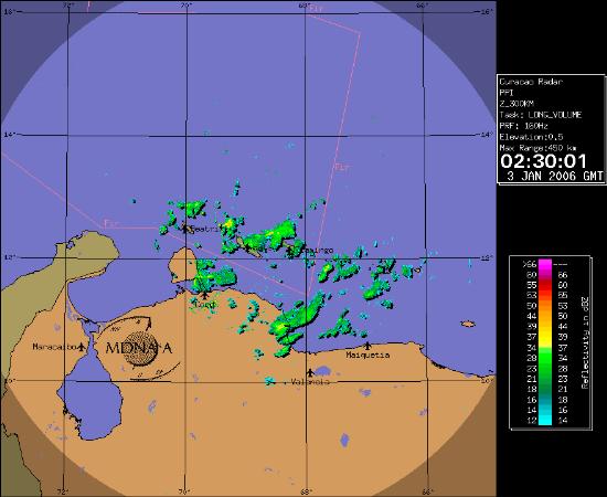
|
| - Brrrrrrrr |
|
It's "cold" right now here in Aruba, a Personal Weather Station at NOORD (www.arubawx.com) is reporting 20.1C as the lowest temperature of the day registered at 8:29pm, Right now at my house in Dakota the lowest was 23.2C, Dry air has spread around the Central Caribbean so the rain will go on a short vacation for now. Only the windward islands are expecting some rain on friday. In Aruba we can expect some light to moderate shower that's it for the week. |
| - Bonaire Update |
|
Right now Bonaire is still getting the rain as consequence of
T.D. 27 passing north of the ABC Islands as you can see on the BONAIRECAM
everybody is still inside and the beach is deserted. The radar shows the sky hasn't clear a bit over Bonaire from early morning , a personal
weather station on wunderground.com collaborates this scenario. Image: MDNA&A - http://www.weather.an/sat_img/radar2.asp   Image: By BonaireCAM - http://www.bonairewebcams.com/BonaireWebCams.php  Image: By BonaireCAM - http://www.bonairewebcams.com/BonaireWebCams.php  Image: By BonaireCAM - http://www.bonairewebcams.com/BonaireWebCams.php |
| - Rain Day |
|
Yep, like I said in my previous post about T.D. 27 heavy rain fell on
Aruba, although not as much as I expected, 51mm of rain from 6am to 8am
some roads according to METEO the heaviest was on the north section of
Aurba. The "Dam di Rooi Afo" was breached and roads were closed. The
Valero Gas station is still under water, Colegio Arubano a local High
School was flooded again and students got a RAIN DAY!!! Rain with
lightning and thunder began at 1am till 6am, followed by so medium rain
showers that lasted 2 hours, Traffic is pain in the neck right now, The
calamity prevention office and DOW are now in a meeting doing "Damage
Control" The forecast is rain, rain rain (by the way you can see that on the radar pic) The folks on CURACAO and BONAIRE received most of the rain accordingly to the MDNA&A Radar Image and Satellite Pictures of NOAA. I'll post again in the afternoon or sooner if something happens.
 Avenida Milio J. Croes (ex-Fergusonstraat) Image: Marko Espinoza  Cloudy sky on the horizon Image: Marko Espinoza  Colegio Arubano under water again........... Image: Marko Espinoza 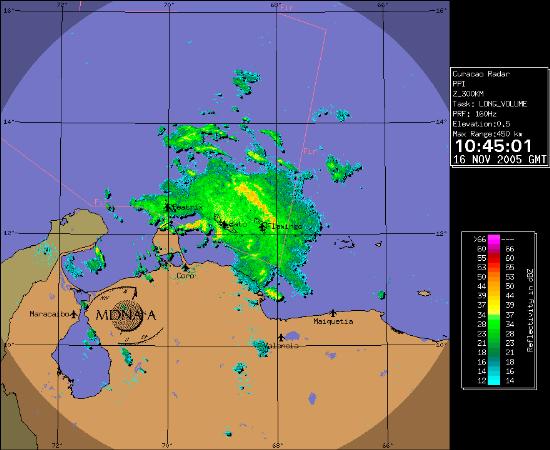 T.D. 27 is now clearly visible on radar, rain has started everywhere her in Aruba Image: MDNA&A - www.weather.an/sat_img/radar.asp  Vapor Image of T.D. 27 has it's convection to the south over Curacao Image: NOAA - www.ssd.noaa.gov/PS/TROP/trop-atl.html -- Marko A.J. Espinoza Cangahuala ------------------------------------------------------------------------------------- Chief Editor/Director Colarin Colegio Arubano colarin at colegioarubano.aw (297) 563-2099 - (297) 582-2005 Vondellaan 14, AW 50000 Oranjestad, Aruba www.colegioarubano.aw |
| - T.D. 27 Almost GONE! |
|
|
So, T.D. 27 has almost dissipated according to the latest NHC Advisory of course there is
still a heavy rain treat for the ABC Islands, but with a weak
depression that is a lot smaller. Right now in Aruba the skies are cloudy I see some Cumulonimbus Clouds and lightning on the far east of the horizon, Today not a lot of rain in Oranjestad, but it was very cloudy day indeed.On Monday in Curacao it rained more than on Aruba and Bonaire was dry like a desert. MAXIMUM SUSTAINED WINDS ARE NEAR 35 MPH... 55 KM/HR...WITH HIGHER  T.D. 27 is now clearly visible on radar. Image: MDNA&A - www.weather.an/sat_img/radar.asp  Vapor Image of T.D. 27 shows it's almost GONE! Image: NOAA - www.ssd.noaa.gov/PS/TROP/trop-atl.html -- Marko A.J. Espinoza Cangahuala ------------------------------------------------------------------------------------- Chief Editor/Director Colarin Colegio Arubano colarin at colegioarubano.aw (297) 563-2099 - (297) 582-2005 Vondellaan 14, AW 50000 Oranjestad, Aruba www.colegioarubano.aw |
| - To blue to be truth |
|
|
The latest Vapor Image is showing that the deepest convection
(Thunderstorms, Rain, Wind,) is located well south of Tropical
Depression 27. That's not a very good news for us here in the ABC-Islands, Aruba self is not prepared for a very heavy rain, the main roads will flood in a instant. Now the Latest Computer Models are good in agreement that it will pass a considerable distance of Aruba, but still the rain penitential is huge, and rain is the only thing needed to wreak havoc here in Aruba. The MDNA&A says that T.D. 27 is NOT a treat to the ABC-Islands, but still they are keep an eye just in case, on the radio there was not allot of comments or concern of T.D. 27 Right now everything is calm as an usual tropical night..... still I'm keeping my fingers crossed.....  The deepest convection is to the south of the storm that's not good for the ABC-Islands Image: NOAA  Some Street Flooding at Dakota Image: Marko Espinoza -- Marko A.J. Espinoza Cangahuala ------------------------------------------------------------------------------------- Chief Editor/Director Colarin Magazine colarin at colegioarubano.aw (297) 563-2099 - (297) 582-2005 Vondellaan 14, AW 50000 Oranjestad, Aruba www.colegioarubano.aw |
| - Here we go again......... |
|
Well, another tropical disturbance is menacing the Windward Islands
with heavy rain, gusty winds and possible landslides, the NHC is
keeping an eye on this disturbance. The satellite images early today
were spooky, but now the disturbance has lost some power. Some models
are taking this storm to the south, yep for the ABC Islands, and I
really don't like that!!! Today it has been quite a rainy day it started
at 4am and it's still raining right now, the cable when out of service
for 30 minutes, also some radio stations when out as thunder began to
rumble my windows. The sky is gray, the temperature is 25c, Everybody
is crazy about tonight's concert of Carlos Vives although the promoters
are saying the show will go on no mater what. While most of the
islanders will be dancing in the rain, I will stay home keeping an eye
on the tropical disturbance. Radar image form Curacao showing rain activity on Aruba and near Curacao Image from: www.meteo.an  Second run models are not optimistic for the ABC-Islands, but remember they can be WRONG! Image from: http://www.wunderground.com/  IR-Image of the region showing activity near ABC-Islands and the Tropical Disturbance near Barbados.  Vapor-Image of the region showing activity near ABC-Islands and the Tropical Disturbance near Barbados. |
| - Wet Sunday |
|
|
It's almost November and our raining season is knocking the door,
Heavy Rain Showers fell this afternoon for like 30 minutes in Aruba. I also heard thunder far far away no lightning, the weather will stay so until end December, heavy rain and then sun shine and vice-versa. In this active hurricane season we only had Hurricane Emily which passes 190km north of Aruba, only some localized flooding, but for the rest it was OK! We're still hopping that nothing more comes to our region, but recently, there is some activity brewing close to us, lots of tropical wave, causing rain and very dark skies, and at night illuminating lets hope they don't organize too much and become tropical cyclones.  Dark Clouds approaching Dakota - Marko Espinoza
 Dark Clouds approaching Sabana Blanco - Marko Espinoza
 Activity near Aruba - NASA
|
| - Bad weather by Alpha? |
|
|
It looks like a feeder band of alpha is creating some bad weather
around the ABC Islands no gusty winds, just thunder.... and as usual not much rain only a nice lightning display.  Lightning Detector Image By: drs. Marck Oduber  Rain Rate Radar Image By: MDNA&A |
| - Alpha? |
|
Interesting image of Dr. Jeff Masters Blog at wunderground.com >From the NOAA Atlantic Outlook A WESTWARD MOVING TROPICAL WAVE THAT HAS ENTERED THE EASTERN |
| - Thunderstorm |
|
|
It' flashing right now here in Aruba, I have lost powered must of my neighbors also, it's has been raining heavy for an hour right now. |
| - Bad Weather?! |
|
NHC finaly says something about the convection north of Aruba. |
| - What It This? |
|
There is an incredible amount of convection (thunderstorms) between
Aruba and Puerto Rico. |
| - October 5th Thunderstorm |
|
|
A "Noisy" Thunderstorm cause some loss of power in certain small
parts of the islands, but was not a heavy rain maker. but still it
remembered us all that the 2005 hurricane season is not over. The storm
was caused by a high altitude disturbance in the atmosphere that is
generating clouds to develop enhancing at the same time the chance of
rain or thunder near the island. Also 7 of 12 Radio Stations went out
of service for hours and the mail server of SETAR (Local Telecom
Company) was also down, unknown if the lightning cause damage or they
suffered a power failure.
|
| - Thunderstorm |
|
|
THUNDER HAS WAKEN UP EVERYBODY HERE IN ARUBA! I AM DOING MY BEST TO TAKE PICTURES OF THE STORM |
| - Tracking Information |
|
>From The NHC Tropical Discussion 8:05AM EST, 25 SEPT 2005 MiamiEAST CARIBBEAN TROPICAL WAVE HELD BACK ALONG 63W S OF 20N MOVINGIR- Loop ABC Islands Zoom http://wwwghcc.msfc.nasa.gov/cgi-bin/get-goes?satellite=GOES-E%20HURRICANE&lat=13&lon=-69&zoom=1&width=800&height=600&type=Animation&palette=spect.pal MDNA& Radars http://www.weather.an/sat_img/radar.asp http://www.weather.an/sat_img/radar2.asp Water Vapor Image http://www.ssd.noaa.gov/PS/TROP/DATA/RT/WATL/WV/20.jpg |
| - ArubaCAM |
|
|
Follow it Online with The ArubaCam at Bucuti Beach Resort - http://www.bucuticam.com/tarabeach.html |
| - Watching The Wave |
|
A Tropical Wave is nearing the ABC-Islands. The CUR-MET Radar indicates
moderate rainfall approaching .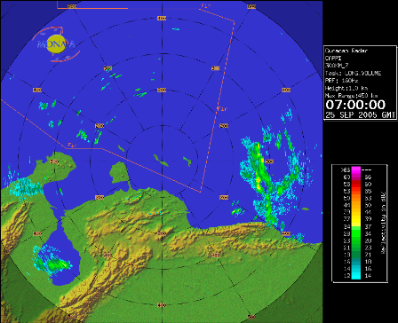
From MDNA& A - www.weather.an |
| - I wont miss you Philippe |
|
|
It looks that Tropical Storm Philippe will miss us totally, but we hope the best for St. Marten, St. Eustatius and Saba. We're almost approaching the letter "R" with that disturbance near Puerto Rico, are we going to pass the letter "W"??? I hope not.... |
| - Tropical Depression 17? |
|
|
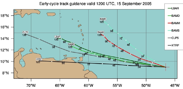
The Tropical Wave Close to the windward islands is getting more organized, some models have it going close to Trinidad other close to St Marten I will keep you posted of any news. Attachment:
earlyp1.jpg |
| - Hurricane Expo |
|
|
Lots of sun, some clouds from time to time if your here in Aruba you
may want to try The Hurricane Simulator at R.E. Irasquin and Sons made
by "Bibi Arends" of the Crisis Management Office of Aruba. Also visit
the expo which I helped putting in together for Mr. Arends some great
tips there! R.E. Irasquin is the local car dealer for Mitsubishi
located at L.G. Smith Blvd infront of the Aruban Port Authority. |
| - Bye Bye |
|
|
TD 9 has posses no longer a treat to the ABC-Islands, so bye bye TD9/Irene. |
| - Irene? |
|
|
T.D. Nine and maybe Irene in the coming days is now in the deep tropics
it's a little north of where Ivan and Emily formed. I'll keep track of
that storm as it continues to move westward as forecasted. |
| - Dust Storm Approaching |
|
|
Well, if you belief only rain can fall of the skies in this 2005
hurricane season think again!! A big "cloud" of Sahara dust is
approaching the Caribbean sea, we can expect a nice sunrise and sunset
today because particles will reflect more light causing the sun to be
more reddish. |
| - Final Report on Hurricane Emily |
|
|
It's more than 24 hours that Hurricane Emily moved north of us at a
distance of 190km. The official rain report indicates a total of 39.4mm
of rain, with Ivan it was a total of 250mm of rain. Some houses were
flooded for a small period of time, the damage was very low. Wind was
not a problem, there weren't a lot of trees down if any, The long
waited "Tale of Emily" (feeder bands) or in papiamento "Rabo di Horcan"
didn't reach us and did not cause anything but a light breeze in the
early morning. Please visit www.sciencearuba.com for a special report
of the passage of Hurricane Emily. Well it has been a very long week for me, I would like to thank all of those who reacted to my reports of Hurricane Emily. I wish the people who are in the path of the storm specially those in Jamaica and The Cayman Islands very good luck. I'm signing out for now, good luck to all the StormCarib reporters, Marko A.J. Espinoza Cangahuala |
| - It's over! |
|
|
Well it's now sunny and the effects of Emily are now over, the sky are clearing up by the minutes, there is now even sunshine. The Tropical Storm Warning was discontinued at 8am EST. People are waiting for the tale of the hurricane to hit us, but on the CUR-MET radar there is no "Tail" (Feederbands) Rainfall Reports are not available, still a Personal Weather Station reports 1.44 inches (30mm) of rain in Noord close to the Hotel Area. (Source: www.arubawx.com) Some houses were flooded according to a local radio station at San Nicolaas and Zeewijk that's located on the south eastern side of the island. |
| - Heavy Rain |
|
|
Heavy rains are reported around Aruba, some houses are flooded, Roads
in Yucuri, Zeewijk, Emanstraat, L.G. Smith Boulevard, Pos Chikito and
Savaneta are closed because they are now rivers.Until now it's has been
raining for 2:30 hours, There are periods of heavy rainfall and some
periods of normal rainfall i must say the rain is still less than what
we saw with Ivan.. The heavy rain is caused by outerbands in front of the Hurricane people here are worried because the "tale" of the Hurricane hasn't pass yet and that is usually the worst part, |
| - Hello Emily! |
|
|
The skies are now totally grey and CUR-MET Radar Images indicates that
the clouds are full of rain. thunder has now started as I'm writing
this report. |
| - Where is Emily? |
|
|
The sky is mostly cloudy, the air is kind of humid, there is almost no wind it's very very calm, everything looks normal. |
| - Clear Skies |
|
|
This afternoon we had clear skies comparing to what we saw in the
morning, winds were calm and it was a Little bit colder than yesterday. The waterspout was a false report, some people mistaken a low altitude passing clouds with funnel cloud according to drs. Marck Oduber. People here are really not in a hurry to prepare, I must say almost no one has prepared for this storm, The local calamity prevention office says it has started to give order to all EMS services to stand by. There is no plywood on the windows, there isn't any people buying desperately some batteries and can food. It is just a normal day here in Aruba. |
| - Waterspout? |
|
|
There are unconfirmed reports of waterspout touching ground near the local airport south east of Oranjestad. |
| - Outerband reaching Aruba |
|
|
Far west outerbands of hurricane Emily reaching Aruba right now, the
sky is getting darker by the hour, there is almost no wind and until
now no rain has fallen on Oranjestad, When Ivan pass it was a lot less
darker than now I must say, until now there has not been any press
conference of the government, only weather bulletins of the local Met.
Office or from the NOAA. |
| - Tropical Storm Warning |
|
|
Tropical Storm Warning is now in effect for the ABC-Islands. (7AM) On the latest satellite images of GOES-8 Emily hasn't move that much to the North the new position at 8am is 12.4N 62.9W at 5am it was 12.3N 62.3W |
| - West-northwestward |
|
|
The 5AM Advisory of NOAA about Hurricane Emily, says that the Hurricane
has started to move west-northwest, something very good for Aruba. This means that Aruba will receive less rain, and weaker Tropical Storm winds, still no official word if a Tropical Storm Warning will be issued. Now, this hurricane season was full of surprises, I hope that Emily doesn't bring a nasty one to us. |
| - Hurricane Lectures |
|
|
Want to learn more about Tropical Cyclones and how the Aruban government respond to these threats? Than take a look at the lectures of Aruba's weatherman drs. Marck Oduber and the director of Calamity Prevention Bibi Arends. Just go to www.sciencearuba.com for free videos and learn the truth of Tropical Cyclones passing close of Aruba. Keep track of breaking weather news for Aruba here at StormCarib.com and also on Sciencearuba.com |
| - EMILY IS NOW A HURRICANE! |
|
|
Tropical Storm Emily has developed into a Category 1 hurricane when passing north of Tobago. It is expected that tomorrow a Tropical Storm Warning will be issued for the ABC-Islands. As you may have read in the latest NOAA Advisory about Emily, The whole North coast of Venezuela is under Tropical Storm Warning. Local media reports that tomorrow around 5am a hurricane warning/watch may be issued by the local Met. Office - Just like what happened with Ivan. NOAA also forecast that 3 to 6 inches of rain may fall, tomorrow will be Judgement day for Aruba. Let's hope it passes a little bit North from us. |
| - Tropical Storm Watch for The ABC-Islands |
|
|
At 5pm a Tropical Storm Watch has been issue for the ABC-Islands (Aruba, Bonair, Curacao) by MDNA&A The Local Met. Office If conditions continue to be the same, A Tropical Storm Warning will be issued tomorrow, it's predicted to pass Aruba 180KM on Friday morning as a Category One Hurricane. All the local radios are now sending a special bulletin, a radio stations calls Emily "Hurricane Ivan Part II" The Weather is the typical Caribbean Weather, lot's of sun and some light breeze. Aruba has got some direct hits of Weak Tropical Storms, Emily is a Severe Tropical Storm, the possibility of a direct hit cannot be ruled out according to Aruba's only meteorologist yet. |
| - Where is the wind again! |
|
|
Woke this morning to cloudy skies and a light drizzle- looked at the map and I hope this does not develop. The good news- when the winds are this light, the snorkeling is perfect!
Amy Express yourself instantly with MSN Messenger! MSN Messenger Download today it's FREE! |
| - Update |
|
|
Well not even June 1 and the weather is very strange. This is the second day in a row with thunder, grey skies and variable light wind. I hope this is not an indications of what is to follow this year. So far no real rain to speak of- just enough to make the roads slippery.
I hope those of you who are getting more rain are ok and don't have too many problems. Let's hope Adrian dies out soon.
Take care
Amy Express yourself instantly with MSN Messenger! MSN Messenger Download today it's FREE! |
| Back to top |


