
|
|
- Updates from the Islands -- - St.Thomas (USVI) - - |
|
|
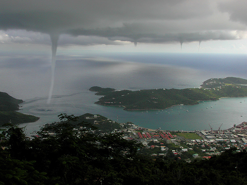
| - Fwd: Fw: Waterspouts in St Thomas Harbor -REALLY |
|
I said wow, too!
|
| - waterspouts on st thomas usvi |
|
hello all
 yesterday oct25 2000
  waterspouts reported on sw end
of st thomas near the airport...cold
air trough interacting with easterly flow
causing thunderstorms and lighting,
watersprouts are very rare seabourne tornados
see attachment
today is lovely 86 pc
visit martha in antugia to see her birds
and nice shots of the island
http://www.huckphotovi.com
huck


theglobe.com
  Your friendly full-service integrated online community.
  http://www.theglobe.com
|
| - Confounding! |
|
|
Good evening! Joyce has decided to be a virtual
no-show in the Northern Caribbean which is great news. She also has apparently
decided to give Trinidada and Tobago something they haven't had in a long time:
Any tropical storm! I have two friends who just moved there recently and they
were laughing when they left St. Thomas saying "We don't get storms there!"
Well, usually, they are right but the law of averages does average out once in a
while!
Joyce has been subject to low-level shearing which
has been hard to detect previously. She has confounded and bewildered even
the most experienced meteorologist's, most computer models, and amateurs
like myself! She does help prove that we cannot usually accurately
predict 3 days and beyond as the environment is constantly changing.
Meanwhile, a large wave is coming off the
African coast and appears very interesting already. Also, Hurricane
Keith is making headlines as he churns near the Yucatan peninsula of Mexico
and threatens Belize also. The memories of Mitch are still fresh in that area of
the Caribbean as Keith is moving very slowly dumping huge amounts of rain
not needed in such a short period of time and over mountainous
terrain.
Here, the US Virgin islands has partially cloudy
skies with high humidity (76%) and very little wind. Pillsbury Sound (between
St. Thomas and St. John) is glass-like; which only happens 6-8 times a
year. Thunderheads abound but are sporadic. A quiet evening for the US
Virgin Islands! Fortunately, I haven't had to board up further
and can enjoy this evening!
Dave
|
| - Joyce |
|
|
Good morning to all. Unfortunately, I believe it
will not be a good morning on Tuesday or Wednesday next week as Joyce appears to
be making a "Scary Movie" appearance of her own. Still hard to forecast as she
just isn't following conventional hurricane forecasting, but then again, I've
warned about that before.
I still forecast her to make her Marilynesque turn
just below Barbados!
FEMA (Federal Emergency Management Agency) already
has their Emergency Response Team-Advance in the territory which adds
significance to the threat of Joyce. I'm reasonably sure they believe a direct
hit is very possible. Again though, nothing is concrete at this
time.
The local paper (Daily News) has been running daily
articles concerning Isaac and Joyce. By the way, Isaac did reach Cat 4 status!
Happy it went far north of the islands. It's impact would have been devastating.
Joyce will be no slouch but her relative compactness should help minimize any
damage unless significant strengthening occurs. VITEMA is already active in
hurricane preparations and a few long gas lines were noticed
yesterday. Several grocery stores were also very active. The marine
community is taking Joyce very seriously and has already started their hurricane
plans. I will be active myself on Saturday.
Since TD 15's emergence, Joyce seems to have taken
a backseat in regards to the islands coverage as it is closer to the mainland US
and hence, more of a "potential threat". It's hard to see the satellite photo's
of Joyce when the forecaster's are standing in front of it! Hopefully, I
can help to change that soon locally.
Currently it's overcast and very humid (85%). It's
raining on St. John and more is forecast for St. Croix and St. Thomas as well.
Winds are very calm at the moment as is the ocean but both are supposed to pick
up later in the day.
Dave
|
| - Shall we be in St. Kitts? |
|
|
Well, our
birthday/anniversary trip is to St. Kitts.....leaving tomorrow.
Hmmm. I didn't invite Joyce to my party. We'll see if we get to stay
until Monday as originally planned......
Linda Robinson Barr |
| - Joyce |
|
|
Good morning! I sure hope Gert and the GFDL model
are correct in their long-range analysis of Joyce. The farther south Joyce stays
on her westerly trek before turning greatly increases the chances of a direct
hit somewhere in the NE Caribbean. The trough above and ahead of Joyce is
keeping her from turning more northwestward at tthis time and the SW shear,
which was ahead at about 52W is very weak, if there at all now. Joyce did take a
slight NW jog overnight but that could temporary. On the other hand, it is still
too far away to accurately forecast the path Joyce will take and proposed
strength. Joyce does need to be taken seriously by anyone living in the islands
as Joyce has the potential to take a "Marilynesque" turn 4-5 days down the road.
Currently, the skies are overcast and the US Virgin
Islands are under a flash flood watch until 6:00 pm AST as the wave which passed
yesterday is kicking up alot of convection with heavy downpours and some
thunderstorms. We do need the rain but not all at once as the groundsoil is not
very deep and cannot handle 2-3 inches in an hour. Major runoff would occur and
street flooding would be nightmarish. A little at a time.
Dave
|
| - Issac/Joyce |
|
|
Goodbye Isaac. Hello Joyce! Isaac is impressive but
has fortunately climbed more to the north; thus bringing a big sigh of relief.
On the other hand, TS Joyce brings much concern. Having formed much lower than
Isaac, she has much better potential of creating havoc here in the NE Caribbean
and the Central Caribbean as well. Joyce should develop slower as Isaac has
taken alot of energy from the ocean and atmosphere in that area but as Isaac
pulls away to the north, Joyce will have her way. I believe everyone from
Guadeloupe north should pay extra attention to this storm.
Since Joyce is so far out east, it is very hard to
even semi-accurately predict 7-10 days in advance. This should not preclude
anyone from dismissing the potential severity of this storm though. A cautious
eye should always be cast east this time of year!
Tonights weather has been rainy for a change with
lot's of lightning and thunder. Great because we need the rain. Bad because it
knocked out cable for awhile (Monday Night Football)!!
The local paper (The Daily News) has been running
steady 1/8 of a page arcticles on the previous few tropical waves/developing
storms. However, they appear to be about 12-18 hours behind by the time they go
to press. A 5 pm report should not make the next day's newspaper as events can
change rapidly. Overall though, they have been doing a much more credible job
this year as opposed to the last few in keeping up with current and running
weather situations. The local radio stations are a different matter. The same
forecast is heard on several stations for up to 6 hour periods and this is very
misleading. To their credit, they have been speaking about specific coordinates
of storms; something that hasn't happened before.
Dave
|
| - Isaac |
|
|
As I discussed in my earlier report today, Isaac
has the "potential" to become a major hurricane; possibly affecting the NE
Caribbean within 6-8 days. Unlikely is a good possibility; however,
the threat is still very real, even if 1870 miles away from the
fringe islands of the Northern Antilles (Antigua, St. Maarten, Anguilla, etc...)
and further west, the British and US Virgin Islands. As we have seen and
experienced before, not every storm follows projections. And it is hard to
forecast something of this possible magnitude so far away from here.
More reliable information will become available in
the next few days; still giving enough warning if the storm threat does
materialize!
Dave
|
| - Isaac |
|
This report is coming via Hotmail as I am not at home. Tropical Storm Isaac has rapidly burst upon the scene as our first "classic Cape Verde" storm of the 2000 season. As we well know, the storms which form here are usually formidable and dangerous so a wary eye must be cast on Isaac as it makes it's trek across the Atlantic during the next 7-10 days towards the Caribbean. Computer models predict a steady WNW track and further strengthening for the next three days. If a ridge forms to the north at this point and the SW shearing environment which has been "protecting" us lessens, conditions would be ripe for a powerful Hurricane Isaac to move in a more westerly direction thus elevating the danger level to the NE Caribbean. However, it is still too early to accurately forecast past the next three days. Isaac has alot of ground to cover. Directly ahead of Isaac is a very small area of dry air visible on water vapor imagery which would temporarily inhibit Isaac's growth. Sea surface temperatures are slightly lower where Isaac is than they are a little farther south. If Isaac reaches approx. 40W-42W and stays on a more westerly course, this storm has the potential to reach Cat. 4 status. Again, still early yet. But don't go ignore the potential either! superdave AT islands.vi _________________________________________________________________________ Get Your Private, Free E-mail from MSN Hotmail at http://www.hotmail.com. Share information about yourself, create your own public profile at http://profiles.msn.com. |
| - TD 12? |
|
|
Boy, it has been a while which is good! TD# 12 has
dissipated into a strong tropical wave which means squally winds and rain for
most of us in the Northern Leeward Islands. Rain, at this point, is a good thing
as we have been semi-parched for quite some time. Debby has been the only
significant "rainmaker" in the last few months. Makes great business for the
water-tanker owners!
The SW shear has been the Caribbean's protector
this hurricane season. Same as with TD# 12. Now, just a strong tropical wave. I
believe it will re-generate after it passes the Virgin Islands as conditions are
way more favorable to the west of here. There are a few more waves coming across
which bear attention, especially due to the time of season.
The GDFL model and one other predicted Gordon to
become a hurricane and slam into Central Florida within 48-72 hours yesterday.
This computer model has been slow to the task and often maligned but correct in
this instance! This shows you cannot discount anything when trying to predict
Mother Nature.
The tropical season has been somewhat good and
quiet to the Northern Leeward Islands this year; so far. Again, no
alarmiscism but stay prepared regardless!
Dave
|
| - TD12...HELENE??? |
|
WELL HERE WE GO AGAIN... HAD GREAT MEAL AT LATTITUDE 18.ALEX'S FOOD IS GREAT,MUSIC WAS GREAT, SHIRIN PLEAE SEND SDS PHOTO AGAIN NOW FOR MORE SERIOUS STUFF THIS DEPRESSION LOOKS LIKE TROUBLE ALL FORCASTS SHOW IT MOVING SOUTH OF ST CROIX TD12...SOON TO BE HELENE....WE ARE ALL ON OUR TOES ANY JOG TO THE NORTH AND WE ARE IN TROUBLE JUST A DEPRESSION AS OF NOW...WATCH CLOSELY YESTERDAY WAS FIVE YEARS SINCE MARILYN!!! NOW FOR THE UPDATE...... AT 5 AM AST...THE METEOROLOGICAL SERVICE OF ANTIGUA HAS ISSUED A TROPICAL STORM WATCH FOR ANTIGUA...ANGUILLA...BARBUDA... MONTSERRAT...NEVIS...AND ST. KITTS. A TROPICAL STORM WATCH REMAINS IN EFFECT FOR ST. MAARTEN...SABA...AND ST. EUSTATIUS. TROPICAL STORM WARNINGS MAY BE REQUIRED FOR PORTIONS OF THE LEEWARD ISLANDS LATER TODAY. TROPICAL DEPRESSION CENTER LOCATED NEAR 16.0N 55.1W AT 16/0900Z POSITION ACCURATE WITHIN 60 NM PRESENT MOVEMENT TOWARD THE WEST OR 280 DEGREES AT 10 KT ESTIMATED MINIMUM CENTRAL PRESSURE 1009 MB MAX SUSTAINED WINDS 30 KT WITH GUSTS TO 40 KT. http://www.huckphotovi.com/hurricane99.html http://www.huckphotovi.com GOOD LUCK ALL...GOD SPEED! HUCK _________________________________________________________________________ Get Your Private, Free E-mail from MSN Hotmail at http://www.hotmail.com. Share information about yourself, create your own public profile at http://profiles.msn.com. |
| - Ernesto |
|
|
TS Ernesto appears to pose no threat to any of the
Caribbean Islands. The SW shear has, again, protected us from immediate harm and
Ernesto will eventually die out in the Central Atlantic unless conditions
rapidly become more favorable.
A low associated with a wave along 26W-27W is in a
fairly favorable area at 10N but will take it's time to develop, if at all, due
to it's low proximity. It's this same proximity, however, which bears the wary
eye as the historical "high" season is almost upon us.
Dave
|
| - ERENSTO |
|
HELLO AGAIN
THIS ONE LOOKS LIKE IT WILL PASS NORTH...ACCORDING TO NAVAL OPERATIONS...NOAA HAS IT STILL LISTED AS TD8...
GUESS ITS TAKES TIME TO UPDATE! BEAUTIFUL MORNING OUT
STILL AND PARTLY CLOUDY.MULTICOLORED CLOUDS AT SUNRISE
ERNESTO SHOULD PASS US....WATCHING LOW PRESSURE AREA
FOLLOWING..
NEW SITE ADDRESS
http://www.huckphotovi.com
old address still works
http://members.theglobe.com/huckphotovi
huck
ps
this gert and super dave on st thomas just before debbie


theglobe.com
  Your friendly full-service integrated online community.
  http://www.theglobe.com
|
| - Looking East! |
|
|
It's that time of season where we look with wary
eye's towards the East and Southeast. Right now, there is a strong wave approx.
850 miles ESE of the northern Leeward islands which has potential for
development. However, the southwesterly shear environment it will move into will
inhibit significant strengthening and also pull it to the NW. It still bodes
watching though.
There is a low at approx. 8N25W which, over time,
could prove interesting. Now is not the time to become complacent because it has
been relatively quiet. Awareness is a good thing.
Dave
|
| - Slowly heating up?? |
|
|
Not much out there since the "excitement" of
Hurricane Debby. The east bears watching though as we are entering the most
active tropical system time period historically speaking. Right now, there is a
1012 low at 11N26W although possible development will be slow. There is a huge
wave, satellite imagery-wise, coming off the coast at the moment and a few
smaller one's behind it. As in last year, the bulk of the activity will manifest
itself within the next 6-8 weeks.
The weather here has been peaceful. We still could
use alot more gentle rain though!
Dave
|
| - Quiet on the Caribbean Front! |
|
|
Fortunately, Debby has degenerated into a strong
wave and the likelihood of her regenerating isn't that promising. However, she
must still not be discounted until she moves over solid land and falls apart or
disintegrates over open water.
Nothing of real mention looking towards the east;
just a few minor waves with no real convection to speak of which is welcome
news, especially at this time of year! Let's all keep our fingers crossed (and
toes) and hope the shearing environment stays in place! Cable and power finally
back to normal as far as I have seen. Quiet, hazy night this eve. Great to be
back to normal!
Dave
|
| - Bye Debby! |
|
|
The remnants of Debby passed by last night and more
rain and wind came from that than the eye itself. Putting the house back
together today as most Virgin Islanders are and counting our blessings. I must
say though, the shuttering that went up on Monday will not come down from this
house until mid-November! only damage was to some landscaping and minimal at
that. To the residents of St. Croix, it appeared to be just a another day
with some clouds and minimal rain. Officially, St. Thomas picked up about
1.93 inches of rain which really isn't much here. We needed it bad anyway;
we just didn't need a hurricane attached to it. Bye Debby!
TS Alberto is finally dying and headed
towards, of all places, Iceland! Something doesn't seem right when a tropical
system winds up in Iceland But then, I guess I can't seem to think of a better
area for it to go: the cold North Atlantic!
Not much else is on the horizon looking towards the
African coast. A mid-way wave has a 1012 low along 16W40N but definitely
unimpressive. A larger wave is just off the coast but no deep convection or
organization which is good. We are coming into the "active" time of the
hurricane season so we should be aware and not let Debonair Debby to lull us
asleep.
There are several large waves in Western and
Central Africa which will merit attention once they make it to the coast like
the one I mentioned in a report back on August 10th which eventually turned into
Debby.
Thanks to all who send there e-mails as your
questions and comments make this all worthwhile.
Dave
|
| - Debby's tail! |
|
|
After a relatively quiet afternoon, even as the eye
passed, the evening has been more active. Several thunderstorms have made their
way through and the rain I was wishing for came down hard uncovering a leak or
two in the house. We have had gusts over 50 mph again this evening and the wind
is still whipping along. Very humid and visibility is about 4-5 miles. From the
Doppler radar, it appears we will get more of the same as Debby exits the area.
Curfew has been lifted and nothing unusual to report except a fire (auto?) down
by Sapphire Beach. Police and fire trucks are on the scene.
The islands in the way of Debby must prepare
quickly as she appears to be gaining strength and covers a large area. We dodged
a docile Debby here but she is going to be a mean lady coming your
way.
Dave
|
| - WOBBLY ...DEBBY... THANK THE LORD |
|
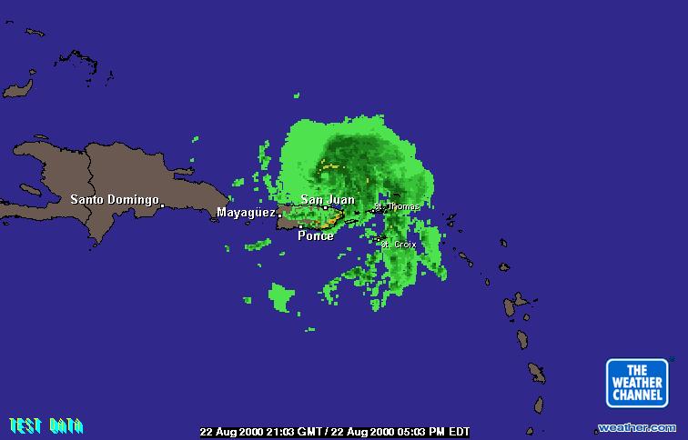
WOW THE RAINS HAVE FINALLY STARTED...INTENSE PELTING RAIN,LIGHTING THUNDER FROM THE RAIN BANDS FOLLOWING ATTACHED IS SAN JUAN RADAR PIC WORSE THAN DURNING THE STORM HUCK ST THOMAS |
| - She's passed now! |
|
Seems Debby has passed now. Sure some rain may come, but looking for clear skies! Here are some more pics. Ronnie in St. Thomas |
| - Debby |
|
All utilities are still on here on the east end. The wind has picked up a bit (or maybe shifted so that my condo isn't shielded from it), but very little rain. No damage that I am aware of. |
| - Debby |
|
All utilities are still on here on the east end. The wind has picked up a bit (or maybe shifted so that my condo isn't shielded from it), but very little rain. No damage that I am aware of. |
| - ITS HERE...DEBS BLOWING NOW |
|
HELLO ALL JUST CAME FROM OUTSIDE...REALLY BLOWING NOW MAYBE 45MPH. STILL NO RAIN REALLY JUST DRIZZLE,BUT STINGING. WINDS FROM THE SW...3-5FT WAVES AT MORNINGSTAR BEACH.POWER STILL ON BUT NORTHSIDE OUT; FEEDER 7 MANDAHL PEAK AREA.STILL HAVE DOORS OPEN, ALL THREE OF THEM BECAUSE WINDOWS BOARDED.REPORTS SAY CENTER IS WOBBLING,CAT IS IN MY LAP;SHE LIKE TO BE THERE WHEN I AM ON LINE...I THINK SHE LIKES THE MOUSE... WIND IS HOWLING. THE PELICANS AND GULLS ARE STILL ABOUT.CURFEW STILL IN EFFECT! MUST SIGN OFF TO GO PICK UP GAIL FROM THE REEF,I'LL BE BREAKING THE LAW.... NO BIG DEAL ONLY 1/2 MILE. CORDS 18.5N 64.4W 1:45PM 8/22/00 HUCK HTTP://WWW.HUCKPHOTOVI.COM |
| - Quiet Debby |
|
|
Debby is passing by here with not much in the way
of rain or winds which is great except we could use some rain! We had a very
short period of 50 mph + wind gusts but that was about it. The wind has turned
around now so the eye has made it's pass.
Our first heavy rain, on the east end of the
island, was about 11:05 am with power already having been out for approx. 3
minutes. Very little wind at that time and visibility was 2-3 miles at best. A
heavy, yet narrow band of rain went through about 12:00 pm along with the first
gust higher than 38 mph. No high winds were really sustained for any period of
time though. Very erratic.
Power has dropped a total of three times but has
been restored quite quickly for a storm situation. The phone lines, at least out
here, have never gone out. No rain at this time; just some minor wind gusts.
Time to let the dogs out of the house so they can return to the yard!
The Turks and Caico's and the Bahama's should watch
this storm closely as it is time for her rapid intensification to start I
believe. We were lucky as we have been in regards to previous storms of mention;
Georges and Lenny. Now is not the time to let our guard down as we have 6-8
weeks of deep season left.
Dave
|
| - picture - pictures |
|
Hey fellows, here is another link to follow up if you like to see Debbie up close and personal through doppler images but in animated mode (last four hours). Updated by the hour it gives you the doppler image just east of Anegada to just east of DomRep. http://www.wx.com/nbr/ssanim.cfm?radar=JUA Or you can try this next link for a slightly different doppler shot that is updated a little more frequently and covers just about the same area with no animation. http://www.intellicast.com/LocalWeather/World/Caribbean/PuertoRic o/SanJuan/BaseReflectivity/ Hope everyone comes out OK! Best Wishes from San Juan...-= Luis =- =-=-=-=-=-=-=-=-=-=-=-=-=-=-=-=-=-=-=-=-=-=-=-=-=- Christian Motorcyclists Association - Puerto Rico http://www.cmausa.com =-=-=-=-=-=-=-=-=-=-=-=-=-=-=-=-=-=-=-=-=-=-=-=-=- |
| - Eye |
|
|
Title: Eye
Got the eye...nice and calm and now the power goes out. Go figure -- Max R. Schanfarfer http://www.virtualstthomas.com |
| - Some more shots |
|
Here are two more pics. The wind is coming from the west. TWC says she is now north of us. Haven't closed my last door yet! Doesn't look like I may have to. Hope not! Ronnie in St. Thomas |
| - Where's Debby...? |
|
For being out only 40 miles it's still quite. I'll leave the color commentary to Big Dave. -- Max R. Schanfarber http://www.virtualstthomas.com |
| - Where's Debby...? |
|
For being out only 40 miles it's still quite. I'll leave the color commentary to Big Dave. -- Max R. Schanfarber http://www.virtualstthomas.com |
| - Some pics |
|
Here are some pictures of Debby so far. I suppose since she is moving so fast that she will be here and hit and run! No prelim's just hurricane! Since it is 11 am and no sign other thaan these pics. Ronnie |
| - WOW...DEBBY??? |
|
HELLO FROM ST THOMAS I BEEN MONITORING THE WEATHER SINCE 5 AM.. LITTLE NEW AS OF YET GUSTS HAVES JUST PICKED UP,SOME RAIN BANDS???,SHOWERS MOSTLY. WENT OUT TWICE THIS MORNING NO ONE AROUND...STREETS EMPTY.. CURFEW IN EFFECT...LOTS OF DISSCUSSION ON RADIO ABOUT THIS... EVEN OUR GOVERNOR QUITE CALM NOW. SAN JUAN RADAR SHOWS HEAVY RAIN ON TORTOLA. STAY TUNED FOR MORE http://www.huckphotovi.com huck jordan beverely hills west st thomas |
| - Not much! |
|
|
I thought we were supposed to have a hurricane! All
boarded up and nowhere to go. Debby has veered more northerly and as a result,
we haven't seen anything but a few gusts to 28 mph and virtually no rain. Lots
of haze and I have seen some rain over by Tortola and even St. John but nothing
but sprinkles here on the east end. We are the dry end of the island anyway! I'm
sure everyone is happy the storm is not going to have a significant impact.
Still, we should experience some higher wind conditions and a few good feeder
bands within the next 4-6 hours. As fast as she is going, conditions should
improve rapidly.
No reports of any damage at this time. Electricity
is still on as is phone service. I haven't slept yet so I'll be cat-napping
through the day. Happy birthday to bikinibeach in St. Maarten! Funny, I had
Lenny on my birthday last year!
Puerto Rico looks in pretty good shape also. Down
the road though, the mainland should start making some preliminary preparations.
This could be a monster when and if it reaches.
Dave
|
| - Well she's near! |
|
Some wind looking to pick up, a light drizzle crossed the harbor. As far as my calculations, it should still be noon. Still judging from those satellites we should be under fire, but not. Took some pictures but it looks like a regular beautiful day in the Virgins! Ronnie in St. Thomas |
| - Debbie not here yet! |
|
It's 5 am, after the two o'clock advisory I figured she was at 330 miles out or approx. 11 hours. This would mean the eyes arrival at 1 PM Tuesday. Now at 5 am she's approximately 140 miles out or 7 hours away which would mean Noon. Which will it be? It's hardly blowing here in the town area although on the satellite image it appears that we should be in the thick of things! Always baffles me, what we see on the satellite Vs what's outside! Wish it was bright enough to take a picture, another hour maybe. Ronnie in St. Thomas |
| - Debby Goes Hurricane As It Nears Antigua and Barbuda |
|
|
| - Waiting for Debby |
|
Sounds like a movie, but here we sit waiting, understanding she should be here by morning. This is the part that kills, a lose lose situation, you wait and hate it, when it finally arrives you really don't want it, when gone you're happy for a short while until you have to deal with the after effects. Right now, there are a few small gusts, and some sprinkles of rain. Boring enough to take a nap until it picks up! Will update as we progress, if I can. Ronnie |
| - Debby |
|
|
8 millibars! That was some drop in
pressure over a three hour period! However, the wind speed did not increase
and the forward speed dropped a little. That part is not good. Satellite photo's
are looking more impressive as time progresses.
St. Thomas is under curfew as of 12:00 am until
whenever the Governor lifts it. If the storm passes quickly and damage is
minimal, it could be lifted as early as Wednesday afternoon. Unfortunately, I'm
not of the opinion we'll get off that easy. We currently have an 83% chance the
center of Debby will pass within 65 nautical miles today. St. Croix has an 84%
chance. If it stays a bit south, we will get the Northern and Eastern
quadrants. Not good at all. If it goes a bit north, we'll be alot better off.
Either way, it will be close!
Power is still on and there was a period of uneasy
calmness for the last half-hour. Even the 1/2 moon came out and some stars but
the wind has picked back up. Will send periodic reports until power goes
out. Until then, good luck to all!
Dave
|
| - debby |
|
hello all... st thomas updatesat 11pm 17.2N 61.0W breezy with a few rain bands about 10pm nhc report follows...000 WTNT42 KNHC 220235 TCDAT2 TROPICAL STORM DEBBY DISCUSSION NUMBER 10 NATIONAL WEATHER SERVICE MIAMI FL 11 PM EDT MON AUG 21 2000 CORRECTION...INITIAL WIND SPEED IS 60 KNOTS THE CENTER IS RELOCATED NORTHWARD BASED ON RADAR IMAGES FROM GUADELOUPE AND ON A RECENT AIR FORCE RECON FIX. EXCEPT FOR SHIFTING THE FIRST 24 HOURS OF THE FORECAST TRACK NORTHWARD BY ABOUT 30 N MI...THERE IS LITTLE CHANGE TO THE FORECAST TRACK FROM THE PREVIOUS ADVISORY. A RIDGE TO THE NORTH OF THE STORM IS EXPECTED TO CONTINUE TO FORCE A WEST-NORTHWESTWARD MOTION THROUGH 72 HOURS AND THE GFDL...UKMET...GFDL RUN OFF OF NOGAPS...AVN AND FSU EXPERIMENTAL ALL SHOW THIS. ONLY THE UKMET HINTS AT A TURN TOWARD THE NORTH AND THIS IS AFTER 72 HOURS. RECON REPORTS THAT THE SURFACE PRESSURE DROPPED 8 MB IN A COUPLE OF HOURS TO 996 MB. THIS AND WHAT LOOKS LIKE A NORTHERN HALF OF AN EYE WALL FEATURE ON THE GUADELOUPE RADAR ARE THE FIRST SIGNS THAT DEBBIE MAY ACTUALLY BECOME A HURRICANE. THE INTENSITY FORECAST IS SIMILAR TO THE PREVIOUS ADVISORY BRINGING THE WIND SPEED TO 75 KNOTS IN 24 HOURS. FORECASTER LAWRENCE stay updated at http://www.huckphotovi.com good luck all huck jordan |
| - DEBBY... |
|
HELLO ALL... 11PM REPORT FROM ST THOMAS . BREEZY WITH SOME RAIN BANDS ON THE SOUTH SIDE ABOVE MORNINGSTAR BEACH.PRETTY QUIET NOW,SERIOUS DOWNPOUR DURING HALF TIME MONDAY NITE FOOTBALL 10PM.NEW UP DATE BELOW... WTNT42 KNHC 220235 TCDAT2 TROPICAL STORM DEBBY DISCUSSION NUMBER 10 NATIONAL WEATHER SERVICE MIAMI FL 11 PM EDT MON AUG 21 2000 CORRECTION...INITIAL WIND SPEED IS 60 KNOTS THE CENTER IS RELOCATED NORTHWARD BASED ON RADAR IMAGES FROM GUADELOUPE AND ON A RECENT AIR FORCE RECON FIX. EXCEPT FOR SHIFTING THE FIRST 24 HOURS OF THE FORECAST TRACK NORTHWARD BY ABOUT 30 N MI...THERE IS LITTLE CHANGE TO THE FORECAST TRACK FROM THE PREVIOUS ADVISORY. A RIDGE TO THE NORTH OF THE STORM IS EXPECTED TO CONTINUE TO FORCE A WEST-NORTHWESTWARD MOTION THROUGH 72 HOURS AND THE GFDL...UKMET...GFDL RUN OFF OF NOGAPS...AVN AND FSU EXPERIMENTAL ALL SHOW THIS. ONLY THE UKMET HINTS AT A TURN TOWARD THE NORTH AND THIS IS AFTER 72 HOURS. RECON REPORTS THAT THE SURFACE PRESSURE DROPPED 8 MB IN A COUPLE OF HOURS TO 996 MB. THIS AND WHAT LOOKS LIKE A NORTHERN HALF OF AN EYE WALL FEATURE ON THE GUADELOUPE RADAR ARE THE FIRST SIGNS THAT DEBBIE MAY ACTUALLY BECOME A HURRICANE. THE INTENSITY FORECAST IS SIMILAR TO THE PREVIOUS ADVISORY BRINGING THE WIND SPEED TO 75 KNOTS IN 24 HOURS. FORECASTER LAWRENCE HOPE EVERY ONE STAYS SAFE,WE ARE BOARDED AND READY??? http://www.huckphotovi.com huck jordan |
| - Debby |
|
This is superdave AT islands.vi but I am sending this from the road;hence hotmail account. The Coast Guard has closed the port of St. Thomas effective 8:00 am tomorrow am as hurricane warnings have been posted. This means there will be no cruise ship visits here until this coming Sunday at least. Debby has increased her forward speed and is on a more westerly heading and the eye is projected, at this time, to pass just south of St. Croix. This means however, the northern qaudrants will affect all of the Virgin Islands. With her intensity also picking up, this will not be a pretty picture. The winds will be higher over the mountainous areas (where I live!. I will be home today by 3:00 pm to finish my preparations. The only good thing about her forward speed is she'll be gone in a hurry instead of traveling 10 mph and pounding us as she goes by. Traffic is heavy. I observed long lines at the gas stations and the supermarkets. I was at the lumber yard at 7:15 am and not much concern was shown then. But it is now. Curfew will be in effect, probably by 12:00 pm. Then, it's a waiting game. Dave ________________________________________________________________________ Get Your Private, Free E-mail from MSN Hotmail at http://www.hotmail.com |
| - DEBBY |
|
|
GOOD MORNING ALL
HANG ON TO YOUR HATS THIS ONE IS DANGEROUS ALTHOUGHT IT MAY
ONLY BE A CAT 1 HURRICANE. IT LOOKS LIKE A DIRECT HIT ON THE VIRGIN
ISLANDS...BE PREPARED, WATER,BATTERIES, FOOD ETC
MORNING CORDINATES VARY NHC HAS HER AT 15.6N 54.7W AT 5
AM
NAVAL OPERATIONS PUTS HER AT 15.4N 53.9W
YOU CAN STAY UPDATED AT
IT IS 7 AM NOW AN A BEAUTIFUL DAY ALTHOUGH A BIT
BREZZY
MESSAGE TO GERT HOPE YOU WILL BE OK SEND MAIL WHEN YOU ARIVE
IN ST MARTIN
HUCK
ST
HTOMAS
|
| - Debby |
|
|
Not a good time for my mail server to have
problems! A hurricane watch has been posted for many of the NE islands including
Puert Rico. This is a large storm and could further develop down the line into a
massive one after it leaves the Caribbean. Not good news there. The wave behind
Debby has calmed down a bit so our attention is focused on hurricane
preparedness. So far, it appears Debby will be a storm like Hurricane Bertha was
in 1996. However, we have seen them intensify rapidly before and, especially in
St. Thomas, we have experienced the destruction a so-called "Category 1" system
can wreak. Bad memories there.
The weather right now is pretty fair with breezy
conditions. Expect to get first heavy dose of rain late tonight. I will be
finishing up my preparations this evening as I expect a curfew to be instituted
no later than 3:00 pm tomorrow if Debby maintains her track and intensification.
Yesterday, there was a good amount of people in hardware and retail stores
getting supplies and with the hurricane watch being posted, today and tonight
will probably be zooey! Cruise ship cancellations have started already and will
post those tonight. Good luck to all.
Dave
|
| - Debby |
|
|
It appears Gert may be in for an up-close and
personal experience with a hurricane while he is on vacation! TD# 7, at this
time, is forecast to turn into Hurricane Debby within 72 hours and be virtually
right on top of the BVI's and St. Thomas at the end of that forecast period. As
one of the forecasters noted however, 72 hour projections can have errors of up
to several hundred miles. Let's hope the several hundred miles is to
the north!
Little activity was noted yesterday among the
people of the island but, with a probable hurricane watch being issued later
today for portions of the NE islands, it will start to pick up, especially
at the gas stations, supermarkets, and lumber yards.
Dave
|
| - TD #7 |
|
|
Goodbye Alberto! Still alive and kicking but due to
finally meet his demise over cooler waters in the next 3-5 days. Goodbye Chris
for the time being. Now, we have TD #7, soon to be TS Debby. Current projections
take it south of St. Croix although this would station the US Virgin Islands in
the strongest quadrants of the storm. Some models forecast it to be hurricane
strength within 48 hours and the others, just below. Dry air ahead should slow
it's intensification but after it passes that narrow area, it should pick up
rapidly. Either way, the NE Caribbean should take this threat seriously. Chris
was just a reminder of the time of season. This storm, I believe, is for real.
No sense of urgency yet here in St. Thomas. I feel
the populace will not take any intense action until tomorrow evening or Monday
morning. Hopefully, this will not have to be.
Dave
|
| - Chris |
|
|
Hurricane Alberto is still kicking with no
potential threat to any land masses for the time being although the Azores might
be getting a little gun-shy. Tropical Storm Chris is developing slowly and the
center of circulation is ill-defined. The computer projections still take it to
the north of the Leeward Islands regardless although a little farther south than
24 hours ago. Intensification can be rapid as evidenced by an earlier storm
which rose from depression to hurricane status in just 6 hours!
Interests in the NE Caribbean should be monitoring
Chris as the center could positively form farther south or east than anticipated
which would require Tropical storm watches and warnings to be posted. The
anticipated weather conditions would include squally rain showers with potential
flash flooding. If Chris follows the earlier projections though, a few rain
showers will be about all this area would receive.
Further east, a wave with a 1012 mb low at approx.
10N37W is worthy of careful watching due to it's low lattitude, neutral weather
conditions for development, and the time of hurricane season. This one could be
interesting. Let's hope not.
Dave
|
| - TD #6 |
|
|
The oldest tropical storm of August since 1900
(Alberto) and the newest tropical depression of the year 2000 (TD
#6) are the topics of interest at this time. Alberto is projected to
loop himself and finally become extratropical by late next week. A virtual
month-long tropical system!
TD #6 is now looming ever closer to the Lesser
Antilles. Projections take it a couple of hundred miles north of the NE
Caribbean Islands (BVI's and the USVI) with only some rain and
thunderstorms possible. However, according to the latest discussions, it IS
possible the NE Caribbean Islands could experience tropical storm force winds
and rain if the ridge north of here is stronger than believed which would force
(soon to be tropical storm Chris) in our
westerly direction. All interests in the NE Caribbean should monitor this
developing storm.
Dave
|
| - Alberto and East |
|
|
Wow! Alberto appears to want to live forever! Now
the third longest-living cyclone in the month of August since 1900! And still
not finished yet! Fortunately, he is not near or threatening any land masses.
Again, the unpredictability of tropical systems manifests itself with
Alberto!
The tropical wave stretching along 43W is getting
it's act together albeit slowly. We need to pay close attention to this one and
the wave along 25W which is the wave I spoke about earlier in the week.
Tonight is a beautiful night here in St. Thomas and
has been enjoyed by all! If only they all could be this complacent!
Dave
|
| - Super evening! |
|
|
All is quiet on the Eastern Caribbean front.
Tonight is one of the clearest and driest evenings we've had in a long time. A
virtual full moon, 10-15 kt. winds from the NE, and a dry, no-haze atmosphere
are the ingredients for a comfortable evening, both visually and
atmospherically.
Again though, the height of the hurricane season is
approaching and we must keep a wary eye open and not be lulled to sleep by it's
early inactivity. An evening like this, however, makes it very easy to
temporarily forget.
Dave
|
| - Heating Season |
|
|
We, in the NE Caribbean, are happy to say goodbye
for good to Hurricane Alberto after an interesting week, both locally and
meteorologically. A relatively, for this time of year, calm period is forecast
for the next 4-5 days here in the US Virgin Islands. However, a weak low has
developed at approx. 12N26W but appears insignificant at this time. No deep
convection is apparent on satellite imagery but the areas ahead of this wave/low
are favorable for future development. If this wave stays on it's current
course, things could get interesting next week. Right now though, I am
looking with great interest at the possible wave which will be the third in
line to come off the African coast within the next 3-6 day if it
survives the trek.
Today, we had .49 inches of rain in a one hour span
which is badly needed. Many people are buying water (Approx. $300.00 for
5,200 gallons) as our rainfall for the last few months has been dismal.
However, the islands appear to be more interested in the possible sale of
the local electrical company (WAPA) to Southern Energy, Inc. than anything in
the tropical arena, beneficial or otherwise!
Alberto has left the scene; I hope this doesn't put
the populace into hibernation.
Dave
|
| - Alberto |
|
|
Alberto continues to beguile the hurricane forecast
model computers at this time as well as us amateurs! It appears Alberto will
pass, at least for now, closer to the NE Caribbean than previously calculated as
the trough to the north didn't pick the storm up as projected. Although vastly
improved, hurricane forecasting has, and will continue to have, it's
unpredictable moments. Again, "Back-Door Lenny" from last November comes to
mind.
The local paper (The Daily News) had a small
headline on the front page of yesterdays edition but buried the story on page
11. The VI Emergency Management Agency did not mobilize over the weekend
but were tracking Alberto's progress. No lines for supplies were evident
although a closer than predicted path will probably scare some into
picking them up.
Dave
|
| - Alberto |
|
|
Well Alberto, if anything, has raised the awareness
levels here in the Virgin Islands. More concern was shown yesterday by the
general public. At that time, it did look like Alberto would take a more
westerly course. Now it appears it will veer to the northwest and miss us
completely. Right now, we have light rain as the lower portion of a split
tropical wave is passing over us. I'm somewhat dissappointed here so far as I
expected alot more rain from this system.
The sinister looking wave from yesterday which had
just came off the coast of Africa no longer looks impressive. I believe Alberto
took what atmospheric energy there was at this time of year for itself leaving
cooler waters and drier air.
Dave
|
| - alberto |
|
|
well here we are again
looks like we might be out of the woods on this one or
on the beach...
still maintaining my pages
weather can be found at
dot com is soon to come just waiting on nic
tropical storm formation expected on system just north
of us
according to naval ops 18.5n 64.8w wont affect
us
will be on line main page updated
also
huck
beverely hills
st
thomas usvi
|
| - Alberto |
|
|
Once again, Alberto appears to be moving a little
farther north than predicted which is good news for the Virgin Islands. Most of
the official discussions and models see it the same way although after 48 hours,
there seems to be some disagreement. We could definitely use some rain but not a
hurricane! Yesterday, I checked my generator's readiness, filled up the truck
and jeep with gas, as well as several gas cans. Also checked battery supplies
and ordered 2 propane tanks to be delivered Monday.
St. John discussed it's readiness in the paper
yesterday. They appear to have all of their ducks in a row. I hope so as they
are more isolated after a storm than St. Thomas or St. Croix as there is no
airport and are treated stepchildish already.
A sinister looking wave is poised to exit the
African coast soon. It's that time when we start really paying attention to
these, even is SST's are still a little cool and the coast is so far away.
Closer to home, we have a disturbance close by to the ENE expecting to bring us
some heavy rain after midnight tonight and tomorrow. Definitely could use
it.
A new site was sent to me this morning concerning
the weather here in the NE Caribbean. It's address is www.stormvi.com and is maintained by a local.
An excellent needed addition, especially for locals.
Dave
|
| - Alberto |
|
|
Alberto already is an interesting beginning to the
2000 named storm season. It appears the computer models vary widely, especially
in 3-6 day projections. If the ridge weakens to the north, then Alberto will
move more WNW and probably eventually curve North. If the ridge remains in place
and some other air weaknesses are shored up, we will see a more direct Westerly
track. This is somewhat disturbing for us here in the NE Caribbean. This would
put Alberto roughly passing under the Virgin islands but not by much and leaving
little room for damaging fluctuations.
Still, it is early yet. No real mention of the
storm by the populace here. There was intense interest from the boating
community and I know of two boats leaving today just in case. After all of the
storm action we have had here since 1995, some of us are gunshy. But it is still
better to be safe than sorry later.
As I do yearly, I wonder how much coverage the USVI
will get from The Weather Channel in the event a storm gets dangerously close.
As I said before, this is what alot of residents rely on as well as radio.
Dave
|
| - Calm before the storm |
|
|
It's still early as far as an active tropical
season (Atlantic) is concerned but do not allow yourselves to be lulled to
sleep. The conditions these last 6-8 weeks have been more of a spring-type
climatology in the tropics, Caribbean, and the Eastern Seaboard than a typical
summer climatology. A very large patch of dry, sinking air has really helped to
inhibit tropical formation as well as westerly shear; unusual at this time of
year. However, as the most active (traditionally) part of the season draws near,
contentment should not enter any part of the Caribbean as well as the East
Coast.
Here in St. Thomas, US Virgin Islands, there has
been a copious amount of media coverage in the last few weeks dedicated to
hurricane preparation and survival. Seminars have been held, meetings among
government agencies, etc...By the same token, Hurricane Supplication Day,
(Monday past) was very lightly observed by the populace; probably because it's
not one of the many VI Government holidays anymore due to budget constraints. A
Danish holiday first observed in the early 1700's to pray to be
spared from storms, it has lost alot of it's significance among the new
generations. Most used the holiday as a normal 3-day weekend in past years. Not
what it was for! On a brighter note, even FEMA has contributed extremely
helpful information and tips as well as providing monetary assistance to help
bring a few of our public schools up to code; not only for a possible hurricane
strike but an eventual earthquake as well. Yes, we live in a zone 4 earthquake
zone also; the same classification as San
Francisco, CA as I'm aware of. I have personally felt 6 tremors in the last 10
1/2 years. A magnitude quake of 6.8 or higher occurring close by will cause
extreme damage here due to undercode hillside building and poor construction.
Not to mention the possible accompanying tsunami.
Let's keep our fingers crossed for all that
Mother Nature has to offer. While beautiful, do not underestimate
her!
Dave
|
| - TD #2 |
|
|
Well, TD #2 has supposedly hidden itself in the
ITCZ but I believe, based on all current information that I have read, it will
regenerate itself. Hopefully not though. The last few years tropical
developments have put the most experienced meteorologists and the NHC back to
school in certain instances as the weather has not been as "patternable" as in
past decades.
Page 6 of our local newspaper, "The Daily News",
has two hurricane related articles today. No mention of TD #2 anywhere in the
articles or on the weather page (14). A media oversight at the least, even if it
is still 3-4 days away.
Dave
|
| - TD #2 |
|
|
Another storm season is upon us and who is making a
far eastern Atlantic appearance but TD #2. Sea surface temperatures are marginal
at best across it's track until, if it stays together, it reaches a couple
hundred miles east of the Lesser Antilles. Assuming that is marginal also but,
at that time, it could be a Category 1 or 2 after reaching that area. The
current track is also subject to conjecture after the next four days but I'm not
real happy as this started way south and has no steering currents as yet to take
it anywhere but west or slightly west/northwest.
Other than the VI Government (Vitema) and Federal
officials, there are not many residents of St. Thomas who would be ready until
the last minute, if then, for such an early season storm. Our local emergency
management team has held several seminars on hurricane preparedness already and
have declared themselves ready if the need arises. A very positive note compared
to previous years! Also, with our recent history of hurricane "hits or near
hits" (Marilyn, Bertha, Georges, and "wrong-way Lenny" to name a few), this
territory is in a much better state of prepareness. Building codes have been
strengthened, agreements with the marine industry and the Department of Planning
and Natural Resources for safe-havens have been agreed upon for boaters, our
government is better organized (in this area), and Federal officials have
unceasingly been promoting hurricane awareness.
Unfortunately, our local population doesn't
take hurricane season seriously until August or September. Hopefully, this early
TD #2 will wake them up as never before.
Dave
|
| - hurr???not now |
|
hi well i guess its time to up date... http://members.theglobe.com/huckphotovi caribbean news hurricane2000 huck from stt theglobe.com Your friendly full-service integrated online community. http://www.theglobe.com |
| Back to top |

