
|
For the most recent reports from St.Maarten/St.Martin see this page.
- - - 2009 Hurricane Season - - -
|
- SxmGIS - Pet owners and animal lovers asked to consider the safety of pets this hurricane season
|
- From: Roddy Heyliger <roddyheyliger at yahoo.com>
- Date: Wed, 9 Sep 2009 14:26:29 -0700 (PDT)
|
News Release
Written by Roddy Heyliger, Government Information Service (GIS), Ennia Bldg., Longwall Rd., Philipsburg, St. Maarten D.W.I. Tel. 00-599-543-1162, 542-4119, Fax: 543-1169; Email: gis at sintmaarten.net;
For Immediate Release: Wednesday, September 09, 2009/N160
Pet owners and animal lovers asked to consider the safety of pets this hurricane season
GREAT BAY, St. Maarten (GIS) – The third major storm of the hurricane season, category three Hurricane Fred, is currently churning out in the Atlantic Ocean approximately 2000 miles from St. Maarten. Hurricane Fred, the sixth storm of the season does not pose any threat to land. At the same time, it is a reminder that we should not let our guard down.
The Office of Disaster Management & Preparedness is asking animal owners and pet lovers to consider the safety of their pets and to draft a plan to protect them in the event of a hurricane strike.
This appeal is in line with the Office of Disaster Management & Preparedness’s 2009 hurricane season theme, ‘It Only Takes One.’
Animals are barred from hurricane shelters. Therefore, pet owners should consider the risk to animals during disasters. When a hurricane threatens, pet owners should select a room in their home – never leave a pet outside during the storm, definitely not on a chain. If you cannot bring them indoors, secure them in another safe place such as a concrete garage.
Include your pet in your emergency food supply kit. Have at least one week of canned food and/or dry food. Be sure to store enough water for your pet/s. If your pet needs medication, be sure to have enough medications on hand and stored in a waterproof container. You should also include tick-flea medication and anti-heartworm tablets.
Always keep an identification tag on your pet, even those that are kept indoors. Pets may get lost and the ID tag will assist in finding the owner and returning your pet to you.
If you have to leave your home, arrange a safe place for your pets to stay prior to a hurricane strike. Have a leash and/or a portable carrier (big enough for your pet to stand up and turn around) on hand to move your pet from one location to the next.
For further information regarding pet and animal safety during times of disaster, you can contact Animals R Friends or one of the Veterinary Clinics.
The hurricane season runs from June 1 through November 30.
# # #
Roddy Heyliger
St. Maarten Government Information Service (GIS)
Roddy Heyliger
MedPRO - Communications & Public Relations
Cell: 00 599 5204217, 5816323 (Voice Mail)
Email: roddyheyliger at gmail.com
MedPRO - Designed to broaden public knowledge by informing.
__________________________________________________
Do You Yahoo!?
Tired of spam? Yahoo! Mail has the best spam protection around
http://mail.yahoo.com News Release
Written by Roddy Heyliger, Government Information Service (GIS), Ennia Bldg.,
Longwall Rd., Philipsburg, St. Maarten D.W.I. Tel. 00-599-543-1162, 542-4119,
Fax: 543-1169; Email: gis at sintmaarten.net;
For Immediate Release: Wednesday, September 09, 2009/N160
Pet owners and animal lovers asked to consider the safety of pets this
hurricane season
GREAT BAY, St. Maarten (GIS) ? The third major storm of the hurricane season,
category three Hurricane Fred, is currently churning out in the Atlantic Ocean
approximately 2000 miles from St. Maarten. Hurricane Fred, the sixth storm of
the season does not pose any threat to land. At the same time, it is a
reminder that we should not let our guard down.
The Office of Disaster Management & Preparedness is asking animal owners and
pet lovers to consider the safety of their pets and to draft a plan to protect
them in the event of a hurricane strike.
This appeal is in line with the Office of Disaster Management & Preparedness?s
2009 hurricane season theme, ?It Only Takes One.?
Animals are barred from hurricane shelters. Therefore, pet owners should
consider the risk to animals during disasters. When a hurricane threatens, pet
owners should select a room in their home ? never leave a pet outside during
the storm, definitely not on a chain. If you cannot bring them indoors, secure
them in another safe place such as a concrete garage.
Include your pet in your emergency food supply kit. Have at least one week of
canned food and/or dry food. Be sure to store enough water for your pet/s. If
your pet needs medication, be sure to have enough medications on hand and
stored in a waterproof container. You should also include tick-flea medication
and anti-heartworm tablets.
Always keep an identification tag on your pet, even those that are kept
indoors. Pets may get lost and the ID tag will assist in finding the owner and
returning your pet to you.
If you have to leave your home, arrange a safe place for your pets to stay
prior to a hurricane strike. Have a leash and/or a portable carrier (big
enough for your pet to stand up and turn around) on hand to move your pet from
one location to the next.
For further information regarding pet and animal safety during times of
disaster, you can contact Animals R Friends or one of the Veterinary Clinics.
The hurricane season runs from June 1 through November 30.
# # #
Roddy Heyliger
St. Maarten Government Information Service (GIS)
|
|
- Mixture of sunshine and a few showers...
|
- From: Roddy Heyliger <roddyheyliger at gmail.com>
- Date: Sun, 6 Sep 2009 20:11:01 -0400
|
Today (Sunday – 20.12): The weekend has been a mixture of sunshine and a few showers. Last Friday we experienced the type of weather from Erika which we had expected on Thursday. Erika was an erratic and slow moving system and hence why a day late in receiving her rains etc which were very much welcomed.
Sunday has been cloudy and humid. It was a great day for the beach as the sea swells have subsided and things are back to normal.
The mozzies are up and about.
Best regards, Roddy Heyliger P.O.Box 945, Philipsburg, St. Maarten Cell: 5204217-primary, 5816323-secondary Public Relations & Communications Secondary Email: roddyheyliger at yahoo.com
CONFIDENTIALITY NOTICE This e-mail message is intended only for the individual(s) to whom it is addressed. This e-mail may contain information that is privileged, confidential and exempt from disclosure under applicable law. If you are not
the intended recipient, you are hereby notified that any dissemination, distribution or copying of this communication is strictly prohibited. If you received this e-mail by accident, please notify the sender immediately and destroy this e-mail and all copies of it.
|
|
- Update
|
- From: "Barbara Cannegieter" <barcann at hotmail.com>
- Date: Fri, 4 Sep 2009 13:39:20 -0400
|
|
We waited for rain from Erika all day yesterday
and got almost nothing.
Now that there is no more Erika, we get
the rain.
It has been raining on and off all morning on
St. Maarten.
I'm not complaining. We need the rain!
Another good day to stay home and read a
book!
Have a good weekend
everyone!
|
|
|
- SxmGIS - Governor Commends Community for Attentiveness during the Passing of Tropical Storm Erika; Erika downgraded to Tropical Depression; TS Warning Discontinued
|
- From: Roddy Heyliger <roddyheyliger at yahoo.com>
- Date: Thu, 3 Sep 2009 17:07:49 -0700 (PDT)
|
News Release
Written by Roddy Heyliger, Government Information Service (GIS), Ennia Bldg., Longwall Rd., Philipsburg, St. Maarten D.W.I. Tel. 00-599-543-1162, 542-4119, Fax: 543-1169; Email: gis at sintmaarten.net;
For Immediate Release: Thursday, September 03 2009/N155 Advisory #5 – 8.00pm
Tropical Storm Warning Lifted as Erika weakens to a Tropical Depression; Governor Richards thanks populace for attentiveness during the passing of TS Erika
GREAT BAY, St. Maarten (GIS) – Chairman of the Emergency Operations Center (EOC) Governor Franklyn Richards would like to commend residents for being attentive to weather reports and official information that was released during the passing of Tropical Storm Erika.
At 5.00pm a tropical storm warning was lifted for St. Maarten as Erika has weakened to a Tropical Depression. The Netherlands Antilles & Aruba Weather Service has also discontinued the Small Craft warning but maintains a Small Craft Advisory for local waters until further notice.
The anticipated rain and winds from Tropical Storm Erika did not materialize even though the system passed approximately 80 miles South of St. Maarten on Thursday. Weather systems change suddenly and what is forecasted and anticipated at times doesn’t actually take place.
Governor Franklyn Richards ordered all schools closed Thursday as a precautionary measure due to the anticipated change in weather conditions. Normal school activities are to resume on Friday.
“It is better to be prepared than to be sorry. I am pleased with the actions and attentiveness of the community before and during the passing of Tropical Storm Erika. Once again for this season we have been lucky, and therefore it is very important that the populace continue to maintain a state of readiness in case we face another storm/hurricane threat.
“Our actions taken as an EOC were appropriate and well measured against the available information from the weather experts. Other islands in the North Eastern Caribbean took similar actions such as the closure of schools. There were also some disruption to flight schedules and some businesses remained closed. In Antigua & Barbuda, the emergency management coordinators opened hurricane shelters in four different communities.
“I would like to thank the Emergency Support Functions (ESFs) of our disaster management system, who did an exceptional job in making sure that national preparations were at a state of readiness for any eventuality.
“The populace can rest assure that this type of readiness will be maintained during the rest of the season by the ESFs, and it is also expected that residents maintain a similar readiness. Remember the theme of the Office of Disaster Management & Preparedness that ‘it only takes one,’ Governor Richards told the Government Information Service (GIS) on Thursday.
For official weather information during the hurricane season, check out the Netherlands Antilles & Aruba Weather Service website: www.meteo.an
# # #
Roddy Heyliger
St. Maarten Government Information Service (GIS)
Roddy Heyliger
MedPRO - Communications & Public Relations
Cell: 00 599 5204217, 5816323 (Voice Mail)
Email: roddyheyliger at gmail.com
MedPRO - Designed to broaden public knowledge by informing.
Attachment:
SxmGIS NRelease TS Erika Downgraded to Tropical Depression Gov Thanks Community & ESFs Advisory 5 030909.txt
Description: Binary data
|
|
- Update
|
- From: "Barbara Cannegieter" <barcann at hotmail.com>
- Date: Thu, 3 Sep 2009 15:11:46 -0400
|
|
Conditions are still quiet in St. Maarten.
It is extremely humid and very
calm.
It looks like weather is starting to come in
from the South but nothing much has really reached land
yet.
|
|
|
- Overcast...and not much signs of Erika around....
|
- From: Roddy Heyliger <roddyheyliger at gmail.com>
- Date: Thu, 3 Sep 2009 12:20:47 -0400
|
Today (Thursday - 12.25): nothing much has changed since this morning. It remains overcasts with some rain showers off and on.
Due to the showers that we have been getting over the past weeks, the island looks nice and green.
Best regards, Roddy Heyliger P.O.Box 945, Philipsburg, St. Maarten Cell: 5204217-primary, 5816323-secondary Public Relations & Communications Secondary Email: roddyheyliger at yahoo.com
CONFIDENTIALITY NOTICE This e-mail message is intended only for the individual(s) to whom it is addressed. This e-mail may contain information that is privileged, confidential and exempt from disclosure under applicable law. If you are not
the intended recipient, you are hereby notified that any dissemination, distribution or copying of this communication is strictly prohibited. If you received this e-mail by accident, please notify the sender immediately and destroy this e-mail and all copies of it.
|
|
- SxmGIS - St. Maarten Remains Under a Tropical Storm Warning; TS Erika Passing Over 65 miles South of the Islands; Small Craft Warning in Effect;
|
- From: Roddy Heyliger <roddyheyliger at gmail.com>
- Date: Thu, 3 Sep 2009 08:50:16 -0400
|
News Release
Written by Roddy Heyliger, Government Information Service (GIS), Ennia Bldg., Longwall Rd., Philipsburg, St. Maarten D.W.I. Tel. 00-599-543-1162, 542-4119, Fax: 543-1169; Email: gis at sintmaarten.net;
For Immediate Release: Thursday, September 03 2009/N154 Advisory #4 – 8.30am
St. Maarten Remains Under a Tropical Storm Warning; Small Craft Warning remains in effect;
GREAT BAY, St. Maarten (GIS) – St. Maarten remains under a Tropical Storm Warning which means that tropical storm conditions are expected within the next 24-hours or less.
Tropical Storm Erika is South of the islands and is making its track across the island chain. Erika is barely a tropical storm at this point in time according to the Netherlands Antilles & Aruba Weather Service and it is expected to weaken today, but some slight intensification is also still possible later today into Friday morning.
Erika is expected to pass 65 miles South of St. Eustatius and Saba during the morning hours.
Governor Franklyn Richardson ordered all schools closed today Thursday as a precautionary measure due to the anticipated change in weather conditions. Normal school activities are to resume on Friday.
The Emergency Operations Center will continue to monitor weather conditions today Thursday in case any special advisories are necessary during the course of the morning or afternoon hours.
Shower and thunderstorm activity is expected to increase as Erika passes South of the islands. Sea conditions are expected to deteriorate further. Gusty winds to tropical storm force may be expected, but not sustained.
Motorists are requested to exercise a level of caution due to the aforementioned possibility of localized flooding in low lying areas during anticipated heavy thunderstorms. Residents living in hill side areas should be vigilant for rock falls that may be caused by any heavy rainfall.
The Police are advising motorists to exercise caution in the Madame Estate area, Pointe Blanche and Beacon Hill road with respect to possible rock falls and sand blocking the Beacon Hill road making it impassable. Public Works clean-up crews are on standby to clear any possible debris caused by any inclement weather.
Residents are advised to continue to monitor radio broadcast for official information coming from the Emergency Operations Center (EOC) and for weather reports issued by the Netherlands Antilles & Aruba Weather Service and the National Hurricane Center.
At 8.00am the poorly organized Tropical Storm Erika was located at 16.9 degrees North and 63.1 degrees West or about 40 miles South West of St. Kitts.
Tropical Storm Erika has sustained wind speeds of 40 miles per hour with higher gusts and is moving West North West at 7 miles per hour. Tropical storm force winds extend outward up to 230 miles from the center of the system.
# # #
Roddy Heyliger
St. Maarten Government Information Service (GIS)
Best regards, Roddy Heyliger P.O.Box 945, Philipsburg, St. Maarten Cell: 5204217-primary, 5816323-secondary Public Relations & Communications Secondary Email: roddyheyliger at yahoo.com
CONFIDENTIALITY NOTICE This e-mail message is intended only for the individual(s) to whom it is addressed. This e-mail may contain information that is privileged, confidential and exempt from disclosure under applicable law. If you are not
the intended recipient, you are hereby notified that any dissemination, distribution or copying of this communication is strictly prohibited. If you received this e-mail by accident, please notify the sender immediately and destroy this e-mail and all copies of it.
Attachment:
SxmGIS NRelease Sxm Under a Tropical Storm Warning Advisory 4 030909.doc
Description: MS-Word document
|
|
- Short burst of wind gusts...
|
- From: Roddy Heyliger <roddyheyliger at gmail.com>
- Date: Thu, 3 Sep 2009 08:32:28 -0400
|
|
Good Morning to all,
As TS Erika makes her slow track across the island chain into the Caribbean Sea...and this has been an on-going process since yesterday; we have been experiencing short burst of wind gusts; overcast skies with the sun trying to peek through; sea swells are running 2-3 ft; and some off and on light showers, mostly during the evening hours. We will know more as the morning progresses whether we can expect any more weather. The sat pix are impressive at the moment. More later. Have a great day.
Best regards, Roddy Heyliger P.O.Box 945, Philipsburg, St. Maarten Cell: 5204217-primary, 5816323-secondary Public Relations & Communications Secondary Email: roddyheyliger at yahoo.com
CONFIDENTIALITY NOTICE This e-mail message is intended only for the individual(s) to whom it is addressed. This e-mail may contain information that is privileged, confidential and exempt from disclosure under applicable law. If you are not
the intended recipient, you are hereby notified that any dissemination, distribution or copying of this communication is strictly prohibited. If you received this e-mail by accident, please notify the sender immediately and destroy this e-mail and all copies of it.
|
|
- SxmGIS - St. Maarten Remains Under Tropical Storm Warning; Residents advised to continue to monitor Tropical Storm Erika
|
- From: Roddy Heyliger <roddyheyliger at gmail.com>
- Date: Wed, 2 Sep 2009 18:43:56 -0400
|
News Release
Written by Roddy Heyliger, Government Information Service (GIS), Ennia Bldg., Longwall Rd., Philipsburg, St. Maarten D.W.I. Tel. 00-599-543-1162, 542-4119, Fax: 543-1169; Email: gis at sintmaarten.net;
For Immediate Release: Wednesday, September 02 2009/N153 EOC Advisory #3 – 6.30pm
St. Maarten Under a Tropical Storm Warning; Residents should continue to monitor Tropical Storm Erika until it clears island chain of North Eastern Caribbean
GREAT BAY, St. Maarten (GIS) – St. Maarten remains under a Tropical Storm Warning which means that tropical storm conditions are expected within the next 24-hours or less.
Tropical Storm Erika is expected to pass approximately 77 miles from St. Maarten according to Netherlands Antilles & Aruba Weather Service based on a 5.00pm intermediate advisory.
On Wednesday morning, Governor Franklyn Richardson ordered all schools closed on Thursday as a precautionary measure due to the anticipated weather. Normal school activities are to resume on Friday.
During a specially convened Emergency Operations Center (EOC) meeting at 5.30pm, it was decided that Government offices and businesses should operate as normal on Thursday based on the Wednesday 5.00pm intermediate weather advisory. The EOC will continue to monitor weather conditions throughout Thursday in case any special advisories are necessary.
Strongest winds and heavy showers are expected Thursday afternoon going into Thursday night and possibly into Friday. Gusty winds to tropical storm force may be expected, but not sustained. The system still has the possibility of turning to the West North West. The Netherlands Antilles & Aruba Weather Service still expects total rainfall of two to four inches.
Motorists are requested to exercise a level of caution due to the aforementioned possibility of localized flooding in low lying areas. Residents living in hill side areas should be vigilant for rock falls that may be caused by any heavy rainfall.
The Police are advising motorists to exercise caution in the Madame Estate area, Pointe Blanche and Beacon Hill road with respect to possible rock falls and sand blocking the latter. The Police and Public Works Departments have made provisions to close the aforementioned roads if necessary. The Police are also advising motorists to remain off the road during heavy rainfall as a safety measure.
The Public Works department has reported that garbage has been removed from the Cul de Sac Basin in order to prevent clogging of the drainage systems in that area thereby possibly preventing flooding in the event of major rainfall. The pump stations have been checked and are functioning to pump water from the ponds into the channel leading to the ocean. Water capacity in the ponds have been reduced in order to accommodate any large amount of rainfall.
The Fire Department has reported that all systems and resources are in place for any eventuality.
GEBE has informed the Governor that they do not expect any outages during the passing of Tropical Storm Erika.
Residents are also advised to continue to monitor radio broadcast for official information coming from the Emergency Operations Center (EOC) and for weather reports issued by the Netherlands Antilles & Aruba Weather Service and the National Hurricane Center.
At 5.00pm the poorly organized Tropical Storm Erika was located at 16.4 degrees North and 61.7 degrees West or very near Guadeloupe.
Tropical Storm Erika has sustained wind speeds of 40 miles per hour with higher gusts is moving West at 10 miles per hour. Tropical storm force winds extend outward up to 205 miles from the center of the system.
# # #
Roddy Heyliger
St. Maarten Government Information Service (GIS)
Best regards, Roddy Heyliger P.O.Box 945, Philipsburg, St. Maarten Cell: 5204217-primary, 5816323-secondary Public Relations & Communications Secondary Email: roddyheyliger at yahoo.com
CONFIDENTIALITY NOTICE This e-mail message is intended only for the individual(s) to whom it is addressed. This e-mail may contain information that is privileged, confidential and exempt from disclosure under applicable law. If you are not
the intended recipient, you are hereby notified that any dissemination, distribution or copying of this communication is strictly prohibited. If you received this e-mail by accident, please notify the sender immediately and destroy this e-mail and all copies of it.
News Release

Written by Roddy Heyliger, Government Information Service (GIS), Ennia Bldg.,
Longwall Rd., Philipsburg, St. Maarten D.W.I. Tel. 00-599-543-1162, 542-4119,
Fax: 543-1169; Email: gis at sintmaarten.net;

For Immediate Release: Wednesday, September 02 2009/N153 EOC Advisory #3 –
6.30pm

St. Maarten Under a Tropical Storm Warning; Residents should continue to
monitor Tropical Storm Erika until it clears island chain of North Eastern
Caribbean

GREAT BAY, St. Maarten (GIS) – St. Maarten remains under a Tropical Storm
Warning which means that tropical storm conditions are expected within the next
24-hours or less.

Tropical Storm Erika is expected to pass approximately 77 miles from St.
Maarten according to Netherlands Antilles & Aruba Weather Service based on a
5.00pm intermediate advisory.

On Wednesday morning, Governor Franklyn Richardson ordered all schools closed
on Thursday as a precautionary measure due to the anticipated weather.  Normal
school activities are to resume on Friday.

During a specially convened Emergency Operations Center (EOC) meeting at
5.30pm, it was decided that Government offices and businesses should operate as
normal on Thursday based on the Wednesday 5.00pm intermediate weather advisory.
 The EOC will continue to monitor weather conditions throughout Thursday in
case any special advisories are necessary.

Strongest winds and heavy showers are expected Thursday afternoon going into
Thursday night and possibly into Friday.  Gusty winds to tropical storm force
may be expected, but not sustained.  The system still has the possibility of
turning to the West North West.  The Netherlands Antilles & Aruba Weather
Service still expects total rainfall of two to four inches.

Motorists are requested to exercise a level of caution due to the
aforementioned possibility of localized flooding in low lying areas.  Residents
living in hill side areas should be vigilant for rock falls that may be caused
by any heavy rainfall.

The Police are advising motorists to exercise caution in the Madame Estate
area, Pointe Blanche and Beacon Hill road with respect to possible rock falls
and sand blocking the latter.  The Police and Public Works Departments have
made provisions to close the aforementioned roads if necessary.  The Police are
also advising motorists to remain off the road during heavy rainfall as a
safety measure.

The Public Works department has reported that garbage has been removed from the
Cul de Sac Basin in order to prevent clogging of the drainage systems in that
area thereby possibly preventing flooding in the event of major rainfall.  The
pump stations have been checked and are functioning to pump water from the
ponds into the channel leading to the ocean.  Water capacity in the ponds have
been reduced in order to accommodate any large amount of rainfall.

The Fire Department has reported that all systems and resources are in place
for any eventuality.

GEBE has informed the Governor that they do not expect any outages during the
passing of Tropical Storm Erika.

Residents are also advised to continue to monitor radio broadcast for official
information coming from the Emergency Operations Center (EOC) and for weather
reports issued by the Netherlands Antilles & Aruba Weather Service and the
National Hurricane Center.

At 5.00pm the poorly organized Tropical Storm Erika was located at 16.4 degrees
North and 61.7 degrees West or very near Guadeloupe.

Tropical Storm Erika has sustained wind speeds of 40 miles per hour with higher
gusts is moving West at 10 miles per hour.  Tropical storm force winds extend
outward up to 205 miles from the center of the system.

# # #

Roddy Heyliger
St. Maarten Government Information Service (GIS)


1
|
|
- SxmGIS - Advisory #2 Tropical Storm Erika - Schools closed Thursday; Island under Tropical Storm Warning
|
- From: Roddy Heyliger <roddyheyliger at yahoo.com>
- Date: Wed, 2 Sep 2009 11:23:26 -0700 (PDT)
|
News Release
Written by Roddy Heyliger, Government Information Service (GIS), Ennia Bldg., Longwall Rd., Philipsburg, St. Maarten D.W.I. Tel. 00-599-543-1162, 542-4119, Fax: 543-1169; Email: gis at sintmaarten.net;
For Immediate Release: Wednesday, September 02 2009/N151 EOC Advisory #2 – 12.30pm
St. Maarten Under a Tropical Storm Warning; Governor orders schools closed on Thursday
GREAT BAY, St. Maarten (GIS) – St. Maarten is now under a Tropical Storm Warning which means that tropical storm conditions are expected within the next 24-hours or less.
Tropical Storm Erika is expected to pass very close to St. Maarten as a severe tropical storm. Residents should have their hurricane season preparations already in place and after having gone through the most recent experience with the passing of Hurricane Bill.
Due to the possibility of deteriorating weather conditions on Thursday; looking at the safety of pupils, teachers and parents, schools are to be closed on Thursday.
Contractors must secure building sites today. Lumber and other building materials should be properly stored away.
The Netherlands Antilles & Aruba Weather Service at 8.00am Wednesday morning reports that even though Erika has weakened a little, the system is expected to strengthen on Thursday.
Conditions that can be expected late tonight and intensifying from Thursday 2.00am are gusty winds especially in and near showers; shower and thunderstorm activity is to become more frequent and locally heavy tonight and especially on Thursday; expected heavy rains could last for quite some time causing street flooding.
The National Hurricane Center reports that Erika is expected to produce total rainfall of two to four inches during the next couple of days with possible isolated maximum amounts of six inches.
Boaters are required to seek safe haven and properly secure their sea craft. A small craft warning is in effect.
Residents are also advised to continue to monitor radio broadcast for official information coming from the Emergency Operations Center (EOC) and for weather reports issued by the Netherlands Antilles & Aruba Weather Service and the National Hurricane Center .
A core group of the EOC met on Wednesday morning at 10.30am in the A.C. Wathey Legislative Hall. The next meeting is scheduled for 5.30pm on Wednesday where the latest advisory from the forecasters will be carefully analyzed.
At 11.00am Tropical Storm Erika was located 100 miles East South East of the Northern Leeward Islands.
Tropical Storm Erika on Tuesday at 11.00am had sustained wind speeds of 40 miles per hour with higher gusts; is moving West North West at 10 miles per hour. Tropical storm force winds extend outward up to 105 miles from the center of the system.
# # #
Roddy Heyliger
St. Maarten Government Information Service (GIS)
Roddy Heyliger
MedPRO - Communications & Public Relations
Cell: 00 599 5204217, 5816323 (Voice Mail)
Email: roddyheyliger at gmail.com
MedPRO - Designed to broaden public knowledge by informing.
|
|
- Update
|
- From: "Barbara Cannegieter" <barcann at hotmail.com>
- Date: Wed, 2 Sep 2009 09:28:50 -0400
|
|
We are currently having a light rain shower and it is
quite windy.
Wind is form the ENE at 18 -20 MPH.
I guess the first feeder bands from Erika are
affecting St. Maarten already. Rain is coming in from the East.
I am concerned about how much rain Erika is going to
give all of us before she completely passes us..
here is a web cam link for you to look at our current
weather.
|
|
|
- SxmGIS - St. Maarten Under a Tropical Storm Watch; Residents advised to closely monitor weather reports
|
- From: Roddy Heyliger <roddyheyliger at gmail.com>
- Date: Tue, 1 Sep 2009 19:06:25 -0400
|
News Release
Written by Roddy Heyliger, Government Information Service (GIS), Ennia Bldg., Longwall Rd., Philipsburg, St. Maarten D.W.I. Tel. 00-599-543-1162, 542-4119, Fax: 543-1169; Email: gis at sintmaarten.net;
For Immediate Release: Tuesday, September 01 2009/N150 EOC Advisory #1 – 7.00pm
St. Maarten Under a Tropical Storm Watch as Tropical Storm Erika forms East of the Leeward Islands; Residents advised to closely monitor weather reports
GREAT BAY, St. Maarten (GIS) – St. Maarten as of 5.00pm has been placed under a Tropical Storm Watch as Tropical Storm Erika has formed East of the Leeward Islands. Residents are therefore advised to continue to monitor weather reports this evening and throughout tomorrow.
Additional information will be made available on Wednesday with respect to possible actions that need to be taken.
Erika is expected to remain to the Northeast of the Leeward Islands. At 5.00pm Erika was located 390 miles East of the Northern Leeward Islands.
A Tropical Storm Watch means that there is a possible threat of tropical storm conditions within the next 36 hours while a Tropical Storm Warning is an indication that storm conditions can be expected within 24 hours.
The Office of Disaster Management & Preparedness (ODMP) will continue to closely monitor Tropical Storm Erika.
Tropical Storm Erika on Tuesday at 5.00pm had sustained wind speeds of 50 miles per hour with higher gusts; is moving West-Northwest at 9 miles per hour. Tropical storm force winds extend outward up to 105 miles from the center of the system.
# # #
Roddy Heyliger
St. Maarten Government Information Service (GIS)
Best regards, Roddy Heyliger P.O.Box 945, Philipsburg, St. Maarten Cell: 5204217-primary, 5816323-secondary Public Relations & Communications Secondary Email: roddyheyliger at yahoo.com
CONFIDENTIALITY NOTICE This e-mail message is intended only for the individual(s) to whom it is addressed. This e-mail may contain information that is privileged, confidential and exempt from disclosure under applicable law. If you are not
the intended recipient, you are hereby notified that any dissemination, distribution or copying of this communication is strictly prohibited. If you received this e-mail by accident, please notify the sender immediately and destroy this e-mail and all copies of it.
|
|
- Update
|
- From: "Barbara Cannegieter" <barcann at hotmail.com>
- Date: Tue, 1 Sep 2009 08:20:57 -0400
|
|
If you look at the blob to our East, politely called
94L, I cannot imagine that on the next update it will not be named a TD and
possibly TS Erika.
The models seem to be more or less in agreement
that it will pass slightly North of the islands, and I would guess we might
experience some weather from it by tomorrow night.
Here is the latest discussion on 94L from
crownweatehr.com
Issued: Tuesday, September 1, 2009 555
am EDT
For the Tropical Weather
Discussion with Maps, Images and Graphics, Go To: http://www.crownweather.com/?page_id=325.
Discussion
Invest 94L Located 350 Miles East Of The
Leeward Islands:
It's been a very interesting 24 hours monitoring Invest
94L, which in my eyes, is at least a tropical depression, if not a tropical
storm. Anyways, 94L has put on a impressive blowup of convection over the
past 12 hours or so and it shows no signs of slowing down. I suspect when
reconnaissance aircraft get in there today they will find a developing tropical
depression or tropical storm. 94L is tracking west-northwest at a forward
speed of 10 mph. Satellite imagery and an analysis of the wind shear
around this system show some interesting things this morning.
Satellite imagery showed two
things: One is that there is some decent inflow developing and
Two is that the tops of the thunderstorms around the system are fanning out
which means that shear is decreasing around 94L. Also, there appears to be
a rather quick weakening of the trough of low pressure located near 25 North
Latitude, 70 West Longitude, which looks like caused the shear axis to pull back
to the northwest, therefore, this put 94L in a divergent (ie. favorable)
environment. So, if this trend continues, we may see fairly
rapid intensification from 94L; although a quick analysis showed that shear may
be increasing on the western side of the system and this could ultimately put a
damper on the deep convection we are currently seeing.
Now, what does the future hold for Invest 94L?
Well, I think it will be upgraded to depression or perhaps even tropical storm
status today, especially when recon aircraft get in there. I would be
surprised if Hurricane Hunter aircraft cannot close off a center. Looking
at the model guidance for the next several days, it appears that the more simple
models like the BAMS and LBAR models are doing a better job than the dynamical
consensus models. The model performance statistics can be viewed HERE. So, I think 94L will track on a general west-northwest track over
the next several days and pass about 75 to 80 miles north of the Virgin Islands
on Thursday morning. After that, a continued course to the
west-northwest seems likely and I think that in 5 days (Sunday morning), Invest
94L/Erika will be located near 20.8 North Latitude, 70.0 West Longitude.
All of the available hurricane intensity models forecast gradual strengthening
over the next few days, however, if 94L tracks quicker than what the shear zone
is backing to the west and northwest, it would find itself in a very hostile
environment. The global models like the European and NOGAPS models
forecast intensification over the next several days and it appears they forecast
that 94L will move in tandem with the shear zone and remain in a favorable
environment. So, I am going with the consensus and am going to forecast
steady strengthening over the next several days and this system could be a
hurricane by the end of the week.
The long range future, beyond Sunday, for 94L/Erika is a
tough call and there are a lot of unknowns, so I don't want to make a hedge
beyond Sunday. I will note though that the European model has forecasted a
turn northward around 70 West Longitude and an eventual turn out to sea for the
second run in a row. It is interesting to note that much like with Bill
that the UKMET model does not agree with the European model and forecasts
that it will be in the southeast Bahamas in 6 days. So, I wonder if the
European model will trend westward with time or will the UKMET model trend
towards the European model. Now, since I am forecasting a position
that is south and west of the European model, I will be bold and forecast
that the European model will trend westward with time and potentially curve to
the north along the 75 West Longitude line early next week.
In the more immediate term, all interests in the Leeward
Islands, the U.S. and British Virgin Islands and Puerto Rico should closely
monitor the progress of this system. Do not be surprised to see Watches
and maybe even Warnings be issued for parts of these areas later today or
tonight.
The effects from this storm will be
felt in the Leeward Islands on Wednesday into Wednesday night, the Virgin
Islands from late Wednesday through Wednesday night and into Thursday morning
and possibly Puerto Rico from Thursday afternoon through Thursday night and into
early Friday morning. So, if you are in the Leeward Islands, Virgin
Islands and Puerto Rico, please be aware that at the very least tropical storm
force winds will be affecting you within the next 30 to 60 hours from east
to west. Whether this system affects the Bahamas, the southeastern
United States or even areas further up the US East Coast is still
a huge unknown, however, there is plenty of time to watch this system
and see what it does or even does not do.
The next tropical weather discussion will be issued by 6
am EDT
Wednesday.
|
|
|
- SxmGIS - Emergency Support Functions Meet to Discuss Preparations for Peak Period of Hurricane Season
|
- From: Roddy Heyliger <roddyheyliger at yahoo.com>
- Date: Sun, 30 Aug 2009 15:10:35 -0700 (PDT)
|
News Release
Written by Roddy Heyliger, Government Information Service (GIS), Ennia Bldg., Longwall Rd., Philipsburg, St. Maarten D.W.I. Tel. 00-599-543-1162, 542-4119, Fax: 543-1169; Email: gis at sintmaarten.net;
For Immediate Release: Sunday, August 30, 2009/N148
Emergency Support Functions Meet to Discuss Preparations for Peak Period of Hurricane Season
GREAT BAY, St. Maarten (GIS) – A number of Emergency Support Functions (ESFs) met in the conference room at the Cay Hill Fire & Ambulance Department Building last week Tuesday to discuss preparations and get an update on the current state of affairs in preparation for the peak period of the 2009 hurricane season.
The month of September and the first two weeks of October fall within the peak period of the hurricane season when most hurricane formation activity takes place.
Chairing the Tuesday meeting was Disaster Coordinator Fire Commander Winston Salomon.
A number of issues were discussed such as flood prone areas like Beacon Hill and Cay Bay, and what solutions could be developed to deal with these challenges.
A representative from the Public Works Department pointed out that they are still finding garbage and other debris in trenches and are appealing to the public to refrain from throwing garbage and other waste in the culverts and water ways. The debris will create blockage and cause flooding of surrounding areas.
Disaster Coordinator Fire Commander Winston Salomon is once again appealing to residents not to throw debris and garbage into trenches and to also take preparations for the hurricane season serious.
The flood gates and the Sucker Garden Pump Station; nation-wide curfew preparations and implementation procedures, the role of the Royal Dutch Marines and the St. Maarten Voluntary Korps; shuttering of government offices and buildings; and a review of back-up generators, were all areas touched upon during the meeting.
The Police informed the group that they are currently on standby and ready to uphold public order before, during and after a hurricane strike.
Those present for the meeting were representatives from the Public Works Department, Government Facilities Management, Police, Tourist Office, Fire Department, and the Government Information Service (GIS).
The hurricane season runs from June 1 through November 30.
PHOTO CUTLINE: ESF reps discussing national preparations for the peak period of the season. GIS
# # #
Roddy Heyliger
St. Maarten Government Information Service (GIS)
Roddy Heyliger
MedPRO - Communications & Public Relations
Cell: 00 599 5204217, 5816323 (Voice Mail)
Email: roddyheyliger at gmail.com
MedPRO - Designed to broaden public knowledge by informing.
Attachment:
SxmGIS NRelease ESFs Meet to Discuss Upcoming Peak Period of 2009 Hurricane Season 300809.txt
Description: Binary data
Attachment:
ESF Meeting Aug 25 09.JPG
Description: JPEG image
|
|
- HOT,..humid...
|
- From: Roddy Heyliger <roddyheyliger at gmail.com>
- Date: Sat, 29 Aug 2009 16:26:42 -0400
|
Today (Saturday - 16.25): it’s sunny to partly cloudy, and very warm – those fans and airco’s around the island are probably running at full steam. A great beach day no doubt.
That Wave also known as 94L seems to be fizzling out and may no longer pose a threat to the islands.
Due to the recent short rain showers, the island looks nice and green.
Best regards, Roddy Heyliger P.O.Box 945, Philipsburg, St. Maarten Cell: 5204217-primary, 5816323-secondary Public Relations & Communications Secondary Email: roddyheyliger at yahoo.com
CONFIDENTIALITY NOTICE This e-mail message is intended only for the individual(s) to whom it is addressed. This e-mail may contain information that is privileged, confidential and exempt from disclosure under applicable law. If you are not
the intended recipient, you are hereby notified that any dissemination, distribution or copying of this communication is strictly prohibited. If you received this e-mail by accident, please notify the sender immediately and destroy this e-mail and all copies of it.
|
|
- Update
|
- From: "Barbara Cannegieter" <barcann at hotmail.com>
- Date: Fri, 21 Aug 2009 10:39:01 -0400
|
|
Bill is on his way North and has spared the
Caribbean islands.
I hope he spares Bermuda
too.
Bill left his calling card
though.
We had high waves all over the island. Even in
Philipsburg, which faces South, the waves came over the boardwalk and dumped
tons of sand there. Currently there is a massive clean up going
on.
I have attached a few pictures and you can go to
my blog to see others.
|
Attachment:
bw.jpg
Description: JPEG image
Attachment:
whereis.jpg
Description: JPEG image
|
|
- SxmGIS - Vigilance requested along coastal areas; Small Craft and High Surf Advisories in Effect; Normal School and Business Operations on Thursday
|
- From: Roddy Heyliger <roddyheyliger at gmail.com>
- Date: Wed, 19 Aug 2009 19:18:35 -0400
|
News Release

Written by Roddy Heyliger, Government Information Service (GIS), Ennia Bldg.,
Longwall Rd., Philipsburg, St. Maarten D.W.I. Tel. 00-599-543-1162, 542-4119,
Fax: 543-1169; Email: gis at sintmaarten.net;

For Immediate Release: Wednesday, August 19 2009/N143

EOC meets to discuss Hurricane Bill; Vigilance requested along coastal areas;
Small Craft and High Surf Advisories in Effect;
Normal School and Business Operations on Thursday;

GREAT BAY, St. Maarten (GIS) – Governor Franklyn Richards chaired an Emergency
Operations Center (EOC) meeting on Wednesday afternoon to review national
preparations with respect to the passing of Hurricane Bill.

Bill is forecasted to pass well north of the island during the course of
Wednesday night and into Thursday.

The meeting included core members of the EOC who determined that since
Hurricane Bill does not pose a direct threat to the island, Thursday, August 20
will be a normal school and business day.

The Netherlands Antilles & Aruba Weather Service has issued two advisories
namely a, small craft advisory and a high surf warning, both to be in effect
until further notice.

Weather conditions expected from Bill in addition to the above are, the
development of more clouds and scattered shower activity and possible
thunderstorms; sea conditions to gradually become rough along the coasts up to
10 to 12 feet.

Residents living along coastal areas should be vigilant as hazardous conditions
are possible along North and East facing shores due to large breaking waves.
Areas that may be subjected to high seas are Oyster Pond, Guana Bay, Point
Blanche, Beacon Hill/Airport area, Simpson Bay area, and the Philipsburg/Great
Bay Beach Promenade.  Coastal roads may become impassable due to the sea
washing sand on the road, motorists should therefore exercise caution.

The electricity production company GEBE has taken precautions and have plans in
place to make sure that electricity production continues uninhibited during the
high seas that are expected from the passing of Bill.

Conditions won’t be feasible for recreational swimming and persons are urged to
stay onshore to avoid personal injury or death.  Some coastal flooding is also
possible according to the Antillean & Aruban Weather Service and owners of
coastal facilities should protect their possessions against possible
destructive waves.

Should coastal roadways become impassable, the Public Works Department will
have crews available to re-open the aforementioned roads and any other that
would be partially blocked or made impassable.

Low lying areas could be exposed to flash flooding due to expected locally
heavy showers.  Expected rainfall is around 10mm to 25mm mainly from Bills
feeder bands.

Residents should make sure that their garbage containers are secure so that
they don’t fall over and garbage is washed into gutters and culverts thereby
clogging up the drainage system and waterways.

Bill is now moving North West according to the National Hurricane Center which
would continue to keep it well away from the island as it continues on that
forecasted direction at 20 miles per hour.

Hurricane Bill at 5.00pm on Wednesday had wind speeds of 135 miles per hour
making it a Category 4 hurricane.  Bill is the first major hurricane for the
2009 hurricane season.

“Remember ‘It Only Takes One.’  That is the theme of the Office of Disaster
Management & Preparedness, and all residents should take heed and make sure
that they are prepared this hurricane season.  Tropical Storm Ana and Hurricane
Bill are indicators that you should have everything in place to protect life
and property.  If you still have not done so already for the season, please
make the effort to protect your property and family as it only takes one,”
Governor Richards Chairman of the EOC told the Government Information Service
(GIS) on Wednesday.

The core members present at the EOC meeting on Wednesday were: Public Works
Department, Fire Department/Office of Disaster Management & Preparedness,
Netherlands Antilles & Aruba Weather Service, Government Information Service
(GIS), and Cabinet of the Governor.

# # #

Roddy Heyliger
St. Maarten Government Information Service (GIS)
Best regards, Roddy Heyliger P.O.Box 945, Philipsburg, St. Maarten Cell: 5204217-primary, 5816323-secondary Public Relations & Communications Secondary Email: roddyheyliger at yahoo.com
CONFIDENTIALITY NOTICE This e-mail message is intended only for the individual(s) to whom it is addressed. This e-mail may contain information that is privileged, confidential and exempt from disclosure under applicable law. If you are not
the intended recipient, you are hereby notified that any dissemination, distribution or copying of this communication is strictly prohibited. If you received this e-mail by accident, please notify the sender immediately and destroy this e-mail and all copies of it.
News Release
Written by Roddy Heyliger, Government Information Service (GIS), Ennia Bldg.,
Longwall Rd., Philipsburg, St. Maarten D.W.I. Tel. 00-599-543-1162, 542-4119,
Fax: 543-1169; Email: gis at sintmaarten.net;
For Immediate Release: Wednesday, August 19 2009/N143
EOC meets to discuss Hurricane Bill; Vigilance requested along coastal areas;
Small Craft and High Surf Advisories in Effect;
Normal School and Business Operations on Thursday;
GREAT BAY, St. Maarten (GIS) – Governor Franklyn Richards chaired an Emergency
Operations Center (EOC) meeting on Wednesday afternoon to review national
preparations with respect to the passing of Hurricane Bill.
Bill is forecasted to pass well north of the island during the course of
Wednesday night and into Thursday.
The meeting included core members of the EOC who determined that since
Hurricane Bill does not pose a direct threat to the island, Thursday, August 20
will be a normal school and business day.
The Netherlands Antilles & Aruba Weather Service has issued two advisories
namely a, small craft advisory and a high surf warning, both to be in effect
until further notice.
Weather conditions expected from Bill in addition to the above are, the
development of more clouds and scattered shower activity and possible
thunderstorms; sea conditions to gradually become rough along the coasts up to
10 to 12 feet.
Residents living along coastal areas should be vigilant as hazardous conditions
are possible along North and East facing shores due to large breaking waves.
Areas that may be subjected to high seas are Oyster Pond, Guana Bay, Point
Blanche, Beacon Hill/Airport area, Simpson Bay area, and the Philipsburg/Great
Bay Beach Promenade. Coastal roads may become impassable due to the sea
washing sand on the road, motorists should therefore exercise caution.
The electricity production company GEBE has taken precautions and have plans in
place to make sure that electricity production continues uninhibited during the
high seas that are expected from the passing of Bill.
Conditions won’t be feasible for recreational swimming and persons are urged to
stay onshore to avoid personal injury or death. Some coastal flooding is also
possible according to the Antillean & Aruban Weather Service and owners of
coastal facilities should protect their possessions against possible
destructive waves.
Should coastal roadways become impassable, the Public Works Department will
have crews available to re-open the aforementioned roads and any other that
would be partially blocked or made impassable.
Low lying areas could be exposed to flash flooding due to expected locally
heavy showers. Expected rainfall is around 10mm to 25mm mainly from Bills
feeder bands.
Residents should make sure that their garbage containers are secure so that
they don’t fall over and garbage is washed into gutters and culverts thereby
clogging up the drainage system and waterways.
Bill is now moving North West according to the National Hurricane Center which
would continue to keep it well away from the island as it continues on that
forecasted direction at 20 miles per hour.
Hurricane Bill at 5.00pm on Wednesday had wind speeds of 135 miles per hour
making it a Category 4 hurricane. Bill is the first major hurricane for the
2009 hurricane season.
“Remember ‘It Only Takes One.’ That is the theme of the Office of Disaster
Management & Preparedness, and all residents should take heed and make sure
that they are prepared this hurricane season. Tropical Storm Ana and Hurricane
Bill are indicators that you should have everything in place to protect life
and property. If you still have not done so already for the season, please
make the effort to protect your property and family as it only takes one,”
Governor Richards Chairman of the EOC told the Government Information Service
(GIS) on Wednesday.
The core members present at the EOC meeting on Wednesday were: Public Works
Department, Fire Department/Office of Disaster Management & Preparedness,
Netherlands Antilles & Aruba Weather Service, Government Information Service
(GIS), and Cabinet of the Governor.
# # #
Roddy Heyliger
St. Maarten Government Information Service (GIS)
Attachment:
EOC Meeting Bill.JPG
Description: JPEG image
|
|
- Update
|
- From: "Barbara Cannegieter" <barcann at hotmail.com>
- Date: Wed, 19 Aug 2009 16:55:30 -0400
|
|
It's a beautiful day in St.
Maarten. Clear blue skies but with angry seas.
A cruise ship had to leave this morning because
it couldn't dock at the pier due to ground swells starting to come
in.
As you can see, the harbour is empty.
All boats have sought safety in the lagoon.
You can see that the swells are stirring up the
sandy bottom.
This is a South facing beach. It has to be much
worse on the North side of the island.
At Pointe Blanche which is on the Atlantic side,
swells are starting to come in also.
I suspect they will be worse
tomorrow
|
|
|
- update on bill
|
- From: Darius Roache <droache41 at gmail.com>
- Date: Wed, 19 Aug 2009 15:51:26 -0500
|
|
|
|
- SxmGIS - Office of disaster management advises to continue to monitor Hurricane Bill
|
- From: Roddy Heyliger <roddyheyliger at gmail.com>
- Date: Tue, 18 Aug 2009 20:13:15 -0400
|
News Release
Written by Roddy Heyliger, Government Information Service (GIS), Ennia Bldg., Longwall Rd., Philipsburg, St. Maarten D.W.I. Tel. 00-599-543-1162, 542-4119, Fax: 543-1169; Email: gis at sintmaarten.net;
For Immediate Release: Tuesday, August 18 2009/N142
Office of Disaster Management advises to continue to monitor Hurricane Bill
GREAT BAY, St. Maarten (GIS) – The Office of Disaster Management & Preparedness (ODMP), calls on residents to continue monitoring the progress of the season’s first hurricane, Bill which is located several hundred miles east of the islands.
Bill continues on a West North-West track which would keep it well away from the island as it continues on that forecasted direction at 16 miles per hour.
Hurricane Bill at 5.00pm on Tuesday had wind speeds of 110 miles per hour making it a Category 2 hurricane. Bill is expected to become the first major hurricane category 3 for the 2009 hurricane season, either Tuesday night or on Wednesday.
“Residents should continue to maintain vigilance. The system according to the National Hurricane Center is forecasted to pass well to the North East of the islands late Wednesday night and early Thursday.
“Until Bill clears the area, monitoring the hurricanes progress is necessary. For residents who have not yet made preparations for this hurricane season, please do so. It’s better to be safe than sorry later. Remember our theme for the season, ‘It Only Takes One’,” Fire Commander/Disaster Coordinator Winston Salomon told the Government Information Service (GIS) on Tuesday.
# # #
Roddy Heyliger
St. Maarten Government Information Service (GIS)
Best regards, Roddy Heyliger P.O.Box 945, Philipsburg, St. Maarten Cell: 5204217-primary, 5816323-secondary Public Relations & Communications Secondary Email: roddyheyliger at yahoo.com
CONFIDENTIALITY NOTICE This e-mail message is intended only for the individual(s) to whom it is addressed. This e-mail may contain information that is privileged, confidential and exempt from disclosure under applicable law. If you are not
the intended recipient, you are hereby notified that any dissemination, distribution or copying of this communication is strictly prohibited. If you received this e-mail by accident, please notify the sender immediately and destroy this e-mail and all copies of it.
|
|
- Bye Bye Ana
|
- From: "Barbara Cannegieter" <barcann at hotmail.com>
- Date: Mon, 17 Aug 2009 10:28:31 -0400
|
|
St. Maarten had a shower in the
middle of the night, giving us a little over one inch of rain, which we
needed badly.
That was all we received from the
passing of Ana.
Current conditions are partly
cloudy and breezy.
The wind is from the SE at
15 MPH (13 KT)
The wind has died down
considerably from what it was early this morning, when it was coming from the
ESE at about 22 MPH.
The first day of school on the
island was postponed today due to Ana so the schoolchildren are enjoying one
extra day of vacation.
I am still watching Bill to our
East.
|
|
|
- SxmGIS - Advsiory #4 - Ana Downgraded to Depression; Schools to remain closed on Monday, to open on Tuesday;
|
- From: Roddy Heyliger <roddyheyliger at yahoo.com>
- Date: Sun, 16 Aug 2009 17:34:00 -0700 (PDT)
|
News Release
Written by Roddy Heyliger, Government Information Service (GIS), Ennia Bldg., Longwall Rd., Philipsburg, St. Maarten D.W.I. Tel. 00-599-543-1162, 542-4119, Fax: 543-1169; Email: gis at sintmaarten.net;
For Immediate Release: Sunday, August 16 2009/N140 EOC Advisory #4 – 8.15pm
Tropical Storm Ana is downgraded to a Depression; Schools to remain closed on Monday as precautionary measure, open on Tuesday; Tropical Storm Watch may be discontinued tonight or Monday morning;
GREAT BAY, St. Maarten (GIS) – At 5.00pm the National Hurricane Center out of Miami has downgraded Tropical Storm Ana from a storm to a depression.
The Netherlands Antilles & Aruba Weather Service stated at 4.00pm that the Tropical Storm Watch for St. Maarten may be discontinued Sunday night or Monday morning.
The decision taken at the Emergency Operations Center (EOC) earlier Sunday afternoon to keep schools closed on Monday, August 17 as a precautionary measure remains in effect. Schools are to open on Tuesday, August 18. According to the Netherlands Antilles & Aruba Weather Service, there should be an increase in clouds, winds and sea conditions tonight and early morning hours of Monday. A small craft warning has been issued for the islands.
Businesses can operate as usual and all government offices will be open for business. Motorists are requested to exercise a level of caution due to the possibility of localized flooding in low lying areas. Residents living in hill side areas should be vigilant for rock falls that may be caused by any heavy rainfall.
The Public Works Department has been busy clearing waterways, gutters and drainage areas in preparation for any likely flooding. An artificial waterway will be created at the Great Bay beach near the Fresh Water Pond. Water levels in the Salt Pond are at a sufficient level to accommodate additional runoff water.
Former Tropical Storm Ana on Sunday at 8.00pm was located approximately 85 miles East of Dominica. Maximum wind speeds are near 35 miles per hour with higher gusts. The depression is rapidly moving Westward at 25 miles per hour.
Little change in strength during the next 24 hours is not expected and the poorly organized depression could even become a Tropical Wave later tonight.
Tropical Storm Bill as of 5.00pm this afternoon has strengthened further and is located about 1440 miles East of the island chain with maximum wind speeds of 65 miles per hour. This system does not form any threat to the island at this point in time. Bill is moving West North West at 16 miles per hour. Bill could become a hurricane tonight or on Monday.
# # #
Roddy Heyliger
St. Maarten Government Information Service (GIS)
Roddy Heyliger
MedPRO - Communications & Public Relations
Cell: 00 599 5204217, 5816323 (Voice Mail)
Email: roddyheyliger at gmail.com
MedPRO - Designed to broaden public knowledge by informing.
Attachment:
SxmGIS NRelease ODMP Ana Becomes Trop Depression and Bill Advisory 4 School Closure Remains 160809.txt
Description: Binary data
|
|
- SxmGIS - Advisory #3 Tropical Storm Ana: Schools closed on Monday; Tropical Storm Watch
|
- From: Roddy Heyliger <roddyheyliger at gmail.com>
- Date: Sun, 16 Aug 2009 15:32:04 -0400
|
News Release

Written by Roddy Heyliger, Government Information Service (GIS), Ennia Bldg.,
Longwall Rd., Philipsburg, St. Maarten D.W.I. Tel. 00-599-543-1162, 542-4119,
Fax: 543-1169; Email: gis at sintmaarten.net;

For Immediate Release: Sunday, August 16 2009/N137 EOC Advisory #3 – 3.00pm

EOC meeting decides Schools Closed on Monday as precautionary measure; Tropical
storm conditions anticipated from Tropical Storm Ana; St. Maarten remains under
Tropical Storm Watch;

GREAT BAY, St. Maarten (GIS) – A meeting of emergency management officials
chaired by Governor Franklyn Richards, chairman of the Emergency Operations
Center (EOC), took place Sunday afternoon at the Government Administration
Building, to review the approach of Tropical Storm Ana to the islands and to
get a status report of national preparations.

During the meeting it was decided as a precautionary measure to keep schools
closed on Monday, August 17.  According to the Netherlands Antilles & Aruba
Weather Service, weather conditions are expected to deteriorate in the early
morning hours of Monday.

Rainfall expected is 20 to 40 mm which can cause flooding in low laying areas
which could cause poor road conditions due to lingering weather conditions on
Monday as the system passes.

Businesses can operate as usual and all government offices will be open for
business.  Motorists are requested to exercise a level of caution due to the
possibility of localized flooding in low lying areas.  Residents living in hill
side areas should be vigilant for rock falls due to heavy rains.

The Public Works Department is busy clearing waterways, gutters and drainage
areas in preparation for any likely flooding.  An artificial waterway will be
created at the Great Bay beach near the Fresh Water Pond.  Water levels in the
Salt Pond are at a sufficient level to accommodate additional runoff water.

The Office of Disaster Management & Preparedness (ODMP) would hereby like to
inform the community that St. Maarten remains under a Tropical Storm Watch
according to the Netherlands Antilles & Aruba Weather Service (check
www.meteo.an for weather information).

Tropical Storm Ana on Sunday at 2.00pm was located approximately 240 miles East
of Dominica.  Maximum wind speeds are near 40 miles per hour.  Ana is rapidly
moving Westward at 25 miles per hour.

A Tropical Storm Watch means that there is a possible threat of tropical storm
conditions within the next 36 hours.  The National Hurricane Center out of
Miami has described Ana as poorly organized and barely a tropical storm at this
point in time.

Tropical Storm Bill as of 11.00am this morning has strengthened further and is
located about 1555 miles East of the island chain and has maximum wind speeds
of 60 miles per hour.  This system does not form any threat to the island at
this point in time.  Bill is moving West North West at 16 miles per hour.

Residents are strongly advised to continue to monitor radio and TV reports with
respect to the progress of Tropical Storm Ana and Tropical Storm Bill.

# # #

Roddy Heyliger
St. Maarten Government Information Service (GIS)
Photo cutline: Left to right: Police Commissioner Doran Ademar, Head Section Disaster Management Paul Martens, Fire Commander/Disaster Coordinator Winston Salomon, Meteorologist Tariq Abraham, Governor Franklyn Richards, and Chief of the Governor's Cabinet Ligia Stella. GIS Photo
Best regards, Roddy Heyliger P.O.Box 945, Philipsburg, St. Maarten Cell: 5204217-primary, 5816323-secondary Public Relations & Communications Secondary Email: roddyheyliger at yahoo.com
CONFIDENTIALITY NOTICE This e-mail message is intended only for the individual(s) to whom it is addressed. This e-mail may contain information that is privileged, confidential and exempt from disclosure under applicable law. If you are not
the intended recipient, you are hereby notified that any dissemination, distribution or copying of this communication is strictly prohibited. If you received this e-mail by accident, please notify the sender immediately and destroy this e-mail and all copies of it.
News Release
Written by Roddy Heyliger, Government Information Service (GIS), Ennia Bldg.,
Longwall Rd., Philipsburg, St. Maarten D.W.I. Tel. 00-599-543-1162, 542-4119,
Fax: 543-1169; Email: gis at sintmaarten.net;
For Immediate Release: Sunday, August 16 2009/N137 EOC Advisory #3 – 3.00pm
EOC meeting decides Schools Closed on Monday as precautionary measure; Tropical
storm conditions anticipated from Tropical Storm Ana; St. Maarten remains under
Tropical Storm Watch;
GREAT BAY, St. Maarten (GIS) – A meeting of emergency management officials
chaired by Governor Franklyn Richards, chairman of the Emergency Operations
Center (EOC), took place Sunday afternoon at the Government Administration
Building, to review the approach of Tropical Storm Ana to the islands and to
get a status report of national preparations.
During the meeting it was decided as a precautionary measure to keep schools
closed on Monday, August 17. According to the Netherlands Antilles & Aruba
Weather Service, weather conditions are expected to deteriorate in the early
morning hours of Monday.
Rainfall expected is 20 to 40 mm which can cause flooding in low laying areas
which could cause poor road conditions due to lingering weather conditions on
Monday as the system passes.
Businesses can operate as usual and all government offices will be open for
business. Motorists are requested to exercise a level of caution due to the
possibility of localized flooding in low lying areas. Residents living in hill
side areas should be vigilant for rock falls due to heavy rains.
The Public Works Department is busy clearing waterways, gutters and drainage
areas in preparation for any likely flooding. An artificial waterway will be
created at the Great Bay beach near the Fresh Water Pond. Water levels in the
Salt Pond are at a sufficient level to accommodate additional runoff water.
The Office of Disaster Management & Preparedness (ODMP) would hereby like to
inform the community that St. Maarten remains under a Tropical Storm Watch
according to the Netherlands Antilles & Aruba Weather Service (check
www.meteo.an for weather information).
Tropical Storm Ana on Sunday at 2.00pm was located approximately 240 miles East
of Dominica. Maximum wind speeds are near 40 miles per hour. Ana is rapidly
moving Westward at 25 miles per hour.
A Tropical Storm Watch means that there is a possible threat of tropical storm
conditions within the next 36 hours. The National Hurricane Center out of
Miami has described Ana as poorly organized and barely a tropical storm at this
point in time.
Tropical Storm Bill as of 11.00am this morning has strengthened further and is
located about 1555 miles East of the island chain and has maximum wind speeds
of 60 miles per hour. This system does not form any threat to the island at
this point in time. Bill is moving West North West at 16 miles per hour.
Residents are strongly advised to continue to monitor radio and TV reports with
respect to the progress of Tropical Storm Ana and Tropical Storm Bill.
# # #
Roddy Heyliger
St. Maarten Government Information Service (GIS)
Attachment:
DSC_0065.JPG
Description: JPEG image
Attachment:
DSC_0064.JPG
Description: JPEG image
|
|
- news is getting better!
|
- From: "Barbara Cannegieter" <barcann at hotmail.com>
- Date: Sun, 16 Aug 2009 11:34:13 -0400
|
|
Using the how close can it get
tool, it looks like on its projected path as of the 11:00 AM update, Ana will
pass South of us.
Results for St.Maarten/St.Martin (18.05N,
63.12W):
The approximate Closest Point of Approach (CPA) for
Ana is located near 16.3N, 63.6W or about 122.8 miles
(197.6 km) from your location. The estimated time of when the center of
the storm will be at that location is in about 26.7 hours
(Monday, August 17 at 1:42PM AST
And Bill will pass North of us. In
fact, North of the entire Caribbean, which is great
news.
Continue to monitor the updates
though.
Results for St.Maarten/St.Martin (18.05N,
63.12W):
The approximate Closest Point of Approach (CPA) for
Bill is located near 21.4N, 60.2W or about 300.5 miles
(483.6 km) from your location. The estimated time of when the center of
the storm will be at that location is in about 102.4 hours
(Thursday, August 20 at 5:24PM AST).
|
|
|
- SxmGIS - Tropical storm conditions anticipated from Ana; Island remains under Tropical Storm Watch; Residents advised to prepare
|
- From: Roddy Heyliger <roddyheyliger at gmail.com>
- Date: Sun, 16 Aug 2009 10:19:51 -0400
|
News Release
Written by Roddy Heyliger, Government Information Service (GIS), Ennia Bldg., Longwall Rd., Philipsburg, St. Maarten D.W.I. Tel. 00-599-543-1162, 542-4119, Fax: 543-1169; Email: gis at sintmaarten.net;
For Immediate Release: Sunday, August 16 2009/N136 EOC Advisory #2 – 10.00am
Tropical storm conditions anticipated from Tropical Storm Ana; St. Maarten remains under Tropical Storm Watch; Residents advised to prepare;
GREAT BAY, St. Maarten (GIS) – The Office of Disaster Management & Preparedness (ODMP) would hereby like to inform the community that St. Maarten remains under a Tropical Storm Watch according to the Netherlands Antilles & Aruba Weather Service, as Tropical Storm Ana makes its way towards the Eastern Caribbean island chain.
Tropical Storm Ana on Sunday at 8.00am was located approximately 470 miles East-Southeast of the islands. Maximum wind speeds are near 40 miles per hour. Ana is rapidly moving Westward at 20 miles per hour.
A Tropical Storm Watch means that there is a possible threat of tropical storm conditions within the next 36 hours while a Tropical Storm Warning is an indication that storm conditions can be expected within 24 hours.
Residents should use Sunday to prepare for tropical storm conditions which are expected early Monday when weather conditions are expected to deteriorate.
Additional information will be issued by the Emergency Operations Center (EOC) on Sunday afternoon after an emergency meeting of key disaster management entities which is scheduled at 1.00pm.
This information will entail the national state of preparedness of disaster management entities; whether schools will open for the first day of the 2009-2010 school-year; and the status of business openings for Monday.
Tropical Storm Bill as of 5.00am this morning has strengthened a little and is located about 1640 miles East of the island chain and has maximum wind speeds of 45 miles per hour. This system does not form any threat to the island at this point in time. Bill is moving Westward at 13 miles per hour and is expected to make a gradual turn toward the West North West in the next 24 to 48 hours.
Residents are strongly advised to continue to monitor radio and TV reports throughout Sunday as more advisories will be issued by the Office of Disaster Management & Preparedness with respect to the progress of Tropical Storm Ana and Tropical Storm Bill.
# # #
Roddy Heyliger
St. Maarten Government Information Service (GIS)
Best regards, Roddy Heyliger P.O.Box 945, Philipsburg, St. Maarten Cell: 5204217-primary, 5816323-secondary Public Relations & Communications Secondary Email: roddyheyliger at yahoo.com
CONFIDENTIALITY NOTICE This e-mail message is intended only for the individual(s) to whom it is addressed. This e-mail may contain information that is privileged, confidential and exempt from disclosure under applicable law. If you are not
the intended recipient, you are hereby notified that any dissemination, distribution or copying of this communication is strictly prohibited. If you received this e-mail by accident, please notify the sender immediately and destroy this e-mail and all copies of it.
News Release

Written by Roddy Heyliger, Government Information Service (GIS), Ennia Bldg.,
Longwall Rd., Philipsburg, St. Maarten D.W.I. Tel. 00-599-543-1162, 542-4119,
Fax: 543-1169; Email: gis at sintmaarten.net;

For Immediate Release: Sunday, August 16 2009/N136 EOC Advisory #2 ? 10.00am

Tropical storm conditions anticipated from Tropical Storm Ana; St. Maarten
remains under Tropical Storm Watch; Residents advised to prepare;

GREAT BAY, St. Maarten (GIS) ? The Office of Disaster Management & Preparedness
(ODMP) would hereby like to inform the community that St. Maarten remains under
a Tropical Storm Watch according to the Netherlands Antilles & Aruba Weather
Service, as Tropical Storm Ana makes its way towards the Eastern Caribbean
island chain.

Tropical Storm Ana on Sunday at 8.00am was located approximately 470 miles
East-Southeast of the islands.  Maximum wind speeds are near 40 miles per hour.
 Ana is rapidly moving Westward at 20 miles per hour.

A Tropical Storm Watch means that there is a possible threat of tropical storm
conditions within the next 36 hours while a Tropical Storm Warning is an
indication that storm conditions can be expected within 24 hours.

Residents should use Sunday to prepare for tropical storm conditions which are
expected early Monday when weather conditions are expected to deteriorate.

Additional information will be issued by the Emergency Operations Center (EOC)
on Sunday afternoon after an emergency meeting of key disaster management
entities which is scheduled at 1.00pm.

This information will entail the national state of preparedness of disaster
management entities; whether schools will open for the first day of the
2009-2010 school-year; and the status of business openings for Monday.

Tropical Storm Bill as of 5.00am this morning has strengthened a little and is
located about 1640 miles East of the island chain and has maximum wind speeds
of 45 miles per hour.  This system does not form any threat to the island at
this point in time.  Bill is moving Westward at 13 miles per hour and is
expected to make a gradual turn toward the West North West in the next 24 to 48
hours.

Residents are strongly advised to continue to monitor radio and TV reports
throughout Sunday as more advisories will be issued by the Office of Disaster
Management & Preparedness with respect to the progress of Tropical Storm Ana
and Tropical Storm Bill.

# # #

Roddy Heyliger
St. Maarten Government Information Service (GIS)
|
|
- SxmGIS - Residents advised to prepare for tropical storm conditions; Island under a tropical storm watch; More information on Sunday after EOC meeting
|
- From: Roddy Heyliger <roddyheyliger at gmail.com>
- Date: Sat, 15 Aug 2009 20:35:41 -0400
|
News Release

Written by Roddy Heyliger, Government Information Service (GIS), Ennia Bldg.,
Longwall Rd., Philipsburg, St. Maarten D.W.I. Tel. 00-599-543-1162, 542-4119,
Fax: 543-1169; Email: gis at sintmaarten.net;

For Immediate Release: Saturday, August 15 2009/N135 EOC Advisory #1 – 8.00pm

St. Maarten under Tropical Storm Watch as Tropical Storm Ana approaches island
chain; Residents advised to prepare for tropical storm conditions

GREAT BAY, St. Maarten (GIS) – The Office of Disaster Management & Preparedness
(ODMP) would hereby like to inform the community that St. Maarten as of 5.00pm
on Saturday, the Netherlands Antilles & Aruba Weather Service has issued a
Tropical Storm Watch for St. Maarten and this may be upgraded on Sunday to a
Tropical Storm Warning as Tropical Storm Ana makes its way towards the Eastern
Caribbean island chain.

Tropical Storm Ana on Saturday at 5.00pm had wind speeds of 40 miles per hour
with gusts to 50 miles per hour.  According to the Netherlands Antilles & Aruba
Weather Service, Tropical Storm Ana is expected to pass the islands on Monday
as a severe Tropical Storm.

A Tropical Storm Watch means that there is a possible threat of tropical storm
conditions within the next 36 hours while a Tropical Storm Warning is an
indication that storm conditions can be expected within 24 hours.

Residents should use the weekend to prepare for tropical storm conditions which
are expected on Monday when weather conditions are expected to deteriorate.

Additional information will be issued by the Emergency Operations Center (EOC)
on Sunday afternoon after an emergency meeting of key disaster management
entities which is scheduled at 1.00pm.

Tropical Storm Bill has also formed in the Atlantic Ocean and residents are
strongly advised to closely monitor the progress of this system as well.

Residents are strongly advised to continue to monitor radio and TV reports
throughout the weekend as more advisories will be issued on Sunday and Monday
by the Office of Disaster Management & Preparedness with respect to the
progress of Tropical Storm Ana and Tropical Storm Bill.

# # #

Roddy Heyliger
St. Maarten Government Information Service (GIS)
Best regards, Roddy Heyliger P.O.Box 945, Philipsburg, St. Maarten Cell: 5204217-primary, 5816323-secondary Public Relations & Communications Secondary Email: roddyheyliger at yahoo.com
CONFIDENTIALITY NOTICE This e-mail message is intended only for the individual(s) to whom it is addressed. This e-mail may contain information that is privileged, confidential and exempt from disclosure under applicable law. If you are not
the intended recipient, you are hereby notified that any dissemination, distribution or copying of this communication is strictly prohibited. If you received this e-mail by accident, please notify the sender immediately and destroy this e-mail and all copies of it.
News Release
Written by Roddy Heyliger, Government Information Service (GIS), Ennia Bldg.,
Longwall Rd., Philipsburg, St. Maarten D.W.I. Tel. 00-599-543-1162, 542-4119,
Fax: 543-1169; Email: gis at sintmaarten.net;
For Immediate Release: Saturday, August 15 2009/N135 EOC Advisory #1 – 8.00pm
St. Maarten under Tropical Storm Watch as Tropical Storm Ana approaches island
chain; Residents advised to prepare for tropical storm conditions
GREAT BAY, St. Maarten (GIS) – The Office of Disaster Management & Preparedness
(ODMP) would hereby like to inform the community that St. Maarten as of 5.00pm
on Saturday, the Netherlands Antilles & Aruba Weather Service has issued a
Tropical Storm Watch for St. Maarten and this may be upgraded on Sunday to a
Tropical Storm Warning as Tropical Storm Ana makes its way towards the Eastern
Caribbean island chain.
Tropical Storm Ana on Saturday at 5.00pm had wind speeds of 40 miles per hour
with gusts to 50 miles per hour. According to the Netherlands Antilles & Aruba
Weather Service, Tropical Storm Ana is expected to pass the islands on Monday
as a severe Tropical Storm.
A Tropical Storm Watch means that there is a possible threat of tropical storm
conditions within the next 36 hours while a Tropical Storm Warning is an
indication that storm conditions can be expected within 24 hours.
Residents should use the weekend to prepare for tropical storm conditions which
are expected on Monday when weather conditions are expected to deteriorate.
Additional information will be issued by the Emergency Operations Center (EOC)
on Sunday afternoon after an emergency meeting of key disaster management
entities which is scheduled at 1.00pm.
Tropical Storm Bill has also formed in the Atlantic Ocean and residents are
strongly advised to closely monitor the progress of this system as well.
Residents are strongly advised to continue to monitor radio and TV reports
throughout the weekend as more advisories will be issued on Sunday and Monday
by the Office of Disaster Management & Preparedness with respect to the
progress of Tropical Storm Ana and Tropical Storm Bill.
# # #
Roddy Heyliger
St. Maarten Government Information Service (GIS)
|
|
- oh, are we about to get it!
|
- From: "Barbara Cannegieter" <barcann at hotmail.com>
- Date: Sat, 15 Aug 2009 16:21:35 -0400
|
|
Ana:
Results for St.Maarten/St.Martin (18.05N,
63.12W):
The approximate Closest Point of Approach (CPA) is
located near 17.7N, 63.2W or about 26.0 miles (41.9
km) from your location. The estimated time of when the center of the
storm will be at that location is in about 52.3 hours (Monday,
August 17 at 3:18PM AST).
TD 3 or what will be
Bill:
Results for St.Maarten/St.Martin (18.05N,
63.12W):
The approximate Closest Point of Approach (CPA) is
located near 18.9N, 62.7W or about 63.0 miles (101.4
km) from your location. The estimated time of when the center of the
storm will be at that location is in about 119.0 hours
(Thursday, August 20 at 10:00AM AST).
|
|
|
- Update
|
- From: "Barbara Cannegieter" <barcann at sintmaarten.net>
- Date: Thu, 13 Aug 2009 14:20:56 -0400
|
|
000
ABNT20 KNHC 131732
TWOAT
TROPICAL WEATHER OUTLOOK
NWS
TPC/NATIONAL HURRICANE CENTER MIAMI FL
200 PM EDT THU AUG 13 2009
FOR
THE NORTH ATLANTIC...CARIBBEAN SEA AND THE GULF OF MEXICO...
THE NATIONAL
HURRICANE CENTER IS ISSUING ADVISORIES ON TROPICAL
DEPRESSION TWO...LOCATED
ABOUT 885 MILES WEST OF THE SOUTHERNMOST
CAPE VERDE ISLANDS.
SHOWERS AND THUNDERSTORMS ASSOCIATED WITH THE BROAD LOW
PRESSURE
AREA AND TROPICAL WAVE CENTERED ABOUT 250 MILES SOUTH OF THE
CAPE
VERDE ISLANDS ARE SLOWLY BECOMING BETTER ORGANIZED. A
TROPICAL
DEPRESSION COULD FORM FROM THIS SYSTEM DURING THE NEXT COUPLE
OF
DAYS AS IT MOVES WESTWARD AT 10 TO 15 MPH. THERE IS A
HIGH
CHANCE...GREATER THAN 50 PERCENT...OF THIS SYSTEM BECOMING A
TROPICAL
CYCLONE DURING THE NEXT 48 HOURS.
SHOWER ACTIVITY EXTENDING FROM
THE EASTERN CARIBBEAN SEA ACROSS
HISPANIOLA TO THE TURKS AND CAICOS ISLANDS
ARE ASSOCIATED WITH A
WESTWARD-MOVING TROPICAL WAVE. THERE ARE NO SIGNS
OF ORGANIZATION
AND UPPER-LEVEL WINDS ARE CURRENTLY UNFAVORABLE FOR
SIGNIFICANT
DEVELOPMENT. THERE IS A LOW CHANCE...LESS THAN 30
PERCENT...OF
THIS SYSTEM BECOMING A TROPICAL CYCLONE DURING THE NEXT 48
HOURS.
ELSEWHERE...TROPICAL CYCLONE FORMATION IS NOT EXPECTED DURING
THE
NEXT 48 HOURS.
$$
FORECASTER BEVEN
|
|
|
- SxmGIS - Do not be complacent this season as tropical waves and depression forms
|
- From: Roddy Heyliger <roddyheyliger at gmail.com>
- Date: Thu, 13 Aug 2009 03:38:18 -0400
|
News Release
Written by Roddy Heyliger, Government Information Service (GIS), Ennia Bldg., Longwall Rd., Philipsburg, St. Maarten D.W.I. Tel. 00-599-543-1162, 542-4119, Fax: 543-1169; Email: gis at sintmaarten.net;
For Immediate Release: Wednesday, August 12, 2009/N133
Do not be complacent this season as tropical waves and depression forms
GREAT BAY, St. Maarten (GIS) – The 2009 Hurricane Season is starting to get busy with the formation of several tropical wave and depression weather systems. This is one reason why the community should not become complacent, Fire Commander/Disaster Chief Winston Salomon stated on Wednesday.
“The 2009 season has taken off from a slow start this year without having one named storm to date, however this may change soon when we look at Tropical Depression #2 in the far Atlantic Ocean.
“I call on the community to make sure you have everything in place and your storm ready. Everybody must take the required actions to minimize the risk of injury and damage to property in case there is a hurricane strike, and the time to act is now if you haven’t already. Remember our theme for the season, ‘It only takes one – Be Prepared’,” Fire Commander Salomon told the Government Information Service (GIS) on Wednesday.
Being prepared is essential prior to a hurricane strike. Businesses and government must survive and recover from a disaster as quick as possible which would ensure that the economy can be up and running and our way of life returns to a semblance of normality.
Residents, business owners and contractors have been advised from the beginning of the season to draft plans that would protect their families, business operations and construction sites. When a hurricane threatens our island, what is left for residents, businesses and contractors to do to prepare should be minimal.
The hurricane season runs through November 30.
# # #
Roddy Heyliger
St. Maarten Government Information Service (GIS)
Best regards, Roddy Heyliger P.O.Box 945, Philipsburg, St. Maarten Cell: 5204217-primary, 5816323-secondary Public Relations & Communications Secondary Email: roddyheyliger at yahoo.com
CONFIDENTIALITY NOTICE This e-mail message is intended only for the individual(s) to whom it is addressed. This e-mail may contain information that is privileged, confidential and exempt from disclosure under applicable law. If you are not
the intended recipient, you are hereby notified that any dissemination, distribution or copying of this communication is strictly prohibited. If you received this e-mail by accident, please notify the sender immediately and destroy this e-mail and all copies of it.
|
|
- Update
|
- From: "Barbara Cannegieter" <barcann at hotmail.com>
- Date: Wed, 12 Aug 2009 18:13:11 -0400
|
|
Wow, that was some serious thunder and
lightning.
SXM just experienced a very heavy
thunderstorm.
The thunder was shaking my whole house and it
looked like lightning was coming into the house.
very heavy rain.
All is quiet now but it looks like we might get some
more rain.
SXM has not seen rain like that in a long
time.
We sure do need the rain too.
|
|
|
- Update
|
- From: "Barbara Cannegieter" <barcann at hotmail.com>
- Date: Wed, 12 Aug 2009 10:27:51 -0400
|
|
yes, my friends, the tropics is heating up.
It was a slow start but now it's upon us.
I do not like the looks of the wave that just
emerged , that is behind TD 2.
I do not like the web site that the correspondent
from Antigua posted.
that is just downright scary.
The correspondent from Anguilla is concerned
too.
so we wait and watch and prepare and stay
diligent.
BTW, let me remind you again of the Caribbean
"tent" on storm2k.
There is lots of good information there, and we welcome
all of you to join and post and post your comments and conditions there
also.
|
|
|
- Update
|
- From: "Barbara Cannegieter" <barcann at hotmail.com>
- Date: Sat, 8 Aug 2009 17:29:15 -0400
|
|
Best wishes from St. Maarten for Miss
Mermaid.
I like to think that our little stormcarib
correspondents all watch out for each other.
Here's to your good
health!
|
|
|
- Update
|
- From: "Barbara Cannegieter" <barcann at hotmail.com>
- Date: Mon, 20 Jul 2009 09:36:38 -0400
|
|
Good morning
it has been awhile since I
posted here.
Quiet morning here. Skies were cloudy this
morning but now it's just hazy with a pretty stiff breeze.
The airport
reports wind from the East at 21 MPH.
We had a heavy thunderstorm last night
around 8 PM.
Rainfall was heavy, thunder was loud, with strong
lightening flashes.
It was over in 15 minutes.
Truthfully we cannot
record any significant rainfall over all from this last tropical wave that
passed through.
One of the weather sites I frequent is
Storm2K.
Thee Talkin' Tropics forum is very
informative.
There is also a Caribbean "tent" within
the site where up to date weather reports from members living in the islands are
posted.
If any of you have any significant weather to
report as we are going into the height of hurricane season, please consider
visiting the Storm2k Caribbean "tent" and posting your observations there as
well as here.
Barbara
|
|
|
- SxmGIS - Residents advised to take measures to prevent mosquito breeding during hurricane season
|
- From: Roddy Heyliger <roddyheyliger at gmail.com>
- Date: Tue, 30 Jun 2009 19:38:25 -0400
|
News Release
Written by Roddy Heyliger, Government Information Service (GIS), Ennia Bldg., Longwall Rd., Philipsburg, St. Maarten D.W.I. Tel. 00-599-543-1162, 542-4119, Fax: 543-1169; Email: gis at sintmaarten.net;
For Immediate Release: Monday, June 29, 2009/N114
Residents advised to take measures to prevent mosquito breeding during hurricane season
GREAT BAY, St. Maarten (GIS) – Every hurricane season it rains due to the passing of tropical wave systems and other inclement weather. Residents are therefore advised to take measures to prevent mosquito breeding during the hurricane season.
Stagnant water in old tires and other types of debris in yards can become a breeding ground for mosquitoes bringing about an increased risk of mosquito-borne diseases.
Take action by making sure there is no stagnant water in yards and disposing of responsibly old tires, empty drums, plant containers, paint cans and other items that can collect water around their homes and businesses.
An increase in the mosquito populations puts residents at risk for mosquito-borne illnesses. In the case of where containers are used for storing water, residents should keep these covered. Inlets and outlets of cisterns must be covered with a mosquito net or cloth to prevent mosquito breeding.
# # #
Roddy Heyliger
St. Maarten Government Information Service (GIS)
Best regards, Roddy Heyliger P.O.Box 945, Philipsburg, St. Maarten Cell: 5204217-primary, 5816323-secondary Public Relations & Communications Secondary Email: roddyheyliger at yahoo.com
CONFIDENTIALITY NOTICE This e-mail message is intended only for the individual(s) to whom it is addressed. This e-mail may contain information that is privileged, confidential and exempt from disclosure under applicable law. If you are not
the intended recipient, you are hereby notified that any dissemination, distribution or copying of this communication is strictly prohibited. If you received this e-mail by accident, please notify the sender immediately and destroy this e-mail and all copies of it.
|
|
- Governor of St. Maarten National Address - 2009 Hurricane Season
|
- From: Roddy Heyliger <roddyheyliger at gmail.com>
- Date: Mon, 1 Jun 2009 11:59:21 -0400
|
Preparing for 2009 Atlantic hurricane season
National address by EOC chairman, the honorable Mr. F.E. Richards, Governor
People of St. Maarten, visitors to St. Maarten…
Allow me this opportunity to address you, once more, on our need to be prepared for the 2009 hurricane season.
The season will officially start on June 1 and end on November 30. These dates traditionally delimit the period of each year when most tropical cyclones form in the Atlantic basin. However, should a tropical or subtropical cyclone form during the year 2009 before June 1 or after November 30, it would count as part of the 2009 season.
On St. Maarten, as is usually the case, all island government ESF groups are taking the hurricane season seriously and so should you.
Now is the time for you, the resident or visitor to St. Maarten, to lay out your respective courses of action in the event of a hurricane.
By now, you should also be thinking about and executing a hurricane preparedness plan for yourself, your family, your place of business and your employees. Do this before the peak period of the hurricane season.
We don't know what the 2009 hurricane season holds for those of us living in this vulnerable region, so it is best to prepare a plan now.
History teaches us that a lack of hurricane awareness and preparation are common threads among all major hurricane disasters. By knowing your susceptibility and what actions to take, you can reduce the effects of a hurricane disaster.
I therefore implore you to be informed about the hurricane hazards and acquire knowledge, which can be used to take ACTION. This may in turn be used to save lives at work, home, while on the road, or on the water.
Preventing the loss of life and minimizing the damage to property from hurricanes are responsibilities that are shared by all.
So stay alert and remain prepared. The 2009 hurricane season is here!
I thank you.
END
Best regards, Roddy Heyliger P.O.Box 945, Philipsburg, St. Maarten Cell: 5204217-primary, 5816323-secondary Public Relations & Communications Secondary Email: roddyheyliger at yahoo.com
CONFIDENTIALITY NOTICE This e-mail message is intended only for the individual(s) to whom it is addressed. This e-mail may contain information that is privileged, confidential and exempt from disclosure under applicable law. If you are not
the intended recipient, you are hereby notified that any dissemination, distribution or copying of this communication is strictly prohibited. If you received this e-mail by accident, please notify the sender immediately and destroy this e-mail and all copies of it.
|
|
- Update
|
- From: "Barbara Cannegieter" <barcann at sintmaarten.net>
- Date: Mon, 1 Jun 2009 09:43:58 -0400
|
|
I know what the whole Caribbean is
thinking of today!
Good luck to us
all!
|
|
|
- Office of Disaster Management calls on community to prepare Family Disaster Plan and Compile Disaster Supply Kit
|
- From: Roddy Heyliger <roddyheyliger at gmail.com>
- Date: Thu, 28 May 2009 19:17:30 -0400
|
News Release
Written by Roddy Heyliger, Government Information Service (GIS), Ennia Bldg., Longwall Rd., Philipsburg, St. Maarten D.W.I. Tel. 00-599-543-1162, 542-4119, Fax: 543-1169; Email: gis at sintmaarten.net;
For Immediate Release: Thursday, May 28, 2009/N102
Office of Disaster Management calls on community to prepare Family Disaster Plan and compile Disaster Supply Kit
GREAT BAY, St. Maarten (GIS) – The Island’s Disaster Emergency Management Organization, is appealing to members of the community as well as new residents to prepare a Family Disaster Plan and create a Disaster Supply Kit in preparation for the 2009 hurricane season less than five days away.
The Family Plan should be based on your vulnerability to Hurricane hazards that could affect your family such as storm surge or flooding. By knowing your vulnerability and what actions you should take, you can reduce the effects of a hurricane disaster.
Every home should have a Disaster Supply Kit which would contain certain items you need to have regardless of where you ride out a hurricane.
Securing your home should also be a top priority. There are things that you can do to make your home more secure and able to withstand stronger storms.
Preventing the loss of life and minimizing the damage to property from hurricanes are responsibilities that are shared by all.
Family Disaster Plan
Locate a safe room or the safest areas in your home for each hurricane hazard; Determine escape routes from your home as certain areas could be inundated by flooding and storm surge in low lying areas; Make a plan now for what to do with your pets if you need to evacuate; Post emergency telephone numbers by your phones and make sure your children know how and when to call; Check your insurance coverage; Stock non-perishable emergency supplies and a Disaster Supply Kit.
Disaster Supply Kit
Water, at least one gallon daily per person for three to seven days; Food, at least enough for three to seven days, non-perishable packaged or canned/juices, foods for infants or the elderly, snack foods, non-electric opener, cooking tools/fuel, paper plates/plastic utensils; Blankets/Pillows; Clothing (rain coat, sturdy shoes); First Aid Kit/Medicines/Prescription Drugs; Special items for babies and the elderly; Toiletries/Hygiene items/Moisture wipes; Flashlight and batteries; Battery operated radio; Fully charged cell phone with an extra battery; Cash/Credit Cards; Toys/Books/Games; Important documents should be put in a waterproof container; Tools; Vehicle fuel tanks should be filled a few days before a hurricane strike; Pet care items (medication, amply supply of food and water, a carrier or cage, a muzzle and leash).
Securing Your Home
The most important precaution you can take to reduce damage to your home and property is to protect the areas where wind can enter. It is important to strengthen the exterior of your house so wind and debris do not tear large openings in it. You can do this by protecting and reinforcing these five critical areas: roof, straps, shutters, doors and garage doors.
Be sure to ask other family members, friends and neighbors if they are hurricane aware, be prepared and ready.
The 2009 hurricane season officially starts on June 1 through November 30.
# # #
Roddy Heyliger
St. Maarten Government Information Service (GIS)
Best regards, Roddy Heyliger P.O.Box 945, Philipsburg, St. Maarten Cell: 5204217-primary, 5816323-secondary Public Relations & Communications Secondary Email: roddyheyliger at yahoo.com
CONFIDENTIALITY NOTICE This e-mail message is intended only for the individual(s) to whom it is addressed. This e-mail may contain information that is privileged, confidential and exempt from disclosure under applicable law. If you are not
the intended recipient, you are hereby notified that any dissemination, distribution or copying of this communication is strictly prohibited. If you received this e-mail by accident, please notify the sender immediately and destroy this e-mail and all copies of it.
|
|
- Update
|
- From: "Barbara Cannegieter" <barcann at sintmaarten.net>
- Date: Wed, 27 May 2009 09:59:23 -0400
|
|
St. Maarten weather report
HHH
you all know what that means, right?
|
|
|
- SxmGIS - Governor Richards calls on community to prepare for 2009 hurricane season
|
- From: Roddy Heyliger <roddyheyliger at yahoo.com>
- Date: Tue, 19 May 2009 18:50:56 -0700 (PDT)
|
News Release
Written by Roddy Heyliger, Government Information Service (GIS), Ennia Bldg., Longwall Rd., Philipsburg, St. Maarten D.W.I. Tel. 00-599-543-1162, 542-4119, Fax: 543-1169; Email: gis at sintmaarten.net;
For Immediate Release: Tuesday, May 19, 2009/N097
Governor Richards calls on community to prepare for 2009 hurricane season
GREAT BAY, St. Maarten (GIS) – Governor Franklyn Richards, Chairman of the Island’s Disaster Emergency Management Organization, the Emergency Operations Center (EOC), is calling on the St. Maarten community to start preparing for the 2009 hurricane season and to have those plans in place by June 1st, the start of the season.
Even though the official start of the season is still two weeks away, Governor Richards is urging residents to use this period to prepare themselves.
“The month of May for the Caribbean and the U.S. Eastern Seaboard and the Gulf of Mexico, is a period used to prepare for the six-month hurricane season. It makes no sense to make major preparations days or hours before a hurricane strike.
“Prepare early and avoid being caught unprepared. Preparedness starts with every one of us within society. As a community we must plan early and don’t wait until the last moment to rush to get things done because it can result in injury,” Governor Richards told the Government Information Service (GIS) on Tuesday.
Some of the preparations that should be done now are the removal of debris from around homes and businesses; checking hurricane shutters and the roof of your home or business to make sure those windows can close securely and there are no weak spots in the roof.
Putting together a hurricane disaster kit is also another essential part of preparing early as well as stockpiling non-perishables.
The 2009 Hurricane Season name list is: Ana, Bill, Claudette, Danny, Erika, Fred, Grace, Henri, Ida, Joaquin, Kate, Larry, Mindy, Nicholas, Odette, Peter, Rose, Sam, Teresa, Victor and Wanda.
The 2009 hurricane season officially starts on June 1 through November 30.
# # #
Roddy Heyliger
St. Maarten Government Information Service (GIS)
Roddy Heyliger
MedPRO - Communications & Public Relations
Cell: 00 599 5204217, 5816323 (Voice Mail)
Email: roddyheyliger at gmail.com
MedPRO - Designed to broaden public knowledge by informing.
Attachment:
SxmGIS NRelease Gov Richards Calls on Commun to Start Preparing for 2009 Hurr Season 150509.txt
Description: Binary data
|
|
- Update
|
- From: "Barbara Cannegieter" <barcann at hotmail.com>
- Date: Mon, 18 May 2009 10:12:35 -0400
|
Help!
We need rain and all we are
getting are cloudy days!
http://barcann.livejournal.com
|
|
|

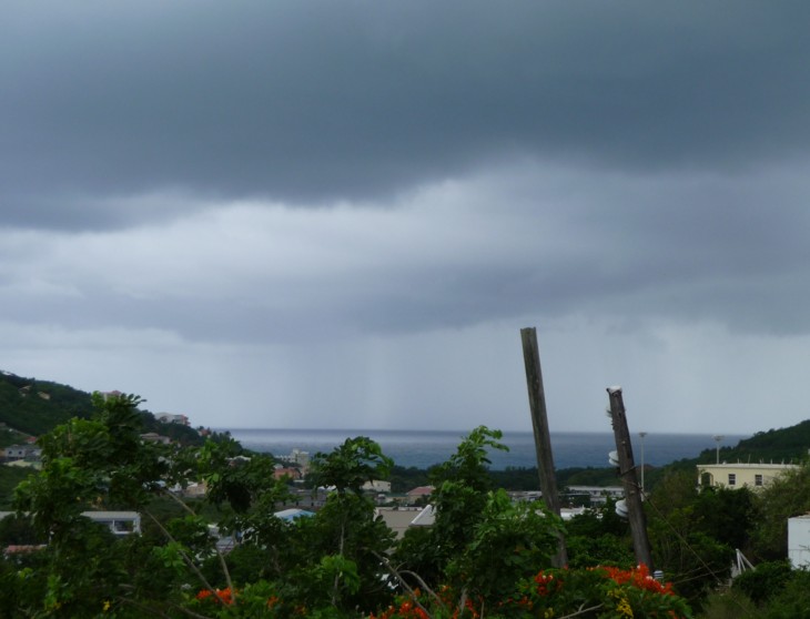
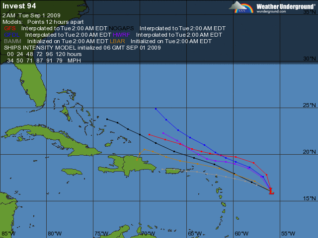
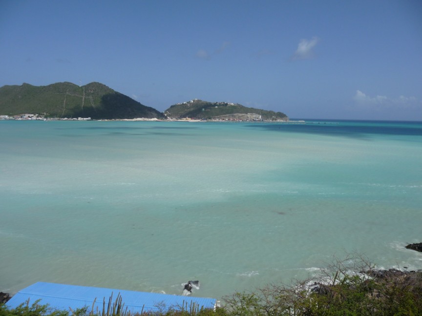
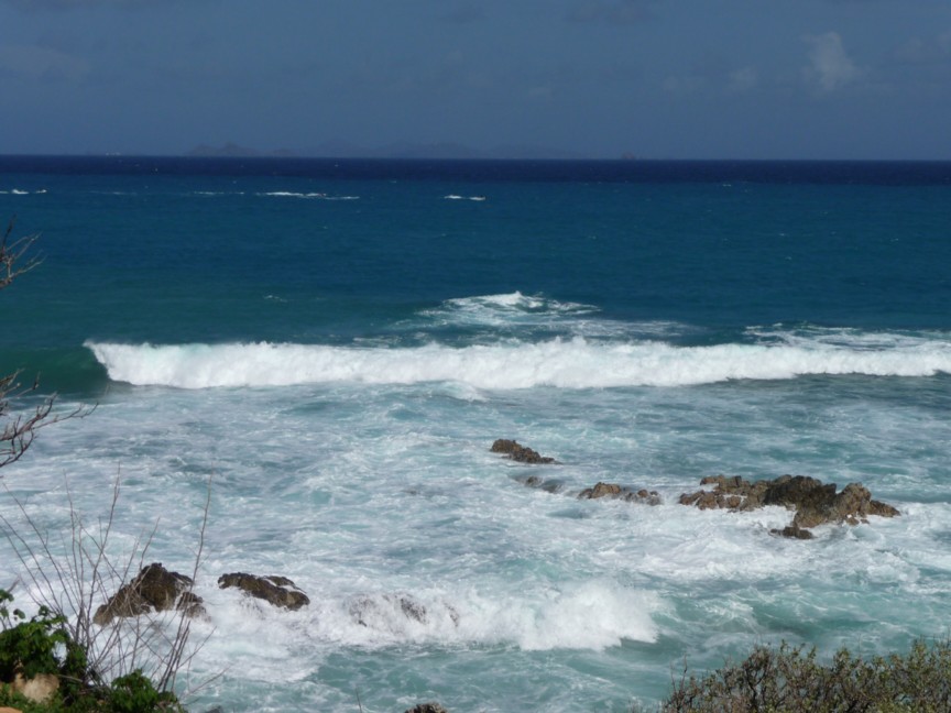

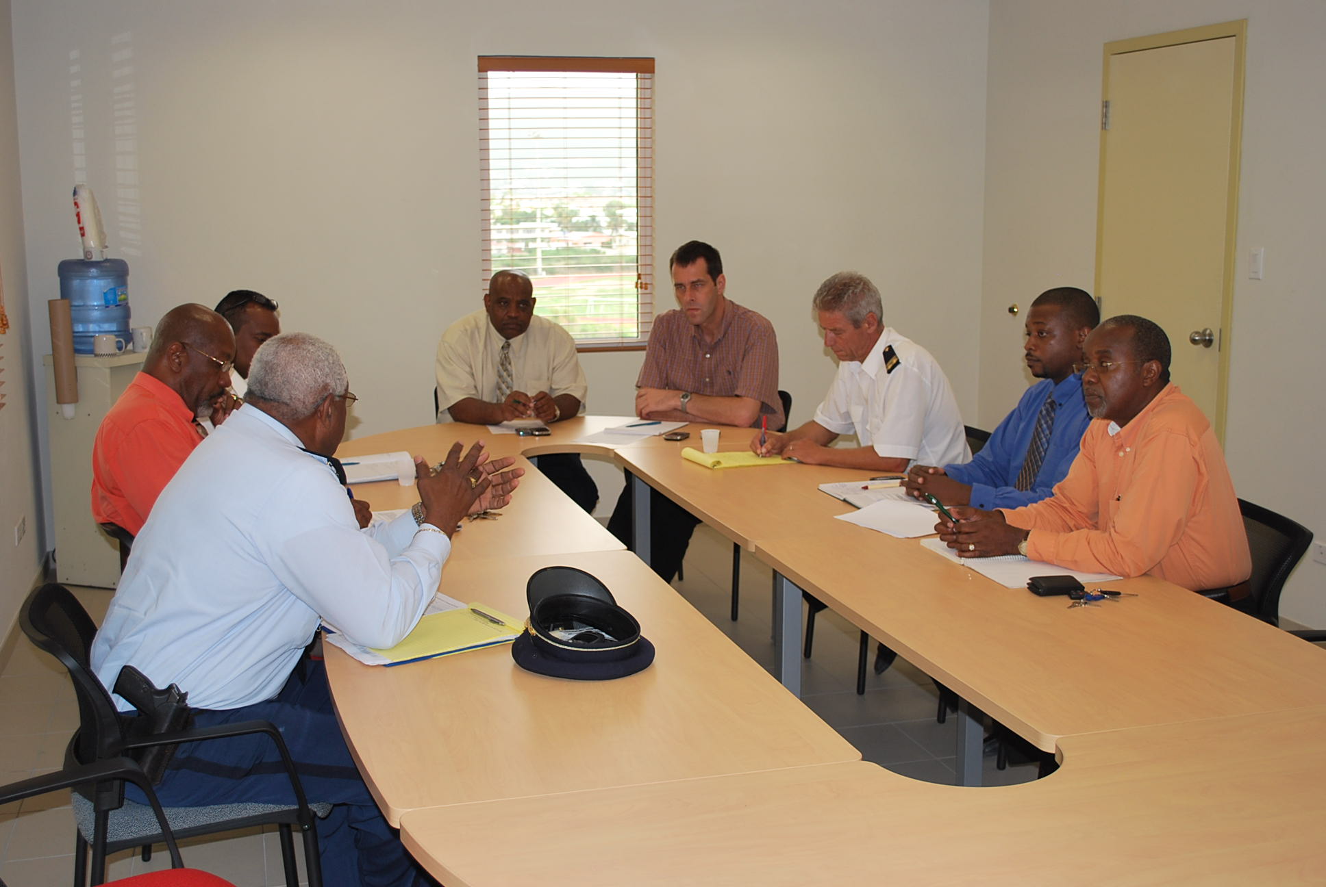
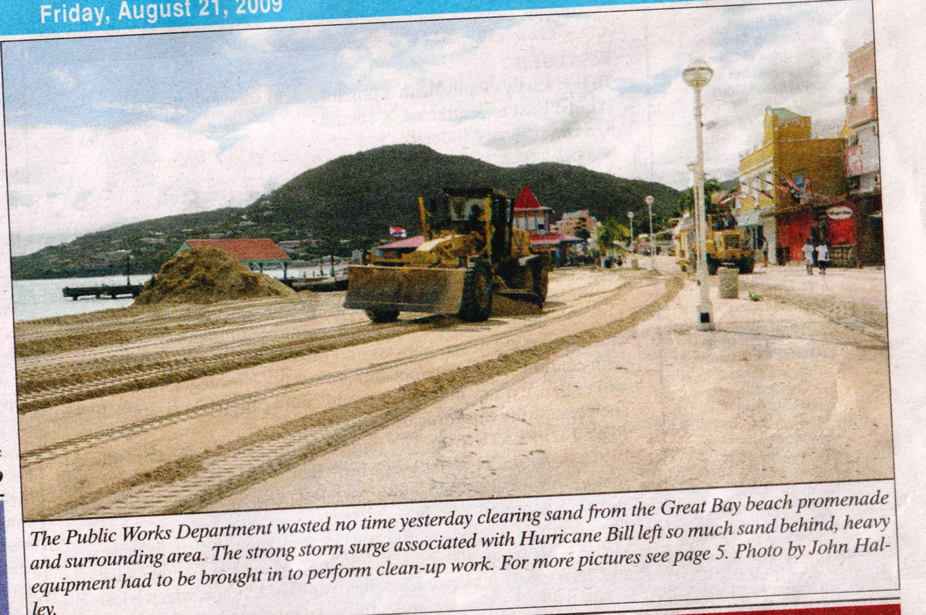
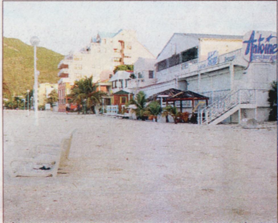
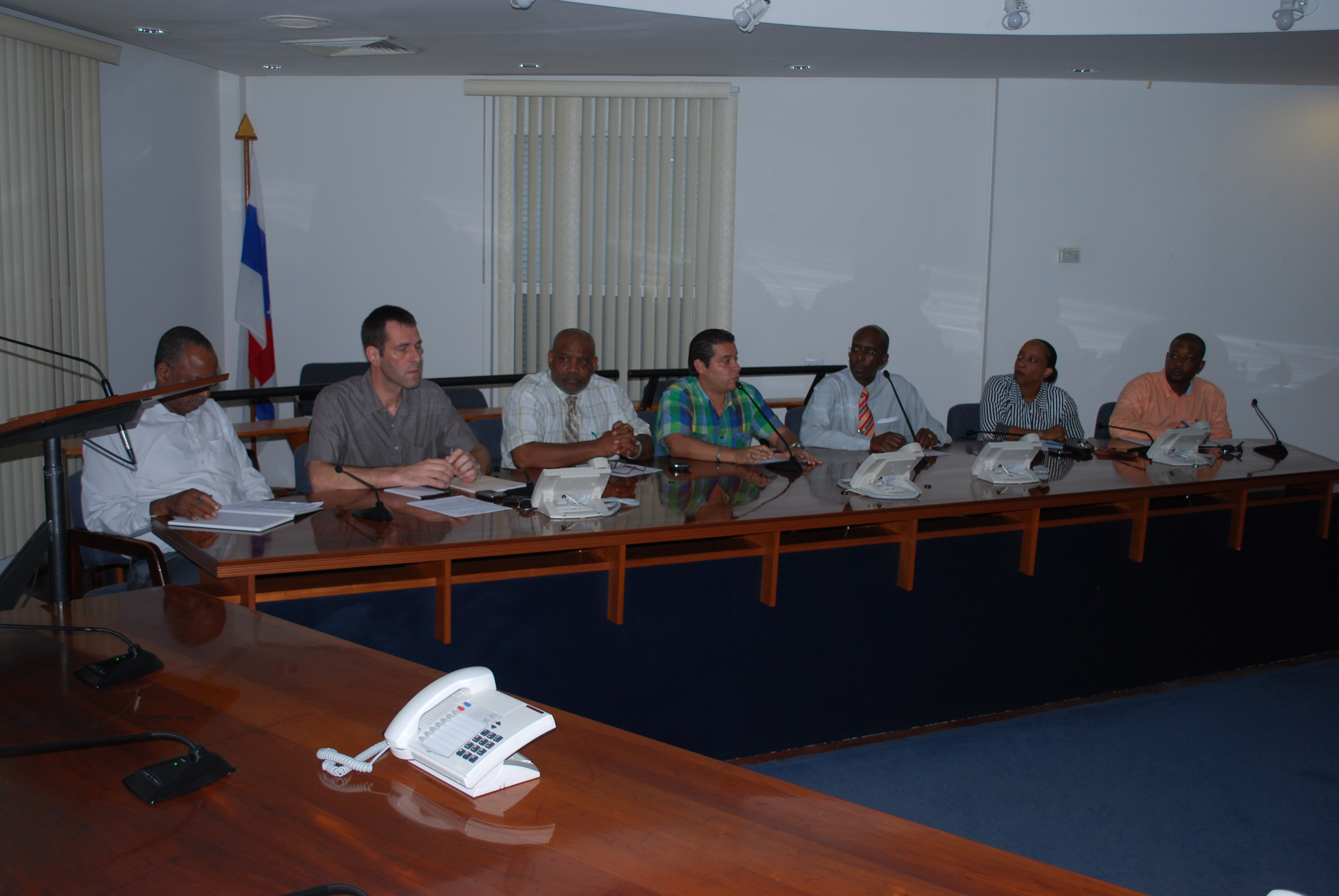
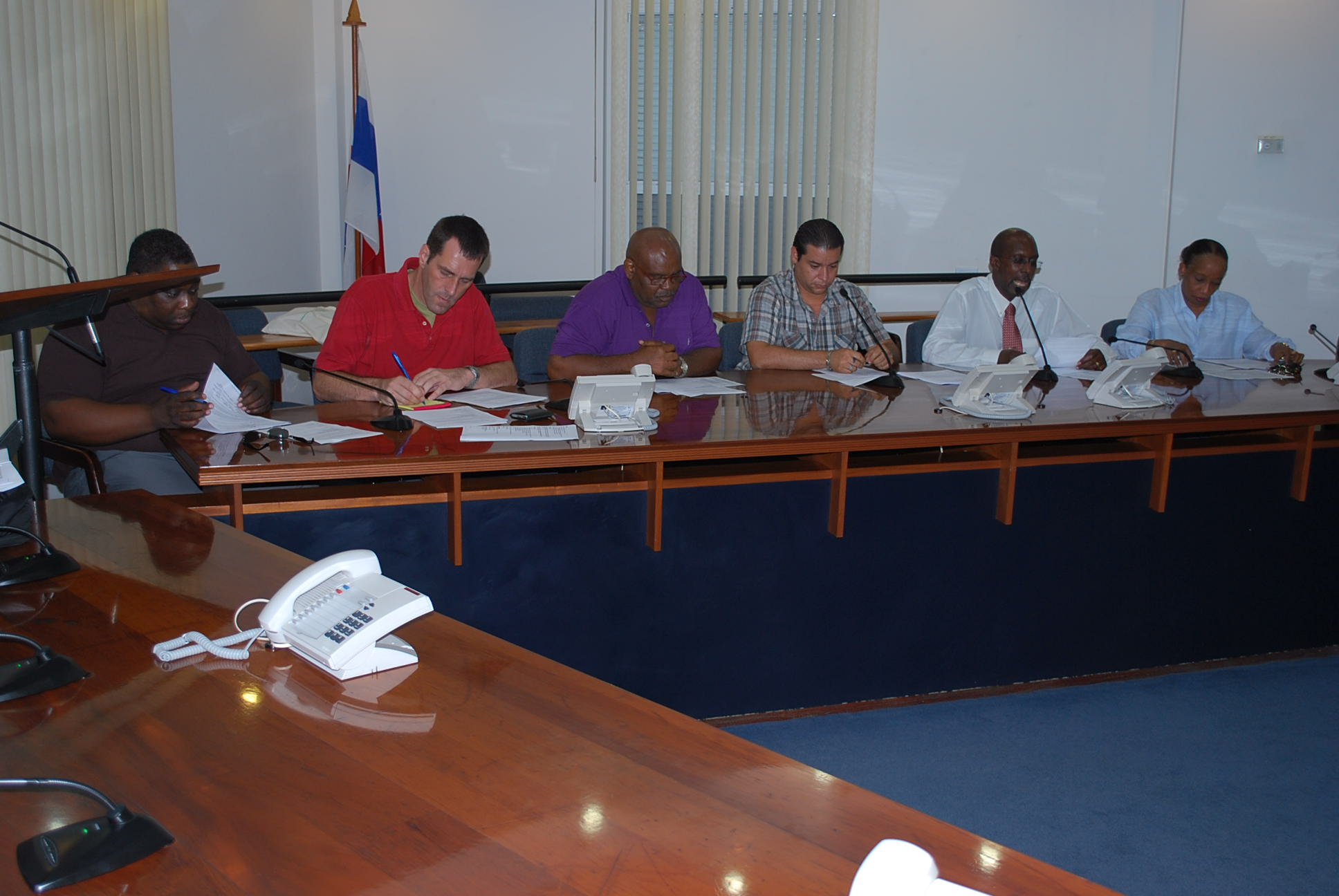