
|
- - - 2009 Hurricane Season - - -
|
- As falling
|
- By "Jean-Claude HUC" <jean-claude.huc2 at wanadoo.fr>
- Date: Thu, 11 Feb 2010 22:06:18 -0400
|
|
A lot of ash is falling since this afternoon,and
it's now affecting the whole island.
Cars are grey.The airport is closed and schools are
also closed to morrow
|
|
|
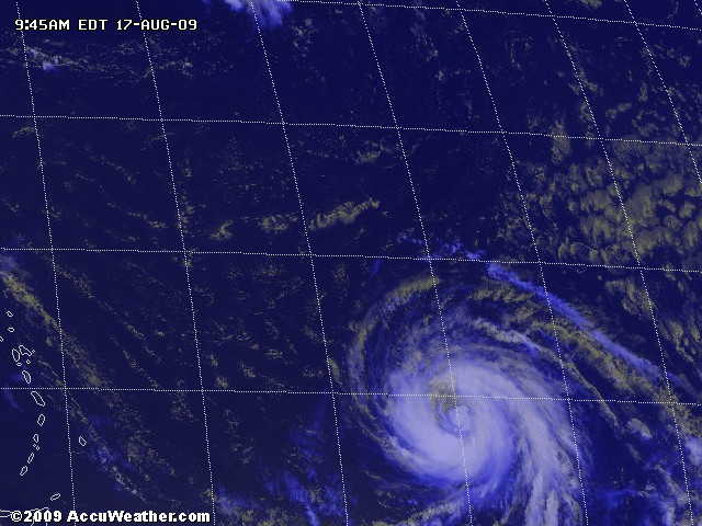
- Bill is BIG
|
- From: "John Burnie" <john at yachtindaba.com>
- Date: Mon, 17 Aug 2009 17:45:30 -0400
|
This is a big hurricane! I
really hope it does not turn left!
With Kind Regards
JOHN BURNIE
General Manager
----------------------
NAUTOR'S SWAN CARIBBEAN
s.a.r.l
GUADELOUPE
French West Indies
|
|
|
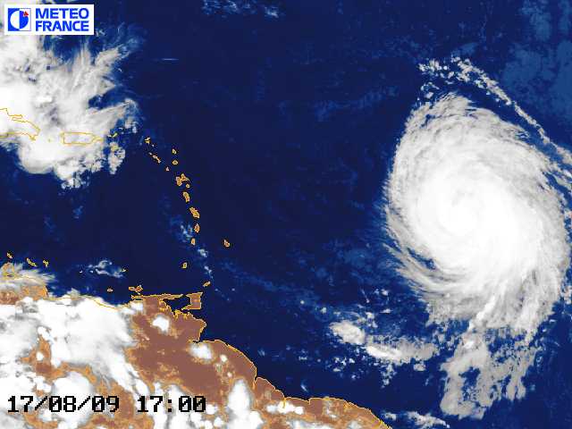
- Hurricane BILL in colour.
|
- From: "John Burnie" <john at yachtindaba.com>
- Date: Mon, 17 Aug 2009 11:56:43 -0400
|

Hurricane BILL shows impressive
circulation.
![2009_8_17_1200_MSG1_16_S2_grid[1].jpg](jpgZ6cQRoSbkU.jpg)
With Kind Regards
JOHN BURNIE
General Manager
----------------------
NAUTOR'S SWAN CARIBBEAN
s.a.r.l
GUADELOUPE
French West Indies
|
|
|
- Hurricain Bill Cooking
|
- From: "John Burnie" <john at yachtindaba.com>
- Date: Mon, 17 Aug 2009 10:32:29 -0400
|
With Kind Regards
JOHN BURNIE
General Manager
----------------------
NAUTOR'S SWAN CARIBBEAN
s.a.r.l
GUADELOUPE
French West Indies
|
|
|
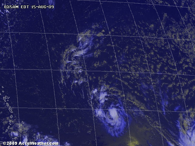
- TS ANA approaches
|
- From: "John Burnie" <john at yachtindaba.com>
- Date: Sat, 15 Aug 2009 08:59:47 -0400
|
With Kind Regards
JOHN BURNIE
General Manager
----------------------
NAUTOR'S SWAN CARIBBEAN
s.a.r.l
GUADELOUPE
French West Indies
|
|
|
- It dont look good!!
|
- From: "John Burnie" <john at yachtindaba.com>
- Date: Thu, 13 Aug 2009 18:52:24 -0400
|

Invest 90Lis showing good
potential to become a “long hurricane” crossing the Atlantic low -
in Guadeloupe we are fully preparing the vessels for a possible hurricane
strike. It is a long way off (Tue – Wed next week) but the pattern is
very similar to Hurricane Dean in 2007 - that one passed close to St Lucia /
Martinique.
![at200990_model[1].gif](gifjYwVO8o3p6.gif)
![storm_90[1].gif](gifBx4dNxsHfS.gif)
With Kind Regards
JOHN BURNIE
General Manager
----------------------
NAUTOR'S SWAN CARIBBEAN
s.a.r.l
GUADELOUPE
French West Indies
|
|
|
- Good link
|
- From: "John Burnie" <john at yachtindaba.com>
- Date: Thu, 6 Aug 2009 12:55:30 -0400
|
|
|
|
- Quite El Nino year so far
|
- From: "John Burnie" <john at yachtindaba.com>
- Date: Thu, 6 Aug 2009 10:28:44 -0400
|
|
|
|
- Good Sat Picture
|
- From: "John Burnie" <john at yachtindaba.com>
- Date: Tue, 21 Jul 2009 11:01:28 -0400
|
Nice colour picture of the
Atlantic today – shows weather past the islands and new system low down (in
ITCZ which is very clear to see) heading for S America coastline. Still v. wet
and windy here!
![2009_7_21_1200_MSG2_16_S2_grid[1].jpg](jpgrY7AgdLpDA.jpg)
With Kind Regards
JOHN BURNIE
General Manager
----------------------
NAUTOR'S SWAN CARIBBEAN
s.a.r.l
|
|
|
- Incoming!!
|
- From: "John Burnie" <john at yachtindaba.com>
- Date: Mon, 20 Jul 2009 12:40:07 -0400
|
Incoming
With Kind Regards
JOHN BURNIE
General Manager
----------------------
NAUTOR'S SWAN CARIBBEAN
s.a.r.l
|
|
|
- Big Wind in Guadeloupe
|
- From: "John Burnie" <john at yachtindaba.com>
- Date: Mon, 20 Jul 2009 12:37:27 -0400
|

Set off to Guadeloupe from
Antigua on Friday in the hope of beating the incoming weather - and we did for
the most part. Unfortunately we had 50 kts gusts near Basseterre with 40 –
45 kts constant in the Saintes Channel. Destroyed the mainsail on the yacht and
broke the goose neck – will be able to repair the sail temporarily but the
new one is already on order! Very windy over the weekend in Guadeloupe and the
Traditional Canots sailing near St Francois also had the 50 kts gusts –
out of 40 starters only about 5 finished the course! More wind and rain to come
in the next 48 hrs - this is the system we have been watching from earlier
postings. Looks like Martinique will get the worst of it. Glad to be on our
safe dock today and keeping our heads down.
With Kind Regards
JOHN BURNIE
General Manager
NAUTOR'S SWAN CARIBBEAN
s.a.r.l
Guadeloupe
|
|
|
- Good posting by Weather 456
|
- From: "John Burnie" <john at yachtindaba.com>
- Date: Mon, 13 Jul 2009 09:24:25 -0400
|
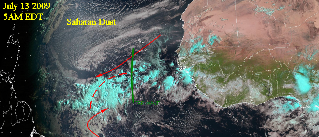
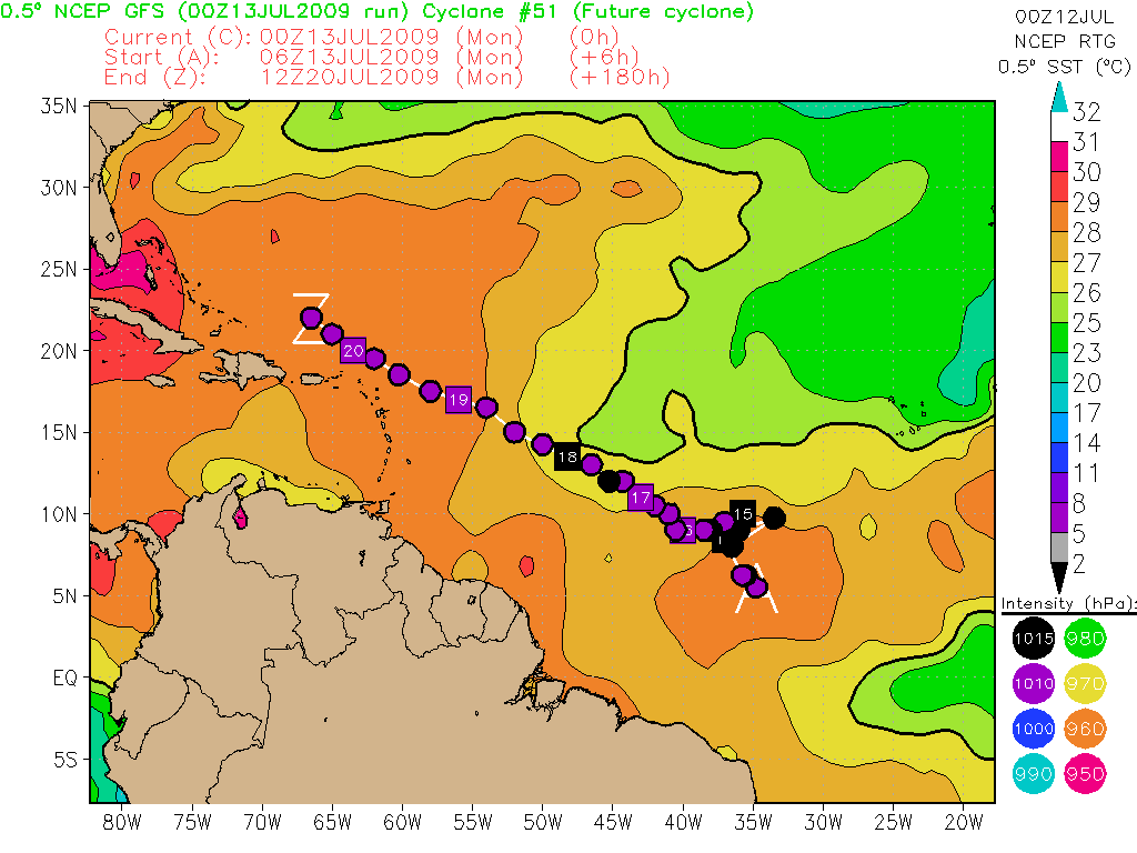
Good posting by Weather 456.
This is the one we have been recently looking at.
Let us not get to excited, but we may have
something promising to watch during this week. If you remember, that over the
past week I have looking at the GFS in developing a feature in the central
Atlantic. Though the model was alone, it was the most persistent. Now, it seems
the model is playing out. The model is forecasting an area of low pressure to
develop out of the monsoon trough in the central Atlantic, with the aid of a
passing tropical wave that emerged off the coast yesterday. On the 00Z run, it shows
a low-pressure area developing as early as today and moving off towards the
west northwest. How true is this? Well, This morning’s satellite imagery
show a noticeable increase in shower activity along a broad area of low
pressure in the Central Atlantic, and further analysis revealed the area sits
under anticyclonic outflow aloft with convergence and divergence. QuikSCAT also
revealed south westerlies south of the area of convection, which indicates the
monsoon trough rather than the ITCZ. The area sits below 10N, and the GFS
thinks it will pull north. Something I had not notice before was that
conditions appear favourable ahead of this feature for the next 5 days. By looking
at these parameters, it seems development is possible. Still I am not too
excited about it for several reasons and one being the lack of model consensus.
The models, including the GFS have not being doing well this year so right now
the GFS could be alone or bullish. I will continue to monitor this area for
further signs of development, but for now given it’s latitude and lack of
model support, there is little expected over the next 24 hrs. Regardless of
development, this feature seems to head west with a define signature along the
way. It should be near 60W by weekend, whether at South America or the Leeward
Islands is to be determined.
There are no other areas of interest in the Atlantic
Weather456
|
|
|
|
|
With Kind Regards
JOHN BURNIE
General Manager
----------------------
NAUTOR'S SWAN CARIBBEAN
s.a.r.l
|
|
|
- Long Range indicator
|
- From: "John Burnie" <john at yachtindaba.com>
- Date: Sat, 11 Jul 2009 11:27:25 -0400
|
The GFS Long Range and European Models
are starting to hint at a low developing just east of the Caribbean around
Tuesday 21st July. These indications have been discounted so far by
most observers because of dry air/wind shear values and are quoting “ghost
storms”. Sea temperatures are lower that average and all the indications
are that it will not develop. We are keeping a good eye on this particular wave
though - this is the first hint of anything tropical this season.
With Kind Regards
JOHN BURNIE
General Manager
NAUTOR'S SWAN CARIBBEAN
s.a.r.l
GUADELOUPE
|
|
|
- Good Weather in Guadeloupe
|
- From: "John Burnie" <john at yachtindaba.com>
- Date: Tue, 9 Jun 2009 12:40:56 -0400
|
Came into Guadeloupe yesterday. The
Leewards / Windwards should have excellent sailing conditions all this week.
See the sunny skies on the photo - from Puerto Rico to Venezuela only a few isolated
scattered squalls
![2009_6_9_1500_GOES12_1_S2_grid[1].jpg](jpg8LOj4jXIph.jpg)
With Kind Regards
JOHN BURNIE
General Manager
----------------------
NAUTOR'S SWAN CARIBBEAN
s.a.r.l
GUADELOUPE
French West Indies
|
|
|
- Then The Good News
|
- From: "John Burnie" <john at yachtindaba.com>
- Date: Sun, 7 Jun 2009 11:56:38 -0400
|
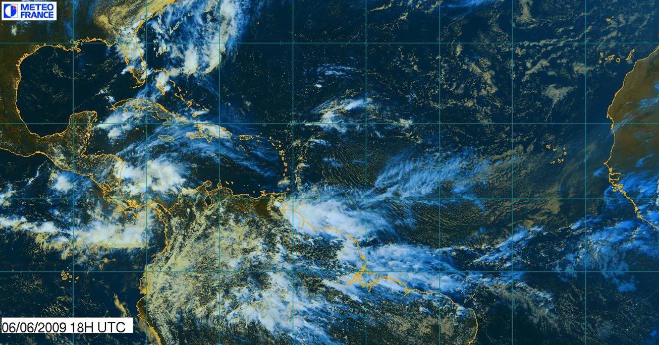
The good news is that there
really seems to be “nothing out there” at the moment. There are good
trade winds in the Eastern Caribbean and only minor squalls in small rain
showers – this week is perhaps a good time to be moving boats etc. We are
actually still well north in St Martin at this time - but spies tell me the
conditions are very similar in Guadeloupe. We will start making our way South to
Grenada as usual during June/July/August. Hope to go to Venezuela again this
year – a wonderful part of the Caribbean to visit on a sailing boat during
the height of the Hurricane Season (August – October). On the French side
of St Marin there are still a surprising number of yachts and large motor
cruisers berthed here – all well inside the “Hurricane Box” (32
North – 12 North). Marina Fort Louis (normally quite empty by now) is really
very busy. On the other hand the Dutch side is deserted, particularly in Simpsons
Bay – is this a direct reflection on the ridiculous price hikes on that
side? The bridge on that side is also closed. There have been many complaints
about the 3 week’s notice given on that – many large vessels plan much
further ahead than 3 weeks. I enclose some sat pics here that show the sunny
Atlantic with a few patches up our end near St Martin - despite the broad area
of low pressure building in the Western Caribbean the wind shear seems to have blocked
any tropical threat. Lots of rain expected that side near Cuba and up into
Florida towards the end of the week. Our thoughts at this time with the people who
lost their lives in the aircraft that appears to have broken up in turbulent weather
in the ITCZ.

With Kind Regards
JOHN BURNIE
General Manager
----------------------
NAUTOR'S SWAN CARIBBEAN
s.a.r.l
GUADELOUPE
French West Indies
|
|
|
