
|
|
- Updates from the Islands -- - Trinidad & Tobago - - |
|
|
| - New email addy. |
|
                  Please note  my email address has changed. Could not
take the (total) frustration of the last server (tstt, just so you'd
know who should not be in the ISP business).
                  While I am here, we have been experiencing some lovely
cooler temps these last few weeks. The end of the rainy season has
yielded quite a bit of precipitation and is continuing to do so
intermittently. Late November saw flooding in low-lying areas.
                  Until I have need to post again, I wish you our
readers, Gert and all my fellow co-respondents a joyous and peaceful
Christmas, and a Happy New year. May God bless and keep you all.
|
| - Joyce's tail. |
|
                  The wind has quieted down some, we are now getting
more like 15-20 mph (estimated) steady with slightly higher gusts at
times. It rained since and now it's back to a light drizzle. The rain to
the east of here looked a lot worse than we got, for a while the hills
completely disappeared under the shower. No thunder anymore. Sky has
brightened to a white hazy overcast. Flooding  has been reported in a
couple southern districts. Will continue to watch for the next couple
hours. There is a good chance we might get some more rain.. Temperature
is a wonderfully cool  23.5 C, humidity is 76% and barometric pressure
has risen a little from yesterday to 2022mb.  That's a really good sign
that it might be really over.
|
| - Sting of Joyce? |
|
                Just woke up from a nap, outside is very dark and
ominous. Winds have picked up, about 25-30 mph (estimated) with higher
gusts from the East/southeast. A bit of thunder. Cloud movement (seem to
be rushing to the northeast) has picked up significantly. If this gets
worse, a lot of people are going to get caught in it. Yup... long long
thunder roll now.
                 Sat pics show Joyce has a tail wrapped around Trinidad
from the north around Toco and way down to the south . Lightning now.
Going to have a look outside and post again in an hour or so.
                You might want to have a look at this:

http://www.ssd.noaa.gov/SAB/TROP/DATA/img/atl/catl/ir4/20.jpg
|
| - Repost |
|
I have to say, after my last post, I just lokoed at the sat pics again. Joyce is so tenacious. The pic shows that it is trying to hit us with tail. This storm just does not quit. Conditions are as decribed in my last post up to now. Will advise if any change. |
| - Who's Joyce? |
|
                 So there we have it, more or less. Joyce is yet to make
any kind of significant impact  here. We went to church this mornng and
the attendance was 90% of the norm. I guess the exceptions would have
been people who have to travel longer distances and do not have their
own cars.
                            This morning has been punctuated by some
light to moderate rain, very overcast all round at the moment but
nothing worrysome in sight. One report from the south says pretty much
the same. People are beginning to go about their bisiness as usual.
Several events carded for this evening are on as planned. All thanks be
to God. It could have been much different.
                            Hi to fellow correspondents, Graham I
haven't run into you for a while, but I hope all is well. Regards to all
the others up the islands, looks like Granada's up to bat with Joyce.
May the Lord be with you all.
|
| - Joyce |
|
|
Thankfully and yet again our blessed islands have
been spared. The "Storm Warnings" have been officially lifted from both Trinidad
and Tobago. Its been a steady but light rain for the past 2 hours with very
light winds with a warning about the possibility of thunder showers
.
This will be my last report on "Joyce" so now I can
"officially" relax and the family has decided to have a BBQ, despite the rain,
and I think I will have a nice cold beer. I hope I was of some help and
lets not forget our friends in Grenada where Joyce seems intent on
visiting.
Cheers everyone !!
Graham A. Bell
Diego Martin
Trinidad
|
| - Joyce |
|
At 1200 local time on the NE tip of Tobago the wind is 5-10 from the east, the sea shows a slight swell and the rain has let up. For the past 2 hrs. the wind was from the south AT 25 Kts with gusts to 30 Kts. and white caps. There were periods of rain but not heavy rain. This one was a pussycat. |
| - Joyce |
|
Sunday 9.00am. Rain started at 7.45 and is continuing. According to a friend at the Met Office, it is now a minimised storm, with perhaps high winds but lots of rain. Thunder has been rolling in the distance for the past hour. In one area (Lowlands) there apears to have been a lightning strike of a transformer or something, as some friends report they have lost power. Otherwise it looks like another rainy day. At least for now. David |
| - Joyce |
|
|
Finally got some information from Tobago. It seems
that it is very overcast with some rain and very little wind. my contact says
that its now wait and see. As I am typing this message I am hearing, for the
first time, some thunder rolling.and ,while its a low and quiet roll, it seems
to be comming from the east. I have just looked outside and there has been a
definite increase in in cloud build up in that region
All for now
Graham A. Bell
Diego Martin
|
| - Joyce |
|
|
Well its just about 7.00am on Sunday morning and
here in the Diego Martin valley situated in the nort-west peninsular of Trinidad
and there are blue skies off to the south with overcast conditions to our
north-east. It continues to be very still with little or no breeze. So far we
have had a few heavy showers but nothing out of the oridinary.
The latest locaf bulletin has Trinidad still under
a storm watch while our sister island of Tobago which is situated to the
north-east of Trinidad is under a storm warning. Madame "Joyce" as at 6.00 am
has not made landfall yet on Tobago. The local met people are still warning of
"severe feeder bands" of rain clouds that will affect Trinidad and have also
reported that the most of the wind activity will be to the east of the storm.
Good news for Trinidad but unkind news for Tobago and Grenada.
I will try to make contact with someone in Tobago
to see how things are shaping up.
Graham A. Bell
Diego Martin
|
| - Joyce |
|
At the NE tip of Tobago it is beginning to rain lightly at 0700. Thunder started about 0615. There is no wind yet. Looking west the sea is calm with a slight swell. |
| - no joyce 4 us |
|
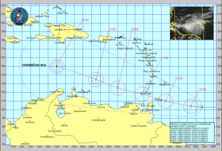
Hi and a pleasant sunday morning form good old T & T.
I am back, and fortunately or not, with not one
picture of high waves/flood/broken homes, u know ..the
"stuff that makes bas news"
The good news is a chart of the present location of
Joyce, and as we speak, I am talking via "CB radio" to
Tobago, to c if she touched them and how badly.
So, stay tuned..

=====
Keith Ferreira
url..www.geocities.com/keithf5438
keithf AT geocities.com
keithferreira AT hotmail.com

__________________________________________________
Do You Yahoo!?
Yahoo! Photos - 35mm Quality Prints, Now Get 15 Free!
http://photos.yahoo.com/
joyce3.gif
|
| - update on Joyce |
|
Time.. 12.55am on Sun 1st Oct 2000. I am now about to
head in an eastly direction to bring u and the rest of
the world, up dated pic on "on goin stuff" happening
in Trinidad as the 2am approaches.
So far so good, ie not much of anything,so wish me
luck, and chk back in about an hr or so, got my
digital camcorder and off we go..ttyl.
don't worry, I did this sort of thing before, and I
know when to get out..:-)

att1 chart at 11pm 30-9-200
att2 chart at 12.45am on 1-10-2000

=====
Keith Ferreira
url..www.geocities.com/keithf5438
keithf AT geocities.com
keithferreira AT hotmail.com

__________________________________________________
Do You Yahoo!?
Yahoo! Photos - 35mm Quality Prints, Now Get 15 Free!
http://photos.yahoo.com/
picofjoyce.gif
joyce2.gif
|
| - Update |
|
It is 12.55 am Sunday October 1, 2000. No sign of Joyce yet. I went to a meeting Saturday at 5.00pm with a forecast that called for torrential rains and gale-force winds in the afternoon/evening. Usually there would be about 80 people but only 39 turned up. Neither did the forecast conditions. The only event was a dead calm. Meanwhile in the Scarborough Market Square hordes of revellers were celebrating the 2nd. annual Tobago Fest, a Carnival in September, with some bands from Trinidad in full splendour. Not a thought of any storm. By 9.30pm there was a slight breeze and by 10pm a peal of thunder. Nothing since. Well, probably tomorrow! David. |
| - joyce |
|
I live in the Eastern part of Trinidad,and at 9.30pm all is calm.We have already recieved notices from all tv/radio stations, governmental agences and most of us are expecting the worst.We have never been exposed to any wind gust over 25knots, so you can imagine our dismay. I hope to post pictures as soon as "something" begins to happen, so stay tuned. Keith Ferreira ===== Keith Ferreira url..www.geocities.com/keithf5438 keithf AT geocities.com keithferreira AT hotmail.com __________________________________________________ Do You Yahoo!? Yahoo! Photos - 35mm Quality Prints, Now Get 15 Free! http://photos.yahoo.com/ |
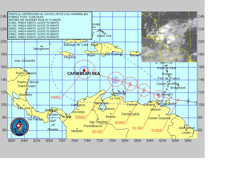
| - Joyce |
|
|
As Joyce continues to make her steady track towards
us, it appears that most "Trinis" have taken the warnings seriously. They were
some lines in the Gas Stations as people filled up their cars and grocery stores
reported an upsurge is sales of basic and canned foodstuff, candles
etc.
Right now the night sky is quite clear but there is
not a breath of wind and the "mugginess" as a result of the humidity is heavy in
the night. Around our neighbourhood, people have quietly prepared and have made
all efforts to secure loose items in the yard etc. "Trinis" however will be
"Trinis" and the big calypso show that is carded for tonight appears to be still
on.
The latest local forecast at 7.00pm Eastern
Caribbean time stated that "Joyce" will pass just north of us with winds
at 50-65 kph with gusts up to 85kph. There was also a report that the east
coast of the island has started to experience some showers. However I am unsure
if this as a result of "Joyce" or just normal localised rain which is common at
this time of the year.Weather bulletins will be issued every hour and I
just caught the 8.00pm bulletin which stated that "Joyce" continues to be poorly
organised (thankfully) and we can expect to get the real feel of her from 2.00am
Sunday morning.
Lets all say a quiet prayer for a gentle meeting as
possible with Madame "Joyce"
Graham A. Bell
Diego Martin
|
| - First sign. |
|
                 Radio advisories are being broadcasted outlining
preacutions be taken  and systems in place to deal with whatever is
forthcoming. Assumptions are based on the Tobago landfall projection
leaving Trinidad to deal with heavyrains and possible flashflooding on
areas so prone.
                Emergency supply kits should be kept handy. People
should stay at home unless it is absolutely necessary to leave effective
midnight. Identify safest areas in homes (smallest room usually the best
bet) to shelter with family members during the storm. Also cleanup
precautions around homes to minimise any possibilities of loose items
becoming missiles in high wind circumstances.
                I took a walk outside a while ago and there has been
some change in the general outlook. Cloud cover more ominous to the
northeast. Overhead a layer of stratus type cloud was casing a curious
yellow light all round , and there seemed to be different colours
(refraction) in a random pattern from cloud to cloud, a piece of a
rainbow was visible over east Port of Spain from a light drizzle. Just
then the sun set.
                Temperature  29.5C , barometric pressure is 1021mb and
the humidity is 65%. Whatever happens we are going to get some rain and
possibly gusty winds. Latest sat pics show Joyce although broken up
considerably, is one tenacious system, it now has a  feeder band off the
South American continent.. The one connection between Joyce to it's own
"predator" which is what has kept this system at bay throughout is now
breaking up. It also did that about this time yesterday afternoon. That
mid Atlantic system is now also close to Isaac's tailend. A reduction in
"drainoff " form Joyce could see our emminent system beginning to inhale
(again?). We may begin to see some rain by midnight. More later if
there's anything to tell.
|
| - No Joyce, rejoice. |
|
                    Joyce has continued to be deflated by that  low to
it's north-east as the connection between the two resumed today.
Presently, we have a light haze, the sun is trying to peep through. To
the east and south-east( I am in Port of Spain) there is some light
cloud but nothing ominous. Occasional light gusts from the north.
Nothing unpleasant. Temp is 30 C, barometric pressure 1021mb and 65%
humidity. I supose it may get worse a little later but so far all is
calm.
                People have continued to secure broken windows and tie
up loose ends generally. Someone told me,  "no storm eh coming here, God
is a Trinidadian."
                 It seems that Keith is stealing all the thunder. One
look at the sat picture yesterday and it seemed set to become a monster.
The people in that region have really taken a beating in the last couple
of years. Mitch is not even gone from immidiate memory as yet. Hats off
to all Antiguans, I consider you seasoned hurricaners. We still have not
had our first. Mebbe God does live here afterall, or maybe he has
special interests.
|
| - Waiting, watching. |
|
         This morning a watch was issued at 5.00 am by the authorities.
Joyce continues to defy projections which turn her north. Last
observations from satellite pictures indicate another south westerly
shift. It looks like Joyce was playing dead to catch corbeaux alive
yesterday. This morning the storm is looking better organized and we
will have an opportunity to get what emergency items are need. Being
Saturday, many stores will be closed, of those open  many normally close
by 12.00 noon. That leaves the malls and odd late opener for any
shopping.
          In checking the records I realise that no hurricane has ever
made landfall here. We had a close call way back in 1933 , when an
un-named system passed through the Columbus channel, but only tropical
storms have really hit . In posts of years gone by I already stated how
vulnerable that makes us. We are not as experienced as our northern
neighbours, neither have the structures here been really tested by such
a force, I believe that if we do have a major hit, there will be much
destruction. Resedential structures, many of which have not been
constructed with this sort of thing in mind, are most at risk.
           I always thought of us as living on the sidewalk of hurrican
alley, well, here comes a drunken driver all over the sidewalk. Lets see
what she does.
|
| - Joyce |
|
|
As at 5am this morning Sep 30 Trinidad has been put
under an official storm watch. the morning has dawned and it looks so far to be
a picture perfect morning. Although Joyce has not made her north-west turn as is
being predicted, the forcasts are suggesting that between tonight and tomorrow
morning we should start to feel the effects of this unwelcomed
lady.
I will try to keep you all updated on how us
"Trinis" prepare and deal with her arrival
Graham A. Bell
Diego Martin
Trinidad
|
| - Here we go. |
|
Hi everyone,
                   My first post for the season. Thus far there was no
reason to post anything. Now, there's Joyce. I've been keeping an eye on
this hurricane/storm for the last four days. Joyce has done everything
other than forcasted. Now, broken up a great deal in the last
twenty-four hours from the "parasitic" effect of the hugh low pressure
area to its north east, which has been "syphoning" off Joyce, the only
way I can see it (Joyce) reorganizing is if that narrow band connecting
the two systems is broken, then Joyce will be free to feed off the warm
waters off the South American coast and reorganise. Every hour that
passes and that connection remains, the chance of Joyce regaining any
punch is diminished. I have not seen a system this far south in my four
years of "monitoring". It's troubling and I know as each year passes and
we are spared it is one year less to our next hit, God alone knowing
when that would be.
                  There was a great deal of turmoil in the Gulf of Paria
yesterday. A freak storm hit from the south west, very unusual. There
was damage to small craft in the Chaguaramas area. I caught a glimpse of
the waters off Mucurapo while going east on the Forshore Highway, it was
"boiling". To see any wave break on that shore is a rarity, they were
six  footers. This morning, live aboard residents awoke to a massive oil
slick, the damage from which is sure to be very costly, both to marine
life and boat/yacht owners. Fortunately we keep our pirogue in a shed.
Everything afloat is caked in oil about their waterlines. The Coast
guard has been distributing free dispersant to the affected. Little help
this is to the fishermen and marine life at this stage. The damage has
already been done. By tomorrow the dead fish are going to be showing up.

                  As we await Joyce's path to become more evident, most
people are going about their business as usual, with the addition of
some precautions, like securing batteries and flashlights. No masking
tape going up on windows yet. No long lines at the supermarket. Too soon
for that. I had one yachtie who wanted some ply cut in a hurry, he was
taking off for a river in Venezuela. By tomorrow evening we shoud be
more certain of what lies ahead a la Joyce. So long for now. God bless
and keep you all.
|
| Back to top |
