![[IMG: Luis; Credit: Norm Nelson, Bermuda Biological Station for Research - http://www.bbsr.edu/Weather/]](http://www2.gobeach.com/luis5.gif)
|
The Caribbean Hurricane PageUpdates from the Islands- - St.Thomas (USVI) - - |
More recent reports can be found on another page
| - 20:00... |
|
|
...
Conditions slowly "improving" here at the house. Use the phrase
"improving" because it was never really
bad during the day.
Transformer must have just blown up somewhere in the area. Loud explosion, lights flickered once and then went out all together. Fortunately just had dinner heated up in the microwave. 'Lenny' now 929 mb (!!!) with accompanying 130 kts (!!) sustained winds (!!!). A very strong category 4; if not a category 5!! The hurricane is NOT looking
good at all for Anguilla, Saba and St. Martin. Worse part is that
the winds will be hitting these islands during the night. One can
only hope and watch!
Please check the posted messages from the other caribbean islands even
though they are not directly influenced by hurricane 'Lenny'.
Herman
|
| - Looney Lenny |
|
I'm with Herman! Confusing to say the least. Lenny the Looney! From my vantage point, the wind has changed direction and picked up quite a bit. The power is on again though, so I dunno.....guess we still have a way to go. I'm hearing scary stuff out of St. Croix, but much worse down island. I'm still counting blessings here, as so far the section of Hull Bay road I can see is still in pretty good shape. Though the water is flowing out of Magen's instead of in, it too appears to be relativley unharmed thus far. Hanging in there and sending tons of positive energy southward.... |
| - Confusing... |
|
|
...
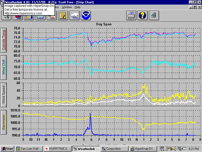
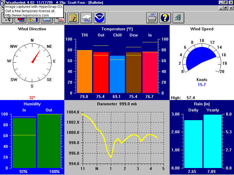
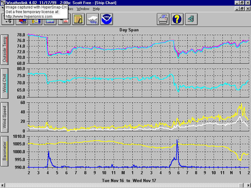
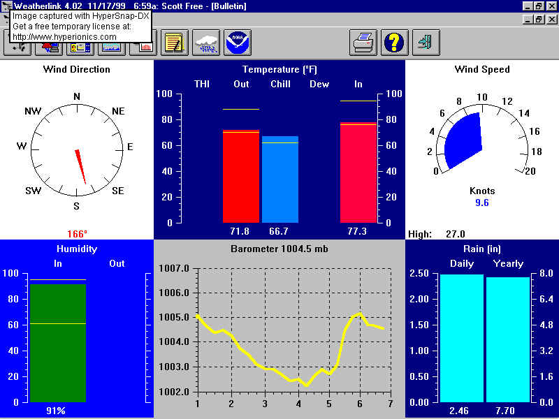
Experiencing 'Lenny' is becoming quite a confusing task from a personal standpoint. Listening to the local radio, ("Mongoose 104.9 FM" which has been doing very good work today), makes it sound like there's something we're missing here at the house. The radio is reporting problems all around. St. Croix is getting hit pretty badly. Rescue workers trying to get to people, trees uprooted, high wind gusts reported, heavy seas and damage to the F'sted pier reported. And here at the house all is rather quiet!! Winds are between
10
and 20 kts and the barometer is
999.0
mb (29.50 in).
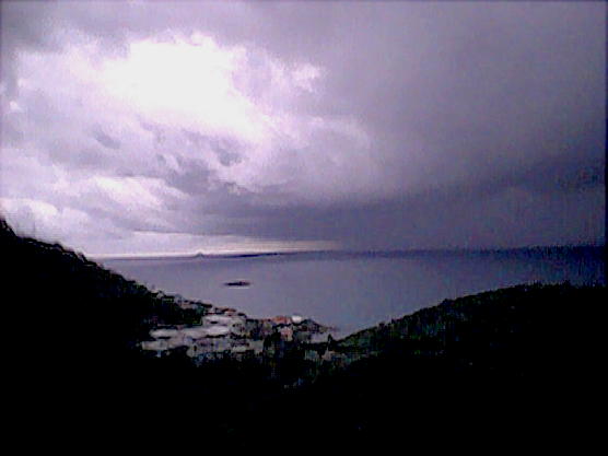
See files 'House.jpg' and 'Detail.jpg' below for latest weather conditions. Herman
|
| - St. Thomas |
|
I am in the Emerald Beach Resort near the airport on the south side of St. Thomas. The winds have been fairly mild until now, but we started getting some strong gusts around 13:00 AST which is when the power went out. The wind seems to have been coming from the north and we have been in the lee of the mountains, but it seems to be shifting. The waves are high for the area and some are reaching the base of the building, although there doesn't seem to be any damage or water getting into the rooms. We are close to the power generation station so it is possible that power is out for the whole island. |
| - Weather... |
|
|
...
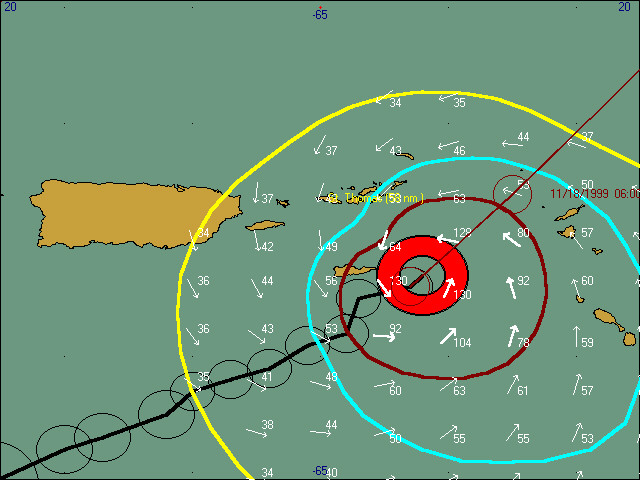
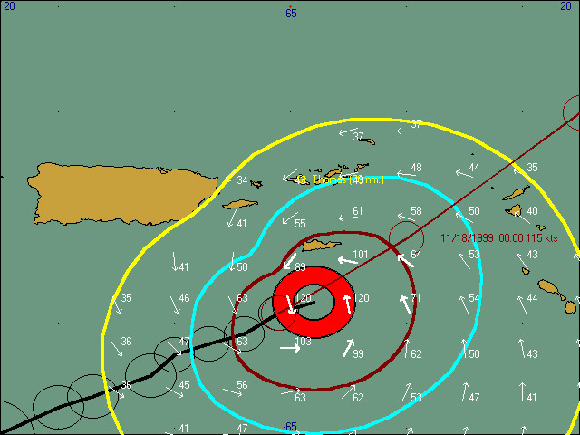
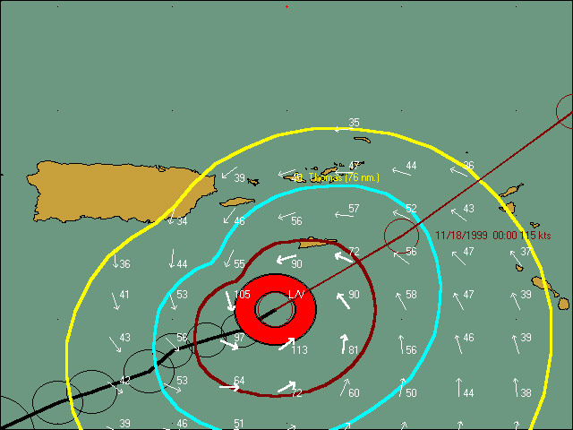
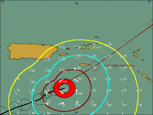
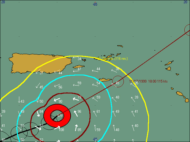
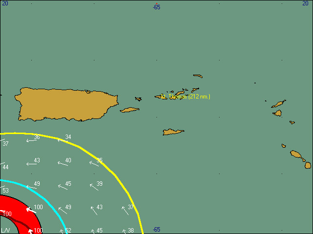
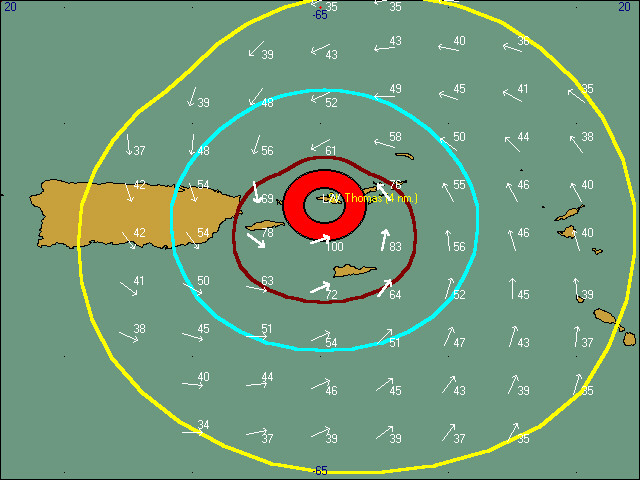
Weather is slowly deteriorating. Just lost power half an hour ago. Phone, obviously, still up. 'Lenny' at 13:00, once again, defies the 11:00 forecast track and moves just a little east of it (see 'Lenny.jpg'). Central pressure now an unbelievable 933 mb (!!) with accompanying wind speeds of 140 mph (120 kts!!). Coast Guard just broadcast "Pan, Pan" on VHF channel 16. "Yacht
64
nm SSE of St. Croix in distress!!!!"
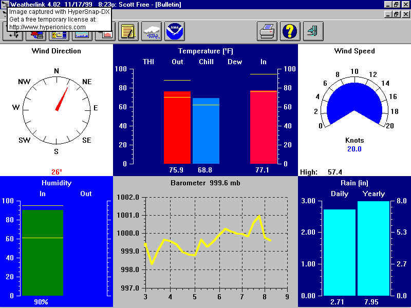
Recorded highest wind gust of 57.4 kts
at 13:10 (see 'House.jpg').
Many people have asked where the "Wind field" graphic files come from
(see 'Lenny.jpg')
Two yachts moored at the old slipway on the north side of Hassle island are riding up against each other as the swell in the corner is quite substantial. Have front door open as the wind is not that strong. Fresh breeze around the house plus saves on lantern fuel and batteries. |
| - [Fwd: Afternoon with Lenny] |
|
Well, hopefully the worst is over. I can't believe this thing went to a CAT 4! God Bless those still in the path. The wind here (Hull Bay Road near E&M) is pretty crazy, raging on eminute silent the next, though I've seen much worse. There seems to have been a salad explosion all over the driveway, but I think Georges tore up more vegetation. It hasn't been raining all that much either. Apparently we have been spared again. My thoughts and prayers begin to turn toward other islands as I begin to realize that St. Thomas is taking a good hit, but not a devastating one. |
| - 11:00 Update... |
|
|
...
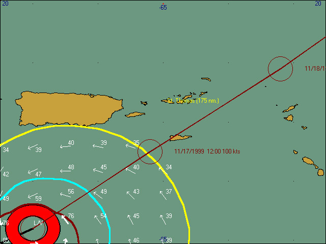
Latest 11:00 advisory shows 'Lenny' to pass just to the east of St. Croix. See attached file below ('Lenny.jpg'). Please note the interesting "dent" in the NW quadrant
of the wind fields. This is the influence of the mountain range "El
Junque", located on the island of Puerto Rico!! Stand corrected but
reckon the mountain range's height to be something like 8,000 ft or maybe
higher. The mountain range has clearly deflected 'Lenny' and moved
it more onto it's present track. Quite sure that St. Croix isn't
too thankful for that info.
As noted in the previous message:
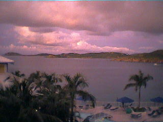
Weather here on the island of St. Thomas definitely not bad at all. Sure, it's not a beach day, but it can be much worse than what the current conditions are on the south side of the island. See attached file below ('house.jpg' and 'detail.jpg' ) for the conditions here at the house overlooking Water and Hassle island, and the Crown Bay area. One good thing the south side has going for it is that we'll be protected from the strongest northerly winds that are expected. Visibility is not bad at all. 'Buck' island and 'Frenchman's Cap' are visible and there has not been that much rain this morning. However, plenty of rain during the night which can be described as a "Totally Wet" night. Herman
|
| - lenny (what else) |
|
It's 10am Nov 17. We are facing Charlotte Amalie Harbor and the winds have just started to increase. Maximum winds have only been around 30 knots. Rain is sporatic. Surf in the harbor has increased. Still have power on feeder 7 and looks as though its time to take the dogs out. Sail la vie. ____________________________________________________________________ Get your own FREE, personal Netscape WebMail account today at http://webmail.netscape.com. |
| - St. Thomas update... |
|
|
...
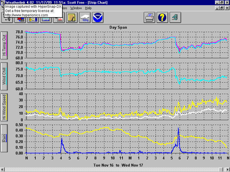
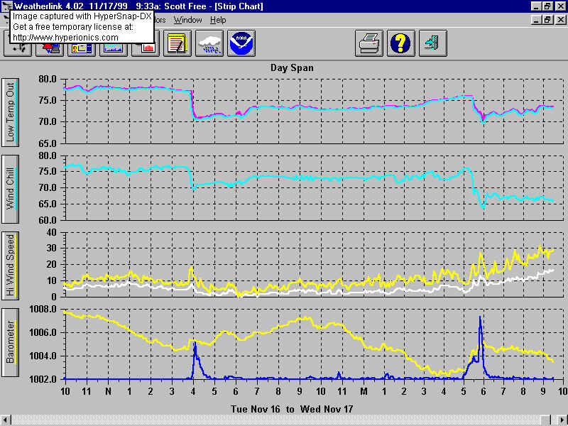
Winds have been slowly building up since 08:00 this morning. Sustained
winds now in the 20 - 25 kts
range. Mainly from the East. The eastern side of St. Thomas
must be experiencing heavier winds than we here at the house, since the
house is very well sheltered and protected from the Northwest, North, Northeast
an East.
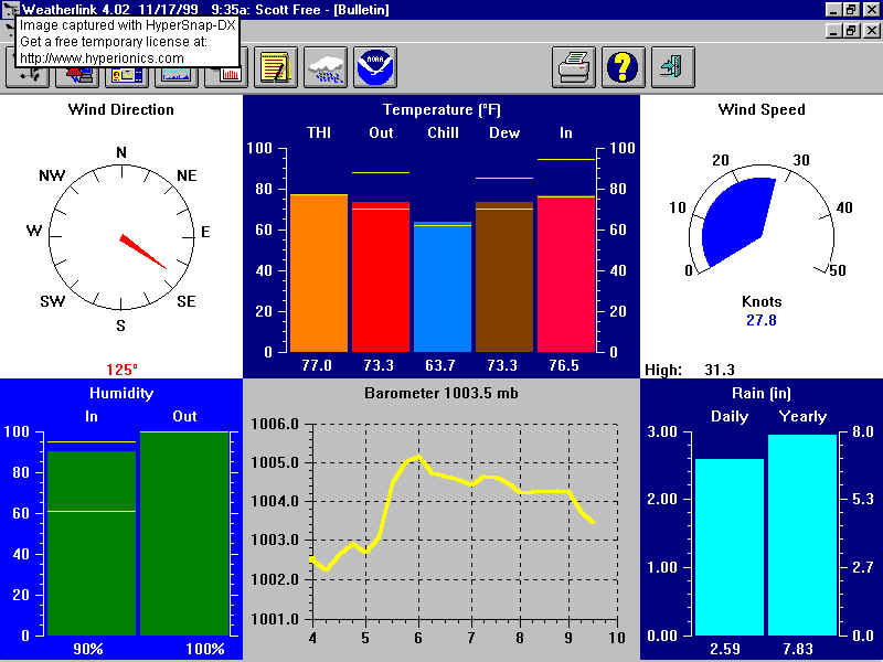
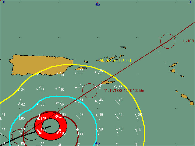
For those interested; the attached two files below ('Detail.jpg' and 'House.jpg') show the conditions here at the house as of 09:33. "Lenny's" position at 09:00 was (again) slightly east of the 05:00 forecast
track. See attached file ('Lenny.jpg') below.
Local radio reporting that there is only ONE
(!!!) shelter open on the island of St. Croix!!!!!!! With their generator
NOT
working!!!! This on an island with +/- 50.000 inhabitants!!!!!!
Local observations around the house and down the mountain:
Waves pounding and breaking heavily on the SW side of Water Island,
over 'Porpoise Rocks' (close by). This also means that these waves
will come into the 'Elephant Bay' area
soon!!!
'Spare' trying to sleep, but not happy due to trauma from past. Tuna seems to work in calming her down. Herman
|
| - lenny...??? |
|
wow!!! i have seen hugo,marilyn,bertha,and georges and more... rain is pouring now thunder and lighting intense power flickering.. local station wsta on generator.. addie ottley no weather channel any more have to depend on my page for links to weather news. see it at http://members.theglobe.com/huckphotovi the lighting is intense...very close!!! continueous strikes. thunder shaking house... dawn approches... reports of of flooding starting..nadir gut is flooded across the road...run off causing flooding everwhere... morning calm first photos from the deck see blenn.jpg... get latest updates at http://members.theglobe.com/huckphotovi huck 7am st thomas ______________________________________________________ Get Your Private, Free Email at http://www.hotmail.com |
| - Weather conditions... |
|
|
...
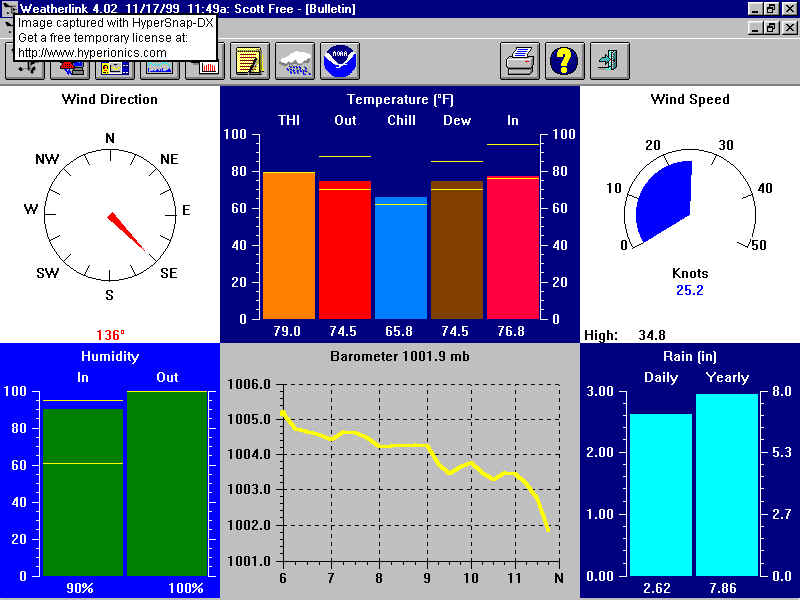
Power still on...., phone still working...., rain still coming down
(only not that hard anymore)...., lightning and thunder
For those interested, click the two graphics file attached below to see the latest weather situation here at the house. Local radio mentions that St. Croix and the BVI will experience hurricane
force winds today. Hope all the boaters have read my
'Spare' just been given her 'tuna-fix' and calmed down again. Strange hurricane!!
Time once again to check another (intermediate) advisory. This time the 07:00 one. Herman
|
| - Morning... |
|
|
...
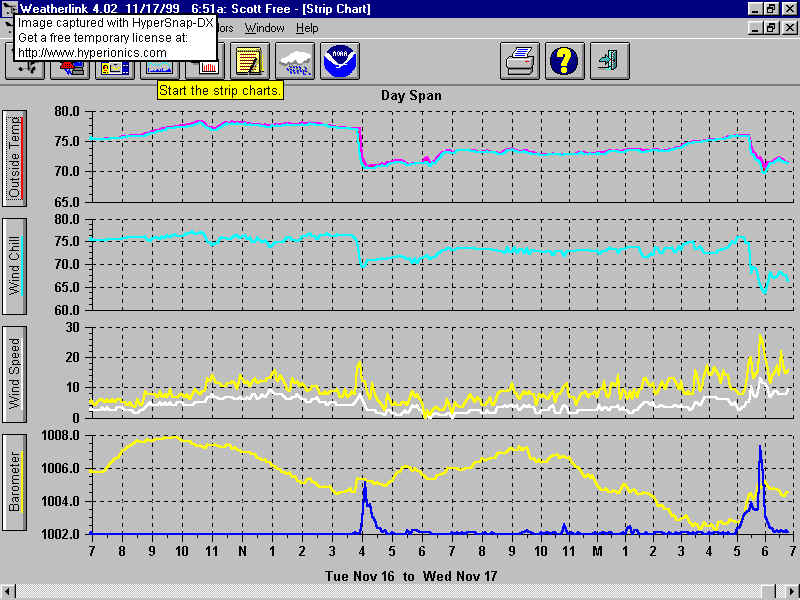
'Lenny' getting stronger. Pressure now 950 mb. Winds now 110 kts. Eye diameter is 20 nm. Very heavy thunder and lightning!!!!! Rain now nearly torrential (2,26 in. since midnight). Beating against the shutters. Winds picking up. 'Lenny' must make a northward track NOW to make a direct hit on St. Thomas. Looks like the eye is NOT going to pass over ST. Thomas. See attached file below. Pressure here at the house RISING again (???!!!??), 1005.0 mb (29.68 in.). Wouldn't mind finding out why it's doing that. Lightning is constant flashing across the morning sky. St. Croix (on radio) getting pounded by battering waves. WInds
are still picking up and situation is going get a lot worse.
Power and lights flickering at times. Radio announces that feeder 9B is out. Means people in the East end and St. John are without power. 'Spare' NOT happy at all. Herman
|
| - Good Morning Lenny |
|
Woke up about an hour ago when it sounded like the thunder was coming from inside my head! Nice little storm we've got going here. Miracle of miracles, we have power and phone still, though the power has been unsteady for awhile now. Wonder how much longer it will hold. It's raining pretty hard and the wind has picked up, but so far so good! Hang in there everyone. It looks like it's going to be a wild day. Prayers to St. Croix, it sounds like they're getting hit pretty good. I'll check in when day breaks and I can actually see what's going on at Magen's (if it's still calm enough to open my door and look!) |
| - 02:00 Advisory... |
|
|
...
According to the 02:00 advisory, 'Lenny' is moving more East than North.
See attached file.
03:45:
Herman
|
| - lenny |
|
hello all... busy day! shutters to put up.its 11:30 atlantic standard time here the restaurant where i work slammed for dinner.even with curfew at 9 pm people are eating.may be the last supper for a while.news is not encourging.see forecast track in attchments also the eye from san juan doppler radar...should hit early tomorrow.streets are empty... had to be out after curfew...no one around not a cop in sight... many updates on my site at http://members.theglobe.com/huckphotovi also new site with past pic from previous hurricanes... e mail; at huckphotovi AT theglobe.com stay tuned for early morn pics with the digital camera. latest 115mph moving ene at 15mph.min pressure 958 mb... not good...its geting stronger and coming directly towards us rain is falling steadily thunder and lighting in the direction of st croix good luck to all sunrise at frenchmans reef hotel really beautiful 6 am this morn tonite at 10pm many local people checking in for safe haven huck frenchmans bay...beverly hills st thomas ______________________________________________________ Get Your Private, Free Email at http://www.hotmail.com |
| - 23:00 advisory... |
|
|
...
23:00 advisory shows pressure has dropped again; this time to 958
mb. 'Lenny' not letting up at all.
"THERE IS STILL THE POSSIBILITY OF ADDITIONAL STRENGTHENING OF LENNY WITHIN THE NEXT 12 TO 24 HOURS SINCE VERTICAL SHEAR REMAINS FAIRLY WEAK." Power and telephone still on, amazingly. Wonder how long that
will last.
Guess it's time for some sleep now. Not much else to do. "Spare" already in a self induced sleep. Won't need "kitty-downers" now. Herman
|
| - St. Thomas... |
|
|
...
Rains have started up a bit more tonight as of 21:00. Steady rain
now.
Thunder is rolling in the near distance. Lightning can be seen
constantly in the southern sky.
Radio now talking about 'Lenny' maybe heading more ENE, as compared
to NE. That would mean a direct hit for St. Croix.
Time to download the 23:00 advisory and forecast track. Herman |
| - Update... |
|
|
...
Good news (??) and bad news (??): First the bad news:
The good news:
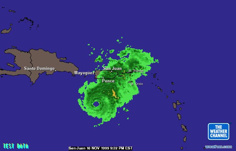
Attached file (14A.jpg) below shows 'Lenny' approaching Puerto Rico
and the Virgin Islands. Explains why winds haven't started yet.
Herman
|
| - Evening is falling... |
|
|
...
Darkness set in around 17:45 this late afternoon and the thunder and
lightning are quite heavy to our South and Southeast.
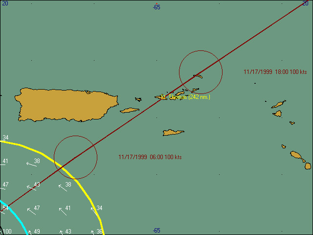
The eye is forecast to come right over St. Thomas tomorrow morning at 10:00. That is, if the storm stays on the forecast track! One way or the other, it's going to be very windy!! See attached file below. Many yachts left yesterday for Virgin Gorda Northsound (BVI). Looking at the attached graphic file, the BVI's are going to be experiencing hurricane force winds as well!!!! One Local radio stations is playing local music, another is on-par;
talking about the upcoming storm where people can call in.
Current weather in St. Thomas (on
South side, overlooking Crown Bay Marina and Water Island):
Wind: S - 1 kts.
Amazingly, the wind is still very quiet. Hardly a breath of air
is stirring the leaves.
Local weather man on the radio states that the wind should start to pick up in about 2 - 3 hours. Thunder sounds like the Navy has resumed it's usual bombing practice of the island of Vieques. Just had "Last Supper" (;-) Thank the gods for a microwave oven. Time to check the 20:00 intermediate advisory. See if 'Lenny' is still on track. Herman
|
| - Rains started... |
|
|
...
The first heavy rains started this afternoon around 15:30. Just
installed the shutters and disconnected the downspouts.
Time to take some more "Before-the Storm" pictures.
Herman
|
| - First rain band |
|
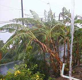
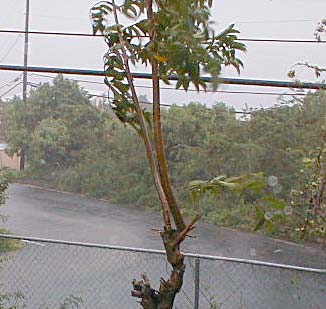
Well the first rain band passed through. It was 15 min of very heavy rain. In that amount of time 4 in of water was washing down the road and I'm loosing my first banana tree. (see photos 24k) Good luck to all, Max |
| - 1:00 and preparations continue |
|
Government let schools and government workers out at 1pm. Here at the University classes will be held until 4pm. The library is covering stacks but students are still here using it. At home (Brewers Bay) we're putting up plastic on the OTHER side and moving things that we don't usually move since it usually hits from the other side. Last I heard from the higher-ups, they understand the winds to start at 8pm and the 'cane is headed for direct landfall here between 2am and 2pm. I didn't see that information in the weather service reports, but there's lots of time for change too! Linda Barr linda.barr AT uvi.edu |
| - Preparations |
|
Good morning. Hurricane Lenny is bearing down on P.R. and the US Virgin Islands slightly faster than before. The VI Port Authority has closed the harbor to all vessels coming in over 200 gross tons. Two cruise ships have made it in but I'm not sure how long they will stay. All vessels over that size must leave by 8 pm. The Governor has activated the National Guard and a listing of hurricane shelter locations and opening times has been posted in the local paper (Daily News). Last night, the gas stations were virtually empty but they have long lines now. Some are going about their normal business. I observed concrete being poured, blacktop put down, and workers clearing grass on the roadsides! Makes me wonder where the priorities are sometimes. No rain this morning but we will see the outer bands late this afternoon. Curfew has not been set yet but will probably be around midnight. My preparations are far from over but I hope to be finally ready by midnight. So long for now. Dave |
| - Update |
|
governor Turnbull has declared a State of Emergency as of 8AM for the Virgin Islands . Today will be a regular work day for Government employees and ask all to secure their workplace before leaving today . He said this is a very serious situation .The two statements seem to contradict each other..I just heard that there are over 50 boats still in Christensted Harbor St. Croix ..here on St Thomas Crown Bay is empty and very few boats anywhere around Charlotte Amalie ..I'm on the west end near Fotuna Mill and heard that this is worse part of St. Thomas to be on ..oh well I'm packing to move anyhow...so have lots big garbage bags and putting everything in them..I'm going now to VITEMA meeting and will update www.onepaper.com/reporter ..we are also making arrangement with alternate servers so we can stay online during and after the ..also try to set up live cam.. |
| - Big Eyes... |
|
|
...
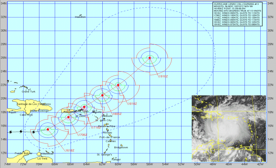
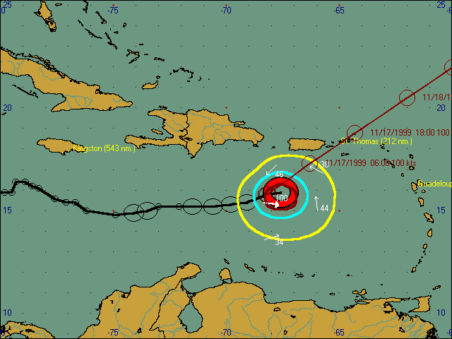
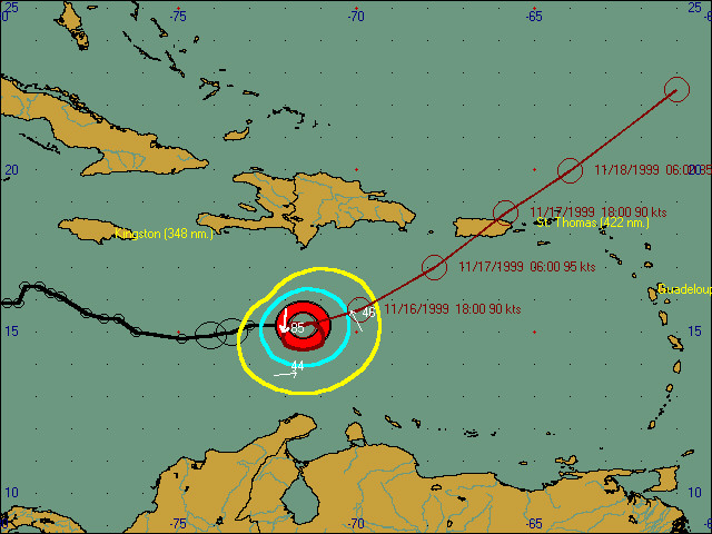
As local residents are looking with big unbelieving eyes towards the west, as hurricane "Lenny's" BIG eye is watching the NE Caribbean islands. The 05:00 discussion indicates the weariness the NHC must be feeling
of the fickleness that these kind of storms exhibit.
Apparently the latter must have been the case, since this morning's
advisory package clearly shows the pressure has dropped and the windspeed
is back up again. The eye has an
amazing 45 nm diameter!! It is not
visible on satellite imagery since it is covered by high clouds.
The wind is kept at an initial intensity of 85 kts but the Hurricane Hunters found flight level winds of 109 kts in the SE quadrant on their 03:07 mission. The NHC mentions that their 05:00 wind speed "may be a bit conservative". Not good. And sadly, then there will always be people that blame the NHC for "errors"
in their forecasts. How can they talk about errors, when all the
NHC is trying to do is make sense out of the 'chaos' that Nature's weather
shows.
Gorgeous sunset this morning in St. Thomas. Now (07:45), overcast
with low, middle and high clouds. Surface visibility still excellent
as St. Croix is clearly visible (+/- 35 miles distance).
Time to get the dinghy lifted out of the water. Herman
|
| - SeaCaribe's Weather WebPage |
|
http://home.talkcity.com/HurricaneAlley/seacaribe/ |
| - Calm... |
|
|
...
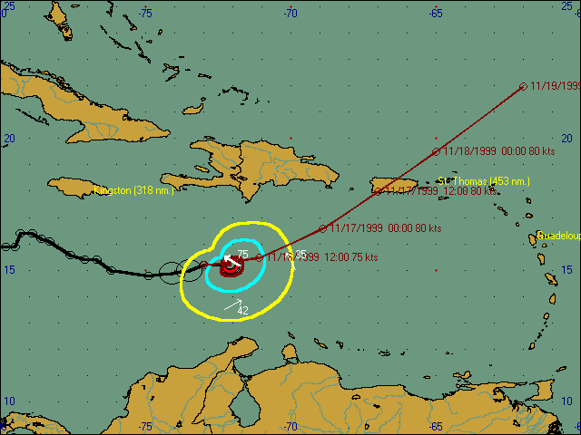
A nice quiet night in St. Thomas with just a little sprinkle once and awhile out of some clouds that seems to hover above the islands. Gone are the 'angry' racing clouds that could be seen yesterday over 'Mountain Top'. As of the 02:00 advisory (11/16), 'Lenny' is re-intensifying
and the 23:00 forecast track is shifted slightly to the West from the previous
(17:00) advisory.
MAIN question again is how is Puerto
Rico's mountain ('El Junque') going to influence 'Lenny's' track??
Wind:
SSE - 3 kts.
Back to bed. Herman
|
| - Lots of Rain |
|
1909, November 12-13 Tropical storm passed off northwestern corner of Puerto Rico in a WSW to ENE direction. ...1942,November 4 Tropical storm apparently developed just off southeastern Puerto Rico and crossed the northeastern part of the island in a ESE to WNW direction. ...1984, November 6-7 Tropical Storm Klaus passed just between Puerto Rico and the U.S. Virgin Islands in a SW to NE direction. ......some history....VITEMA was the calmest place I visited today, they are having an easier job this time because many thing put in place for Jose are still available.Heard a lot of anger from people around , almost like how dare a storm come here now..I talked to Col. Walker this afternoon and he was concerned about people making preparing for the storm and that they may put it off because of rain, but said we will not have a break from the rain before this storm,like we have had with most. After the 5pm they told me it will probably hit a corner of PR them over Vieques to St. Thomas and them St. John..but it is another wait and watch..it a compact storm so a little change can make a big difference..also didn't get the impression they were getting much comfort in the decrease in winds. I'm attending the VITEMA meeting at 10 am and will email again..The rain is a big concern at VITEMA.Donna |
| - St. Thomas Tonite |
|
...The timing is amazing. Everyone I speak with is shocked and disgusted. According to the 5pm, we are officially under a watch. Folks are rather annoyed, but beginning to pay attention. The streets are once again crowded and busy, but the air this time is full of slightly amused disgust. Me too. It couldn't have come at a more inconvenient moment as I am scheduled to put my cats on a plane Wednesday and fly to the States on Friday. Ug. Just what I needed ;-) And the sentiment is echoing Hull Bay road where the sound of nails and generator tests begin to fill the evening, all under a light rain and a behr> |
| - Lenny looms! |
|
The 4 pm EST advisory reinforced the earlier projections which has caused St. Thomas to get motivated. This is good news as even the procrastinators like myself are taking this one more seriously. Wind speed has diminished but that could change rapidly although not forecast. Hurricane watches have been posted and the local forecast shows hurricane conditions by Wed. early afternoon. The wind field has expanded to 145 miles (tropical storm strength) from the earlier 85 miles. Incredible amounts of rain appear to be associated with this system also. It is raining on St. Croix now and the Doppler shows the creeping closeness of the first outer rain flows. Puerto Rico these islands are in for a flooding and sliding 2-3 days. Not good at all. The cruise ship schedule, incredibly, is still intact for tomorrow. Cancellations are in for Wednesday though. I believe they will change Tuesday as it doesn't seem like there are many escape routes with the way a storm can alter it's direction. Jim Cantore of The Weather Channel was just on and many here wanted to know if he was going to come down and do a live report!! The laughs drowned out the TV. Dave |
| - Hurricane Lenny |
|
Just when I actually thought we were in the clear, along comes tthis guy! A compact storm at this time but could and should get bigger and stronger over the next few days. The current weather here is Partly sunny, humid and the seasappear calmer than they are supposed to be. I was out on a powerboat yesterday and it rained the whole afternoon. The seas were not bad at all although we were in the shadow of several islands. We have had enough rain though. The ground is saturated and we will definitely have flooding and mudslides if a direct hit or near miss occurs. Not many are taking precautions yet. I think they still don't believe it or are too stunned. Several sailboats are already heading south for safer anchorages. I'm sure the visiting cruise ship schedule will be altered. The port could possibly close as early as Wednesday although Thursday is a better bet. I have not heard any real news from government sources yet although that is not their fault as I was busy. As I have stated before, this hurricane season has been most unusual and parts of it have not conformed to previous experiences. I hope we all learn from these situations as we never know enough about the weather and it's fickle properties. Dave |
| - Uhoh!!.... |
|
|
...
"From Tropical Depression to Hurricane status in 6 hours." Other storms probably look with a little envy at 'Lenny' for pulling
this feat off so quick (One can hear them say: "Lenny
is going places. What a promotion!!"); but for us mere
mortals this stunt is rather horrifying. Especially since the 17:00
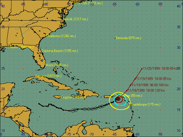
forecast track places the center just 50 nm NW of St. Thomas on Wednesday
Nov.
17 (!!) at 14:00 LT (Local Time).
Disbelief is rampant in the local marine community. Comments ranging
from "But we're supposed to be at the end of the
hurricane season", "It can't keep moving
East all the time", "The charter season
is starting" to "I can't deal with
a hurricane in November" were heard throughout this afternoon.
Haven't listened to local radio this afternoon but do hope that the
rapid promotion of 'Lenny' receives the attention that it soo deserves!
It will be interesting again, to say the least. Herman
|
| - Sandwiched... |
|
|
...
And once again, Nature demands our attention. Just when local people thought 1999's hurricane was over, here comes Tropical Depression 16 from the West and heading East!!! The local forecast for the upcoming days has more rain in store for Puerto Rico and the Virgin Islands. The islands can't absorb much more rain as the grounds are already quite saturated. Especially PR can't handle the forecast influx of water! It's rivers are getting close to overflowing their banks. Here in St. Thomas the grounds can't cope with much more water either, so it looks like the coming rains will have the potential of causing some land (mud) slides and will definitely close local schools; as this seem to be the rule whenever it rains. The NWS forecaster from PR, "Weather Summary for PR and the VI" (http://iwin.nws.noaa.gov/iwin/pr/summary.html), quipped this morning that he is collecting wood materials for his 'Ark'. Let's hope he has the proper building and environmental permits and doesn't break any "Protected Species" regulations. ;-)
------------
Barometer has been dropping slowly for the last two days. Right
now, the pressure is 1007.1 mb (29.74 in.) and still dropping.
Herman |
Older reports have been moved to another page
| Back to top | Home | Hurricane Guide | QHWRL | 1998 Season | 1997 Season | 1996 Season | Pleas for Help |