![[IMG: Luis; Credit: Norm Nelson, Bermuda Biological Station for Research - http://www.bbsr.edu/Weather/]](http://www2.gobeach.com/luis5.gif)
|
The Caribbean Hurricane PageUpdates from the Islands- - St.Maarten/St.Martin - - |
More recent reports can be found on another page
| - La Samanna, Baie Longue |
|
I heard from a reliable source that La Samanna will be closed till January 8! They had extensive beach and landscaping damage * ** *** Gert van Dijken ( gert AT vandijken.com ) **** The Caribbean Hurricane Page - http://www2.gobeach.com/hurr.htm |
| - Status from Marigot (fwd) |
|
More from the French Side. Note that the airport they mention is the 'little' one on the French Side, not Juliana Airport. * ** *** Gert van Dijken ( gert AT vandijken.com ) **** The Caribbean Hurricane Page - http://www2.gobeach.com/hurr.htm ---------- Forwarded message ---------- Date: Fri, 19 Nov 1999 18:24:36 EST From: BetsyWemyss AT cs.com To: gert AT gobeach.com Subject: Status from Marigot We were able to get through by telephone to Marigot. Our friends in Marigot say that the electricity is coming back in Marigot. They still have no tap water. They said that the electricity poles in Grand Case are down and in the streets. They confirmed that the airport road is flooded. - Betsy Wemyss |
| - Arbor Estates, St Maarten (fwd) |
|
News from Arbor Estates, close to Cupecoy Beach * ** *** Gert van Dijken ( gert AT vandijken.com ) **** The Caribbean Hurricane Page - http://gobeach.com/hurr.htm ---------- Forwarded message ---------- Date: Fri, 19 Nov 1999 16:19:42 -0500 From: Pat Nelson <cameo-homes AT mindspring.com> Subject: Arbor Estates, St Maarten Reliable source reports that some glass doors blown out. At least one villa on far side of lane lost roof. We are owners of Villa #4 and have lost glass doors on top and middle floor, others have also. As far as I know, all guests are okay, and have been shuffled to undamaged units, although this is not first hand info. pat nelson |
| - hi gert wanna help |
|
|
Dear Gert,
Hi iam mailing you
from concordia,spring on the french side of the island, everything is okay thank
god electricity is on, water don't know yet besides that everything is
allright even in the heart of marigot around the government building( the
mairies) there was some water in the morning but at present everything is clear
and the businesses have little bit of water in other words minimum damage
nothing to really worry about at present, hope there are no heavy rains which
seems likelyin that case we'll have to wait and see. take care bye sunil
|
| - Lenny |
|
Just spoke with my maintainance man. lives in point petite. The road around the runway at Maho was washed away. emergency road opened through the airport to get to Beacon Hill. Lots of boats sunk in the lagoon. only military planes landing. |
| - Bel Air /LittleBayHarmony/ |
|
|
Relatives from St.Maarten just called
me:Everything is alright in Bel Air /Littlebay.No serius damages at houses and
nobody is hurt.The Hospital is damaged.
|
| - St.Maarten |
|
Just spoke to my sister-in-law living at Port de Plaisance, Cole Bay, Dutch Side. Phonenumbers starting with a 4 are mostly working, numbers starting with a 5 not. Cell phones are mostly working again as well. She hasn't driven around yet (curfew), but the weather is ok for the last couple of hours. No wind, no rain. A few roofs from houses are gone. Most damage has been done by the water. Many coastal properties have suffered damage. Military planes are landing and taking off from Juliana Airport. The roof of the Immigration Building is damaged badly. American Airlines is supposedly resuming flights on Sunday. The road to the airport is apparently not damaged as bad as we thought. It is possible to drive to the airport. Power is expected to be restored soon. She has heard from a reliable source that there are 2 fatalities. Both were wandering outside during the storm. They have learnt their lesson from Luis and they will frantically try to get the island in shape as fast as possible. The island should be ready for tourists before Christmas. Thanksgiving is too soon to receive tourists So all in all, it is not as bad as we feared. There is a lot of damage, but the infrastructure seems to be mainly still in place, which will promote a speedy recovery. In general moods were pretty optimistic as well. While I was on the phone with her, she said that on the radio they just announced that the storm is officially over! * ** *** Gert van Dijken ( gert AT vandijken.com ) **** The Caribbean Hurricane Page - http://gobeach.com/hurr.htm |
| - information from relatives stranded on St. Marten |
|
Have spoken briefly to some relatives and they said they were fine. They have been moved to the Maho Hotel where there is some cell phone connection.They are without water & power and are receiving one meal a day. Some government official is to fly over the area today to assess damages. They are hoping that airport will be avaiable for use by Sunday! Wishful thinking??? I hope not. |
| - News from Island |
|
Just Heard News from Cole Bay/Pelican Key. Lost 2 waterfront villas, 3 more severely damaged. Darn Villa just below La Vista lost its pool. Caller was unable to go further to access damage due to curfew. |
| - Update |
|
|
Thank you for being on the internet for those of us who have
loved ones visiting St Maarten and, of course for the residents with relatives
and friends not on the islands.. Received call from Oyster Bay Resort and
daughter, Luan, states they are safe. The contact you have enabled
through the message board and updates has helped tremendously in easing the
stress associated with this hurricane and its effects. God
bless.
|
| - (no subject) |
|
Belair Beach Hotel reports that all guests are safe and there are no injuries.: |
| - damage assessment SXM |
|
Just spoke to SXM. So far they are still in the eye of the storm and people are venturing out to make some damage assessment. Compared to Luis there is apparently much less wind damage. The GEBE power lines for instance are still standing, which is a good sign. All businesses on the Pondfill, including the police officers houses are underwater by approximately 3 ft. The administration building has indeed lost part of it's roof, but everybody knows that already. The roof damage is apparently not that severe, but there is a lot of debris on the road. I was cut off but will keep on trying to get in touch again. Ivonne de Groot-Miami |
| - Communication with St. Maarten |
|
Just got off the line with St. Maarten. Simpson Bay area has severe damage. The lagoon is littered with sunken boats. They are trying to dig a trench between the sweet pond and the pond area so that the water flow will be directed towards the ocean and the pond can drain. Our friend had just taken off to survey the area. They have their warehouse on the pond and have 6 feet of water standing there. Will report back later when I have more eyewitness news to report. Thanks for providing this site. You do an invaluable job! Till later Ivonne de Groot-Miami, Fl |
| - Oyster Bay Beach Hotel |
|
Dear Gert, Two minutes ago I had a phonecall from the Oyster Bay Beach Resort in Oyster Pond. Everybody is safe. There's a small damage at the main building. But nobody can leave the resort because of the water on the roads. The resort is full with people. There's no water and no food anymore. We keep on praying for everybody. Best, henny ______________________________________________________ Get Your Private, Free Email at http://www.hotmail.com |
| - St. Maartin/Simpson Bay |
|
Just got off phone with son there. Wind has calmed down. Rain stopped as of 2 hours ago. 8 or 9 boats are sunk in bay. A lots of roofs are torn off, debris on roads making it impassible at this time. Curfew still in. All in all it doesn't look as bad as he thought it would. |
| - Early reports |
|
Well by some strike of luck I managed to get an early copy of what will be the 5 AM report and it appears LENNY is stationary with the eye stuck between SXM and St.Barths Central pressure is rising and eye is wobbling so this means WEAKENING Currently at 100mph sustained LENNY is a Cat 2 and it appears that this will continue My opinion from viewing sat images and weather pattern analysis - LENNY will remain stationary for the most part with slight drifting and it will DIE where is lies - right over SXM. At least most of the island is getting some relief as morning breaks, being pretty much at the edge of the eye. Remember please this is just my observations and personal opinions - NOT THAT OF AN OFFICIAL NATURE so dont hold me to it. |
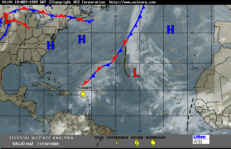
| - Why LENNY is stationary |
|
Here is a good overview image which shows the reason LENNY keeps stalling and why it is taking the "drift pattern" it has been following |
| - St. Maartin/ Simpson bay |
|
Just got off phone with my son there (11:20 central time). He said it had been very quiet there for 2 hours However, wind begin again blowing hard and now out of opposite direction and it is raining hard again. Water level is falling. That is all he knows for now because he can't get outside. It sounds as if eye has just passed. |
| - UPDATE |
|
Well, my cellphone is dead so I am now also not able to get in contact with the island until I recharge (those damned NiMH batteries). This should not take long. I have managed to call and confirm that at this time they are at the edge of the back half of the eye and basically re-entering the remainder of the storm. What little break they got while the eye just drifted over them is about to end. However, while LENNY was drifting slowly he has also weakened . Last report I received indicated the following EYE OF LENNY OVER ST. BARTHELEMEY IN THE NORTHEAST CARIBBEAN... AT 2 AM AST...0600Z...THE CENTER OF HURRICANE LENNY WAS LOCATED NEAR LATITUDE 18.0 NORTH...LONGITUDE 62.9 WEST...OR OVER THE ISLAND OF ST. BARTHELEMEY. OVER THE NEXT SEVERAL HOURS THE CORE OF THE HURRICANE WILL CONTINUE TO AFFECT THE ISLANDS OF ST. MAARTEN...ANGUILLA...AND ST. BARTHELEMEY. ST. MAARTEN RECENTLY REPORTED SUSTAINED WINDS OF 74 MPH AND GUSTS TO 104 MPH. MAXIMUM SUSTAINED WINDS ARE NEAR 110 MPH...175 KM/HR...WITH HIGHER GUSTS. SOME ADDITIONAL WEAKENING IS FORECAST DURING THE NEXT 24 HOURS.. HURRICANE FORCE WINDS EXTEND OUTWARD UP TO 35 MILES... 55 KM... FROM THE CENTER...AND TROPICAL STORM FORCE WINDS EXTEND OUTWARD UP TO 145 MILES...230 KM. THE LATEST MINIMUM CENTRAL PRESSURE REPORTED BY AN AIR FORCE RESERVE HURRICANE HUNTER AIRCRAFT WAS 978 MB...28.88 INCHES. What does that all mean? Lenny is wearing down, - he has slowed to a crawl, which is not good in terms of the time it will take to pass the islands, however, he has also lost a lot of his blast- weaker central pressure means weaker winds - and this means the wind coverage area has also decreased (storm is getting smaller to try and stay alive). It does also mean a lot of RAIN - so now the threat remains flooding/slides. |
|
If anyone wants to send me email which I can then get answers to from updates in SXM send it to my hotmail account - the other will deny access till I get the system up again. Hotmail is jlrdovale AT hotmail.com |
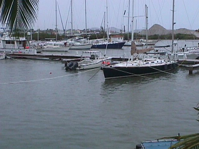
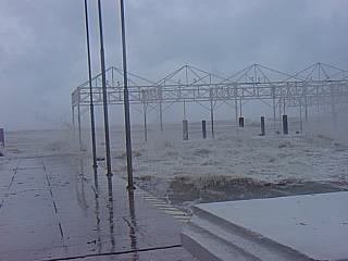
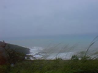
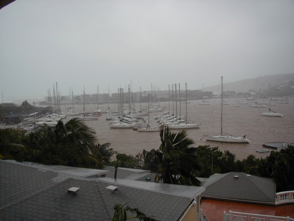
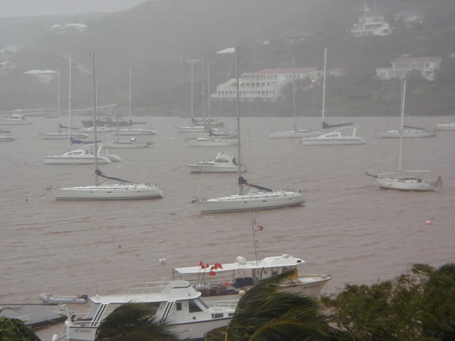
| - Simpsonbay Yacht Club- nice shot before the storm |
|
Nice shot of calm before the storm in the lagoon area around the yacht club (photgrapher was not venturing outside) Here is a shot of our office- before the storm- hopefully it survived although the water was rising early. Thats all I could get for now-- will try later for more |
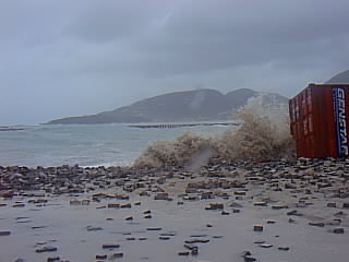
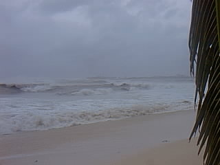
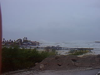
| - Photos |
|
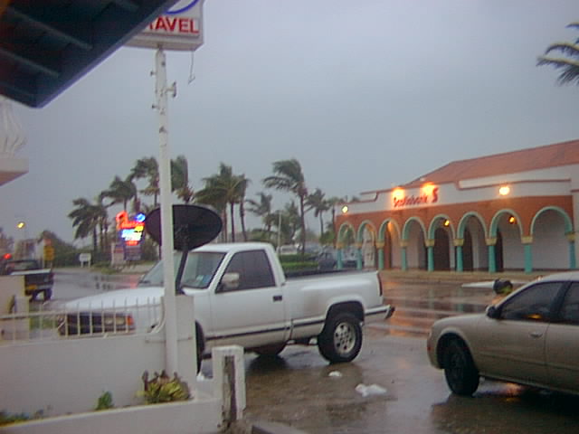
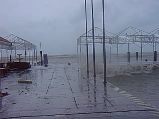
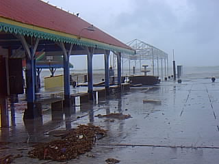
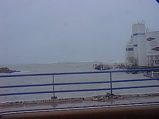
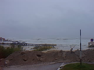
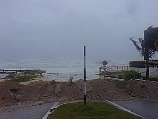
3 shots of more damage and water surge at the PORT Early shot of things in front of our office |
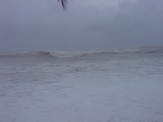
| - Photos |
|
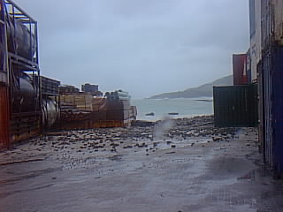
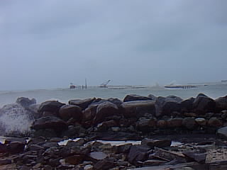
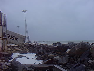
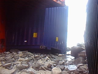
Breakwater - by Chesterfields Roll on Roll of Pier at Harbour Facility Containers Slipping into the sea at the Harbour Facility More containers |
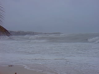
| - Photos |
|
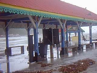
2 more of the AC Wathey pier and 2 of the tender landing at Bobby's Marina |
| - Photos |
|
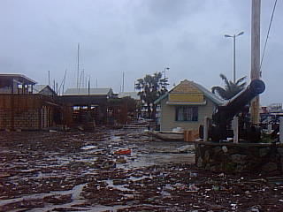
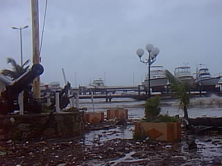
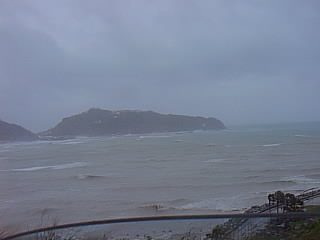
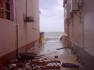
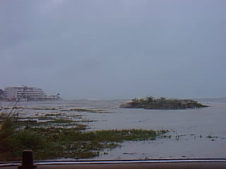
looking accross great bay harbour from DIVI area An alley way to the beach in Philipsburg (remember this is way early on) The last two are of the AC Wathey pier (small one in center of town) |
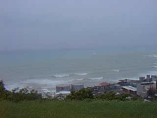
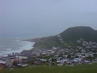
| - Photos |
|
These are simpsonbay beach, the power plant area in cay bay and the beach just below when crossing over colebay hill |
| - More from MAHO area |
|
These are all from the MAHO area again |
| - Photos |
|
I tried sending with HOTMAIL and no luck for the attachments so here goes First two shots are of indiana beach area looking towards pelican and also crossing the bridge the other two are of a temporary sand dune made to hold back flooding at the MAHO area road to Beacon Hill |
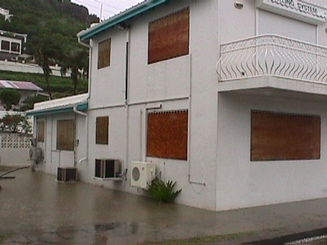
| - Here are some photos I received - this was before the big HIT |
|
indiana beach looking from airport blvd toward pelican - flooding ______________________________________________________ Get Your Private, Free Email at http://www.hotmail.com |
| - UPDATE FROM THE EYE |
|
Okay I have been receiving massive amounts of mail re: whats happening in SXM and whats up with our weather site so lets get the housekeeping out of the way here. 1. Our ISP has been shut down - our operations people did this because it was not safe to stay there- our building in in the Airport Blvd area and this is now flooded (the road is pretty much under water) and we dont want them risking their lives or any equipment for any reason. 2. The power has been out for some time and since JOSE we lost genset from operating it during the storm so we could not do this again. 3. I am physically not in SXM unfortunately - my partner and I were away on business and LENNY popped up - we do have contact with several sources including family and friends all over the island - when telephone contact is possible. As a result we have received updates from time to time while we track the storm from our location ------------------- UPDATE AS OF TIME OF THE EYE 1. Philipsburg is flooded and badly damaged from surge on the seaside 2. The new port facility which was under construction (a couple million) has sustained some serious damage 3. There were containers floating in the harbour early in the storm 4. The Great Salt Pond is overflowing and the water level has reached almost to backstreet 5. Reports have it that the government building roof is about to/or has lifted 6. The beac, bar, and road at the end of MAHO are all gone - leaving Beaconhill isolated 7. Pelican, Simpsonbay, Beaconhill, Cupecoy area are taking the brunt of the storm (or were when we got reports) 8. Most hotels have evacuated to upper floors to escape flooding problems and reports are that all people are safe and many hotels have power from gensets 9. Communications are messy- vey difficult to get to cell phones and landlines- No internet access is available at this time 10. French side reports some damage as well and flooding but so far also bearing the brunt of the storm 11. Have heard that Oyster Pond area was relatively okay- no boat problems there or anything 12. Have reports of serious flooding in the St.Peters, Saunders, LB Scott Road and Colebay areas 13. So far it appears there was one casualty - a Public Works employee this is still unconfirmed and was early on and due to landslide 14. One radio station was streaming local reports via http://www.korsou.com but I dont know if that was still the case as it was being done on phoneline and this may now be impossible 15. Some people in Beacon Hill reported that their roof was showing signs of weakening so they have opened their entire home to let the wind blowe through to save the roof - they are now bunkered down in concrete covered garage area 16. Phone lines and service from MAHO area all the way through Simpsonbgay (numbers with 5) is down - hard to reach them at all. Colebay is still reachable as is ECC cell (but difficult). No one with a telcel number that I tried could be reached - all I got was voicemails. 17. I got a report from someone working with a SPORTS BOOKIE place there they were open and taking bets - I could not believe it. I will not make comments on this because it infuriates me. They even had the nerve to ask me when I was gonna turn up the internet again. How compasionate! 18. Most tourist who have family there - if they know the tel no. Try calling - you may be lucky and get a call in and this will ease your mind - I know talking to my wife and son (4 yrs) made me feel a hell of a lot better - although I really feel like I should be there. 19. Anyone thinking of visiting- think again! We wont be ready for prime time for a bit so it would be best not to overburdon the system which will be in relief mode for a while 20. We have some pics of oyster pond - I will try to get this online somehow and let you all know later- we are getting info CIAO ______________________________________________________ Get Your Private, Free Email at http://www.hotmail.com |
| - News from the Atrium |
|
My wife just spoke to people at the Atrium Resort, located right on Simpson Bay Beach (Dutch Side). Right now there was hardly any wind. Aparently they are sitting more or less in the eye. But the wind has not really been a problem so far. It was more gusty then say sustained hurricane force winds. They are fully booked, but all guests are safe and sound. Phones are still working and they do have power (generator). The rain will/is more of a problem. Also the waves. Looking out of their window they can see that the Airport Rd. is under water right now. * ** *** Gert van Dijken ( gert AT vandijken.com ) **** The Caribbean Hurricane Page - http://gobeach.com/hurr.htm |
| - Fw: |
|
|
Hi Everybody
It seems like we are in for a loooooong
day. Lenny stopped about 60km west south west of us last night. We
have winds of about 40knots and some rain. At this stage they are
predicting the eye wall to pass over us late this afternoon. We will still
have storm conditions until tomorrow night. As you can see, we still have
power and internet so all is not so bad. The max winds of 135mph are still
to come. So far everything seems ok, all boats in Oyster Pond are still
floating. The south of the island is getting battered by the sea. It
looks like I will be busy surveying for the next few weeks.
That's all for now
Mary and Stuart
|
| - Current Weather Conditions |
|
[Thu, 18 November 1999 12:15 EST] - St.Maarten The center of Lenny is now very, very close to St.Maarten/St.Martin. Weather conditions at Juliana Airport, St.Maarten as of 11:36 EST: Wind from the SE (130 degrees) at 55 MPH (48 KT) gusting to 80 MPH (70 KT). That's not bad at all, not even hurricane force winds. Weird since the center is so close to the islands... Suprised though that we still get weather reports from St.Maarten (URL: http://tgsv7.nws.noaa.gov/weather/current/TNCM.html. Links to weather reports from other islands can be found on our 'Practical Guide' http://www2.gobeach.com/hurr3.htm * ** *** Gert van Dijken ( gert AT vandijken.com ) **** The Caribbean Hurricane Page - http://gobeach.com/hurr.htm |
| - Report from LIVE CHAT with someone in SXM |
|
According to this report the Governor has announced on radio that the brunt of the storm will be on SXM in about 45 minutes Currently they are experiencing a lot of heavy winds and rain- pouring rain. It appears local radio stations are still up and running and giving reports - this is a good sign. We lost the connection as our counterpart was on battery powered laptop and attempting to dial our international roaming numbers- he got disconnected. ______________________________________________________ Get Your Private, Free Email at http://www.hotmail.com |
| - Update from IDL reps (outside SXM) |
|
Okay here is what we know: 1. A lot of you are trying to reach our weather site http://weather.networkidl.net However this is on our local network and it was decided to shut it off to allow staff to go home safely and also to safeguard the network from damage. We have been monitoring the storm from our vantage point outside SXM. (currently we are in Albania) and we have also been in contact with a few of our people from time to time when telephone connections allow What we have heard so far (based on what they hear on local radio LASER101) is that the harbour and philipsburg sustained heavy damage from storm surge, and 25 ft waves. There are at least 20 containers which have washed into the ocean in the harbour area. Some may be afloat but many have beached themselves around the philipsburg area We also understand that there have been massive mud/land slides in the hilly areas and it is possible that this may have claimed at least 1 life. Additionally we understand that flooding is severe in all parts of the island but in particular the philipsburg area, belair area, and around the airport/colebay/simpsonbay area We heard that the sunset beach bar at the end of the PJIA (MAHO BEACH) is gone - washed into the sea. The beach and road there are totally impassable and 25 ft waves have been washing sand and debris up onto the end of the runway. One unconfirmed report indicated that there was even a vehicle which was taken by the waves and washed up onto the end of the runway in that area. There are also some small aircraft which may have sustained damage at that location. The telephone system is operational in some areas, although we were told that the Beacon Hill/Simpsonbay Area telecom system is totally down- inaccessible at this time We know from trying that cellular is difficult to reach also Reports from people in the colebay area around the yacht club were that water levels were extremely high. Unconfirmed at this time is the claim that the sea and the lagoon have joined in the vicinity of the ATRIUM hotel.We were also informed that the lower floors of the ATRIUM, ROYAL ISLANDER and ROYAL PALM hotels were evacuated due to the danger of the storm surge. We dont have any news from anyone on the French side of the island but early reports have it that preparations on that side of the island were slower in taking place than on the Dutch side. The last update we got was at 6AM this morning and it was reported that in the Colebay side the winds were minimal due to the aproach of the eye - howeverthe philipsburg area was still feeling heavy winds. At the same time SABA reported winds of 140mph but other than that we dont have much to go on. Here is one URL which we were given - we couldnt get it to work but aparently they are streaming Real Audio from LASER101 (local SXM station) via a phonecall. try it http://www.korsou.com We are still trying to establish contact to get more updates- for now this is all we have ______________________________________________________ Get Your Private, Free Email at http://www.hotmail.com |
| - 10am update on "Left-handed" Lenny |
|
|
Lenny is the "Hurry up and WAIT"
Hurricane. We have news that it has started to move from its stalled position
over SABA and is headed directly for St. Martin. So far no major problems on the
Orient / Cul de Sac side of the Frenchside. The water was cut off last night but
electric and phones are still up. My electric problem was a personal
"house" problem. We got it up and running at first light. Everything
is still green. No trees down. Lots of water. Getting bored. Will keep in
touch.
Elisa
|
| - sxm update 9pm |
|
The wind is starting to get serious now ! Gusts to 50 kts ? We lost water about an hour ago and electricity about 10 minutes ago. Scarey stuff considering I was here for Luis ! This one is stonger and moving at 9 miles per hour ? Heard about 3 deaths so far and 17 containers off the pier in Phillipsburg. Hope the system doesn't stall anymore than it already has and we are spared a major catastophy ! Hope my roof holds up ! Will continue to report on my laptop untill the phone lines go down. My hotel guest in Orient bay seem fine for the moment as well. Good Luck and Peace to all affected. Elisa |
| - UPDATES and IMAGES |
|
For those hurricane watchers and others wanting updates from St.Maarten here is some information current weather, local feedback, chatroom and images blow by blow http://weather.networkidl.net the ticker at the top takes you to chatroom check out recent images as it passes updates are continuous chat room is now open JOIN US! ______________________________________________________ Get Your Private, Free Email at http://www.hotmail.com |
| - Update |
|
|
it is now 1.25 pm in pelican, st. maarten. winds
are picking up. we had some pretty strong wind gusts. the sea is getting rougher
and more milky, which normally means that more and more sand is being turned up.
from the lower area at pelican i know people that have moved, since the waves
started being high pretty early already. they did not want to risk the real
thing when the hurricane comes. Kim sha beach has already erosion. i saw that
the little wooden deck from Indiana Beach closest to the sea was already being
destroyed by high waves. It also looked like the pier from Pelican on which the
Edge (boat to Saba) docks was already damages. will keep you
informed.
|
| - hurricane Lenny |
|
|
hai, this is joan. i live in st. maarten in the
area pelican. it is now 8.45 am and we are experiencing very heavy rains and
heavy lightning and thunder. the wind is not too bad yet. the sea is very rough,
and as far as i know, the hurricane is not even here yet, just the outer bands.
we are fine concerning the flooding at my house since i live higher, but i am
worried about the wind. especially since this one comes from a completely
different directions than what we ever had before. will try to keep you updated,
as long as i have power.
|
| - Lenny and St. Maarten. |
|
|
Hi,At this moment it is still rather quiet here in
St. Maarten. We will be under a curfew as of 1200 today. Sometime towards the
same time the winds should start picking up and the whole scenario will last
around 12 hours of which the hurricane conditions may take 4 to 5 hours. Also we
are now being warned that residents of low lying areas, including a number of
beach front properties and hotels, should relocate themselves to higher ground,
as it is expected that the South and West sides of the coast will come under a
storm surge 4 to 7 feet above normal.
Although I have not been outside Beacon Hill area
where I live, but it appeared yesterday that most precautions were or were being
taking. Later on this morning I will go towards Philipsburg and check out what
is going on. Until then best regards.
Matthew
|
| - Tuesday Nov 16 - Residents Prepare |
|
ST. MAARTEN - The Lt Governor has called on residents to take the necessary precautions under a Hurricane Warning effective 5pm. Her Majesty Queen Beatrix and Prins Claus still plan to visit the island, but after the hurricane has passed. She wants to show her solidarity with the people of St. Maarten. Schools are closed tomorrow Wednesday. The Ports Authority was busy making preparations today for the Roll-On Roll-Off Pier, the new Cruise Pier under construction and the Capt. Hodge Wharf. Two cruise ships were in port today and the tourist enjoyed their stay. They were able to visit some of the beaches, take an island tour and shop on the Fronstreet - business sector of Philipsburg. The Lt Governor stated that residents should prepare for flash floods similar to Hurricane Jose. Business and home owners could be seen hammering away closing up their premises. It seems that others will do so early tomorrow morning. The Governor called on grocery store owners as well as hardware stores to remain open late Tuesday evening allowing residents and visitors ample time to prepare for Hurricane Lenny. It is expected that a curfew will be implemented at midday on Wednesday or some time in the afternoon. This will be made known once an update has been given on the direction of Lenny early Wednesday morning. A contingent of Dutch Marines arrived on the island Tuesday to assist with the manning of Emergency Centers. The weather at the moment: 22.00, a calm evening with a little breeze, no rain. The Princess Juliana International Airport remain open for air traffic. Roddy Heyliger Communications Consultant - Caribbean Information Provider Email: medprocomm AT email.com sabagis AT hotmail.com Visit St. Maarten/Saba Web Sites: www.mrstm.com, www.mssaba.com For Caribbean Vacancies visit: www.caribbeanjobfair.com |
| - Lenny |
|
|
Actually we do not want to talk about this system,
as now it appears to come too close for comfort. The predicted track brings the
system late tomorrow afternoon about 60 NM to the NNW of St. Maarten, which will
give us hurricane force winds from the fringe of the center of the system. The
Lt. Governor in his short radio speech announced the hurricane warning for St.
Maarten from 1700 hrs today. This entails that everybody needs to finalize the
preparations asap. The shops will be allowed to remain open until 1200 tomorrow,
but this may be put at an earlier time depending on the course of the system.
From time of closure of business there will be a curfew until after the storm,
time to be announced, but assume until Friday sometime during the
day.
Will await tonight 1100 update and see what still
needs to be done. No general evacuation of tourists has started, but that looks
impossible anyway with Puerto Rico airports being closed, so they will have to
live through the experience, which of course does not fo good to the future
tourist trade.
Regards,
Matthew.
|
| - LENNY |
|
|
Well, it appears to be coming closer and closer to
St. Maarten. As of this afternoon 1400 hrs there was still some 440 nm between
our two positions. However, the track appears still to go slightly to the North
of us. This to be between 60 and 80 NM, which would bring us on the verge of
hurricane force winds. Timing seems more favourable than in the past, at least a
number of day light hours before the system is supposed to reach 20.0 N and 62.5
W, being the the NNE of St. Maarten.
Another favourable thing appears to be the forward
speed, at present about 16 knots, so the system will not bother us too long, but
still it remains a dangerous situation. There may be massive rain fall so that
again flooding can and most probably will occur.
The largest problem is the tourism industry which
again gets an upper cut, as we again stand to loose tremendously economically.
Cancelled flights, cancelled cruise ships, stranded people, no shopping,
possible curfew, etc.
The weather at this moment is cloudy, no rain as
yet, the winds seem to be from the SE, but that will change during the evening
and night when the wind will turn to the South.
We'll just hope for the best and St. Maarten stands
strong and tall as usual.
Matthew
|
| - Monday Nov 15 - Keeping an Eye on Hurricane Lenny |
|
ST. MAARTEN - The core members of the Emergency Operations Center (EOC) met today monday to discuss the preliminary track of Hurricane Lenny which is now back down to a Cat 1, before that Lenny was a Cat 2. Expectation is that we will get some weather from Lenny based on its preliminary track. Rough seas, rain and maybe some tropical storm winds. The EOC will meet again at 2pm on Tuesday. Local radio stations talkshow hosts have been chit chatting about the hurricane and some have been providing news coverage as well. Residents are paying keen attention as Lenny tracks across the Caribbean Sea. Roddy Heyliger Communications Consultant - Caribbean Information Provider Email: medprocomm AT email.com sabagis AT hotmail.com Visit St. Maarten/Saba Web Sites: www.mrstm.com, www.mssaba.com For Caribbean Vacancies visit: www.caribbeanjobfair.com |
| - LENNY and St. Maarten. |
|
|
The whole situation is becoming slightly tedious
towards the end of this year. When is the present hurricane season finally
finished? We are close to the opening of the tourist season, early December, but
these Tropical nuisances keep popping up. Professor Gray is now two storms off
in his predictions and he might even be off more on the amount of severe storms.
The only thing what Lenny has been doing is gathering more wind speed. Another
thing is the direction of the system. Tracking East is such an easy remark,
checking the positions since the system became named unti lnow only indicates
the system going South of East or in a direction between 95 and 100 degrees
True.
Predictions of course tend the system to change
course towards the North during the coming 24 or 48 hour periods. This could
bring the system close to St. Maarten. The predicted position for Thursday at
02.00 am is 19.5N/63.5W or about 85 Nautical Miles NNW of St. Maarten. This
actually is too close for comfort again.
If so required the island will of course be
properly prepared for whatever comes our way, but economically we will suffer
again due to loss of arriving passengers by air and by cruiseships.
Regards,
Matthew
|
| - Sunday Nov 14 Mixture of Weather |
|
ST. MAARTEN - The wind direction has shifted to the South West since Saturday. Small aircraft traffic at the Princess Juliana International Airport, have to land from the Simpson Bay Lagoon side of the runway. On a daily basis we have been having rain which is keeping the island nice and green. However, the ground cannot cope with so much rain. Today Sunday, the beaches were packed with people, an indication that the high - tourism - season is beginning as the number of visitors to our Friendly shores increases as the weeks go by. Preparations are well underway for the visit of Her Majesty Queen Beatrix (Dutch Queen) and Prins Claus on Wednesday evening. On Thursday November 18 she will visit various projects and meet with government officials. Roddy Heyliger Communications Consultant - Caribbean Information Provider Email: medprocomm AT hotmail.com sabagis AT hotmail.com Visit St. Maarten/Saba Web Sites: www.mrstm.com, www.mssaba.com For Caribbean Vacancies visit: www.caribbeanjobfair.com |
Older reports have been moved to another page
| Back to top | Home | Hurricane Guide | QHWRL | 1998 Season | 1997 Season | 1996 Season | Pleas for Help |