|
|
|
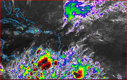
- Warning: The ITCZ is above Zero Degrees
|
- By Ian Martin Borde <readkrox51 at gmail.com>
- Date: Wed, 17 Apr 2024 20:47:24 -0400
|
Weathermen and The People of Paradise,
The Weathermen and the PANS System has gotten it 112.5% CORRECT !!!!!!! Those Familiar with me know, I won't add Anything. What is SIGNIFICANTLY GREATER ,..., is they got it in the stipulated Hazard Warning Time, ...
I will love to have a NORMAL 24 hours in NORMAL Days,...
[Quote; by 20th Century Thinkers] "The absence of religion, does not mean the absence of 'Morality'".
GOD is Blessing,...
|
|
- Unpredictable 2nd Tropical Wave - 36hrs. -
|
- By Ian Martin Borde <readkrox51 at gmail.com>
- Date: Sat, 30 Mar 2024 15:17:57 -0400
|
Happy Easter! Holy Ramadan! People of Paradise, ...
Before that but in 36 hours we will know exactly what a TW has in store for us, for a day and a half. It's Unpredictable Now because, it's in the middle of the jet stream.
Pause for a Meditation Quote; "While the culminating climax of Hard Work is Celebration Things like Fasting and Praying and Giving Alms and Meditation, Is BECAUSE, you can only build as HIGH as YOUR FOUNDATION".
G O D ! Please Bless
|
|
- 2024-03-07th Thu. - 1st True Tropical Wave -
|
- By Ian Martin Borde <readkrox51 at gmail.com>
- Date: Thu, 7 Mar 2024 08:21:13 -0400
|
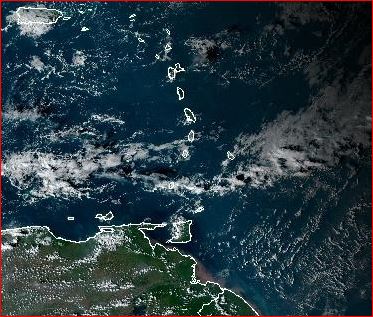
Precipitation mostly in South.
Winds mostly in Tobago.
If it lasts till tomorrow midday? North has something to worry about.
Expect anything,...
|
|
- Mon. 12th - Tue. 13th 2024 - Carnival - 'Sacred & Profane' -
|
- By Ian Martin Borde <readkrox51 at gmail.com>
- Date: Thu, 25 Jan 2024 23:04:15 -0400
|
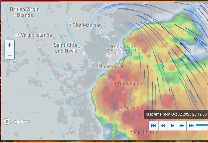
People of Paradise,
Weatherwise: We are in the middle of the 5th 'Tropical Winter Trough' (TWT_#5)!!!
Because these new climate change deadly troughs
need more analysis. For now this January 25th 'TWT' can be called the 4th, 5th, 6th 7th, 'TWT'?
(Remember; What the first one did?) "Don't throw 'Caution' to the Wind",...
The attachment is from 1982 and Peter Minshall and Peter Samuel.
Remember! The reason for Carnival is 'Pray and Fast' for Easter.
GOD Bless

|
|
- 4th Tropical Winter Trough (instant - 72hrs.) -
|
- By Ian Martin Borde <readkrox51 at gmail.com>
- Date: Mon, 8 Jan 2024 02:02:39 -0400
|
Happy New Year's Happy Carnival Season People of Paradise,
Sahara Dust is stopping the 'TWT'. But, the SAL is Dispersing,...!!
Winds = 18 - 38 kmh. Waves = above 6' ft. Water = about one inch per hour. ( mostly less in the early stages, ...!!!).
Trinidad and Tobago has LOST
A GIANT Spirit in a Humble Body, ... , that leaves an indelible LEGACY, . . .
Rest in Perfect Peace, Honourable Basdeo Panday

|
|
- All Clear, from Midday, Christmas Day,... -
|
- By Ian Martin Borde <readkrox51 at gmail.com>
- Date: Mon, 25 Dec 2023 03:13:18 -0400
|
All the BEST! For the Season , . . . . . . , People of Paradise.
[EXERCISE CAUTION: Because it's Winter.] But, There should be an "All Clear, including Rivers", from post-midday, Christmas Day.

|
|
- 3rd Tropical Winter Trough -
|
- By Ian Martin Borde <readkrox51 at gmail.com>
- Date: Wed, 20 Dec 2023 17:20:55 -0400
|
|
G O D Bless
|
|
- 2nd Tropical Winter Trough (TWT) in 36 hrs. -
|
- By Ian Martin Borde <readkrox51 at gmail.com>
- Date: Tue, 5 Dec 2023 17:54:10 -0400
|
There is a type of Monsoon Trough in 36 hrs.
Remember!!! "What the last one did?"
|
|
- con Condolencias Nuestras -
|
- By Ian Martin Borde <readkrox51 at gmail.com>
- Date: Thu, 23 Nov 2023 17:45:58 -0400
|
|

|
|
- Centre of Cirulation - 2:00pm. - Jamaica -
|
- By Ian Martin Borde <readkrox51 at gmail.com>
- Date: Fri, 17 Nov 2023 14:48:02 -0400
|
I'm not writing much.
This calls for action.

|
|
- !!!! Jamaica, Haiti, Turks and Caicos - Standing By !!!! -
|
- By Ian Martin Borde <readkrox51 at gmail.com>
- Date: Fri, 17 Nov 2023 02:05:28 -0400
|
[Just Remember]: Everything will be WET after !!!!
Standing By, (Helping Already) !!
|
|
- !!!! 98L and 2nd. Tropical Winter Trough !!!! -
|
- By Ian Martin Borde <readkrox51 at gmail.com>
- Date: Thu, 16 Nov 2023 01:54:35 -0400
|
Folks,
- Calling for Help!!!! Is NOT ONLY for Casualties. B u t ! For Those Attending Casualties,....
- It's NEVER TOO LATE ; You can still give them a DIGNIFIED DEATH,... Amen !
It's a Bucket Brigade.


|
|
- Winter Caution: Haiti & Windwards -
|
- By Ian Martin Borde <readkrox51 at gmail.com>
- Date: Fri, 10 Nov 2023 19:28:16 -0400
|
A ?Monsoon? Trough is threatening the Windwards. Impacting already!! "I will like to be the first to call them a Tropical 'Winter' Trough, ..." It is not a wave and the ITCZ is not present.
Whatever it is, (proven already in T'dad), in my estimation, ... ,
... , First Responders , like Lifeguards, should be made aware!
Waves, Winds and Water will be above normal, ... !!!
Separately for Haiti, judging from the Season, While you desperately need hillside vegetation, you had enough for the Season, not counting 'earthquakes'. !!
- Schub Deewali! Jai Shri MatamaLaskmi !

|
|
- All Clear (T&T) -
|
- By Ian Martin Borde <readkrox51 at gmail.com>
- Date: Sat, 28 Oct 2023 07:45:00 -0400
|
|
President's Botanical Gardens


|
|
- Complacency and Conquest -
|
- By Ian Martin Borde <readkrox51 at gmail.com>
- Date: Thu, 26 Oct 2023 20:27:20 -0400
|
This has nothing to do with 'All Clears' and Emergency Procedures ! But we are in :- The Middle of The Tropical Wave.
And,
This is the last Friday in the month!
[My Take]: Walk to the Corner.
God Bless

|
|
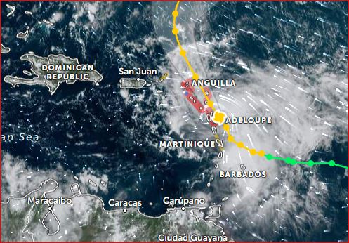
- Centre of Circulation - 1:00pm. - Guadeloupe -
|
- By Ian Martin Borde <readkrox51 at gmail.com>
- Date: Sat, 21 Oct 2023 13:44:36 -0400
|
|
|
|
- Standing By and Alert for 36 Hours !!!! -
|
- By Ian Martin Borde <readkrox51 at gmail.com>
- Date: Sat, 21 Oct 2023 00:57:55 -0400
|
Standing By !!!!

Standing By !!!! |
|
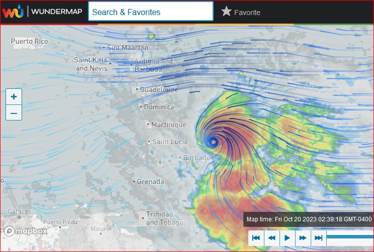
- EVACUATE - Landfall 02:00am Bridgetown - EVACUATE -
|
- By Ian Martin Borde <readkrox51 at gmail.com>
- Date: Fri, 20 Oct 2023 03:01:39 -0400
|
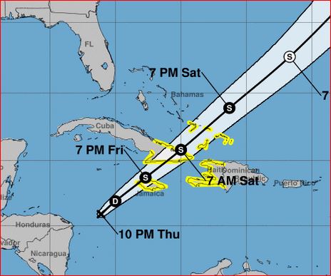
Victims in Paradise,
For; Barbados, St. Vincent, St. Lucia & Tobago, Winds: 8mph. - 16mph. Seas: Well Over 08' ft.
Precipitation: Soon-to-be Catastrophic for a day and a half.
E V A C U A T E !!!!
All Coastal Areas (Lesser Antilles) !!!! & 200 yards from Waterways.
D'ont Go Out ! Stay Indoors ! Drink at Home.
|
|
- Time Lagging !!!! -
|
- By Ian Martin Borde <readkrox51 at gmail.com>
- Date: Wed, 18 Oct 2023 06:00:22 -0400
|
Fellow Folks of Paradise,
Don't forget Tobago's Carnival 2023, . . . .
Weatherwise; "Imagine in Friday Traffic out-of-Port of Spain, water seeping into the running board and gushing outside, while the grandmother is at home by herself with your infant".
[My Take]: The Tracks of 'Phillipe' and 'Tammy', are a
Merciful reminder of 'Irma' and 'Maria'.
In this era of roving on Mars with real-time visuals. Time is Lagging, 'Too Far Behind', in
Analysis, Prevention and Preparedness. Which leads to suffering in Mitigation.
In other words, "This is not good enough".
God Bless, You Do the Rest, ...
|
|
- Barbuda 'Impact' 8:00pm. -
|
- By Ian Martin Borde <readkrox51 at gmail.com>
- Date: Mon, 2 Oct 2023 20:51:15 -0400
|
Fedaw, Jane, Barbara, (just to name a few of thousands), .... Beloved Dave and Hard-Working Gert and Isabel, Tortola and Virgin Gorda, Turks and Caicos and St. Marteen!
This reminds me of some 'Domino' addicts. When I was in the other islands. It reeks of 'Incompetence' !
As far south as Trinidad, I woke from sleep. To very few moments of Silence in between about an hour of Thunder.
[Quote]: "It is BETTER to Err, on the Side of Caution!"
Tomorrow afternoon a lot of people are going to face the axe.
|
|
- "What to Do?" -
|
- By Ian Martin Borde <readkrox51 at gmail.com>
- Date: Sun, 1 Oct 2023 22:08:06 -0400
|
It's Obvious !!!!! What to Do. 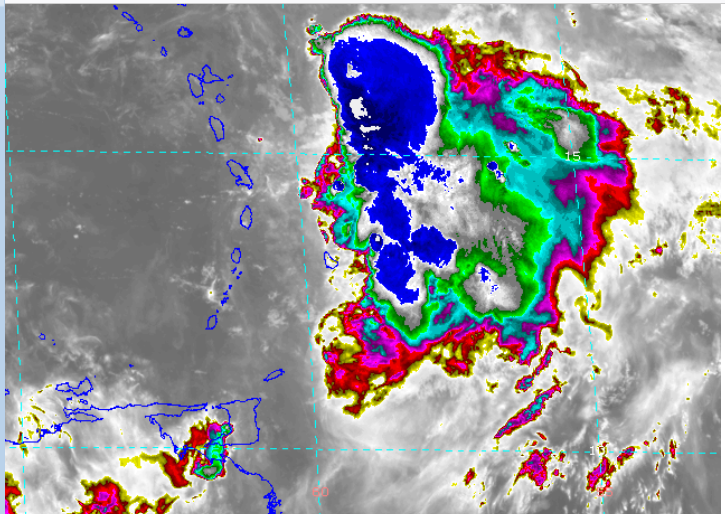
|
|
- Bad Weather Ongoing and Continuing -
|
- By Ian Martin Borde <readkrox51 at gmail.com>
- Date: Mon, 25 Sep 2023 13:11:21 -0400
|
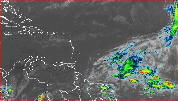
People of The Windwards,
As in the case of NorthWestern Trinidad Thunderstorm activity for the next seven (07) days !!
Donate Volunteer Help Recover

|
|
- 27th - 29th October - 2nd. Annual 'Tobago Carnival' - 2023 -
|
- By Ian Martin Borde <readkrox51 at gmail.com>
- Date: Tue, 19 Sep 2023 04:25:23 -0400
|
Good Day, Good Everything, 'People of Paradise'
Weatherwise: Non-Cyclonic RAIN in 24hrs. - 36hrs. Most of the Lesser Antilles.
I try, So I'll temper down my feelings about Climate Change. Among two other more PRESSING Global Concerns. and just say, I hear you. But I can only do so much. Eg. In T&T, if the Heat Advisories continue. I suspect for the first time in the rainy season. Authorities will have to ration - WATER - .
Quite a few capable Protegees have arisen. GOD! Please Bless

|
|
- ABC's & Lesser Antilles - STANDING BY -
|
- By Ian Martin Borde <readkrox51 at gmail.com>
- Date: Tue, 22 Aug 2023 05:20:47 -0400
|
Call for HELP !!!
Stay Indoors
&
In Shelters.
Standing By
|
|
- Chere Haiti, Sauvez-Vous Memes, Notres Freres, ... -
|
- By Ian Martin Borde <readkrox51 at gmail.com>
- Date: Mon, 21 Aug 2023 04:41:42 -0400
|
Gentes de Les Dieux !!!!
Les Ventes = Plus de 85kmh. Les _Ondes_ = Plus de 2 - 3 Metres La Plieu = Plus de 5 - 7 ins. chaque heure.
Pretez-Vous en La Benediction de Dieux

|
|
- 2023 - Tobago October Carnival - 2023
|
- By Ian Martin Borde <readkrox51 at gmail.com>
- Date: Sun, 20 Aug 2023 06:18:02 -0400
|
People of Paradise !!
- Second (2nd.) Annual - - - - Tobago Carnival - - - - - - October 2023 - - -
Calendar of Events, ... :
G o d ! Please Bless, ....


|
|
- Whiteout ! -
|
- By Ian Martin Borde <readkrox51 at gmail.com>
- Date: Sat, 19 Aug 2023 14:50:59 -0400
|
The Center of Circulation, (Yes! Center!), (with Moisture 250 nautical miles around it), ... and with Winds over 35kmh.
Passed Over Barbados at 08:00am and thereafter. And, Passed Over The Grenadines 12:00pm and thereafter.
? More than a 'Tropical Depression' ?
It doesn't take Much? One can simply look at the birds and skys, ...!!!
Peace

|
|
- Well Done, Stephen! -
|
- By Ian Martin Borde <readkrox51 at gmail.com>
- Date: Tue, 15 Aug 2023 05:48:05 -0400
|
Over to You, . . . . But, Supporting, the People of Paradise.
Alham Dulah
|
|
- Things to look at.
|
- By Stephen Abouhamad <stephen_abouhamad at hotmail.com>
- Date: Mon, 14 Aug 2023 23:12:06 +0000
|
|
Michael Abouhamd
Date: 14/08/22
Trinidad and Tobago
Good afternoon Stormcarib Family.
There are two areas in the Atlantic that needs to be monitored. Will give an update soon. Today in Trinidad we had a humid day with mixed weather conditions. Looking forward to a settled night.
Best Regards,
Michael Abouhamad
|
|
- Centre Landfall - 6 1/2 Hours onwards -
|
- By Ian Martin Borde <readkrox51 at gmail.com>
- Date: Tue, 8 Aug 2023 16:48:26 -0400
|
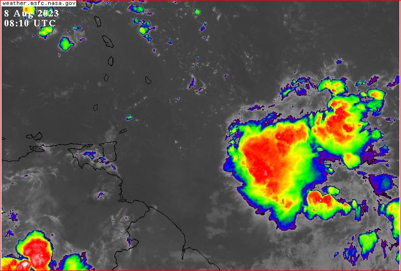
People of Paradise,
As you can SEE in the Attachments;
The Centre has Circulation. The Centre is Hovering over 10N. The Centre will TouchDown in 6 1/2 Hrs. thereafter, ...
Winds South of the Centre are only round 10kmh. Winds North of the Centre are peaking at 25kms. (to Dominica). Landfall may be like two years ago. (Over Tobago and South of Grenada).
That is unless it STALLS !!!! The probable Depression has a over 1,000 nautical miles Tail.
God Bless
|
|
- Life - Money - Dominoes -
|
- By Ian Martin Borde <readkrox51 at gmail.com>
- Date: Tue, 8 Aug 2023 04:30:58 -0400
|
|
I told You So.
|
|
- the Peak of the Season -
|
- By Ian Martin Borde <readkrox51 at gmail.com>
- Date: Fri, 4 Aug 2023 03:53:24 -0400
|
People of Paradise !!
I don't pay attention to normal hurricane paths, history and averages. That is during this New Era of 'Climate Change', ... !!!! It's my ?Guess? however, we are approaching The Peak of The Season !
Complacency Kills !!!! Get it Right !!!!!!!
Furthermore, ... The Peak of The Season doesn't necessarily mean for me, a larger number of 'storms' !! For me it means, 'One' is Going to Hit !
'D' to 'I' - 'Dorian' to 'Ian' and down to 'M' and 'Maria'. They are more Devastating.
Get Ready


|
|
- (Leewards - Beware) - ALL CLEAR - South of Martinique inclusive -
|
- By Ian Martin Borde <readkrox51 at gmail.com>
- Date: Tue, 25 Jul 2023 01:23:22 -0400
|
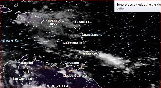
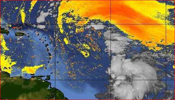
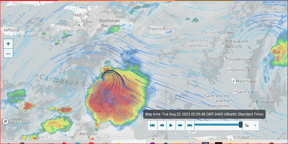
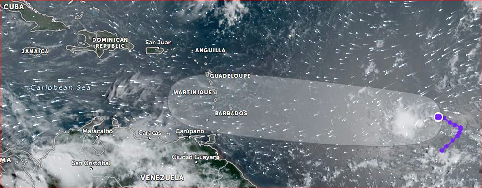
People of Paradise,
- Apparently 'Protegees' are coming forward, ... -(I'm too old for this and to be up all night). - "Leewards we are talking about a TW - with two inches of rain an hour, not longlasting, .... - Precipitation and Moisture south of Martinique, negligible for 3 - 5 days.
Continue Praying People of Paradise

|
|
- Get Your Shipping Done this Weekend -
|
- By Ian Martin Borde <readkrox51 at gmail.com>
- Date: Sat, 22 Jul 2023 10:20:10 -0400
|
This is NOT Going to Be an Easy Season ! I knew that since May. But now the People who Guide me. Are expecting maybe three Impacts on the Lesser Antilles, ... !!!!! (That includes 'Depressions').
Whatever You do , . . . , STAY CALM , . . . .
Don't make a bad situation worse ! Comply ! Don't complain, criticize or condemn.
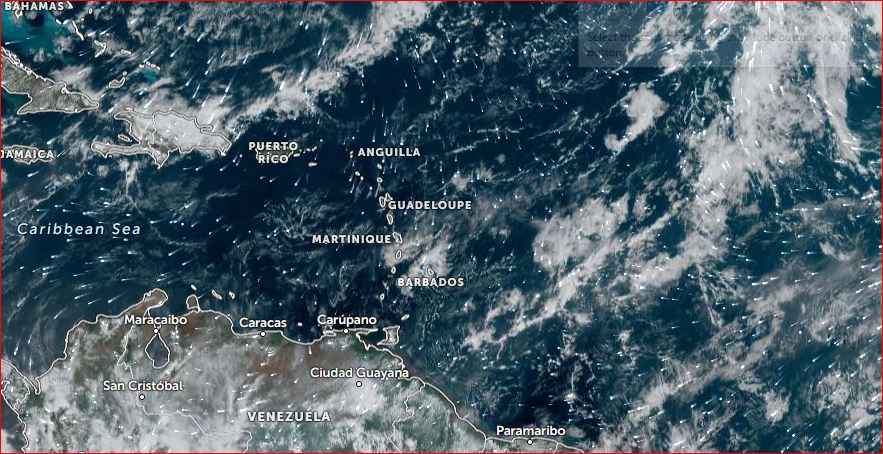
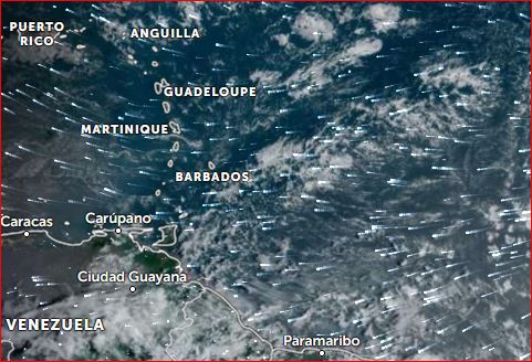
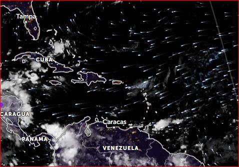
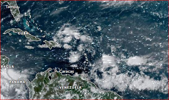
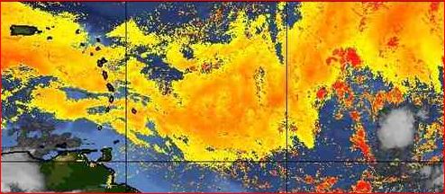
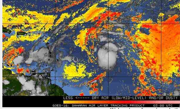
In the Centre of Circulation, winds are already over 35kms an hour!! In a 450miles (North-West Segment) Radius, winds average 15kms. an hour. If one looks at the 'SAL' image attached? The SAL is LESS around the Lesser Antilles, ...? Winds off the East Coast of Trinidad are 20kms. an hour.
- Cut (weak) Branches. - Clear Drains, ... - Empty Catchments. - Avoid Traffic. - Store Water. - Laise, Laise, Laise, with better equipped people.
Lastly: (Permit me Gert & Dave?), By the very MINIMUM, T'dad can be divided into, ... NORTH - SOUTH - TOBAGO -
God Bless us with younger Correspondents! Willing to Give. Till it Hurts, ...
|
|
- Whatever You Do , ... , Don't Panic ! -
|
- By Ian Martin Borde <readkrox51 at gmail.com>
- Date: Tue, 11 Jul 2023 11:30:19 -0400
|
Call for Help.
Besides the North East Marine Earthquake, ...
At 11:00am. today, the 'Axis' of the TW is over Martinique.
Call for Help !!!!
|
|
- Interval of 'All Clear', except Shipping -
|
- By Ian Martin Borde <readkrox51 at gmail.com>
- Date: Sat, 24 Jun 2023 01:57:32 -0400
|
We, the People of Paradise, are a 'Bucket Brigade' ! Nuff Respect !
There is definitely room, much needed room for 'Respite'. Before the next 'Hazard' comes along. Do Well, with it !
One must give way to Local Authorities, at all times. (Anything else, is too much confusion during a 'Hazard'.)
In addition: Being a 65 year old, who spent his time near or in the sea. Essential Services can ship and travel safely.
I am in AWE and Admiration at this 'Act of God', called stormcarib.com
From one Protege to The Next
|
|
- 50W. - 'all clear' - and - Dominoes -
|
- By Ian Martin Borde <readkrox51 at gmail.com>
- Date: Fri, 23 Jun 2023 09:51:40 -0400
|
- Those most in Danger - The authorities - Who seem to be my Proteges
Are raising questions of what determines my all clear? Ans. "The answer is 50 West."
In this case, not just 'Cindy'. But, the tail of 'Bret', and, Moisture and Dry Air, Between us and 50 West.
I am sure Martinique will agree, there is no all clear at this time.
|
|
- N O , All Clear -
|
- By Ian Martin Borde <readkrox51 at gmail.com>
- Date: Fri, 23 Jun 2023 02:55:52 -0400
|
Definitely, No all Clear.
We need Damage Control Information ONLY and URGENTLY.
STAY at HOME or SHELTERS.
The forthcoming situation is second degree BAD.
|
|
- Standing By !
|
- By Ian Martin Borde <readkrox51 at gmail.com>
- Date: Wed, 21 Jun 2023 12:42:22 -0400
|
People of Paradise,
You are handling it well, (without me directly).
I'm posting to say: The weakest Point I see. Is That, Seas will be Rough. Not just from now. And 'Bret', ... But for larger vessels.
For close to two weeks. (My take?)
Islands dependant on other islands in the same Nation. Might have problems by the time of the second storm. Direct Hit or Not !
Last thing we want, ... , Dear God, ...
Standing By

|
|
- Another Bret
|
- By Adesh Nanan <adeshcnanan at gmail.com>
- Date: Mon, 19 Jun 2023 18:06:56 -0500
|
Dear Gert Every time Bret comes around there is severe flooding in the southern part of Trinidad. Bret was here in 2017 and there was severe flooding in the southern part of the island. We are praying that it will pass us by this time,since the island already had severe flooding from a tropical wave. Although the forecast track is more to the north, feeder bands could affect the island and lead to more flooding....we must be on our guard
Dr Adesh Nanan |
|
- 100% - Get it Right - 100% -
|
- By Ian Martin Borde <readkrox51 at gmail.com>
- Date: Tue, 13 Jun 2023 03:55:09 -0400
|
Our Dear People of Paradise,
- Self - Safety - Survival - & - SUCCESS -
I am having a Time, .... Eating Mangoes , .... I take back all I said about Climate Change
and dry, smaller fruits. Boy! These mangoes Succulent ! And, "Yes!" Time to start back planting 'Pineapples'. Oranges are now 'King Orange'. I have the river. But not enough space for watermelons. Besides, they are Very susceptible to flooding, ...
Now! Back to the Caption, ... The Mastery of Success is not being a Celebrity. But how well you cope under 'Stress' and 'Bounce Back'. It's about, Airways, Breathing and Circulation. Oxygen in Your Blood, ... ! It's about 'making do' with what you have. Ask the military. It's not about 'Money & Politics'. Politicians manage Money. And money can't help you breathe and eat and walk and sleep. Far less Work. Survival is 'Hard - Work'.
We needed to Survive last Year. Not just with what became a Hurricane. But for the entire Season, - the Entire Trinidad and Tobago -
Get it Right ! with Godspeed


|
|
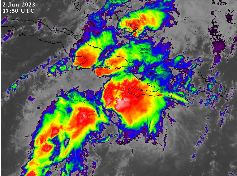
- "Haiti?", You're NOT Forgotten!!! -
|
- By Ian Martin Borde <readkrox51 at gmail.com>
- Date: Fri, 2 Jun 2023 14:12:44 -0400
|
|
Haiti, is what got me started.
|
|
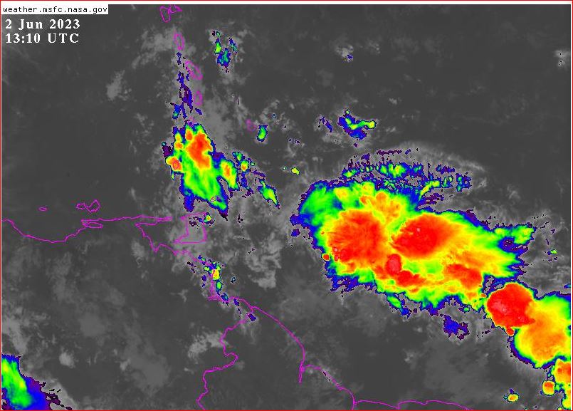
- Volunteer! and Be Strong ! -
|
- By Ian Martin Borde <readkrox51 at gmail.com>
- Date: Fri, 2 Jun 2023 10:36:57 -0400
|
Welcome Everyone! My Isabel and we people of Paradise,
Here we go again.
Waves: Manageable. Visibility: Poor. Winds: 12 - 21 kms. an hour. Precipitation: one (01") inch an hour. (Slow Moving, ....)
[Aside]: Imagine? I can't do this anymore. But my Network is Available. It's a Possibility?
GOD! Please Bless
|
|
- 'Stationary' -
|
- By Ian Martin Borde <readkrox51 at gmail.com>
- Date: Sat, 27 May 2023 08:02:55 -0400
|
It's Stationary !
As I learnt from following Dr. Masters? It's either, going to 'Disperse'. or, it's going to intensify. There was circulation just before 40W.
If the 'Lesser Antilles Rule' comes into play, ... !!!! We will know tonight !
Sorry for the 'extra' standby, ... That can be taken to mean? We need to be 'extra' prepared.
Let's Hope it Disperses.
God Bless
|
|
- Touchdown Imminent (Standby) before 04:00am. -
|
- By Ian Martin Borde <readkrox51 at gmail.com>
- Date: Sat, 27 May 2023 00:47:33 -0400
|
At time of Posting: People of Paradise,
A tropical wave with 'formative' Circulation less than 700 miles away. With 22kms. an hour winds off East Trinidad and Tobago. and, With 30kms. an hour winds off Barbados. (same distance). Will touchdown before 04:00am. Lasting into Sunday, ... Precipitation for EVERYBODY including the Leeward Islands, w i l l be, more than one inch an hour at central impact. [Fact]: Even though carelessness is involved. One inch can kill.
"There is Nothing more Important. Than 'Life' and Death !"
Standby GOD Bless
|
|
- 36 - 48 Hours -
|
- By Ian Martin Borde <readkrox51 at gmail.com>
- Date: Thu, 25 May 2023 22:22:43 -0400
|
|
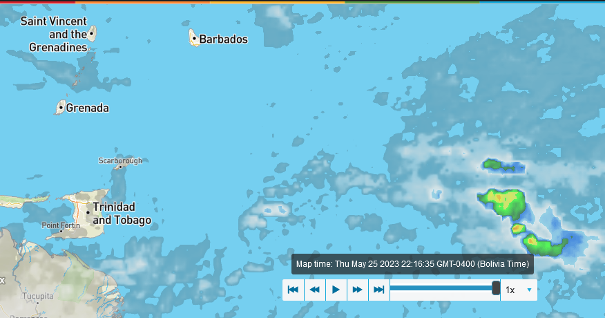
|
|
- Bad News -
|
- By Ian Martin Borde <readkrox51 at gmail.com>
- Date: Tue, 23 May 2023 22:25:42 -0400
|
Dear Observers in Paradise, Please get on Board, .....
Ohhh-kay !!!!
We just had our third Tropical Trough. Which was our first Tropical Wave!! The next tropical Wave in 4 - 5 days Time, will be our first Tropical Wave with Circulation. That means; Higher than Normal Seas! Maybe over 2" ins. of Precipitation !!!! (an hour, definitely from start to finish)!!!! Breezes around 20mph. Localized areas under 30 mph.
This is Dramatic, But quite Obviously, We had to get to the Point ! & It's after 10 o'clock in the night, a work night. With a work day tomorrow after Sunrise.
Gee !!! Get on Board, ... Your effort will be MINIMAL, .... EVERYTHING is Set up already for YOU. 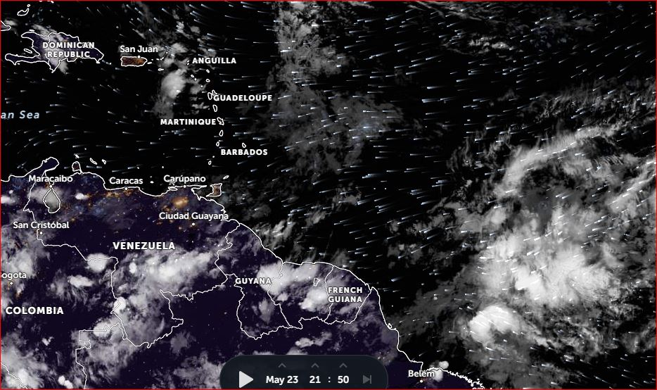
|
|
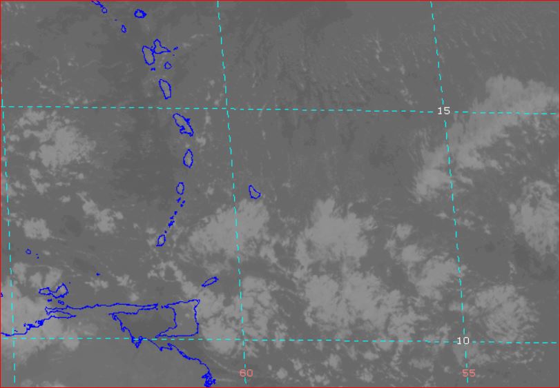
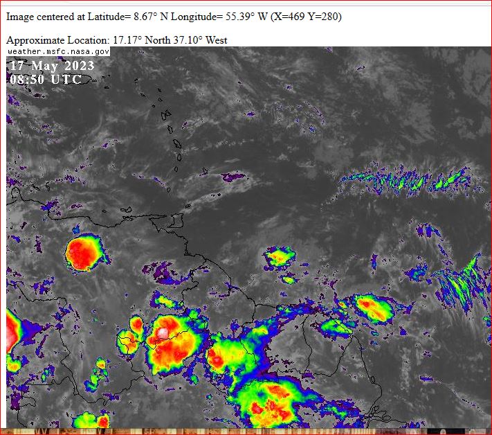
- ? Third 'Tropical Trough' in less than 36 hours ?
|
- By Ian Martin Borde <readkrox51 at gmail.com>
- Date: Wed, 17 May 2023 06:37:03 -0400
|
Good Morning, People of Paradise! Good Day !
Just quickly about Flora and Fauna. For a number of reasons, I am greatly tempted to use the term 'Global Warming', instead of Climate Change. The fruits are drier and smaller. The Sahara Dust, The out-of-timing Crises and oscillations, The seaweed, LAST but NOT LEAST, the Water Situation, ...
Enough about 'dry' fruits, ... It seems that for the New Moon on Friday 19th. 2023. The third in the first set of tropical Waves for this season. Will reach the Latitude of Trinidad and Tobago.
Nothing Hazardous, but stranger things have happened!!!
The wind shear is present but not as strong as last year. The SAL as mentioned before is a TOTAL MESS. The barometric pressures are not conducive for cyclonic precipitation.
Everytime I get into a work groove and leave other things to be. Undercurrents steer me back to what needs attention, ...
However, the Pandemic is 'officially' over.
God Bless 
|
|
