|
|
- - - 2011 Hurricane Season - - -
|
- Wild Wed
|
- By "Val Donaghue" <lowcalval at earthlink.net>
- Date: Wed, 9 Nov 2011 12:29:42 -0400
|
|
Hi All,
Well..we are having quite a bit of weather here in
Cruz Bay...VERY dark, like it's night... rain, although not heavy right
now, THUNDER...flashes of lightning....(I'm terrified by both) ..my cats
and I did hide in the closet for a couple of the bigger rumbles, and it looks
like more is on the way... The temps have fallen as well...the towel brigade is
laid out in the kitchen...the electicity has flickered a few times...oh
no...more big rumbles..time to re-treat !
Lowcalval
|
|
|
- Super Sunday
|
- By "Val Donaghue" <lowcalval at earthlink.net>
- Date: Sun, 23 Oct 2011 12:59:15 -0400
|
|
Greetings all !
It has been a LONG time since my last post...my
keyboard lost it's 'period' ( laptop menopause ? tee hee) BUT after going
through KBRT ( keyboard replacement therapy) has regained
it's function ...
The weather has been absolutely gorgeous here on St
John for the last few days.. Blue, blue, blue skies, pretty, puffy clouds, lush
green foliage everywhere !
Saturday Bootcamp class was a toasty one with
not much breeze, but it was my first class that I could run with my 'team' after
having broken my ankle...yipee !!! After class we went
over to the 'No Fleas Please' flea market to help support the ACC ( Animal Care
Center) here in Cruz Bay...GREAT event, very well organized, lots of great stuff
for sale at the right price...huge turnout...The ACC has an online magazine that
is very well done...check it out ! Later, it was
off to the beach... Trunk Bay for lunch and sun. The water is still
soooo warm and the temps were quite warm. Driving back along North Shore
Rd everything was so gorgeous it made your heart swell. mmmmm. Coming back
to town, we stopped at the Ice Cream Place/Bar to help our friend ease into his
new job as ....well....drink master/ice cream provider.. : )
Today, we went for a nice hike from town, onto the
Lind Point Trail, over to Salamon Beach then to Honeymoon, then up the trail to
the road and then...Tamarind Court for breakfast...We DID earn it ! And
NOW....Football from the Intex inflatable pool, with TV hung from the side of
the house...yup that's right....
Enjoy !
lowcalval
|
|
|
- Sunday
|
- By "Val Donaghue" <lowcalval at earthlink.net>
- Date: Sun, 11 Sep 2011 08:21:26 -0400
|
|
Good morning all,
Well, here in Cruz Bay, on STJ, we really did
not have much of anything from Maria...a little wind, a few gust and only some
moderate rain. Nothing really heavy or extreme...We're spared again
! It is cloudy and a little breezy here this a.m., but in looking at the
radar and water vapor images it should seem like we are getting poured on
! Nope, just clouds for now .
Today is the 10th year after the tragedy of Sept
11th and there is much media coverage of the events and ceremonies
occuring today. Keep this in your mind today whatever your day may
bring.
lowcalval
|
|
|
- non-storm
|
- By "Val Donaghue" <lowcalval at earthlink.net>
- Date: Sat, 10 Sep 2011 16:32:01 -0400
|
|
Hey all,
It has actually turned out to be a beautiful,
breezy day here in Cruz Bay...not much rain or wind... go figure... All is
well
Lowcalval
|
|
|
- Maria
|
- By "Val Donaghue" <lowcalval at earthlink.net>
- Date: Sat, 10 Sep 2011 10:38:52 -0400
|
|
Good morning all,
A rather sunny and breezy morning here in Cruz
Bay...we were able to get Bootcamp in at 9:00 am ( yup, with me on
crutches leading the way ! ) with only 1 quick bit of rain and now the sun
is back out again. The National Park building is closed and ferries
are starting to move to the creek. I'm not sure if ferry/barge
service is still running ? They were reportedly were going to suspend
service this a.m. Or if the Airport is still open...All in all
things are pretty quiet around town...we DO expect heavy rain and gusty
winds, but the towel brigade is ready !!!
Stay dry and safe : )
lowcalval
|
|
|
- what
|
- By "Val Donaghue" <lowcalval at earthlink.net>
- Date: Thu, 8 Sep 2011 20:03:31 -0400
|
|
Okay... all of a sudden we had aHUGE downpour,
THUNDER..all kinds of stuff...All at the same time I decided to take my 'maiden
voyage' to the Marketplace, with my cast boot and crutches...I thought, well
there are flat walking areas and elevators...did NOT anticipate the
slippery tile and rubber crutch tips....got a few errands done and used a
shopping chart..that was conveniently located on the level I was on..to get to
my Suzuki. I was laughing and cursing all at the same time !
Let's all keep an eye on Maria...she looks like a
'cryer/rain-maker' and a fast mover and shaker..........."there's something
about Maria " (West Side Story )
Pain 'relief' and football on tap !
Enjoy!
Lowcalval
|
|
|
- Labor Day holiday
|
- By "Val Donaghue" <lowcalval at earthlink.net>
- Date: Mon, 5 Sep 2011 08:04:44 -0400
|
|
Good day all....
The past few days have been quite warm, VERY sunny,
but yesterday we had a nice, drier breeze, thanks to Katia passing well to our
North.. We now have Invest 95 out to our East to keep an eye
on This system is sitting quite low at the time and is rather large in
size...will keep an eye on it...High surf advisories in effect, also from
Katia, I'm sure surfers are going to get some action out
there!
Today is a holiday in the USVI and PR...Labor
Day...and the 'unofficial' end of summer in the the
States...Unfortunately, TS Lee wil be putting a damper (pun intended ) on many
holiday BBQ's and get togethers...
Today there is a 'parade' out in Coral Bay and
supposedly the car races are going to be banned this year...we'll
see. As for me, it will be lack- luster as I am hobbling
around on crutches, with a heavy cast boot on my left leg... a little injury
while training a client at the gym...boo hoo ! The Islands are
definately a challenging place to have limited mobility...lots of hills,
no sidewalks, lots of stairs, no elevators except for the Marketplace...I
have a hard time having to SLOW DOWN ! Me no likey :
( My husband had to kind of 'carry' me to the beach...how
humbling ! Oh well , it could be worse : )
Have a great day !!!
lowcalval
|
|
|
- Super Saturday
|
- By "Val Donaghue" <lowcalval at earthlink.net>
- Date: Sat, 27 Aug 2011 12:34:20 -0400
|
|
Hi All !
Yes, so far it is a super Saturday...it
wasn't too hot for Bootcamp class this a.m. we actually had a breeze and a
gentle rain shower to cool us off ! This time of year alot of residents
take their off Island adventures...so I'm cat sitting for a few of them...Early
on, on one of these cat care posts, one of my charges zipped out the door before
I had a chance to even think...and Miss Margaret has been on the loose
since...but she is a wanderer and does this often according to her
'parents'...and just now I had to chase and fetch my friends dog...Rayne...who
was spooked by people at her cottage ! BUT, it is sunny and not too
humid.
My husband left for Mass. yesterday to help his
parents secure their beach house...people saw him on the ferry and asked why he
was leaving and he said he was chasing the storm and didn't get enough of
Irene the 1st time and wanted a 2nd chance with her ! tee
hee...Despite all the hype, Irene does seem to be loosing some energy (maybe
from my husband chasing her ! ) We'll see...
Have a great day !
lowcalval
|
|
|
- Post-Irene
|
- By "Val Donaghue" <lowcalval at earthlink.net>
- Date: Wed, 24 Aug 2011 06:48:43 -0400
|
|
Good morning all,
We have had continued off and on rain, wind,
thunder and lightning from passing bands of Irene. It really is a large sized
storm. Phone service (land line) service it still spotty and c-phone service is
improving as is Internet connection. This a.m. I am now seeing a little
sun to the East...we'll see it it stays ! Hope everyone in her path stays
safe !!! Oh...and how about the Earthquake on the East coast of the US
?
Have a good day
lowcalval
|
|
|
- Wind, rain, noisy night; still continuing
|
- By crabbys at earthlink.net
- Date: Mon, 22 Aug 2011 08:17:11 -0400 (GMT-04:00)
|
Wind gusts continue here up between 25 to 30 knots from the tail of now
Hurricane Irene.  Many people are without power and internet; most damage is
limited to vegetation (tree limbs; we lost several banana trees).  It looks
like there are at least three boats on shore in Coral Bar -- right near Island
Blues.   Don't know how hard they came up.

Overall, most folks came out okay; the storm is still continuing this a.m. with
wind-driven rain and wind gusts.  So far, we've picked up 5.7 inches of rain
from Irene.
|
|
- Still have power; gusts here now up to 35 knots
|
- By crabbys at earthlink.net
- Date: Sun, 21 Aug 2011 20:36:29 -0400 (GMT-04:00)
|
Well, we decided to board up the east and south facing windows, and that was a
good decision.  We continue to get rain along with wind gust reaching 35 knots
-- not as impressive as Bethany Man, who is getting 55 knot gusts, but pretty
alarming when you think that something could potentially be flying your way in
it.  We still have power out here in Carolina, although it did sputter a short
time ago -- really just about hanging in there.
Our neighbor, who is visiting, stopped by for dinner.  He came wearing a rain
parka and carrying and umbrella, and he was still wet.  Only walked a few doors
down.

I am on dial up at the moment.  We just cannot get through via ATT.

Hope things don't get much worse.
|
|
- rain, some wind, power loss and internet issues
|
- By crabbys at earthlink.net
- Date: Sun, 21 Aug 2011 18:24:20 -0400 (GMT-04:00)
|
We've really been having trouble connecting to the internet; there are power
outages around the island, but we still have power here in Upper Carolina
(Coral Bay area). Rain in buckets.

East Ender reports that they are now getting blasted from the Southeast as the
storm moves through.  Glad she has her storm panels up and dinner prepared --
in case the power goes out.

Bethany man says he's had gust of over 50 knots at his still from the northeast
and torrential rain.
He hasn't have power for some time.  Mammy Peaker also lost power awhile back.

Gifft Hill man says it's really gusty there, lots of rain, about a 1/2 inch an
hour.

I will post as long as I can access the internet.

Be safe.
|
|
- Emailing: 004 (2)
|
- By "crabbyswatersports" <crabbyswatersports at earthlink.net>
- Date: Sun, 21 Aug 2011 13:53:14 -0400
|
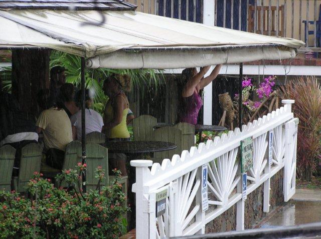
It's been raining pretty steadily for the past hour or so. I'm screwing down
my wood shutters on Crabby's as the wind kicks up from time to time. The
attached photo(taken a short time ago) shows Coral Bay people scurrying
around for storm prep. Well, it will keep the rain out of their drinks. They
make me feel like the pig that built the brick house, I'd rather be partying
with them but I've got too many things to do. Hope everyone stays
safe-Crabby
Your message is ready to be sent with the following file or link
attachments:
004 (2)
Note: To protect against computer viruses, e-mail programs may prevent
sending or receiving certain types of file attachments. Check your e-mail
security settings to determine how attachments are handled.
Attachment:
004 (2).jpg
Description: JPEG image
|
|
- Irene
|
- By "Val Donaghue" <lowcalval at earthlink.net>
- Date: Sun, 21 Aug 2011 12:20:59 -0400
|
|
Hey all
Irene has apparently been upgraded to a
hurricane..Right now Cruz Bay is very dark and some rain is coming in...I've got
yo turn my Suzuki around in the driveway so rain doesn't pool TOO much in the
floors...according to NHC we were not to be impacted until tonight through
Monday am...but MoM Nature has her own set of rules.......Boats in Cruz Bay
harbor did not move or many did not secure extra lines, WE DID, so hope
all fairs well. The cats are getting a little fidgity, but are liking the
breeze...Satellite radio is having some issues...But for now all is okay
lowcalval
|
|
|
- "Last boat in before the rain: Hurricane Hole"
|
- By crabbys at earthlink.net
- Date: Sun, 21 Aug 2011 12:04:20 -0400 (EDT)
|
Some of the boaters in Coral Harbor moved their vessels into Hurricane Hole for
safety.  This photo is of a boat under sail getting into the hole just as one
of the large rain bands from TS Irene moves in from the east (looks like the
horizon, but it isn't).   Many vessel either elected to remain in Coral Harbor,
didn't have time to move out, or the owners may be off island.  It is getting
darker and very overcast, and the wind is starting to whisper.  Here it comes;
another "turn on the fire hose" round of rain.  Very heavy, but little wind at
this point. I will keep posting as warranted.
Attachment:
IMG_0137.JPG
Description: JPEG image
|
|
- heavy rain, lightning and thunder
|
- By crabbys at earthlink.net
- Date: Sun, 21 Aug 2011 02:01:11 -0400 (GMT-04:00)
|
Just after 1:15 a.m. AST, someone turned on the firehose!  There are continuing
bands of "open faucet" rain coming down.  If this is any indication of the next
day and a half, we are in for a very wet Irene.  The bad part is, we went
directly to a storm warning with the storm nearly here, and it appears folks
may be doing some of those final preps in this off-and-on heavy rain -- never a
fun or safe thing.  Storm warning came at 7 p.m. last night, and that was just
at dark.  And now the thunder and lightning is gearing up. Be safe!!!  Hope the
power stays on.
|
|
- Tropical Storm Warning up for TS Irene
|
- By crabbys at earthlink.net
- Date: Sat, 20 Aug 2011 19:27:54 -0400 (GMT-04:00)
|
Tropical Storm Warning for US Virgin Islands
___________________________________________________
Statement as of 7:00 PM AST on August 20, 2011
Share This


...Tropical storm forms east of the Leeward Islands...tropical storm
warnings issued...


summary of 700 PM AST...2300 UTC...information
----------------------------------------------
location...14.9n 58.5w
about 190 mi...305 km E of Dominica
about 215 mi...345 km ESE of Guadeloupe
maximum sustained winds...50 mph...85 km/h
present movement...W or 280 degrees at 22 mph...35 km/h
minimum central pressure...1006 mb...29.71 inches


watches and warnings
--------------------
changes in watches and warnings with this advisory...


a Tropical Storm Warning has been issued for Puerto Rico and the
U.S. Virgin Islands...Vieques and Culebra.


The government of Curacao has issued a Tropical Storm Warning for
Saba...St. Eustatius...and St. Maartin.


The meteorological service of Barbados has issued a Tropical Storm
Warning for Dominica.


The government of Antigua has issued a Tropical Storm Warning for
Barbuda...St. Kitts...Nevis...Antigua...Montserrat...
Anguilla...and the British Virgin Islands.


Summary of watches and warnings in effect...


a Tropical Storm Warning is in effect for...
* Puerto Rico...U.S. Virgin Islands...Vieques and Culebra
* Saba...St. Eustatius...and St. Maartin
* Dominica
* Barbuda...St. Kitts...Nevis...Antigua...Anguilla...Montserrat
* British Virgin Islands


tropical storm conditions could occur elsewhere in the northern
Leeward Islands tonight and early Sunday.


Hurricane conditions could occur in the Dominican Republic late on
Monday.


A Tropical Storm Warning means that tropical storm conditions are
expected somewhere within the warning area within 36 hours.


For storm information specific to your area in the United
States...including possible inland watches and warnings...please
monitor products issued by your local National Weather Service
forecast office. For storm information specific to your area outside
the United States...please monitor products issued by your National
meteorological service.


Discussion and 48-hour outlook
------------------------------
at 700 PM AST...2300 UTC...the center of Tropical Storm Irene was
located near latitude 14.9 north...longitude 58.5 west.  Irene is
moving toward the west near 22 mph...35 km/h...and a motion toward
west-northwest at a slower rate of speed is expected during the
next 48 hours.  On the forecast track...Irene will pass through the
Leeward Islands early Sunday...and move into the northeastern
Caribbean Sea on Sunday.  Irene could approach the Dominican
Republic late Monday.


Data from an Air Force Reserve hurricane hunter aircraft indicate
that maximum sustained winds are near 50 mph...85 km/h...with
higher gusts.  Some strengthening is forecast during the next 48
hours and Irene could become a hurricane on Monday.


Tropical storm force winds extend outward up to 120 miles...195 km
...Mainly to the north and east of the center.


The latest minimum central pressure reported by an Air Force Reserve
hurricane hunter aircraft was 1006 mb...29.71 inches.


Hazards affecting land
----------------------
wind...tropical storm conditions are expected in the Leeward Islands
tonight into early Sunday.  Tropical storm conditions are expected
to begin Sunday afternoon in the Virgin Islands and Puerto Rico.
Hurricane conditions are possible over the Dominican Republic
by late Monday with tropical storm conditions possible by Monday
afternoon.


Rainfall...Irene is expected to produce total rainfall accumulations
of 4 to 7 inches in the Leeward Islands...Puerto Rico and the
Virgin Islands...with isolated maximum amounts of up to 10 inches.
These rains could cause life-threatening flash floods and mud
slides in areas of steep terrain.

Storm surge...a storm surge will raise water levels by as much as 1
to 3 feet above normal tide levels along the immediate coast in the
warning area.  Near the coast...the surge will be accompanied by
large and dangerous waves.


Next advisory
-------------
next complete advisory...1100 PM AST.


$$
Forecaster Blake/Brennan
|
|
- Tropical Wave Expected to Bring Heavy Rains, Gusty Winds Beginning by Sunday Night
|
- By crabbys at earthlink.net
- Date: Sat, 20 Aug 2011 14:23:34 -0400 (EDT)
|
Just forwarding this from local emergency management re: tropical wave moving
through over the next few days.

________________________________________________________________________________

Tropical Wave Expected to Bring Heavy Rains, Gusty Winds Beginning by Sunday
Night

Alert / Warning
Meteorological - SPECIAL WEATHER STATEMENT

...This is an ACTUAL SPECIAL WEATHER STATEMENT ALERT...


Issued By:  VITEMA
Affected Jurisdictions:  Virgin Islands

Headline:  Tropical Wave Expected to Bring Heavy Rains, Gusty Winds Beginning
by Sunday Night

VITEMA is continuing to closely monitor a large tropical wave located about 400
miles east of the Lesser Antilles and moving westward to west-northwestward at
about 20 miles per hour.

According to the National Weather Service’s National Hurricane Center most
recent update, shower activity associated with this system continues to show
signs of organization, however, there is no evidence of a surface circulation
at this time. Slow development of this system is likely, and a tropical
depression could form over the next couple of days. This system has a high
chance, 80 percent, of becoming a tropical cyclone during the next 48 hours. An
Air Force reserve Hurricane Hunter aircraft is scheduled to investigate this
system later this afternoon, if necessary.

The National Weather Service has forecasted the system would bring
intermittent, localized heavy rains and gusty winds to the Virgin Islands,
particularly St. Croix, on Sunday afternoon into Monday.

VITEMA is urging the public to be vigilant and to monitor the progress of this
system as it moves across our region. Stay tuned to local radio, TV, NOAA
weather radio and VI Alert for updated information, watches and warnings. For
preparedness information visit www.VITEMA.gov ("http://www.vitema.gov/";) .

Audio Recording URL:
http://www.vialert.gov/Public/DownloadAudio.aspx?parentid=3264008&type=3
|
|
- Eye to the EAST
|
- By "Val Donaghue" <lowcalval at earthlink.net>
- Date: Sat, 20 Aug 2011 10:55:47 -0400
|
|
Good day all !
We've had typical summer weather here on STJ
lately...warm temps, warm water, occaisional showers... It's amazing
that on an Island this small, how much the weather can vary...by even a few
miles.. It could be raining buckets in Gifft Hill and be completely dry in
Cruz Bay, and Coral Bay... all at the same time
! Likewise, the streamer clouds have their own particular
paths, which determine what beaches will have sun...
It did feel a little
warmer than usual at Bootcamp class this a.m. a little more moaning
and groaning and more water drinking and red faces, and little breeze...but we
did it ! ( Last Saturday we did it in the big rain and thunder and
lightning...yikes) There was also a splash and dash out at Maho Bay this
a.m. Wow is St. John an active Isle!
Okay ...onto what we are looking
at...Invest 97L has become more organized and NHC has it as 80% chance of
developing...It seems that what we can expect HERE is some heavy rain
showers and some wind, but there is still uncertainty as to it's path
and strength...SOOOO we could get : nothing, a little
squally weather , lots of squally weather...Invests 98 and 99 seem to have
fizzled for now...
Have a great Saturday !
lowcalval
|
|
|
- Someone turned on the wind machine
|
- By crabbys at earthlink.net
- Date: Tue, 2 Aug 2011 20:06:04 -0400 (GMT-04:00)
|
Around 6:15 this evening, the wind started to really pick up out here in Coral
Bay.  We are getting gusts up near 40 knots, and we are nowhere near the center
of this storm.  Must have some pretty strong outer bands.  We have had some
heavy rain bands come through, but most of the day has been pretty dry.
|
|
- Storm damage
|
- By "crabbyswatersports" <crabbyswatersports at earthlink.net>
- Date: Tue, 2 Aug 2011 11:29:39 -0400
|
|
It's 11:30 AM and the sun is out here in Coral Bay. Now it will probably
rain again in another hour or so because that seems to be the pattern today.
Gusty winds occasionally but I'm guessing less than 30 knots and maybe the
sustained are around 15 knots. My flag pole with the large American flag
out in front of Crabby's is tilting at a 45 degree angle and it looks like
the image from the world trade center. Mostly it was due to years of rust on
the bottom holding bracket and it picked last night to give way and not so
much from the strength of Emily. I've actually had two families come in this
morning and rent snorkel gear but they just got in last night and they are
going to the beach today no matter what. They may have fun in the surf but
no tan today. Well, I guess the storm still has a few hours to make it's
closest approach but if it stays like it is now everything and everyone here
will be fine. I hope this is the last storm of the season, Hey, no harm
hoping-Crabby
|
|
- Tues am
|
- By "Val Donaghue" <lowcalval at earthlink.net>
- Date: Tue, 2 Aug 2011 06:32:23 -0400
|
|
Good morning all,
We had some pretty heavy rain showers ...off and on
starting around 3 am. None right now . We are under a Tropical Storm Watch
and should expect some more consistent rain and wind later this afternoon and
evening. The system will pass south of the Virgin Islands...Emily appears to be
somewhat less comsolidated this am...is still following along her predicted
course...so this is probably a 'practice run' for us here on STJ.
On another note...there are several waves coming
from the East and the Monsoon troff has shifted somewhat to the North...Stay
Tuned !
lowcalval
|
|
|
- what is up ?
|
- By "Val Donaghue" <lowcalval at earthlink.net>
- Date: Mon, 1 Aug 2011 16:57:09 -0400
|
|
Hey all,
Not much information going on down here...not a
good sign..a TS or not a TS...NHC...budget cuts ? Folks are somewhat preparing ,
but not taking things seriously due to the info we are getting/or the
lack there-of..
At any rate..had a swim at Gibney beach...smooth,
warm, mmmmm. A bit breezy at the house, but nice, the cats are not
melting as much... Skipper is sleeping in the 'mail' basket and looks
quite comfy.. maybe they will have a good can of tuna for
dinner..meow : ) Time to 'clean' the
inflatable pool...!
lowcalval
|
|
|
- td #5 or not
|
- By "Val Donaghue" <lowcalval at earthlink.net>
- Date: Sun, 31 Jul 2011 14:24:05 -0400
|
|
Hey allbut ,
I'm a little concerned that NOAA/NHC hasn't given
much more info or an update regarding status. We are all assuming that a
TD #5 has formed or perhaps a Tropical Storm has formed . Radar looks to be
showing edges of the storm coming close to the lower Islands all ready...What
gives ?
So far..today has been an absolutely gorgeous day
here on STJ. Got to hang some laundry out on the line and...it DRIED !.
Got to go for a swim and sun...towel brigade is in place and gutters
cleared..cat food FULLY stocked...According to Crown Weather, we will not be
impacted..if we are...until Wed...but start to think about what you need for 3-4
days if the 'electricky' is out...
: ) lowcalval
|
|
|
- Sat on my a** day
|
- By "Val Donaghue" <lowcalval at earthlink.net>
- Date: Sat, 30 Jul 2011 19:36:41 -0400
|
|
Hey all,
Well, no...I didn't sit on my butt all day...I
taught my bootcamp class, walked my friends dog up the hills of Cruz Bay, washed
towels in anticipation on the storm....why wash 'storm towels'..just
because...went to Gibney Beach...lovely today..all right ...the cats are
chashing a moth or other flying thing around the kitchen and making a BIG
production....gottta go !
lowcalval
|
|
|
- fair weather Friday
|
- By "Val Donaghue" <lowcalval at earthlink.net>
- Date: Fri, 29 Jul 2011 15:23:49 -0400
|
|
Happy Friday all
What a weird weather week here in Cruz
Bay...Thunder rumbles, wind gusts, down pours at night and during the
day...bright sunshine for about an hour then a down pour..and then again...every
time I start to pursue and outdoor activity, the rains come and then boom...sun
...It's funny because at the gym at Gifft Hill School you can see the weather
coming across the hills and then the down pours begin, but do not always make it
to Coral Bay or all of Cruz Bay.
Today was an exception in town...the sun came out
and stayed out and I was able to get some outdoor chores done. Cleaning the
'inflatable' pool, propagating some plants and moving others around...I'm so
ready to power wash the deck, driveway, and other concrete surfaces. Just have
to borrow a power washer : )
The cats have been melting on the floor and staying
close to the fans...and generating LOTS of cat fur, but, well, what's a cat to
do ?
Okay now, keep your eyes on the storm system out
East along the Monsoon troff...(I don't recall the Atlantic having a Monsoon
troff in the past , just the Pacific) but just be aware that it is out
there. Let's hope for fair weather this weekend...oh...and next week
. )
lowcalval
|
|
|
- stormy Saturday
|
- By "Val Donaghue" <lowcalval at earthlink.net>
- Date: Sat, 23 Jul 2011 16:45:55 -0400
|
|
Hey all....
Long time no words from me.. Today here on STJ has
been a weird weather day...Thunder and heavy rain in Cruz Bay in the early
a.m... things cleared out enough for Bootcamp class at 9:00 am with just a very
welcome sprinkle at the end. The sun came in and out and there were some
bigger rains, but we still managed a brief dip in the Intex pool and a quick BBQ
hotdog on the grill. Then again some rain... which has allowed my
husband to begin to create a sub-whoofer system for his man's world and for me
to continuue to read a book. Ahhhh...the Radar looks kind of ominous for the
evening. It's quite dark here right now. I think it's a good night for
making Chili in the crock pot and checking out the new 'sound system' in Man's
World.: )
Stay high and dry !
lowcalval
|
|
|
- More and more rain, lobsters and screen repair
|
- By crabbys at earthlink.net
- Date: Sun, 3 Jul 2011 18:28:35 -0400 (GMT-04:00)
|
Yet another downpour here in Coral Bay.  We have gotten just under two inches
of rain so far today -- on top of close to an inch the day before. And all this
is falling on pretty wet ground.  It seems as if the rain just keeps popping up
out of nowhere on the radar.  Hope this finally moves out.

Our beach lobster boil did take place -- mostly during one of the drier spots
of this whole mess.  About four dozen people showed up to eat Maine lobsters,
steamers, clams and oysters on the half shell, and various other goodies.
There was also a gas-powered drink blender.  A good time was had by all in
spite of the overcast day.

We haven't had a chance to fix the screens yet from the "big blow" several days
ago, but will have to get on it before the next batch of mosquitoes arrives.
|
|
- The wind blew, the kayaks flew.....
|
- By crabbys at earthlink.net
- Date: Fri, 1 Jul 2011 16:37:51 -0400 (GMT-04:00)
|
Holy cow!  A passing tropical wave really kicked us in the butt a short time
ago.   Heavy potted plans were overturned and large screens blew out up here
above Coral Harbor.  There are reports of winds measuring over 50 mph on
several spots across the island and some trees down.  Several of the kayaks
down at our watersports business blew of the rack into the parking lot.  We
knew there was a chance of a wave coming, but nothing like this.  The wind and
rain has been stronger up here than we have seen in some tropical storms!
|
|
- Rain from now til ...
|
- By crabbys at earthlink.net
- Date: Sun, 5 Jun 2011 19:08:51 -0400 (GMT-04:00)
|
The rain moved in this afternoon and has been falling fairly steadily ever
since.  We are totally socked in with low-hanging clouds, and the temperature
has fallen to around 70 degrees.  The wind has begun to pick up a bit from the
southwest -- no surprise since that is where this blob of weather is moving
from.  The forecast has very high changes of rain right through Tuesday, then
things should improve.  Everything is starting to feel damp and wet, and the
frogs are singing up a storm!!
|
|
