
|
- - - 2010 Hurricane Season - - -
|
- Fwd: FLOODING IN GRENADA
|
- By Gert van Dijken <gert at vandijken.com>
- Date: Tue, 12 Apr 2011 07:20:47 -0700
|
---------- Forwarded message ---------- From: Glenda Juerakhan <glenda_juerakhan at yahoo.com>
Date: Tue, Apr 12, 2011 at 7:02 AM Subject: FLOODING IN GRENADA
This is the wettest dry season I have ever seen!.
THIS NEWS IS BY WEEFM.
Posted By Mikey Hutchinson On Tuesday 12 April, 2011, 8:09 am
Grenada has experienced severe flooding this morning.
We have received numerous reports of flooded houses, landslides, road blockages, sunken boats and destroyed houses.
In Gouyave, one house was destroyed by the violent river, which overflowed its banks.
Road access from Waltham, St. Mark to Victoria has been blocked. Also, the Balthazar bridge has been flooded as well. In Clozier, St. John, access to Gouyave has been cut off due to a land slide.
We have also received reports of destroyed houses, washed away cars and flooded houses from neighbouring St. Vincent.
We will update you further on new developments.
Best wishes
Glenda Caron Juerakhan
--
Gert van Dijken
Caribbean Hurricane Network
http://stormcarib.com
|
|
- Rain Rain Rain.
|
- By Chris Bolt <gommier at gmail.com>
- Date: Tue, 12 Apr 2011 09:20:19 -0400
|
Hi all,
Not the day for being in the lesser Antilles! There is a huge area of
moist air pushing up from South America. This is most unusual. There
are still week N.Easterlies, and these seem to be clashing with the
Southerly moist air flow causing a mixture of showers and 100% overcast.
At the moment I can't see this changing for a few hours, at least
(hopefully I am wrong. As I write this we are having very heavy rain.
Anyway, we won't need to water the plants for a few days!
Looking around, Barbados has had rain for about 12 hours, St Lucia 14
hours.
Have a nice day, if you can.

Hogan of Grenada
|
|
- Sunday 6:40 AM
|
- By Chris Bolt <gommier at gmail.com>
- Date: Sun, 03 Apr 2011 06:50:32 -0400
|
A[art from a very few radar reflections, a couple off Grenada south
coast and a few near Barbados, the Eastern Caribbean looks like a
typical Dry Season day. Strong Easterly winds and small clumps of clouds
rushing across the Atlantic in the Trade Winds, a few of them could
bring short showers, as they bubble up.
Now time for some early morning gardening.

Hogan of Grenada
|
|
- Sorry to have not done any posts for some time.
|
- By Chris Bolt <gommier at gmail.com>
- Date: Fri, 01 Apr 2011 07:48:36 -0400
|
Hi to all of you interested in the weather in Grenada. I am sorry, but
I haven't done a post since 16th January!
We had no sooner got back from the UK, having been there to celebrate
Christmas with my mother, when we had a phone call saying she had been
taken into hospital. So we rushed back to see her. She was in hospital
for two months and finally died on 4th March. We have come back to
Grenada for a short break before going back to sort out mums things and
do paperwork. So we will be away again for a couple of months. I will
try to keep an eye on what is happening, weather-wise, in Grenada and do
posts, when I can.
As for the weather now. The last few days have made it look like the dry
season has really arrived - AT LAST. I hear you have had plenty of rain
since we left.
Today is somewhat over cast, mostly caused by high cloud sweeping off of
South America. There are very few showers showing on the radar (07:42),
yet I did see what looks like a small shower a couple of miles south of
us a short while ago.
Look after Grenada for us until we return.

Hogan of Grenada
|
|
- Still no Martinique radar!
|
- By Chris Bolt <gommier at gmail.com>
- Date: Sun, 16 Jan 2011 06:54:26 -0400
|
Sunday Morning,
For many days now Martinique radar has not been displayed. Therefore it
is difficult to see rain showers in the vicinity. The Atlantic satellite
images show a steady flow of clumps of clouds moving across the Atlantic
Ocean. So it looks as if we will get sunshine with the occasional
shower. Reasonably high winds appear to be with us for a couple more
days, at the least.
Hogan of Grenada
|
|
- Unable to give much of a forecast today!
|
- By Chris Bolt <gommier at gmail.com>
- Date: Fri, 14 Jan 2011 10:42:06 -0400
|
Good morning Grenada,
The radar from Martinique seems to have been out of action since
yesterday afternoon. With out that it is difficult to see how much rain
there is in the area. Still it looked reasonably OK so we got
paintbrushes out to paint a wall. Instantly the rain came! So now what
we want to paint is wet, even if it does stop raining.
Going by the satellite images it looks like numerous areas of cloud
drifting in our direction. Any of these could potentially give rain
showers. The wind has dropped off a bit since yesterday.
Yesterday I got the forecast correct, is this a first? Maybe I should
quit while I am ahead?
Have a good day.

Hogan of Grenada
|
|
- Wet & roof rattlingly windy night!
|
- By Chris Bolt <gommier at gmail.com>
- Date: Thu, 13 Jan 2011 07:13:04 -0400
|
Morning Grenada,
Stepped out of bed into a very wet floor this morning. The rain has
whipped the rain across the veranda and under the door. The roof was
sounding like it did during Emily, except I think there was only one
elephant running across the roof instead of the whole herd!
The radar shows a few showers still in the vicinity and the satellite
images show the clump of very wet weather is still passing through
although It does look as if it should improve in the next few hours.
Windguru is predicting the high winds to remain for the rest of today.
Have a good day.

Hogan of Grenada
|
|
- Frequent showers this morning.
|
- By Chris Bolt <gommier at gmail.com>
- Date: Mon, 10 Jan 2011 07:25:05 -0400
|
Good morning Grenada,

We are back on the island after spending Christmas in the UK.
We have woken up to a few brief heavy showers this morning. As far as I
can see they appear to be developing where some mid to high moist air
sweeping out from the Caribbean area is meeting Easterly winds coming in
off the Atlantic. The forecast I have seen is for 'the occasional
possibly heavy shower' in this region. While the higher cloud is
sweeping in from the West we will see little sun. Hopefully this will
break soon.
It is so nice to be back. At least the plants are still green.

Hogan of Grenada
|
|
- The 95L blob
|
- By Chris Bolt <gommier at gmail.com>
- Date: Tue, 21 Dec 2010 17:35:34 +0000
|
Hi all,
It looks like the 'blob' is passing near Barbados now, 16:57. It
appears that the main rain band will pass north of Grenada, but could
bring some showers.
Hogan of Grenada
|
|
- Upside down weather. 95L is out there!!!
|
- By Chris Bolt <gommier at gmail.com>
- Date: Mon, 20 Dec 2010 23:01:39 +0000
|
In the UK more chaos with airport delays, Rail and road disruptions all
due to snow and very cold weather.
Nearer to Grenada, there is a weather system about 200 miles ESE of
Barbados that has a 30% chance of developing into a tropical
depression! Hey this is December. This system is likely to bring heavy
rain and windy weather to parts of the Lesser Antilles
Tuesday/Wednesday, the few predictions so far have it going between
Grenada and St Vincent. This is per the National Hurricane Centre - no
kidding!
Here in Ely in the UK, despite hearing about all the snow over the last
few days, we haven't had one snowflake. The snow that is still on the
ground was from almost a week ago. The river Great Ouse that passes
through Ely is beginning to freeze over in places. The freeze continues.
Hogan of Grenada
|
|
- 09:00 GMT - 05:01 Grenada time
|
- By Chris Bolt <gommier at gmail.com>
- Date: Sat, 18 Dec 2010 09:25:39 +0000
|
Good Morning Grenada, from freezing UK!
We are still in the UK. It is cold and today there is heavy snow due to
pass through both Gatwick and Heathrow in the next few hours. British
Airways has cancelled ALL flights out of Heathrow between 10:00 through
17:00!! The BBC has just shown a reporter at Gatwick where the snow has
just started. The reason I am sending this is because I know there is a
BA flight to Grenada today (BA2153). It is due to leave at 11:55. The
BA departures website (see BA.com) says the flight is still due to
operate. For anyone expecting passengers on this flight today I would
suggest you keep an eye on the above website!
Looking at Grenada, I see many showers north of Grenada between St
Vincent and Barbados, they appear to be moving slowly southwards.
We are back there soon, can't wait!

Hogan of Grenada
|
|
- Weather
|
- By Sunshine Redhead <jenzania at hotmail.com>
- Date: Fri, 17 Dec 2010 18:54:45 +0100
|
Hi,
Now yesterday was kinda strange cause, the sun came out hot, hot and then about in the afternoon time so the weather just changed and we experienced some heavy, heavy down pours (it caused flooding in our town,St. George's) and out of now where was a big gurst of thunder. Well today is partially sunny with few issoclated showers. The sun is trying to shine its way through. Good Luck Mr. Sun!!!
Ms.Jennelle Redhead
Customer Service Representative
Guyana and Trinidad Mutual Group of Insurances Companies Limited
Tel: (473)-440-2351 or (473)-449-5029 or (473)-440-2839
|
|
|
- Heavy Showers, cool breeze.
|
- By "Jacquie Dowden" <jacquiedowden at hotmail.com>
- Date: Fri, 10 Dec 2010 00:42:35 -0400
|
Well Hogan, not that I would enjoy the cold but I am slightly jealous of
the fact that you are in England. I am counting the days to early February
when one of my daughters arrives with her family.
Today was, as usual, hot but we did have a couple of light showers during
the day at Grand Anse. Now at 12.27 am it has just stopped raining.....
we’ve had three very heavy showers this evening at Mt. Moritz with a nice cool,
can I actually pull a sheet over me, breeze. Being in England at the
moment Hogan would laugh at my Grenadian neighbour who confessed the other
morning to wearing socks some nights!!!!
Everything here is building up to Christmas, holiday spirit appears to have
overtaken most people and a relaxed mood is rife. Ham seems to be
upsetting a lot of people this year..... not in the tummy ache sense but because
the hams are all very large few can afford a whole one. Shops are cutting
them in half to accommodate customers and I suppose half a ham is better than
none.
Hoping it is dry in the morning to enable me to get to work without getting
soaked, oh I am so looking forward to the time off at Christmas.
Jacquie
xx
|
|
|
- Freezing cold, clear skies, need to wrap up warm!
|
- By Chris Bolt <gommier at gmail.com>
- Date: Thu, 09 Dec 2010 17:55:34 +0000
|
Hi Grenada,
Well, the weather is exactly per the subject line - that is in the UK
where we are now. The forecast is for it to get a bit milder for a few
days then the UK is to go into another freeze! Not that all you in
Grenada will have those worries!!!
Looking at the weather for Grenada, it looks like sunshine with a few
showers! I see a small band of rain that may pass through later today.
Wish we were still there. brrrrrrrr. I will do my best to send updates,
but I won't have the first hand visual update for you for a couple of
weeks. Back soon though, enjoy the warmth!
I am happy to receive emails giving first-hand conditions.

Hogan of Grenada
|
|
- Maybe a brighter day today?
|
- By Chris Bolt <gommier at gmail.com>
- Date: Sun, 05 Dec 2010 07:01:47 -0400
|
The slow moving weather system that has blanketed us for the last few
days has (almost) moved away. The drier bit that was following has been
squeezed, but hopefully should give us some brighter spells today.
Before the faster moving system moves in from the East.
Looking out, it is a much nicer morning than recently, plenty of blue
sky and few low clouds.
Have a nice Sunday.

Hogan of Grenada
|
|
- This weather system is taking its time!
|
- By Chris Bolt <gommier at gmail.com>
- Date: Sat, 04 Dec 2010 18:52:20 -0400
|
Although we have had no rain (in Westerhall) today, we are still being
affected by this slow moving area of weather. The majority of it is to
our west, there is a band of drier air trying to come in behind it (from
the East), but still we have some rain between us and Tobago, which may
give us some rain over night.
I have just checked the Eastern Caribbean and all the islands are
reporting 'mostly cloudy, with Tobago saying showers in the vicinity.
They have had rain a good bit of the afternoon.
A little bit further out in the Atlantic is an area of fairly heavy
convection which seems to be squeezing the drier air out.
Maybe, with a bit of luck we could have a brighter day tomorrow? perhaps
with showers.
Hogan of Grenada
|
|
- Dark skies to the South of us.
|
- By Chris Bolt <gommier at gmail.com>
- Date: Fri, 03 Dec 2010 06:49:02 -0400
|
Good morning Grenada,
Looking out there are dark skies to the East, South East and South. The
radar is showing rain in the same place. This is the same rain area that
I mentioned last night. It has crept towards us, but the question is
will it ever arrive. It is part of a small bulge trying to push North.
I think I can still see the horizon to the East through South so it
doesn't appear t be dropping much in the way of rain. Will it get here
or fizzle out, that is the question?
Mostly overcast with an Easterly wind.

Hogan of Grenada
|
|
- Rain showers heading our way?
|
- By Chris Bolt <gommier at gmail.com>
- Date: Thu, 02 Dec 2010 17:40:56 -0400
|
Good evening.

Just had a lovely day, got plenty done in  the garden.
I have just looked on the radar and satellite images and there is a
chance of us having some rain this evening/night. The rain is currently
halfway between Tobago and us, it doesn't appear to be heavy,, at the
moment it seems to be moving in our direction. Quite often this rain
that pushes up from the south does not reach us, let's see!
Hogan of Grenada
|
|
- Very few showers anywhere in Eastern Caribbean.
|
- By Chris Bolt <gommier at gmail.com>
- Date: Wed, 01 Dec 2010 10:42:43 -0400
|
Although there are no showers (to speak of) in our area, I have just
experienced fine rain falling from a blue sky! The Water vapour
satellite loop is showing very dry air pushing down through the Eastern
Caribbean. But there is still moisture to the South of us. The ongoing
battle between wet and dry continues.
Yesterday turned out a very pleasant day - I was wrong again!

Hogan of Grenada
|
|
- Good Tuesday morning - plenty of rain yesterday!
|
- By Chris Bolt <gommier at gmail.com>
- Date: Tue, 30 Nov 2010 06:16:36 -0400
|
Sorry I did not do a post yesterday, I was somewhat busy. Now if I had
done it yesterday, I would have said that it looked as if we would have
had a pleasant day with an occasional shower, just shows you how wrong I
would have been!
Today my feeling is about the same, there are hardly any showers showing
on the radar, and the satellite images show that there is a band of
showers along the N. coast of South America, but they do not look like a
threat to us. We are in a N.Easterly wind stream. There are areas of
cloud that potentially could bring showers. So my best guess is that
today will have good spells of sun mixed with some spells of cloud, with
rain showers. The showers should be fast moving so not last too long.
Looking out, the sky is about 80% overcast. There are a few low clouds
moving past from NE and scraping the tops of the mountains. Above that
there is a higher and more widespread layer of clouds that are hardly
moving. It is this layer causing most of the cloud cover at present.
Now to redo the painting that got washed away yesterday!  Have a good day.

Hogan of Grenada
|
|
- Good Tuesday morning to you.of rain yesterday!
|
- By Chris Bolt <gommier at gmail.com>
- Date: Tue, 30 Nov 2010 06:12:53 -0400
|
Sorry I did not do a post yesterday, I was somewhat busy. Now if I had
done it yesterday, I would have said that it looked as if we would have
had a pleasant day with an occasional shower, just shows you how wrong I
would have been!
Today my feeling is about the same, there are hardly any showers showing
on the radar, and the satellite images show that there is a band of
showers along the N. coast of South America, but they do not look like a
threat to us. We are in a N.Easterly wind stream. There are areas of
cloud that potentially could bring showers. So my best guess is that
today will have good spells of sun mixed with some spells of cloud, with
rain showers. The showers should be fast moving so not last too long.
Looking out, the sky is about 80% overcast. There are a few low clouds
moving past from NE and scraping the tops of the mountains. Above that
there is a higher and more widespread layer of clouds that are hardly
moving. It is this layer causing most of the cloud cover at present.
Now to redo the painting that got washed away yesterday!  Have a good day.

Hogan of Grenada
|
|
- A very wet night.
|
- By Chris Bolt <gommier at gmail.com>
- Date: Sat, 27 Nov 2010 06:23:41 -0400
|
Good morning Grenada,
After a very wet day, we had a wet night, although the pool level has
not risen much since yesterday evening.. At least it was cool. The two
inlets below us are brown with run off.
Looking at the various sites, it appears the rain band has moved north
towards St Lucia & Martinique. There are showers to our west, but these
appear to be moving away. There are no showers, at the moment, to our
East, but the Satellite imagery shows we are still in a moist area, but
with little convection/showers. I am not sure how much Sun we will see
today, but hopefully more than yesterday.
A quick look outside - It is mostly overcast with medium/high clouds. A
few low clouds, scattered, with a rather darkish one directly over
Westerhall, but no rain. Out to the East I can see a break in the
clouds, just where the sun is about to rise. A glimmer of hope.
With the solar water down to lukewarm I hope we get some sunshine today.
Also we hope to do the gardening we were unable to do yesterday.
Hogan of Grenada
|
|
- If you want to see what is hitting Grenada -
|
- By Chris Bolt <gommier at gmail.com>
- Date: Fri, 26 Nov 2010 13:38:28 -0400
|
Attached is the screen dump of martinique Weather radar (thanks
Martinique) taken at 13:15 our time. From this, if you can find
Grenada, you can see that North of Grenada does not have (many) showers.
We just seem to be in the wrong place at the moment.
Grenada can just be seen under the green blob at the bottom of the lower
circle.
So much for the gardening I mentioned!

Hogan of Grenada


You have been sent 1 picture.

Fullscreen capture 26112010 132754.jpg

These pictures were sent with Picasa, from Google.
Try it out here: http://picasa.google.com/
Attachment:
Fullscreen capture 26112010 132754.jpg
Description: JPEG image
|
|
- Following on to my last post -
|
- By Chris Bolt <gommier at gmail.com>
- Date: Fri, 26 Nov 2010 11:41:01 -0400
|
Well I think the moist air is winning!

Hogan
|
|
- Clash between wet and dry!
|
- By Chris Bolt <gommier at gmail.com>
- Date: Fri, 26 Nov 2010 09:08:07 -0400
|
Good morning.
The SE Caribbean appears to be in the dividing line between Moist air to
the South and Drier air to the North. The Martinique Radar images show
many showers in our area (Mostly south of a line between St Vincent and
Barbados. So today is a case of seeing which wins, wet or dry, or a bit
of both!?
Sorry to be brief, but a bright spell means gardening!

Hogan
|
|
- Grim yesterday, maybe better today?
|
- By Chris Bolt <gommier at gmail.com>
- Date: Thu, 25 Nov 2010 07:37:59 -0400
|
Yesterday we had it overcast most of the day, we had very little rain,
yet I hear it was much wetter in the North of the island.
This morning looks a bit brighter than yesterday. We are still under
moist air, and still within range of a rather scattered ITCZ (Inter
Tropical Convergence Zone * - which is on its annual move South). There
are still signs of this ITCZ bulge and we are probably going to see its
affects for a couple more days.
The radar is showing just a few scattered showers in the area.
Looking out I see mostly cloud cover but with bits of blue sky popping
through. Slightly brighter to the West. There is a sign of a small
shower just East of here.
I think we will have a better day than yesterday. Now for some gardening.
* The ITCZ is an area where the NE trade winds, from the Northern
Hemisphere, meet the SW trade winds, from the Southern Hemisphere. At
this point a band of heavy rain/thunderstorms form. The ITCZ moves
further North in the Northern Summer, then South in the Northern Winter
(It follows the Sun). Many of the hurricanes spawn off the ITCZ. See
2010 hurricane paths from Unisys Weather -
http://weather.unisys.com/hurricane/atlantic/2010/index.html
|
|
- Don't really know what to say about today's weather.
|
- By Chris Bolt <gommier at gmail.com>
- Date: Wed, 24 Nov 2010 10:45:01 -0400
|
Good (late) morning,
I delayed doing a weather post today as it is really a puzzle what will
happen. I don't have to say that this mornings weather was rather damp
with overcast skies. There has been a glimmer of sunshine in the last hour.
The satellite and radar images give a rather unpredictable weather
pattern. The radar shows plenty of rain to the south and some showers
just to the North, possibly near Bathway? The satellite images show
heavy convection/showers about 30 miles south of Grenada. This appears
to all be part of the ITCZ bulge I mentioned. There is a high speed
Westerly jet stream whipping the tops of the convection off towards the
East (this is causing the high cloud layer). lower down we are having
really nice Trade winds from the ESE.
To me, it looks like an unsettled day, with the chance of rain at any
time. That is a good a guess as I can give.
A quick look outside tells me very little. The sky is hazy (high cloud
as I mentioned). The horizon is not clear. The sky does look darker
towards the South, towards the Showers.
All the best

Hogan of Grenada
|
|
- A bit of a bulge in the ITCZ
|
- By Chris Bolt <gommier at gmail.com>
- Date: Tue, 23 Nov 2010 16:02:54 -0400
|
Good afternoon.

We have had a lovely day, so far today. A nice breeze. A few drips of rain.
But looking at the radar and satellite images I see what looks like a
bulge in the ITCZ. It seems to be pushing some rain in our general
direction. Tobago is getting plenty of rain, Trinidad is having
thunder. There is a large blob of cloud about 80 miles to our East,
sort of between Tobago and Barbados. There appears to be a general
movement towards us. If this continues then we may have some rain over
night. The dry air has now been pushed much further north.
Hogan of Grenada
|
|
- We go into a Waning Moon
|
- By Chris Bolt <gommier at gmail.com>
- Date: Mon, 22 Nov 2010 07:41:35 -0400
|
The Moonrise/ Sunset was OK, but the sun disappeared behind clouds about
10 minutes before setting and the Moon was only just visible as it came
up. Still the few of us that were there had a bit of fun. Nice to do
something crazy occasionally!
With the Moon rising about 50 minutes later each evening we will be able
to see the dark evening skies coming back. As we approach the Christmas
period the very distinctive constellation of Orion will be getting
higher (the one that contains the three bright stars in a row), also the
Pleiadies, the bright cluster of stars, also known as the Seven Sisters
or, in Grenada, the Christmas Stars (I believe).
Today, there are no showers showing on the radar in this part of the
Caribbeean, although there scattered showers further north. The wedge of
drier air has now pushed down to below T&T. So it does look as if we
could have another dry day with just a chance of a shower. Well, that is
my guess anyway.
looking out there are the usual Grenada clouds around, scattered with
lots of sunshine. The horizon is a bit hazy, there is a nice breeze.
There are no showers visible. It looks a great day, so far.
Gardening day today.

Hope you all have a good week.

Hogan of Grenada.
|
|
- Dry air seems to have won out!
|
- By Chris Bolt <gommier at gmail.com>
- Date: Sun, 21 Nov 2010 15:11:08 -0400
|
What a change since yesterday. It is looking good, at the moment for
the 17:38 Moonrise/Sunset. We are planning to go to Ft Jeudy.
Hogan of Grenada
|
|
- Sorry I missed doing a post Yesterday.
|
- By Chris Bolt <gommier at gmail.com>
- Date: Sun, 21 Nov 2010 07:58:36 -0400
|
Good Sunday morning Grenada,
Yesterday, well what can one say? I woke up before 6am to fetch a
friend to help me finish building a wall. I didn't have time to look at
the computer so could not send a post. We worked through the morning
with only a brief stoppage for rain. We finished around midday when Mrs
Crumble and I were already late for a beach picnic, yes she did make an
apple crumble. I was meant to be getting the drinks! We were very late
arriving at the beach, with threatening dark skies. I still had not had
time to look at the weather web sites so did not have a clue what was
happening. Many of the people were asking me what we could expect. Well
we had no sooner spread the food out than the heavens opened. Most, but
not all, had managed to get a plate of food before disappearing to their
cars to eat it. With the car park flooding we decided to call it a day.
One of our group slid off the concrete track leaving the Aquarium beach,
no damage done, but took some time to get him back on the track. A
backup site where we had decided to try to complete the day (which had
cover) we found was being demolished. Still, Mrs Crumble and myself went
to a 12 year celebration for The Little Dipper in Woburn, where we had a
nice meal. The rain did not affect us. Apart from a dry spell in the
afternoon we had rain most of the evening and a lot of the night.
This morning we have woken to what looks like a better day. We have a
trade breeze. The sun is shining, a bit. The pool has risen by about 2
inches. The satellite images show an area of drier air trying, and
partially succeeding, to push down from the North. South of us are still
showers and heavy convection, also visible on the radar. So it looks
like a battle between the two areas for the day. Further out to the East
the drier air manages to push further down. So I think it will be a
better day than yesterday. It couldn't be much worse!
A last look out before sending this confirms what I have said above, the
skies to the South are darker and more overcast. A gentle easterly
breeze. The bays below are brown with rain wash off.
Hope you all have a good Sunday.  Sorry I did not do a post yesterday.

Hogan of Grenada
|
|
- No Breeze!
|
- By Chris Bolt <gommier at gmail.com>
- Date: Fri, 19 Nov 2010 07:37:56 -0400
|
07:00 The trees are not moving, the sea is calm, the four boats in
Calivigny Harbour are facing NW (there must be a slight breeze coming
off the land to turn them).
There is a small shower just off to our East, but it is slowly sliding
past us towards the South. There are other towering clouds scattered
around in most directions.
Looking at the various weather sites, we seem to be in an area of drier
air, but being squeezed out by a band of rain showers to the North of
Grenada and the ITCZ to the South. There is a bulge in the ICTZ about
halfway across the Atlantic, slowly coming in our direction. Which could
affect the weather in a few days time.
So for today it looks like sunshine and showers.
I hope the weather remains good for the weekend. A virtual full Moon
this Saturday, Official Full Moon Sunday. Sunday evening Sunsets at
17:38 and the Moon rises at 17:38. A good time to be on one of the
Southern Peninsulas (Ft Jeudy should be good). Hopefully see the sun set
and the sun rise at about the same time!
Have a good day.

Hogan of Grenada.
|
|
- Still rain in the area.
|
- By Chris Bolt <gommier at gmail.com>
- Date: Thu, 18 Nov 2010 06:59:38 -0400
|
About 06:30 -

It is very calm here in the South. The sea is like a mill pond.
The radar is showing showers around, Bathway has just had some rain. So
far it is dry in the South. There are numerous showers showing mostly
North of Grenada, most are up near Martinique. Barbados has had some
showers overnight. I am expecting to see passing showers at any time today.
A last look out before sending this, I see a shower well of to the
South. The boats in Calivigny Harbour are pointing in all directions
(lack of wind). All looks nice. At the moment.
Hogan of Grenada.
|
|
- The ripple is passing through.
|
- By Chris Bolt <gommier at gmail.com>
- Date: Wed, 17 Nov 2010 08:20:15 -0400
|
Over night we were woken up by the loudest and nearest thunder clap I
have heard this year. I will not repeat my words at the time. Apart from
a few distant flashes with corresponding rumbles about 15 seconds later,
that was it. We had some rain, not a huge amount.
This morning is sunny with the slightest of breezes barely moving the
trees. There are many bubbly clouds in most directions and we can see
showers from East through South to West.
The radar shows numerous showers throughout the Southern Caribbean. The
Satellite images show that we have entered the area (the ripple I
mentioned over the last two days) of unsettled weather. It has become
somewhat weaker over night, with less convection, as some drier air has
pushed in from the north, but it looks as if some showers could bubble
up, some heavy, any time during the day.
Something to watch out for this evening, At 18:35 (6.35pm) to 18:40
(6.40pm). The international Space Station (ISS) will pass almost
directly over Grenada. To see it, go out at the times mentioned (make
sure your timepiece is accurate), Face NW, at the earlier time, and look
for a bright dot coming up from that direction. It will travel almost
directly overhead at 18:38, then drop down to the SE by 18:40. It will
be over 200 miles above us, travelling at over 17000 miles per hour, at
this speed it travels round the Earth in about 90 minutes. It has 6
people on board. Hopefully the skies will be clear as this is the only
good evening pass for a while.
Have a good day, and evening.

Hogan of Grenada
|
|
- Eastern Caribbean generally dry(ish)! - correction
|
- By Chris Bolt <gommier at gmail.com>
- Date: Tue, 16 Nov 2010 07:59:39 -0400
|
Good morning Grenada.
Very little change today. Had some welcome rain during the night, good
for the garden.
Looking at the various radar/satellite and forecasts, it looks like
another pleasant day. The ripple, in the ICTZ, I mentioned yesterday has
moved slightly towards us, but is being held out by a wedge of drier air
coming from the north. It is still several hundred miles away and has
only limited rain/convection in it and that is mostly below 13N. If it
does continue then we may get some more chance of rain , possibly
thunder tomorrow or Thursday.
So today looks like a dry day with a chance of a shower. Currently, on
the radar, there are just scattered showers showing to the East of us
the temperature is , near Barbados. At 07:24 the temperature is
approaching 28C(82F) - that is an easy conversion to remember! There are
typical Caribbean fluffy clouds North, East and South, but clearer to
the West. There is a small shower about 8 miles south of Ft Jeudy, too
small to show on the radar. There is a very slight breeze from the NE
(the direction the clouds are moving from. The direction the Windguru
website predicts the wind to continue to come from all week.
So until tomorrow when we will see what if anything, the ripple/trough
is doing.
Hogan of Grenada
|
|
- Strange day yesterday!
|
- By "Wildingrenada (chris)" <chris at wildingrenada.com>
- Date: Mon, 15 Nov 2010 08:12:11 -0400
|
My post yesterday mentioned rain and disturbed weather. Well the strange
conditions lasted all day. The radar kept showing showers, many of them
visible scraping past the South coast. The sound of thunder just off
shore. reports from Bathway of welcome rain and thunder.It was
completely overcast all day, in Westerhall anyway. Yet how much rain
did we get here - NONE!
Today a much nicer looking day with fluffy clouds and hardly any rain
showing on the radar and yet, we have had two small showers already.
The radar doesn't give much hope for any more, but who can tell? A bit
further out in the Atlantic is a ripple in the ITCZ which could possibly
give more rain possibly tomorrow, but the Caribbean forecasters are
predicting it to be further south (T&T and Guyana).
As I prepare to send this at 08:10 there some shower looking clouds
billowing well off to the SSE to SE, these also show on the radar at
about 20-30miles away. Not heading in our direction. Nothing at the
moment to the east. A lovely day with a slight breeze.
I hope you all have a good week.

Hogan of Grenada.
|
|
- Looks like Carriacou is getting some rain.
|
- By Chris Bolt <gommier at gmail.com>
- Date: Sun, 14 Nov 2010 08:02:04 -0400
|
Sunday morning 08:00
I heard some thunder a short while ago, it sounded very distant. The
radar is showing many showers in the area. There seems to be a large
shower in the vicinity of Carriacou. The radar shows rain over the
South at the moment, but we have had nothing except a slight sprinkling.
The satellite images show us in a bit of disturbed weather, with many
showers popping up in a triangle bordered by Barbados-Tobago- Grenada
(Carriacou).
Hogan of Grenada
|
|
- 06:00 Saturday - Very little breeze
|
- By Chris Bolt <gommier at gmail.com>
- Date: Sat, 13 Nov 2010 06:17:35 -0400
|
I was woken up by the cat jumping on the bed and attacking my toes, then
knocking things off the bedside table!
We still seem to be in a mostly stable, dry area at the moment. Having
said that, the radar is showing a small clump of scattered showers about
60 miles to the East of Grenada, and slowly heading in our direction.
Whether these fizzle out I don't know. But looking out as the sun gets
ready to rise, I see some small, light showers only a few miles to our
East and approaching slowly. There is hardly a breeze as I write this.
Perhaps a bit more cloud than this time yesterday.
There is a developing weather system in the Western Caribbean (30%)
chance. This should not affect us in the Eastern Caribbean.
Hogan of Grenada
|
|
- Nice sound on the roof.
|
- By Chris Bolt <gommier at gmail.com>
- Date: Fri, 12 Nov 2010 06:18:58 -0400
|
Good morning,
I woke up to the sound of rain on the roof. After a few days of no rain,
and me losing some water in my tank, this is a lovely sound.
Unfortunately (for me) this rain hardly shows on the radar. There are a
few scattered blips South % West of us, but nothing showing to the East,
The Satellite images are showing more clouds than the previous few days.
Looking out from our veranda I see a few towering clouds one with some
rain dropping from it (at 06:15), so maybe we could have another shower
soon.
My guess is that we could have more showers than the previous days
(please note the word 'guess').
Hogan of Grenada
|
|
- More clouds than yesterday.
|
- By Chris Bolt <gommier at gmail.com>
- Date: Thu, 11 Nov 2010 07:37:15 -0400
|
Good morning,
We have started with another nice day. There appear to be more clouds
than yesterday. The breeze is still with us.
Looking at the satellite images we appear to be in a dryish area. The
radar is showing a few showers to the South and North of Grenada.
I am hoping for some rain as I accidentally left a hose running
overnight! I have lost some valuable rain water from my tank and would
like to get it topped up again!
Hogan of Grenada
|
|
- We appaer to be in a somewhat dry phase.
|
- By Chris Bolt <gommier at gmail.com>
- Date: Tue, 09 Nov 2010 06:23:35 -0400
|
Good morning Grenada.
No rain for a few days now. Looking at the weather radar there are
hardly any showers visible in the Southern Caribbean, as of 06:00 this
morning. The Satellite images show some heavy convection way out to the
ESE, more than 600 miles away. There is no indication that this will
develop.
About 400 miles to our West there is a system that the NHC are giving
about 10% chance of developing in the next 48 hours.
It appears that we could have another pleasant day.
An eyeball check around shows a SSE breeze, Few scattered low clouds,
the bottoms of these just scraping the tops of the Southern mountains
(about 2000 ft).
Hope you all have a nice day.

Hogan of Grenada.
|
|
- Re: Weather
|
- By Sunshine Redhead <jenzania at hotmail.com>
- Date: Mon, 8 Nov 2010 14:04:12 +0100
|
Hi Morning,
The weather being experienced today is sunny with clear blue skies, looks like we will have a great day!!!!!
Ms.Jennelle Redhead
Customer Service Representative
Guyana and Trinidad Mutual Group of Insurances Companies Limited
Tel: (473)-440-2351 or (473)-449-5029 or (473)-440-2839
|
|
|
- Tomas is passing Haiti as I send this.
|
- By "Wildingrenada (chris)" <chris at wildingrenada.com>
- Date: Fri, 05 Nov 2010 10:01:08 -0400
|
Good morning.
Just a brief note. The wind , and weather, is from the ESE. All seems
back to normal. The radar shows scattered showers all over the Eastern
Caribbean. Nothing else showing out in the Atlantic to give us any more
scares (as yet).
Haiti is getting Tomas, now back up to Cat 1 hurricane, just what they
didn't need. Reports of a couple of deaths from drowning in floods
(unconfirmed). I can't even imagine what high winds will do to the
tented cities.
All the best to all in Grenada.

Hogan of Grenada
|
|
- Haiti
|
- By "Jacquie Dowden" <jacquiedowden at hotmail.com>
- Date: Fri, 5 Nov 2010 05:45:15 -0400
|
|
Someone said 'Mother Nature does not see good or evil'
how true, but I'm sure we have all hoped that Haiti would have been spared this
storm. How much can a country withstand when Mother Nature is
throwing all she has at them. For the first time I have been reading how
people from other Islands have wished this storm on themselves in the desire to
see Haiti missed. We will find out in a day or two how bad it has been for
them and hope this storm will be the final one this season. The Islands
have had to wait till the last to realise that it 'ain't over till it's
over and our lovely Islands have paid the price again this year. My heart
goes out to all the Islands that have been ravaged by this storm..... there
really are no words.
Jacquie xx
|
|
|
- Haiti
|
- By storm tracker <grenadatracker at gmail.com>
- Date: Thu, 4 Nov 2010 21:17:09 -0400
|
|
Well I thought I had made my last post of the season earlier this week - but I have kept an eye on Tomas and to my utter dismay the storm seems to have really whipped up in the last three hours right on the doorstep of Haiti. Oh god I can't imagine trying to survive life in a tent, let alone dodge a cholera outbreak, weather hurricane force winds in a tent (or cowering in rubble) and then have to deal with the cholera aftermath that is sure to follow. How can the wealthy countries of the world have allowed so little progress to be made in nearly a year? Think about where Grenada was after Ivan and how far we had come a year after that!
What is happening to Haiti is heartbreaking.
|
|
- Rain for a good part of the night.
|
- By Chris Bolt <gommier at gmail.com>
- Date: Wed, 03 Nov 2010 07:10:43 -0400
|
It appears we have had a good bit of rain during the night. The pool
level has risen about an inch. Mrs Crumble tells me it rained most of
the night, yet I slept through it all! The outside temperature at 07:00
today is 23.8C, that is the coldest I have seen here for a while.
The radar shows we are on the west of a largish blob of rain, The rain
also fizzles out to the South. The Satellite images give the impression
it is moving East, in which case may be the rain could stop soon. But
our normal weather trends are for weather systems to move West, in which
case we could have rain for a while. Looking out it appears to be
getting brighter from the South.
Further out to the East, about 300 miles, is a 'trough' which is causing
heavy convection, this system is moving slowly west. We will have to
wait until tomorrow to see if that will bring further rain.
For those still interested in Tomas, it has been down graded over night
to a Tropical Depression (apparently mystifying the experts). It is
affecting a large area of the Central Southern Caribbean with heavy rain
and thunder. It is still expected to strengthen again and then to turn
North towards Haiti, possibly scraping the East of Jamaica. But as the
change in it has baffled the experts, I guess the predicted path will
also be a puzzle to them.
As I end this, the rain has almost stopped, for the time?

Have a good Wednesday.

Hogan of Grenada
|
|
- Trade wind appear to be back.
|
- By Chris Bolt <gommier at gmail.com>
- Date: Mon, 01 Nov 2010 17:13:22 -0400
|
Good evening Grenada,
It is so nice to have the trade winds back, but not so nice to have the
noisy kites back! I thought this was meant to be an Easter pastime??
Also, the height these kites fly at, could it be a danger to low flying
aircraft? An SVG pilot once told me he landed at Carriacou to find
twine round his propeller spindle, he glanced behind the plane to see if
there was still someone holding on!!! It took him about an hour to
untangle the kite line.
The current weather: A strong Easterly breeze, very hazy. There are no
showers showing on the radar.
Just to keep us on our toes, there is another 'trough' 48 hours East of
Barbados. There is no mention of this developing, yet. Although they
(NHC) do mention a slight sign of 'cyclonic turning'!
Tomas appeared to jump about 100 miles West earlier today. Apparently
the centre was well away from the convection, then it suddenly caught
up. If you are quick you will be able to see this on the satellite loop
: http://www.ssd.noaa.gov/goes/east/tatl/loop-avn.html
All the best

Hogan of Grenada
|
|
- Below the belt
|
- By storm tracker <grenadatracker at gmail.com>
- Date: Sun, 31 Oct 2010 21:24:26 -0400
|
|
Goodnight Hogan, Sally, Jacquie, and Chris....seems we're in the clear and maintain our status 'below the hurricane belt' and hopefully it will remain that way because the hurricane season is supposed to be over! I have little doubt that when the Alliance of Small Island States meet in Grenada this week to discuss climate change, Tomas will be on the tip of everyone's tongue's.
Everyone in Grenada who was here for Janet, Ivan or Emily can relate to how people are feeling in parts of St. Vincent, St. Lucia and Barbados today. Being underneath any kind of hurricane is a horrible experience and I'm glad it's over for them now. I'm sure there are a lot of very tired people getting a good hard (and mosquito bitten) night's sleep in our neighbouring islands so I for one will be going to bed tonight counting my blessings as I listen to the remnants of Tomas' wind howl in the window screens.
Until next we need to meet....TTFN
"Jen"
|
|
- The umbilical cord broke!
|
- By "Wildingrenada (chris)" <chris at wildingrenada.com>
- Date: Sun, 31 Oct 2010 18:38:46 -0400
|
I have delayed doing this post as I wanted to feel sure we were in the
clear from Tomas.
In the last post I mentioned the appearance of what I called an
umbilical cord connecting Tomas to the 'Tail'. Just after I sent the
post the string of rain, connecting the two, did start to break and very
rapidly the tail started to just disappear. At the same time Tomas
seemed to lose some of its structure. Satellite images are now showing
it somewhat broken, yet the NHC are still having it as a hurricane.
We, in Grenada came through this safely. My one hope is that, in
future, people still take hurricane and tropical storm warnings
seriously. We were very lucky this time. We were very close to this
storm, but just happened to be in the Southern side of it. The next one
may not be so kind to us. The experts may not always get it right, but
they do their best. We on Storm Carib are not experts, we just try to
pass on information that we pick up from the many sources. We try to
interpret them so they become more local. I really hope that everyone
looking at these posts have liked what we have said.
I would like to thank Sergio who sent me an email from the UK thanking
us for the posts. He has links to Grenada and has found our posts very
useful. Ta!
Hopefully we can go back to more mundane updates now and that this will
be the end of the season for us. And all of us should think of the
people in the other islands that didn't come of as lightly as us, this
time. Most of the people of Grenada know what many of the people of St
Vincent and St Lucia, and to a lesser extent Barbados, are going through
now. I wish them all well.
As for the weather here now: Much less high cloud, a good breeze from
the East (normal Trade Wind). And only the odd blip on the radar in this
area.
A peaceful night to you all.

Hogan of Grenada
|
|
- Whoops - No wind???
|
- By "Wildingrenada (chris)" <chris at wildingrenada.com>
- Date: Sun, 31 Oct 2010 11:36:24 -0400
|
Well as Storm Tracker says, it (or something) has arrived. The wind
started to pick up only 15 minutes after I did my last post. Over the
last few minutes as we had a big squall go through, we had some very
heavy roof rattling gusts. I turned out to be correct about the wind,
but my timing is somewhat out!! I hear you mumbling 'yes 24 hours'.
The radar is showing what looks like an umbilical cord stretching from
Tomas right through Grenada to 'The Tail'. It, the tail, is still well
off to our east though. This system gets more and more strange. See
radar image attached.
Tobago has been getting 12 hours of thunder and sometimes heavy rain.
And all of this is all still to our East. This tail has been left
behind, and is only linked now by this cord. Hopefully when the cord
breaks the 'tail' will become a still birth! We can do without son (or
daughter) of Tomas!!
Hogan of Grenada


You have been sent 1 picture.

Fullscreen capture 31102010 112323.jpg

These pictures were sent with Picasa, from Google.
Try it out here: http://picasa.google.com/
Attachment:
Fullscreen capture 31102010 112323.jpg
Description: JPEG image
|
|
- Weather has arrived
|
- By storm tracker <grenadatracker at gmail.com>
- Date: Sun, 31 Oct 2010 10:53:21 -0400
|
|
The weather we've been watching for all weekend has arrived - thankfully it's the back end of the storm. As Tomas strengthens, his tail is getting larger and more ominous as it approaches us so flooding may be a concern for us after a few hours of this rain. Trinidad has been under the tail for a couple of hours already, but local reporters haven't posted to tell us what's happening under those cold cloud tops. Presently, my backyard is obscured by rain and the temperature is predictably chilly as we get Tomas' outflow.
|
|
- A very Irish storm.....
|
- By "Sally Stalker" <stalker at spiceisle.com>
- Date: Sun, 31 Oct 2010 09:56:20 -0400
|
Sitting up here in the North of Grenada, storm shutters up (
and they will be until Tuesday, so help me..) the skies are overcast and the
seas are running high. The rain is intermittent and the wind is a mild.
In fact we are getting more weather than yesterday. Drove to Grenville early
this morning and the feeling up here is that we experienced our own little miracle.
News is that there were some fatalities in St Lucia and I am hoping this is not
so.
Tomas has been behaving erratically indeed and I wonder if
his tail is swishing around us still. Chris will keep us in the picture1
Hello Barbados, St Lucia, St Vincent hope you are beginning
to get it together again...good luck!
Sally
|
|
|
- What a night!
|
- By "Jacquie Dowden" <jacquiedowden at hotmail.com>
- Date: Sun, 31 Oct 2010 08:09:21 -0400
|
|
What a night, not for us but for St. Lucia and St.
Vincent. It appears St. Lucia is out of touch as far as phones are
concerned, hope we get news soon.
We had a calm night with no rain just cloud, thick
cloud. Now it is still a complete cloud cover and we should be getting the
rain Trinidad and Tobago has been experiencing some time today.
Jacquie x
|
|
|
- 06:00 Sunday - will we get the tail?
|
- By Chris Bolt <gommier at gmail.com>
- Date: Sun, 31 Oct 2010 06:30:05 -0400
|
06:00 Sunday Grenada:
Well the winds nor the rain have hit us - so far. Just before it
started to get light I could see lightning way off to SE to South, guess
that is from over Trinidad &Tobago, see below. They are reporting (on
Storm Carib) that the tail has reached them.
Tobago (only 80 miles SE of Grenada) received the sting in the tail, it
had thunder from 11pm last night all through the night (according to
Crown Point airport. Very little wind though.
Barbados (186 miles ENE of Grenada), Grantley Adams airport, has had
rain during every hour (except 1) over the last about 32 hours, again
according to the airport. They have had fairly high winds long after the
centre passed them, and they are still getting 20mph winds at 05:00.
St Vincent - No reports from Arnos Vale since 10:00 yesterday morning

St Lucia - similar, No airport report from Hewanorra since 12:00 yesterday.

Martinique - 24 hours with rain reported with quiet high winds.
Dominica - Rain reported for most hours in the last 24 (no reports
overnight)
Antigua - Many hours reported with rain also the wind never went below
10mph, many with 20mph or more
As it gets light here, the boats have all swung round to the SSE (except
one, strange!), there is a slight breeze from the same direction. I can
see a hazy Moon but it is still mainly high overcast clouds, with
thicker, darker, clouds to the East. The wind never did pick up, as I
thought it would (I was wrong). According to Maurice Bishop airport we
haven't had any wind speed above 10mph, except 30mph at 11pm last night
(did anyone else get that?).
The rain radar is showing the rain tail just off to our East, it is much
more broken than when I looked last night, but, as per Tobago, we could
get some rain from it later.
It looks like Grenada has been very lucky if you compare it with the
reports from other islands (remember we could still get some rain from
the tail). Only two days ago Tomas, as 91L, was heading straight for
Grenada. At the last minute it took a detour, only slightly, North of us.
We have faired much better than most of the Eastern Caribbean islands.
It is almost as if Grenada had a protective bubble over it, I stress -
SO FAR.
Let us see if the tail has anything left in it?

Hogan of Grenada
|
|
- Does Tomas have a sting in it's tail?
|
- By Chris Bolt <gommier at gmail.com>
- Date: Sat, 30 Oct 2010 18:06:11 -0400
|
Good evening Grenada,
Looking at the Martinique radar again, Tomas seems to have a tail -
Barbados, although out of the main part of the storm has been getting
some very heavy rain and thunder in the last couple of hours (according
to the airport). Looking at the radar there is some heavy rain streaming
out of the north of Tomas and spinning out in a clockwise direction
through Barbados and then south to the East of Tobago. South of the
storm (where we are) still remains relatively dry (yes, despite the rain
we had here in the south). There are currently very few showers showing
up on the radar in this area. The only problem is if the 'tail' that I
mention above moves West with Tomas, then we could then get swiped by it.
Tomas seemed to hold for a while, it didn't seem to be able to get
passed St Vincent. Finally the eye moved up and then slid through the
gap between St Vincent and St Lucia. It now seems to be moving westwards.
It is now sunset, and it is looking very nice with various layers of
cloud being lit by the setting sun. The breeze has increased a bit from
the WNW, the wind chimes are rattling occasionally, nothing like we were
expecting. Although the winds have remained slight my guess is that
they will increase as they move round to the South then the South-east.
So far we have been very lucky with Tomas. Our fortune was at the
expense of Barbados, St Lucia and St Vincent. I hope things aren't too
bad there.
The experts have been really surprised by this system. Let's hope there
are no more surprises, by Tomas or any others.
Hogan of Grenada
|
|
- North of Grenada
|
- By "sallystalker" <sallystalker at cw.blackberry.net>
- Date: Sat, 30 Oct 2010 18:20:14 +0000
|
Very overcast with a slight breeze no rain. Looking up the Grenadines the skies
are dark with heavy clouds.  The surf is pounding in.  I wonder if C'cou is
having heavier weather, it is shrouded in cloud.
St Vincent and St Lucia, we are thinking of you!
Sent from my BlackBerry® wireless device from Cable & Wireless
|
|
- St. Vincent and St. Lucia
|
- By "Jacquie Dowden" <jacquiedowden at hotmail.com>
- Date: Sat, 30 Oct 2010 15:01:51 -0400
|
|
Our thoughts are with you in St. Lucia and St. Vincent,
stay safe.
It seems to be just hanging there at the moment, St.
Lucia must be taking a real beating.
We have had some rain, a breeze and eerie stillness,
just heard a distant rumble of thunder.
|
|
|
- Tomas hardly moved in last hour!
|
- By "Wildingrenada (chris)" <chris at wildingrenada.com>
- Date: Sat, 30 Oct 2010 14:05:24 -0400
|
Attached is the latest radar image from Martinique weather radar (17:30
GMT). If you look carefully you may see the outline of St Vincent in the
left edge of the 'eye' of this image. The animation on the radar
website shows very little movement in the last 60 minutes. For people
that think that there has been too much fuss made about Tomas, just look
how close Grenada is to the storm. It can be seen clearly just to the
south west of the rain showers. If you compare this with the rain to the
NE you will see how lucky we have been, so far!
Let's see this thing move out to the west, fast!

Hogan of Grenada


Fullscreen capture 30102010 134109.jpg

These pictures were sent with Picasa, from Google.
Try it out here: http://picasa.google.com/
Attachment:
Fullscreen capture 30102010 134109.jpg
Description: JPEG image
|
|
- Tomas approaching St Vincent.
|
- By "Wildingrenada (chris)" <chris at wildingrenada.com>
- Date: Sat, 30 Oct 2010 11:36:15 -0400
|
11:30 Saturday:
The Martinique weather radar is clearly showing the centre of Tomas is
just about to hit St Vincent. It seems that St Lucia is getting a bit of
a battering, as that is where most of the rain is. Grenada is still SW
of the centre. At it's closest, the centre will be about 80 miles from
the centre and I expect that will be about 3pm.
Tomas is still showing much heavier rain in the Northern half. Hopefully
this will mean that we will get less rain than was earlier expected. But
we could still get strong winds well after it passes.
Current conditions :- A very gentle breeze from the NW. There are a few
scattered showers in all directions.
As the radio is announcing things could still get a bit windy and we
could still get some heavy rain. The NHC are still warning us of
possible Tropical Storm force winds. Take it easy for the next 24 hours.
Sorry, I got interrupted by Skype, but during the delay Tomas has been
upgraded to a hurricane!!!
Hogan of Grenada
|
|
- Thomas
|
- By "Sally Stalker" <stalker at spiceisle.com>
- Date: Sat, 30 Oct 2010 08:24:49 -0400
|
Have just spoken to friends in Barbados. Lot of
damage to trees, roofs but electricity is up , phones are up and people are
assessing the overall damage.
I am not commenting on our situation just now for obvious
reasons...see my last post. All I can say is that due to a comment I made
to Sr. Gabrielle, whose launch of her Poetry book at St George’s
University has been cancelled, I am not now obliged to divorce Norman and
take the Veil!!!
Up here in the north at 8.oc am it is still , very overcast
and the seas are very high. Norman went to have a look at Levera earlier and he
said the water was running high and fast.
Good luck St Lucia and everyone.
Sally
|
|
|
- Calm before the storm?
|
- By "Wildingrenada (chris)" <chris at wildingrenada.com>
- Date: Sat, 30 Oct 2010 06:34:04 -0400
|
06:00 Very calm, no wind at all! Some rain over night.
The rain radar shows an eye has just passed over Barbados. Reports from
there do not sound good. Strange to believe that the centre is now only
about 160 miles away yet nothing here (yet).
The weather radar is a perfect site to watch the movement of Tomas -
http://www.meteo.fr/temps/domtom/antilles/pack-public/animation/animMOSAIC2.html
The centre of the storm is now leaving Barbados and appears to be
heading for St Vincent. Unfortunately with the layout of these islands
it has to pass somewhere. Each island in the chain must be wishing it
doesn't pass near them.
As it gets nearer to us we should start to get winds from the NW, these
will slowly move round to SW then to SE.
The current visible weather is - an almost solid layer of high cloud,
scattered low clouds, virtually no breeze, although all the boats in
Calivigny Harbour are pointing West. I can see, and hear, waves breaking
on the reef about half mile away, they are not large, but maybe bigger
than yesterday.
We now wait and see. All the best to all of you and, if the predicted
path is correct, all the best to St Vincent. We wait to hear the latest
from Barbados. Just seen a report from Lisa (BGI) Looks bad.
Hogan of Grenada
|
|
- New estimate for Tomas nearest to Grenada
|
- By Chris Bolt <gommier at gmail.com>
- Date: Fri, 29 Oct 2010 19:44:42 -0400
|
Hi all,
Had fun trying to find Barbados on the Weather radar - guess it is under
there somewhere! I don't think it has been too heavy, but they seem to
be covered! It looks like they have plenty more to come and this is only
the outskirts. As for us the rain band is only slowly heading this way,
but guess we will get some over night.
Looking at the latest predictions it appears that the middle of Tomas
should pass between us and St Vincent, that is not good for the
Grenadines! If it sticks to the predictions, at it's present speed, it
should be at it's closest about 11am Saturday. If this is the case we
should get lower winds than if we were North of it. The passing should
be seen by winds generally moving from a South Westerly to a South
Easterly direction, assuming it is North of us.
Currently it appears that the Southern section of Tomas has much less
rain than the North.
So, apart from rain, and squally showers, hopefully the night shouldn't
be too bad. Looks like the worst will start after day break.
We can hear a great party on the playing field in Westerhall. Have fun
and hope the rain stays away for you all.
Hogan of Grenada
|
|
- It is official - Tropical Storm Tomas is approaching.
|
- By Chris Bolt <gommier at gmail.com>
- Date: Fri, 29 Oct 2010 16:53:11 -0400
|
Tropical Storm Tomas is heading towards the SE Caribbean.
The revised predictions (most of them) are for it to now go nearer to St
Vincent. If this is the case we should get less rain and wind. But
there is still about 12 hours to go.
Many showers around, to the SE and South. Sky high overcast with. The
radar shows a few showers about 12 miles off, but most is still South &
East of Barbados.
More later.

Hogan of Grenada
|
|
- Expect Tropical Storm Tomas will probably be announced at 5pm today.
|
- By Chris Bolt <gommier at gmail.com>
- Date: Fri, 29 Oct 2010 15:52:56 -0400
|
Apparently the hurricane hunters have almost come to the conclusion that
91L is nearly a Tropical Storm. In which case it will be Tomas.
To me the size of this system seems to have gotten smaller. I hope that
isn't like a ice skater, when they get smaller they spin faster!
The convection seems to have reduced a bit. The rain that was around
Barbados seems to have thinned out. Still there seems to be more rain in
the northern half of the storm. If it passes slightly to the North of us
then we may get less rain, also less wind. If it passes to the South
then it will be the reverse?
Still hazy skies. We heard few cracks of thunder about an hour ago, from
north of us, guess it was up in the hills.
I think I will do what Sally has done, and take some before photos!

Hope we all have a reasonable night.

Hogan of Grenada
|
|
- Good advice from storm tracker
|
- By Chris Bolt <gommier at gmail.com>
- Date: Fri, 29 Oct 2010 13:06:20 -0400
|
I have spoken to many people this morning that have heard nothing about
an approaching storm. It is still heading straight for us. Now
completely high overcast skies, maybe the last we see of bright sunshine
until this has passed through. I am waiting to see what the hurricane
hunters say, may well put hurricane shutters up this time.
The radar is showing a large area of rain approaching Barbados and
scattered showers elsewhere. Currently there is a pleasant breeze and
very hazy Sun.
As Stormtracker said we have had other occasions when there was a sudden
increase in storms as they went over. A noisy night ahead, I wouldn't be
surprised.
For anyone that uses Google Earth, activate the weather/cloud layer, if
you want to see what is approaching.
Hogan of Grenada
|
|
- Getting ready
|
- By storm tracker <grenadatracker at gmail.com>
- Date: Fri, 29 Oct 2010 10:34:51 -0400
|
The trouble with a storm like this is that it can intensify while it's over you. So I'm watching the SST's and looking at the size of the system and I just don't see any reason why this system won't intensify with vigour once it's established a closed circulation (although it looks like it's done that already!). I'm boiling water and sterilizing old containers to store water this morning. Later today I'm off to stock up on non-perishables. I've got the containers ready for our electrical equipment and our documents are always in water tight containers anyway, so that's not a worry. I've got my batteries ready so we can listen to Harbourlight radio through the night/am tomorrow.
Don't see much else going on in terms of preparedness in Grenada. NaDMA still hasn't sent out an alert on our cell phones. I wonder how many people don't even know that system is out there? It all reminds me of Hurricane Emily - which was a doozer in Carriacou even though it wasn't much down here in St. George's.
Well tracking friends - let's just hope Tomas stays quiet until he's passed!
|
|
- FW: Yes, I am resigning.....
|
- By "Sally Stalker" <stalker at spiceisle.com>
- Date: Fri, 29 Oct 2010 10:09:01 -0400
|
I seem to have done it again, I’ve let the genie out of the
bottle!
I wake up this morning to Chris’ doom and gloom and I truly
apologise to anyone who read the last rubbish I wrote. So we are NOT
clear of nasties and I counted my tortoises before they were hatched! I
asked dem wot works for me if they knew about all this tropical wave stuff that
might turn into something nasty in the next 48 hours and the answer I got was
“oh, yes but we decided not to tell you as you panic”. Moi,
panic?! I have now photographed my garden as no doubt the flowers
will have gone by Monday. I’ve moved the pots off the veranda and taken
down the paintings....and mmmm, I’m wandering the house wondering where the
thump I am going to stash my 37 inch all singing all dancing TV! Is
that panicking? That....is being cautious. Ask Chris!
As I stare up the Grenadines, the waves lapping gently below
me, a slight breeze rippling through the house, it is hard to imagine anything
is approaching. With a major book launch at the university on Saturday
evening , stuffed with “dignitaries” I am praying for redemption. Yes I
will give up boring people to death and do anything...anything to put the genie
back in the bottle.
Chris will no doubt keep me informed......In fact the little
man in my computer has just popped up to tell me Chris is on air. Bye
for, well now.
Sally
|
|
|
- Sorry for the delay!
|
- By Chris Bolt <gommier at gmail.com>
- Date: Fri, 29 Oct 2010 08:31:07 -0400
|
Hi all,
My internet (Lime) was out so I have had to go to a friends to get a
connection.
Due to the above I am later than I would have been sending this post.
During the time I have been online 91L has been upgraded from 60% to 80%
chance of developing into a cyclone (TD upwards). The centre of this
tropical wave is now about 365 miles away. most predictions now have
Grenada almost dead centre (sorry). It looks as if we are in for some
very high winds and a large amount of rainfall from this large system.
It is travelling at about 15-20 mph therefore we should start to get bad
weather this evening and over night. Already the high overcast sky is
coming from the outpouring of moisture from this system.
Keep safe. Look around for loose objects and secure them.

Hopefully this will not be too bad, but be prepared.

Hogan of Grenada
|
|
- Ooooo Scary
|
- By "Jacquie Dowden" <jacquiedowden at hotmail.com>
- Date: Thu, 28 Oct 2010 20:08:59 -0400
|
|
Hi Folks
It is now at 50% chance of being named. Wow this
is huge and very scary. Take care everyone it looks like none of the
Islands will be spared some serious weather.
Jacquie
|
|
|
- 91L moved up to 30% - wet & windy Weekend?
|
- By Chris Bolt <gommier at gmail.com>
- Date: Thu, 28 Oct 2010 14:03:50 -0400
|
91L is now about 850 miles SE of the Southern Windwards and the
chances of it becoming a cyclone in the next 48 hours (the time it
will take to reach us) is now 30%. By cyclone I believe that means
anything from Tropical depression upwards. Whatever, it looks as if
we could have some wet and windy weather by Saturday/Sunday. The
predictions are split as to whether it will go over Trinidad or
towards Barbados (we sit between them!) Here is what The National
Hurricane Centre has to say about 91L:
A VIGOROUS TROPICAL WAVE LOCATED OVER THE TROPICAL ATLANTIC ABOUT
850 MILES EAST-SOUTHEAST OF THE WINDWARD ISLANDS IS PRODUCING A
LARGE AREA OF SHOWERS AND THUNDERSTORMS. THIS SYSTEM HAS BECOME
BETTER ORGANIZED TODAY...AND ENVIRONMENTAL CONDITIONS APPEAR TO BE
FAVORABLE FOR SOME SLOW DEVELOPMENT OF THIS DISTURBANCE DURING THE
NEXT COUPLE OF DAYS. THERE IS A MEDIUM CHANCE...30 PERCENT...OF
THIS SYSTEM BECOMING A TROPICAL CYCLONE DURING THE NEXT 48 HOURS AS
IT MOVES WESTWARD OR WEST-NORTHWESTWARD AT 15 TO 20 MPH.
Dr. Jeff Masters says:
We have a rare late October
triple threat in the Atlantic this morning, three "Invests" with a
decent chance of developing. The most serious threat is Invest 91L, a tropical wave centered near 7N
49W, about 950 miles east-southeast of the Lesser Antilles
Islands. 91L is moving west to west-northwest at 15 - 20 mph, and
will spread heavy rains and gusty winds to the northern coast of
South America and the southern Lesser Antilles Islands beginning
on Friday night. The system is under low wind shear less than 10
knots, but is too close to the Equator to spin up very rapidly.
The storm will also have difficultly developing due to land
interaction with South America this weekend. However, several
models are indicating the possibility that 91L could develop into
a tropical depression in the Central Caribbean by the middle of
next week. NHC is giving 90L (I think me means 91L) a 20% chance
of developing into a tropical cyclone by Saturday.
This may have been before they put it at 30%!
Although the chance of it turning into a hurricane is not high, it
may be time to look around for anything that could be blown around.
That is what I am just about to do.
Hey - this is the end of October!!!!
Hogan of Grenada
|
|
|
- Must watch 91L East-south-east of us.
|
- By Chris Bolt <gommier at gmail.com>
- Date: Thu, 28 Oct 2010 06:07:05 -0400
|
The weather system 91L, that I mentioned yesterday, has now been put at
20% chance of developing into a cyclone within the next 48 hours. There
are now predicted paths for this system and they are heading generally
in this direction, I am sorry to say. It is 6.8N 46.8W, still 1000
miles away East-south-east of us and moving at 15mph in a Westward
direction. The Caribbean Weather website is predicting, heavy rain and
thunder from Grenada southwards (Trinidad - Guyana etc.), for the
weekend. Let's hope that is all it is!
I will take a careful look tomorrow at this Tropical wave.
The other two Low pressure systems have, overnight, also increased their
chances of developing, but neither should cause us any problem.
We had some rain overnight. We have had close on 1 inch of rain in the
last 24 hours.
As for our local area, the radar shows many scattered showers spread out
throughout the Lesser Antilles, several between us and Barbados. They
are all moving in a general Westerly direction. Looking from our vantage
point I can see a few showers on the Eastern horizon (05:56).
I may post again later today. I will post early tomorrow.

Hogan of Grenada
|
|
- What a surprise!
|
- By Chris Bolt <gommier at gmail.com>
- Date: Wed, 27 Oct 2010 14:44:31 -0400
|
Wednesday afternoon 14:30
I did not even look at any of the weather sites today as all seemed
calm. If I had done a prediction I would have said it was going to be a
fine day, with a slight chance of a shower. Oh, how wrong one can be.
So I, rather belated, looked at the various sites, my first call was to
NHC website. Oooh, there are 3 blobs on their map of the Atlantic! my
next look was at the Atlantic Satellite images. The three blobs show up
very well. Although it is only given less than 10% chance of developing
in the next 48 hours, the one I am looking at is at 6N 44W. It looks
quite angry with what looks like plenty of storms in it. I can't say I
have ever seen such a busy looking tropical Atlantic map at this time of
year.
As for the rain radar, it is showing rain showers building over or near
Grenada, but with little indication of where they are coming from All
morning it has been clear of radar blips to our East.
So with the blob SE of us I will be watching the weather more closely
for the next few day. Hope you didn't talk too soon Sally!
Hogan of Grenada
|
|
- Poor old Chris out there chatting away on his own.......
|
- By "Sally Stalker" <stalker at spiceisle.com>
- Date: Wed, 27 Oct 2010 00:26:13 -0400
|
We have had the loveliest weather these past few
days! The sort of weather that makes one smirk when we hear it is
-6 in the UK. -6 in October, wow! Wonder what winter will be like ,
it is still British Summer Time. The moon was beautiful and has moved
almost in front of the house now..... I missed this fact and said to himself, “there’s
a huge tourist ship on the horizon; must be heading towards Barbados and it is
really lit up”. Very embarrassed when he said laconically “
your tourist ship seems to be heading up to heaven”. So I don’t
have to crane my neck to watch the er, moonrise any more.
Poor old Belize! Hurricanes seem to like to mess it
around a bit in late October. Hattie, many years ago, made a right old
shambles of the country on 30th October. Hope the damage is
containable, folks.
The weather has been so topsy turvey this year, I wonder if
November will bring the rains. We have had no rain for five days and I am
looking at the garden appreciatively and beginning to water the plants.
With a garden in the middle of a dry forest it rapidly returns to its roots
even with copious watering, it only likes rainwater.
Well, I hope we are through worrying for another few months,
or shouldn’t I tempt fate!!!
Sally
|
|
|
- A very narrow band of rain coming from the NE!?
|
- By Chris Bolt <gommier at gmail.com>
- Date: Sun, 24 Oct 2010 07:19:30 -0400
|
Good morning,
We have had some very fine weather for the last few days, with just a
few drips of rain.
Looking at the radar I notice a small band of rain coming from the NE
that is just hitting, or about to hit, the NE of Grenada. Is this the
case Bathway?
It is a very narrow band and a bit broken, so may not affect everyone.
Our part of the Caribbean is in a NE'erly flow at the moment with
scattered small and fairly fast moving showers embedded in it. I guess
we could have the occasional fairly quick shower at any time during the
day.
Looking at Dive Grenada web cam, there seems to be a bit of a swell
breaking on the beach, along with a blob on the lens! Sorry Phil, you
will have to clean it again!
Further afield, TS Richard is still wandering around in the Western
Caribbean, about to cross the Souther Yucatan. There is a small blob
just East of the Cape Verdes, but it is not expected to develop and is
moving in a Northerly direction anyway.
Have a great weekend.

Hogan of Grenada
|
|
- Scattered High clouds and a few low ones.
|
- By Chris Bolt <gommier at gmail.com>
- Date: Thu, 21 Oct 2010 06:41:04 -0400
|
Good morning. Yesterday ended with quite a bit of high overcast cloud.
That cloud layer is still with us, but much more broken. There are
scattered low clouds and a hazy Sun.
There is a band of newly formed showers building in a line between
Tobago and Barbados, they are moving in a general westerly direction
(towards us). It does appear that there will be more chance of showers
today than yesterday. There is no visible sign of showers, yet.
We are off to Bathway today, we have been invited to a BBQ, so hope the
rain keeps away, at least about lunch time.
Meanwhile in the Western Caribbean the weather system has now increased
and is TD19 and likely to develop into a Tropical Storm soon. It looks
as if the Yucatan could get another storm!
Have a nice day.

Hogan of Grenada
|
|
- Looks like a spell of dryish weather?
|
- By Chris Bolt <gommier at gmail.com>
- Date: Tue, 19 Oct 2010 06:09:56 -0400
|
No rain over night. There are a few showers in the northern Grenadines,
as I write. Other than that all looks pretty calm in the Grenada area,
with the possibility of an odd shower. The blob in the Atlantic is no
longer a problem, according to NHC.
All looks good for today.

Hogan of Grenada.
|
|
- Another nice day in paradise.
|
- By Chris Bolt <gommier at gmail.com>
- Date: Mon, 18 Oct 2010 05:42:56 -0400
|
Good morning,
Only a very slight easterly breeze over night, hadly trade winds, The
radar is showing the odd shower throughout the Eastern Caribbean.
There are two areas of interest this morning,
1) a ndisturbed area in the Western Caribbean which has a 30% chance of
developing over the next 48 hours,
2) an area in the central Atlantic, East of us, which the NHC have said
has a 10% chance of developing, they also point out that it is not
normal for cyclones to develop in this part of the Atlantic at this time
of year. The area at the moment is producing some showers and a few
thunder storms.
A quick eyeball look shows a couple of small showers in the vicinity, 1
to the east and another to the SSE.
So it looks like a nice day, with the odd shower bubbling up.

Have a nice day,

Hogan of Grenada
|
|
- Calm and pleasant morning.
|
- By "Wildingrenada (chris)" <chris at wildingrenada.com>
- Date: Sun, 17 Oct 2010 08:00:59 -0400
|
Good Sunday morning.
It is a lovely morning, hardly any breeze, even on our ridge. All the
boats are weather-cocked at anchor, pointing West, implying a slight
westerly breeze, at least in Caliviny Harbour.
The photo was taken at about sunrise, but looking East (away from the
rising sun). It shows, although not very well, antiprecuscular rays from
the sun. They appear to converge at a point exactly opposite from the
rising sun.
The radar is showing a few showers scattered around between us and
Barbados, but animation does not show them moving, much. So it looks
like a nice day, possibly with showers. We are under the influence of a
area of 'upper level low pressure' centred near Dominica. This
apparently is going to remain with us for most of the week and could
cause isolated showers to bubble up almost anywhere.
A beautiful view across Grand Anse beach and bay towards St George.
Looks like Dive Grenada has either cleaned their lens or replaced the
web cam - Lovely view this morning see Dive Grenada's webcam-
http://www.webcamgrenada.com/webcams/dive-grenada-webcam . The see looks
beautiful!
Just as Iam finishing typing this at 08:00, a small shower has bubbled
up just to our east. It would normally reach us in minutes, but not sure
today!
Hogan of Grenada


You have been sent 1 picture.

DSCF3097.JPG

These pictures were sent with Picasa, from Google.
Try it out here: http://picasa.google.com/
Attachment:
DSCF3097.JPG
Description: JPEG image
|
|
- Thunder just off to the East!
|
- By Chris Bolt <gommier at gmail.com>
- Date: Thu, 14 Oct 2010 16:38:54 -0400
|
Hi,
I wasn't going to do a post today as I thought it would be a normal day,
with just an odd shower. But I just had to run inside with my power
drill as rain suddenly started to fall. That has passed and a brief
spell of sunshine. But out to the East is a large bank of clouds and
rumbles of thunder. It is showing clearly on the Martinique weather
radar. The sun has just gone in - looks like more rain is about to fall!
It looks clear beyond this clump of showers, but I guess more showers
are possible.
Hogan of Grenada
|
|
- Trace chance of Precipitation
|
- By "Jacquie Dowden" <jacquiedowden at hotmail.com>
- Date: Thu, 14 Oct 2010 04:50:53 -0400
|
|
Morning All,
Still Pouring. Well, I am not sure if it was
raining all the time or just started at 4.15 and woke me up but according to
Weather Underground there was a trace chance of precipitation last night in
Grenada. I must be looking at the wrong satellite pictures because that
fluff I can see was full of rain!!
Off subject..... wasn't it great to see some positive
news yesterday? Three cheers for the miners of Chilie, all 33 safe and
remarkably sound, bravo!!!!! Job well done.
Wet in Grenada
Jacquie.
|
|
|
- Rain!!!!!
|
- By "Jacquie Dowden" <jacquiedowden at hotmail.com>
- Date: Thu, 14 Oct 2010 00:10:30 -0400
|
|
Good evening/morning,
Apparently in 46 minutes a huge cloud must
have appeared - the satellite picture shows nothing but a bit of fluff
around Grenada but 46 minutes obviously makes a big difference because we are
experiencing a very heavy rainfall accompanied by gusty
winds. Squally is a good word to describe it....... still
pouring...... still pouring.......but where did it come from?
Blustery and wet in Mt. Moritz...
Jacquie
PS - easing up now..... Oooo nope still
raining.
|
|
|
- Correction : The disturbance in the Western Caribbean is NOW TS Paula
|
- By Chris Bolt <gommier at gmail.com>
- Date: Mon, 11 Oct 2010 16:53:41 -0400
|
Hi all,

We have had two nice hot days, just a couple of sprinkles of rain.

The Western Caribbean now has Tropical Storm Paula to contend with.
We just have a few scattered showers way out between Barbados and
Tobago. May give us the odd shower later tonight, or they may fizzle out.
All the best

Hogan of Grenada
|
|
- The disturbance in the Western Caribbean is not TS Paula
|
- By Chris Bolt <gommier at gmail.com>
- Date: Mon, 11 Oct 2010 16:51:09 -0400
|
Hi all,

We have had two nice hot days, just a couple of sprinkles of rain.

The Western Caribbean now has Tropical Storm Paula to contend with.
We just have a few scattered showers way out between Barbados and
Tobago. May give us the odd shower later tonight, or they may fizzle out.
All the best

Hogan of Grenada
|
|
- Hopefully a nice weekend?
|
- By Chris Bolt <gommier at gmail.com>
- Date: Sat, 09 Oct 2010 06:40:08 -0400
|
The tropical wave I mentioned yesterday has almost fizzled out. What is
left of it is passing through this area about now (Saturday morning).
There are a few showers, but mostly to the north of Grenada. We may have
some high overcast clouds, for a while. Beyond that the Atlantic, to our
east, appears fairly quiet.
Otto made it to become a hurricane Cat. 1 and is now travelling NE well
to the SE of Bermuda.
Elsewhere there is an area of low pressure in the far SW of the
Caribbean, this is only given a 20% chance of developing.
Hogan of Grenada
|
|
- A Tropical Wave 200 miles to our East.
|
- By Chris Bolt <gommier at gmail.com>
- Date: Fri, 08 Oct 2010 06:43:24 -0400
|
Good Friday morning. Nearly the weekend.
We have had some good weather over the last few days, the wind is back
where it belongs, from a more easterly direction. This morning is perfect.
Otto is following a predicted path up through the Atlantic, and leaving
us with better weather. The only bit of uncertainty is a tropical wave
just 200 miles off to our east. It has some convection, probaly rain and
thunder. It is moving westwards at near 15 mph. It is not marked on the
NHC chart as being any risk, yet, but if it continues could bring some
heavy showers later today, late afternoon/evening? A few showers are
already showing at the extreme limit of the Martinique radar, east of a
line between Barbados & Tobago.
Good high tides, along the south coast, over the next 3 days at 15:09,
15:46 and 16:24 (.8 metre above Chart Datum). Times are for Prickly
Bay. I expect to see water lapping over some of the jetties on
Westerhall point. Monday Tuesday & Wednesday see the highest tides in St
Georges, just after sunset.
Have a good day.

Hogan of Grenada
|
|
- Nice evening, breeze from South
|
- By Chris Bolt <gommier at gmail.com>
- Date: Wed, 06 Oct 2010 20:14:19 -0400
|
Good Evening.
97L has made it through to Sub Tropical Storm Otto. No sign of showers
on the radar in our area, wish we could say the same for the northern
islands. Getting a real soaking.
A real stiff breeze blowing from the South. Lovely. Sky is clearer, but
not clear enough to see the comet, although I will have another look as
it gets higher.
Have a nice peaceful night.

Hogan of Grenada
|
|
- 97L now TD Seventeen.
|
- By Chris Bolt <gommier at gmail.com>
- Date: Wed, 06 Oct 2010 06:09:42 -0400
|
Good morning.
97L has now become Tropical depression 17. It is North of Puerto Rico,
it is likely to develop further but should swing safely out into the
Atlantic.
The area that we have been watching, out in the Atlantic, has all but
disappeared, at the moment.
We are still left with this strange weather, wind and weather coming up
from the South (just heard more thunder). The wind has just picked up
and the wind-chime is rattling. Looking on the radar I see yet more rain
echo's just off Grenada's south coast and seems to be moving our way!
When will we get our trade winds back? Windguru is not predicting
Easterlies until about Friday. And when will we see blue skies again (or
clear nights for the comet)?
Have a good day.

Hogan of Grenada
|
|
- 97L is developing
|
- By Chris Bolt <gommier at gmail.com>
- Date: Tue, 05 Oct 2010 11:06:04 -0400
|
The bad weather we have had recently has been partly due to the
proximity of 97L up near Antigua. It is slowly moving NW and leaving us
behind with more normal weather. The winds are more from the SE than the
South, and there is a breeze and the sun is shining. There is still a
high level haze, but hopefully there might be a chance to try to find
the comet tonight.
The other weather system still has an almost 0% chance of developing.
Although it does have quite a bit of cloud around it. It does not seem
to have moved much since yesterday, it is still about 1000 miles away.
All the best

Hogan of Grenada
|
|
- Flashy, noisy night!
|
- By "Wildingrenada (chris)" <chris at wildingrenada.com>
- Date: Mon, 04 Oct 2010 08:39:33 -0400
|
Good Monday morning,
I have been looking at the StormCarib reports from round the islands.
It looks as if the East of the Caribbean are all in the same boat!!
Winds from the wrong direction (South), overcast skies for days on end.
Rain, thunder & lightning. Sorry tourists it really isn't normally like
this! But unfortunately it looks as if it is going to continue (the wind
direction) for a while.
Looking at the satellite images, the storm cell that we had over us last
night, keeping most of us awake for the first half has moved away
towards Barbados! When was the last time anyone can remember Barbados
getting our weather, it is normally the other way round?
97L is still stuck very close to Antigua and hardly moving. Is our
weather caaused by 97L or is 97L being caused by this whole weather
system? NHC have just increased, to 20%, 97L's chances of developing
into a tropical cyclone in the next 48hours.
The other blob, still no designation, is still at 10%. It is about 1000
miles off to our East and still moving at 10mph towards the NW. That is
a nice easy sum 1000 divided by 10 equals 100 (hours) or 4 days + 4
hours away!
The weather stayed kind for the Oil-down competition yesterday, although
there were storm showers trundling northwards just off the coast (see
photo). Just a few miles in our direction and it would have been washed
out. My wife, who normally does not like oil-downs, said the one she had
was really nice and she could have had more! Another friend of mine who
is normally a vegetarian had some and enjoyed it! Magic! I enjoyed the
Oil-down, the Lambi waters and the Jerk Chicken! We were all starving by
the time the judges started marking! Well done organisers and all
contestants! Shame it couldn't be organised for a time when tourists
were on the island! A couple of photos from the competition attached,
showers in the background!
Hogan of Grenada
You have been sent 2 pictures.

DSCF2997.JPG
DSCF2992.JPG

These pictures were sent with Picasa, from Google.
Try it out here: http://picasa.google.com/
Attachment:
DSCF2997.JPG
Description: JPEG image
Attachment:
DSCF2992.JPG
Description: JPEG image
|
|
- Sunday morning - what is around?
|
- By Chris Bolt <gommier at gmail.com>
- Date: Sun, 03 Oct 2010 08:58:22 -0400
|
Good morning all,
Yesterday didn't turn out as I had expected. Here in the Westerhall
area we didn't get much rain, well not enough to stop us working
outside. But we also didn't get any sun either. There was a veil of very
high cloud all day, which made it better to work, but not good for the
tourists.
Today has started very similar. There is no wind at all (07:45), I can
see a couple of showers off to the East & South East. The sea along the
South coast is very calm, also the web-cam at Dive Grenada shows Grand
Anse to only have small waves. Hey, can someone clean the web-cam lens,
isn't Phil good on ladders?!!!
There are two systems in the Atlantic. The nearest is just East of the
Leewards with both satellite and radar showing a huge amount of
rain/heavy convection. We, in Grenada, appear to be on the southern
limit of this weather, at the moment! This system, still designated as
97L, is moving Westward and very, very close to the St Lucia-Antigua
string of islands, with very heavy rain in the next few hours, if it
continues. There is a street of showers stretching from North of the
Grenadines towards this system. Being so close I guess we could get
some heavy showers today, but it doesn't look as if we will get the
worst of it. I hope not for the sake of the Oil-down competition at the
Estuary Bar at Simon (Seamoon), and other beach parties that may be
taking place.
Further off in the Atlantic, about 1300 miles East of the Windwards, is
another wave causing a little concern. The NHC are only giving this a
10% chance of developing in the next 48 hours. As Stormtracker said
yesterday, this needs keeping an eye on, especially due to it's latitude
of 9N! This is about the lowest I have seen a disturbance this year. It
is reported to be moving NW at about 10mph, so is about 5 days away and
hopefully will move rapidly North.
Have a good Sunday.

Hogan of Grenada
|
|
- something sneakin up on us?
|
- By storm tracker <grenadatracker at gmail.com>
- Date: Sat, 2 Oct 2010 19:03:24 -0400
|
I was very impressed with NaDMA warnings about the potential for heavy rain/tropical depression issued late Friday afternoon....the better safe than sorry approach is one I strongly support.The weather this weekend wasn't as bad as forecast, but at least we were all given advance warning that our laundry wouldn't dry if we hung it on the line!
In other 'news' - I notice a little 1010mb low around 9N and 40W. Will be keeping my eye on it.
|
|
- 97L moving North and diminishing?
|
- By Chris Bolt <gommier at gmail.com>
- Date: Sat, 02 Oct 2010 06:00:04 -0400
|
Saturday morning 06:00.
97L, what there is of it, has moved North over night and reduced in
strength. It is now put at about 20% chance of developing. South of 97L
and East of Grenada is an area of more settled looking weather. Although
there is a band of rain stretching just to the East of a line from
Tobago towards Barbados with more bubbling off of Guyana. If the band
of showers mentioned above continue to move West then we are likely to
get showers later this morning. I am then hoping the apparently drier
weather will pass through giving us a nice weekend. At least the
forecast looks better for Sunday than it did a few days ago. I hope so
for the Oil down competition at the Estuary Bar at Simon (Seamoon) on
Sunday.
Too cloudy last night to look for the comet, hopefully we will have
clearer skies this evening.
As I was about to hit send, a heavy rain shower has just hit the
Westerhall - Ft Jeudy - Egmont area, a tiny blip on the radar!
Hogan of Grenada
|
|
- very little change to 97L - Maybe a chance to see a comet.
|
- By Chris Bolt <gommier at gmail.com>
- Date: Fri, 01 Oct 2010 19:34:57 -0400
|
The weather improved this afternoon. But we have been left with high
hazy cloud. Not good for trying to spot a faint comet that is
approaching the Earth, but will keep at a safe distance. It will pass by
at a distance of 11million miles on the 20th October. It is only a small
comet and will only just be visible with the naked eye about that date.
To find it now one needs binoculars. I haven't seen it yet!
97L is producing less convection and thus less storms and does not look
as bad as a few days ago. If it does develop (30% chance) then it is
expected to travel in the general direction of Antigua.
We are still having strange weather which seems to be whipped up between
97L (East) and the strange weather to our West. We will now have to
look again tomorrow to see if there has been any developments.
Back to the comet: If there are clear skies in the next few days and you
wish to look for the Comet (103P/Hartley 2) then you should start
looking just below the Big 'W' of Cassiopeia. Best time to look will be
about 23:00 (11pm) when Cassiopeia is high to the North. By the 20th
Oct the near full moon will not be good for viewing it, the next two
weeks should be the best time.
Hogan of Grenada
|
|
- 97L still there - 40%
|
- By Chris Bolt <gommier at gmail.com>
- Date: Fri, 01 Oct 2010 06:29:50 -0400
|
Morning all,
The centre of 97L is about 800 miles East of the Lesser Antilles. It's
cloud system spreads over a large area, but most of the Storm activity
is way to the East, at the moment. The band of rain showers we are
getting (06:15) do not appear to be directly connected to 97L, more from
the other system affecting the rest of the Caribbean, to our West.
Probably to do with both.
97L now has a 40% chance of developing into a tropical depression within
the next 48 hours, whereas the system to our West has only a 10% chance.
The models are showing that 97L will move on a West Northwest direction
from where they feel the centre is at the moment, taking it to clip the
Antigua area, although there appears to be some models having something
develop further South. I will have a look later in the day and see how
it is developing.
Hogan of Grenada
|
|
- NHC have merged the two systems to our East.
|
- By Chris Bolt <gommier at gmail.com>
- Date: Thu, 30 Sep 2010 09:13:11 -0400
|
They are now giving the this new combined weather system a 30% chance of
developing in the next 48 hours. It's centre now appear the new centre
to be 12N (yuk) 48.5W. That puts it exactly 1000 miles due East of
Grenada. The NHC are saying it is moving 15MPH in a West-Northwest
direction. That makes it less than 3 days away from the islands, if it
develops.
Hogan of Grenada
|
|
- Stepping up vigilance
|
- By storm tracker <grenadatracker at gmail.com>
- Date: Thu, 30 Sep 2010 07:54:56 -0400
|
Hogan, you are right: There are spots of weather around us. There's thunder and rain where I am at 7:40am.
Well I've been watching the weather all season, but very few systems have caught my eye as potential threats to Grenada, so I haven't been very active in posting this season.
However, a good look at the overall climatic conditions leave me feeling like the time for vigilance has begun. Here's why: The two systems to the East of Grenada aren't likely to develop into much while the upper level winds shear off the clouds. I didn't take a close look at their forward speed, but I imagine that if we get a few days of shear, coupled with their movement, they'll develop more on the Caribbean side of us, if at all.
However, what I have taken note of is that the ITCZ has dropped very low, it looks like the tropical waves are going to be deposited into the Atlantic lower than the earlier ones, the systems are tracking west now and the SST's around Grenada are astronomically high. So with that combination in sight, we are guarded by dust and wind. That was enough to safeguard us in 2007 so I have faith that we will be protected again; and that this year's hurricane season will belong to Canada and Climate Change.
|
|
- Grandson of Matthew?
|
- By Chris Bolt <gommier at gmail.com>
- Date: Thu, 30 Sep 2010 06:47:59 -0400
|
Good morning.
First there was 96L which became Hurricane Matthew, this created Monsoon
Low, off of this spawned daughter of Matthew - Nicole. Although Nicole
did not go very near Jamaica, it has felt the effects of it, with large
amounts of endless rain. And apparently caused 9 deaths. Although the
NHC are not giving this any chance of developing, it looks pretty bad
over Jamaica.
The two areas of concern East of Grenada are still there. The nearest is
about 600 miles from us, to an ill defined centre, is not given much
chance of developing, yet seems to have a large amount of convection
around it. Further out, about 1000 miles is a blob now designated 97L
that has a 20% chance of developing in the next 48 hours.
Whatever, it looks like we could get some weather from these systems in
the next few days.
As I write this at 06:40, the radar shows some showers in the vicinity.

Hogan of Grenada.
|
|
- Son of Matthew becomes Nicole (has changed sex)
|
- By Chris Bolt <gommier at gmail.com>
- Date: Wed, 29 Sep 2010 17:15:50 -0400
|
Hi,

TD16 has become Tropical Storm Nicole and is heading for Miami area.
There are now two blobs in the Atlantic, both showing a 10% chance of
developing in the next 48 hours. The nearest is about 400 miles from
Grenada (the leading edge). the second is about 1800 miles from us.
Hogan of Grenada
|
|
- Watching Eastwards.
|
- By Chris Bolt <gommier at gmail.com>
- Date: Tue, 28 Sep 2010 15:22:28 -0400
|
The system that was given near 0% developing is now 10%. It is difficult
to see where the system is centred, but the middle of the clouds seems
to be about 13N 44W. This puts it about 1200 miles East of Grenada. I
am keeping an eye on it and will update if necessary.
Son of Matthew, is now Tropical Depression 16.just West of Cuba, but
most of the clouds associated with it are to the SE of the centre given
by NHC. Jamaica seems to be covered by cloud.
Nice day here, sun and a breeze, only the odd shower scattered around.
We seem to be in a relatively calm area between Son of Matthew and the
blob in the Atlantic.
Hogan of Grenada
|
|
- Son of Matthew!
|
- By Chris Bolt <gommier at gmail.com>
- Date: Mon, 27 Sep 2010 18:51:30 -0400
|
There is a system building in the Western Caribbean. In seems to be
coming from the remnant bad weather left over from Matthew, part of the
Monsoon Low that was mentioned a couple of days ago. The NHC are giving
it a 40% chance of developing in the next 48 hours. If it develops then
it is expected to move North or North East.
The Atlantic seems to be fairly quiet (at the moment). There is a minor
disturbance about 700 miles West-South-West of the Cape Verdes. The NHC
are giving it close to 0% developing in the next 48 hours.
It has been a hot day here in Westerhall, yet we got a heavy shower when
driving to St Georges. Our pool temperature at 18:00 was 31.4C, like a
warm bath! I find that too hot for daytime, but perfect for a sundowner
swim (and drink of course)!
The radar at 18:50 is showing a few scattered showers way out to our
west, possibly a shower over night?
I hope you all had a good weekend. Enjoy the week ahead.

Hogan of Grenada.
|
|
- That was a noisy flashy night.
|
- By Chris Bolt <gommier at gmail.com>
- Date: Sun, 26 Sep 2010 07:39:11 -0400
|
Good morning all,
Another wet and this time noisy and flashy night. The inlets below have
turned red again.
The whole of the Caribbean seems to be having some strange weather at
the moment. With the remnants of Matthew stuck over Central America in
what is being caused a Monsoon Low. It has long arms that are stretching
way into the Caribbean. Although, this time, we do not appear to be one
of the arms, we seem to have picked up a bobble that has pushed up off
of South America. It seemed to come from the south then move from West
to East across us.
The rain appears to have gone, for the time. The radar shows that the
last bit has just disappeared. But I am not confident that it will
remain dry. The wind is non existent. The sea is like a mill pond.
There is a report that this Monsoon Low may sporn a Tropical Storm in
the Western Caribbean, about mid week, but the experts and their
expensive computers seem to be confused, at the moment.
We are off to have a nice day on the beach. So lets hope for a good weather.

All the best

Hogan of Grenada
|
|
- It just arrived
|
- By "Jacquie Dowden" <jacquiedowden at hotmail.com>
- Date: Thu, 23 Sep 2010 21:25:07 -0400
|
|
The rain Hogan talked of just arrived in Mt. Moritz,
just one heavy burst of rain on the roof...... 'where did that come from?' seems
to be a question asked quite a few times this season.
|
|
|
- It started here!
|
- By Chris Bolt <gommier at gmail.com>
- Date: Thu, 23 Sep 2010 20:33:54 -0400
|
95L has become Tropical Storm Matthew in the Central Caribbean.
After a lousy start to today, the rest of the daylight hours were nice.
It is 20:31 and it is raining heavily on the roof. Only a quick shower,
me thinks.
Hogan of Grenada
|
|
- So where did this come from?
|
- By "Wildingrenada (chris)" <chris at wildingrenada.com>
- Date: Thu, 23 Sep 2010 07:21:14 -0400
|
That is what my wife asked me. Is it going to turn into something bigger?
There was no indication that we were going to get any rain of
significance last night. Yet looking at the amount of water in the pool
I am guessing we had a couple of inches! The radar shows a small band of
rain, with very little to our east. Looking at the animated satellite
images it appears that this is an arm of cloud stretching to the West
towards the 95L blob which is over the South/Central Caribbean. It
seemed to appear in the middle of the night just South of St Vincent
then drifted South & West. My guess is that the band of rain will
continue to drift South, leaving us with a more typical day - Sunshine
and maybe some showers. As I write this (06:36) the rain has stopped
and I think the sun will appear shortly.
95L is still showing as 60% chance of developing in the next 48 hours,
but shouldn't directly affect us, unless another arm appears.
--------------------------------------------------------------------------------------------------------------------------------
07:07 Just been down to the main road as we could hear rushing water.
The river on the straight stretch, on the St Georges/St Davids border is
flooded with 4WD and buses getting through. The lack of traffic says
there are floods elsewhere. Any reports from readers? See photos.
Also since I have been out I see, on the radar a smaller build-up of
rain heading towards us from the East. Unless it builds further it
should not be as bad as the last couple of hours!
I hope flood damage isn't bad elsewhere.

Hogan of Grenada
+


You have been sent 3 pictures.

DSCF2946.JPG
DSCF2945.JPG
DSCF2948.JPG

These pictures were sent with Picasa, from Google.
Try it out here: http://picasa.google.com/
Attachment:
DSCF2946.JPG
Description: JPEG image
Attachment:
DSCF2945.JPG
Description: JPEG image
Attachment:
DSCF2948.JPG
Description: JPEG image
|
|
- The solar water tank is warming up!
|
- By Chris Bolt <gommier at gmail.com>
- Date: Wed, 22 Sep 2010 09:10:09 -0400
|
After the last few days we were beginning to have almost cold showers.
But today the sun is out and we are back to a typical Caribbean day,
well morning at least. Very little showing on the radar, just a few
showers between St Lucia and Barbados. Also some heavier stuff out to
the West (part of 95L disappearing from our radar!). Talking of 95L it
is now at 60% chance of developing into a tropical depression within the
next 48 hours, as it moves away from us. Will 95L become a named storm?
Went to the Tuesday Trivia Quiz at Prickley Bay Marina last night, the
rain kept off. Had lots of fun, our team came 2nd, with not much help
from me. I even got the "what speed do hurricanes start at"? WRONG!!!
Whoops!
Over the Atlantic, Lisa is still wondering around somewhat lost. Still a
tropical storm. The predictions of where it will go next are all over
the place, including one taking it back to North Africa, I am sure that
would be a first. But some have it turning West by Sunday, hopefully
high enough latitude to be no problem to the Caribbean.
Julia and Igor have gone! What is left of Igor is just a low pressure
to the NE of Newfoundland.
Now hopefully the sun will heat the pool up from a cold 26C.

Have a good day.

Hogan of Grenada
|
|
- Monsoon rains!
|
- By "Sally Stalker" <stalker at spiceisle.com>
- Date: Tue, 21 Sep 2010 21:43:12 -0400
|
I left the north of Grenada this morning for the big nutmeg
in monsoon rains! Remembering Chris’ earlier advice on a burgeoning
depression overhead, I hoped I would not have too perilous a drive. Reaching
Crochu there was no rain, just grey skies and a rather stormy horizon. St
George’s had much the same story, rather drizzly and quite cool. Ha! What
I hadn’t thought of was the thing overhead was following me down south.
I got a good wash an hour later and drove home eventually in 23 degrees temp. wet
and cursing. As I drove in to the garage the rain stopped and so it has been
since. I am now waiting for Chris’ Wednesday report to learn where the
monsoon rains have gone! My day was a wash out!
Bermuda seems to have weathered the storm well! (Where are
these clichés coming from!) Well done!
Sally
|
|
|
- This weather over us has jumped ........
|
- By Chris Bolt <gommier at gmail.com>
- Date: Tue, 21 Sep 2010 13:54:56 -0400
|
Since my post this morning this area of grim weather over Grenada has
gone from 10% chance of developing into a tropical Depression to 50% in
the next 48 hours. By that time it should have moved further to the
West. Oh and I have just found that it has been given id of Invest 95L
Apparently we can expect some heavy gusts of wind later this afternoon
and evening, especially near showers.
Hogan of Grenada
|
|
- 94L now officially TS Lisa
|
- By Chris Bolt <gommier at gmail.com>
- Date: Tue, 21 Sep 2010 08:11:52 -0400
|
Good Tuesday Morning.
I have woken up to persistent rain, not particularly heavy. Oh well it
will be topping up the water tank, having emptied it filling the pool
yesterday. This area of grim weather that is over us yesterday and today
has been given a 10% chance of developing into a Tropical Depression
within 48 hours (similar to 92L turned to Karl over a week ago). Looking
at the radar, we could be in for more of this for some time, although
there is a sign of a break in the rain for a while, before more comes
through. We are just getting some stronger gusts of wind.
The system just West of the Cape Verdes has been upgraded to Tropical
storm Lisa. It seems to be heading NW a good direction for The West
Indies. Hopefully! The predicted paths are all over the place,
spreading from Due West to North with lots of wiggles!
The reports are coming in from Storm Carib reporters on Bermuda. It
looks as if they came through it reasonably OK. Lost avocados being the
worst one person suffered. The damage looks similar to that done to us
by Emily.
All the best and sorry to Gemma for the weather you are getting on your
honeymoon in Grenada.
Hogan of Grenada
|
|
- Well what does one say about today?
|
- By Chris Bolt <gommier at gmail.com>
- Date: Mon, 20 Sep 2010 18:59:05 -0400
|
Well the day started reasonable, I did predict some rain and we did get
it. I took advantage of the rain to fill the pool (having done some
minor patching up). I was worried that I may not have enough water in
the tank to fill the pool, but the rain made sure I was OK.
Looks as if there could be more showers and probably a lot of high cloud
over night and maybe tomorrow, Not the best weather for the few tourists
we have on the island. I believe most of the Windward islands have had
similar weather today.
94L is still not moving much, it has crept slightly further north, 16.3N
when I last looked. Still at 80% chance of becoming a tropical depression.
Bermuda appears to have weathered the Igor Storm well. Still not getting
reports from many, guess due to power problems. But it does seem that
damage was minimal.
All the best.

Hogan of Grenada
|
|
- Monday Morning.
|
- By Chris Bolt <gommier at gmail.com>
- Date: Mon, 20 Sep 2010 06:41:42 -0400
|
Igor, or at least the worst part, has passed very close (just West) to
Bermuda. There are no reports on Stormcarib from there , as I write.
Just waiting to hear how much damage. It seemed to be a Cat 1 Hurricane.
94L is still there, off the west of Cape Verdes, and not moving anywhere
fast, 15.9N 31.8W. In fact it has hardly moved in the last 24 hours. The
predicted paths show no pattern, as yet. We have to wait to see what it
wants do do. The NHC give it a 80% chance of developing in the next 48
hours (the same as last night). Could this become Lisa?
Nearer to home, the radar shows numerous showers between us and
Barbados, moving in this general direction. They appear to be part of a
larger system further East of Barbados, out of range of the radar. This
system has developed what appears to be some large convection, probably
heavy rain and storms, over night. This is all heading in our general
direction. So it does look as if we have a good chance of seeing some
rain showers, some heavy, over the next few days.
2-3 days to Janet Day! Was it the 22nd or 23rd of September over
Grenada? I have read it was 23rd, but been told it was 22nd.
Hogan of Grenada
|
|
- Bermuda
|
- By "Sally Stalker" <stalker at spiceisle.com>
- Date: Sun, 19 Sep 2010 14:41:35 -0400
|
Practically living through it with you , Bermuda! Shivers
up my spine as I remember Ivan. Good luck1 Keepsafe.
Sally
|
|
|
- Where did that come from?
|
- By "Jacquie Dowden" <jacquiedowden at hotmail.com>
- Date: Sun, 19 Sep 2010 13:54:32 -0400
|
|
Just reading the reports from Bermuda and having
memories flooding back of Ivan, when all of a sudden the dogs as one came
bounding toward me..... why? A sudden gust of wind out of the blue, very
spooky. Looking at the radar it appears we have some weather coming up
from South America again, lets hope it doesn't become another Karl.
I was so concentrating on Igor and Bermuda I
hadn't checked out what was coming at us.
Stay safe Bermuda,
Jacquie
|
|
|
- 94L now 60% to become a cyclone.
|
- By Chris Bolt <gommier at gmail.com>
- Date: Sun, 19 Sep 2010 07:08:07 -0400
|
With Bermuda right in the path of Igor (due there in the next 24 hours),
I would like to pass on all our best wishes and hope that things aren't
too bad.
Our eyes are now looking East to 94L which has risen to 60% chance of
developing in the nexty 48 hours. It has moved slightly north over
night, it is now centred about 14N 30W, that gives it over 2000 miles of
Atlantic to cross. The weather models are all a bit erratic at this
time, most show a bit more of a move north before turning on a westerly
course. This is due to high pressure building over the North Atlantic.
To Gemma, who should now be on her honeymoon in Grenada, hope you are
enjoying it. You have had a couple of overcast days, hope the weather
improves now that the breeze is back to it's normal direction. Enjoy
Grenada.
Hogan of grenada
|
|
- 94L the next on the conveyor belt.
|
- By Chris Bolt <gommier at gmail.com>
- Date: Sat, 18 Sep 2010 19:14:40 -0400
|
All the best to all the people in Bermuda, with Igor making a beeline
towards it.
Now we have 94L just SW of Cape Verdes (I had never heard of them until
we came to Grenada). It has a 30% chance of developing into a tropical
cyclone within 48 hours. This needs watching. All the models show it
moving west with and slightly north. It is currently at about 12.7N and
with the whole Atlantic between us and 94L hopefully we should be OK.
The weather today has been mostly overcast. What little breeze has
turned back to a N Easterly, albeit not strong. Hopefully we will get a
breeze back through our bedroom window tonight.
Have a pleasant evening & night.

Hogan of Grenada
|
|
- Stay Safe Bermuda
|
- By "Jacquie Dowden" <jacquiedowden at hotmail.com>
- Date: Sat, 18 Sep 2010 08:33:09 -0400
|
|
To all those in Bermuda, our thoughts and positive vibes
are zooming across the airwaves - stay safe. I love the Carter House and
hope it keeps its roof. Trees will grow back, houses can be repaired, take
care of yourselves that is all that matters.
Jacquie
|
|
|
- Saturday morning
|
- By Chris Bolt <gommier at gmail.com>
- Date: Sat, 18 Sep 2010 06:40:08 -0400
|
Igor is currently a large Cat 2 hurricane, but predicted to be a cat 3
for a while before going straight through Bermuda in 2 days time as a
Cat 2. May I wish Bermuda all the best for Monday.
Karl is dispersing over Mexico.

Julia has been down graded to Tropical Storm.
Out next concern is a disturbance just off the SW of the Cape Verdes.
NHC only give this about 20% chance of becoming a storm in the next 48
hours. This is up 10% since yesterday evening. Definitely worth keeping
an eye on.
This morning there is a nice Southerly wind. This is expected to turn to
a more easterly (normal) direction tomorrow. The sky is mostly
overcast, with high cloud. The radar shows a band of rain from just
north of Tobago to near Barbados, but the movement appears to be in a
Northerly direction.
Have a nice weekend

Hogan of Grenada
|
|
- Pictures of Flooding
|
- By Nealon Newton <nealondpo at yahoo.com>
- Date: Fri, 17 Sep 2010 12:08:50 -0700 (PDT)
|
Pictures of flooding on september 8 from what became Karl.
signature:peace and blessings  |
Attachment:
CIMG2042.JPG
Description: JPEG image
Attachment:
CIMG2051.JPG
Description: JPEG image
Attachment:
CIMG2052.JPG
Description: JPEG image
|
|
- Igor,Julia & Karl moving on.
|
- By Chris Bolt <gommier at gmail.com>
- Date: Fri, 17 Sep 2010 06:38:02 -0400
|
All three are moving on, Julia is much smaller than Igor, but has
developed a neat eye. It is very close to Igor but moving faster.
Igor, the lumbering beast (Cat 3) is still moving slowly, with Bermuda
in it's sights. Lets hope the predictions are wrong.
Karl is moving to hit Mexico for the second time, this time as a Cat 3.
Although the ITCZ looks very blobby, the NHC have not issued any storm
predictions.
Having had a very hot still night, I can't wait for some kind of trade
winds to resume. The radar shows some showers between us and Tobago with
a slight movement in our direction. We could do with a little rain to
cool things down and water the weeds!
Hogan of Grenada
|
|
- FYI
|
- By "Wildingrenada (chris)" <chris at wildingrenada.com>
- Date: Wed, 15 Sep 2010 08:54:05 -0400
|
|
I received this from Pat in Mount Parnassus. I am forwarding it to the Stormcarib group. The 2nd to
last paragraph makes interesting reading. Hogan of Grenada
A recon hunter
aircraft, late yesterday, found a small & vigorous low pressure in
Invest 92 and the system was upgraded straight to tropical storm Karl
status.
This morning it is located at 18.5N/86.7W (very near the east coast of
the Yucatan) with max winds of 65mph, moving WNW at 13mph. Central
pressure is 995mb.
TS warnings are up for the Yucatan & the MX/Belize border area.
Hurricane Igor has weakened a little bit, but still remains a large
& powerful hurricane. It is located at 19.5N/54.5W (about 1090
miles SE of Bermuda), with max winds of 145mph, moving WNW at 10mph.
Central pressure is 935mb.
Regardless of track, the large wind field of Igor is expected to be
very close to or near Bermuda in 3-4 days.

Hurricane Julia has strengthened to a cat 4 hurricane. It is located
near 17.3N/31.8W (about 525 miles W of the Cape Verdes), moving NW at
10mph. Max winds are 135mph; central pressure is 950mb.
Note lurking system to the SW of Julia. Recent sat passes have shown a
small cyclonic circulation. Also, another system to the SE of Julia,
which is producing deep convection. Next wave still over Africa. All
are considerably further south in latitude than Igor or Julia ever
were. A flat ridge is expected to build across the subtropical
Atlantic next week and this would NOT allow any of these systems to
recurve northward. Global models are showing a wide array of
possibilities with these systems, but the PR NWS is already calling for
a "wet & unsettled" period of weather next week.
Seas are building across the Atlantic waters and Anegada Passage due to
Igor. Seas are expected to peak around 11ft Friday afternoon with
large NE swells.

Gulf oil spill follow-up:
http://www.npr.org/templates/story/story.php?storyId=129782098&sc=17&f=1001
--
Suzanne
|
No virus found in this incoming message.
Checked by AVG - www.avg.com
Version: 9.0.851 / Virus Database: 271.1.1/3135 - Release Date: 09/14/10
14:34:00
|
|
- A beautiful morning.
|
- By "Wildingrenada (chris)" <chris at wildingrenada.com>
- Date: Wed, 15 Sep 2010 07:23:12 -0400
|
I watched the sun rise over the Eastern horizon, a lovely sight. There
is hardly a cloud in the sky, not even over the mountains. The sea is
calm, yet there are some small rollers breaking on a nearby reef. I
guess we will get some waves coming off Igor but don't know when or how
large.
Julia & Igor are both Cat 4 hurricanes, although reports say that Igor
has lost a bit of power. Both are following their predicted paths in a
NW direction and should clear the Caribbean by several hundred miles.
Karl definitely looks like a tropical storm now, as it starts to hit the
Yucatan Peninsula.
As Jacquie noted there seems to be a blob just below Julia. I can't find
any models that show any interest in it. But a small disturbance is
expected to come off of Africa within a few days.
Hogan of Grenada
|
|
- What's That??
|
- By "Jacquie Dowden" <jacquiedowden at hotmail.com>
- Date: Wed, 15 Sep 2010 02:49:48 -0400
|
|
Hi
Can't sleep so thought I'd take a look on here. I
see Julia is becoming stronger but hopefully no danger but can anyone tell me
how worried we should be about that disturbance to the South of Igor and Julia,
I assume it could have something to do with the ITCZ - which is how Karl
started. My gosh but we have to be watchful.
Stay safe
Jacquie.
|
|
|
- The weather system we had here a few days ago -
|
- By Chris Bolt <gommier at gmail.com>
- Date: Tue, 14 Sep 2010 18:05:43 -0400
|
The rain and overcast weather system we had here a few days ago (92L)
has turned into a Tropical Storm Karl just before reaching Landfall in
Mexico. It seems to have bypassed the Tropical Depression stage. Seems
strange how often storms are named just before landfall! It does not
look like a tropical storm on the satellite images.
Igor is still following it's predicted path, the Northern Leewards look
OK, for the time.
Julia is also looking safe.
It has been hot here today, still managed to get som gardening done this
morning before it got too hot.
Hogan of Grenada
|
|
- Igor has turned!
|
- By Chris Bolt <gommier at gmail.com>
- Date: Tue, 14 Sep 2010 08:08:16 -0400
|
Tuesday - Good morning, especially for those in the Northern Leewards.
Igor has made it's predicted turn towards the West North West. Providing
it keeps to the predicted path it will miss the islands by about 200
miles. I guess they should get some interesting surf on some of the
islands though.
Julia is also following a NW route, and should stay in the Atlantic.
It is a lovely clear morning but with very little breeze. I can just see
the tops of the Mountain tops on the Peninsula de Paria in Venezuela.
Hogan of Grenada
|
|
- I am late today!
|
- By Chris Bolt <gommier at gmail.com>
- Date: Mon, 13 Sep 2010 13:32:41 -0400
|
Sorry for the delay, but I have been watching Igor to see what it has up
it's sleeve. So far it is following a path directly towards Antigua.
All the previous predictions were for it to have started to turn to a
more North Westerly direction about now. It is less than 900 miles due
east of Antigua. With Antigua only 3 days away, let's hope it turns soon.
Tropical Storm Julia does appear to be following the mid point of the
predicted paths. It is travelling in a more north westerly direction. It
is currently 60 miles SW of the Cape Verdes.
92L, the system that was over us a few days ago is still trundling
across the Caribbean. It has not developed into anything nasty, yet.
Beautiful day today with a slight trade breeze. Many small Caribbean
type clouds scattered around with the odd small shower. The radar is
only showing a few scattered showers between us and Barbados.
|
|
- Be Watchful
|
- By "Jacquie Dowden" <jacquiedowden at hotmail.com>
- Date: Mon, 13 Sep 2010 07:07:52 -0400
|
|
Good morning fellow Islanders,
This morning we have had a brief shower and a rainbow is
forming in front of a very black cloud, no wind as yet except from the ever
present fan.
The Northern Islands should stay very alert at the
moment..... it seems to me there are too many 'if this does that' and if 'that
does this' going on for my liking but that is the nature of the weather.
We are reliant on the right thing happening at the right time to take Igor out
to sea. Stay safe and be prepared.
Jacquie
|
|
|
- Google Earth image of monster Igor
|
- By Chris Bolt <gommier at gmail.com>
- Date: Sun, 12 Sep 2010 20:39:37 -0400
|
See attached Google Earth Image of Igor and TD12, with paths shown from
various models.
Pleasant evening here in Grenada, but wish there was a little more of a
breeze.
Hogan of Grenada

You have been sent 1 picture.

Fullscreen capture 12092010 203127.jpg

These pictures were sent with Picasa, from Google.
Try it out here: http://picasa.google.com/
Attachment:
Fullscreen capture 12092010 203127.jpg
Description: JPEG image
|
|
- Sunday morning
|
- By Chris Bolt <gommier at gmail.com>
- Date: Sun, 12 Sep 2010 07:51:56 -0400
|
A lovely morning, we had a shower just after sunrise. We have the
breeze back from the East. A perfect morning.
92L has drifted towards the central Caribbean but has not developed
further, as yet.
Igor is following it's predicted path, still heading West, but expected
to turn towards the North before getting to the Leeward islands. It's
position is about 1100 miles due East of Antigua. I.t is a Cat 1 hurricane.
A new system 93L is South East of the Cape Verdes. It is a strong
depression with predicted tracks taking it further North, although a few
predictions have it dropping SW before turning NW. 93L is currently at
about the same Latitude as Grenada but 2800 miles East of us.
The radar as of 07:45 Sunday shows hardly any showers in our area. -
Time to do a bit of outside grouting.
Hogan of Grenada
|
|
- 92L-pic of flooding
|
- By Nealon Newton <nealondpo at yahoo.com>
- Date: Sat, 11 Sep 2010 17:49:00 -0700 (PDT)
|
On wednesday the rain came down in torrents over the southwest peninsula, inundating Grand Anse with water and clausing floods over a large area. On thursday morning the southeast had its dose in the form of driving rains propelled by winds of 35 mph with some violent gusts. When the earthquaking thunder rolled the rain finally
subsided.
Attached is a pic of the flooding at the place of my employment. Its the parking lot, which is on a higher gradient than the store itself so that paints another pic of what in side was like. signature:peace and blessings |
|
|
Attachment:
CIMG2019-1.JPG
Description: JPEG image
|
|
- strange yellow sky
|
- By "Sally Stalker" <stalker at spiceisle.com>
- Date: Sat, 11 Sep 2010 08:52:04 -0400
|
The day closed with a strange yellow sky and an eerie
silence. The sky was actually sulphurous. I went to see if Chris
had anything to say about it, but nothing so I relaxed a bit! This
morning looking at St Vincent and up the Grenadines there are blue skies and
some pretty clouds but looking towards Barbados there is a wide band of deep
blue moving steadily towards me . No pretty clouds, just this weather
band. Guess it will be a bit thundery around here later. The sea is
grey and still, no surf on the beaches.
This is the only time of year I wish my life away and look
forward to Christmas!!
Fingers crossed!
|
|
|
- Progress of Igor and 92L
|
- By Chris Bolt <gommier at gmail.com>
- Date: Sat, 11 Sep 2010 08:20:43 -0400
|
Igor is following a Westerly course, aiming at the Northerly of the
Leeward islands. This course is expected to continue for 2-3 days before
turning more towards the NW. All the models show it going North of the
Leeward islands.
Nearer to home we are still being affected by 92L. The centre is now
just West of St Vincent and is moving very slowly towards the West.
Looking East from my vantage point, at 08:00, there is a large amount of
high cloud There are still some showers showing on the radar to our
East/South-east and heading in this direction. There is no wind here in
Westerhall area, although all the boats at anchor in the bay below us
are pointing North-west, implying a gentle North-westerly breeze (not
enough to move the leaves though). Hopefully, at least for the tourists,
we should see more of the sun later today between the slow moving showers.
I am looking forward to the Trade winds returning.

Have a nice weekend.

Hogan of Grenada
|
|
- An Evening for Indoors
|
- By "Jacquie Dowden" <jacquiedowden at hotmail.com>
- Date: Fri, 10 Sep 2010 18:56:55 -0400
|
|
Yes James (T& T) we had plenty of rain this
afternoon, not raining at the moment here on the SW of the Island but before it
got dark the sky was very ominous. Definitely an evening to stay indoors
by the looks of it. Still plenty of the season to go and as this 92L has
shown us storms can spring up almost out of the blue so stay watchful of all the
weather out there. Let's hope we all have a calm, quiet weekend but I
don't hold out much hope of that.
Stay safe fellow Islanders and be
prepared.
Jacquie
xxx
|
|
|
- Amazing how the weather changes!
|
- By "Sally Stalker" <stalker at spiceisle.com>
- Date: Fri, 10 Sep 2010 14:33:06 -0400
|
Last night it was really....chilly/cool. Difficult to
know how to categorise the feel. Obviously not cool as Northerners know
it but in the light of the extreme heat we have suffered in recent
weeks...definitely cool. Himself said it reminded him of January weather.
To day we seem back to what is passing for the norm; sticky
and hottin’ up again. Chris’ reference to Janet reminded Himself
of that Hurricane. He was a young Colonial Officer when Janet struck the
Islands and he was in a boat between St Lucia and Grenada travelling to
Grenada. Quite a passage! Years later he had to deal with the
rehabilitation of Corozal in the then named British Honduras as well as the
effects of Hurricane Hattie which devastated the Colony. I wasn’t
around for Janet but Hattie got me! Hattie was a strange Hurricane, it
was by -passing Belize when it did a u ie and struck. That was end of
October. So we can’t be complacent.
We get a lot of info these days but I still fear the quickie
that blows up just south of Grenada!
Keep dancing!
|
|
|
- Correction Janet was 23rd September in Grenada.
|
- By Chris Bolt <gommier at gmail.com>
- Date: Fri, 10 Sep 2010 12:18:04 -0400
|
Good morning Grenada,
Today is much better than yesterday. There has been a sweet breeze from
the NW for the last hour or so. The wind chime has been rattling.
92L is still with us, with the centre just NE of us. It seems to have
weakened since yesterday, with far less rain showers showing on the
radar. There is a big line of showers about 20 miles south of Grenada
and a biggish area just NE of Tobago. As well as these, there are
numerous small showers around, guess we could see some of them sometime
this afternoon. The NHC states that this system is slow moving,
generally in a westerly direction and could develop further in the next
couple of days. Hopefully it should be away from us by then. Igor seems
to have developed, looking at the satellite images. It has taken a more
northerly track than some predicted. Although some of the paths still
show it moving due west again. None of the predictions bring it in our
direction.
We have now passed the anniversaries of Emily and Ivan, but yet to pass
that of Janet (Sept 23rd). The trouble with Janet is it popped up from
nowhere. Going from a Tropical Storm to a cat 3 in just over 24 hours.
So we don't know we are safe until the end of the season. Still it would
be nice to see September 23rd behind us!
Anyway, for the moment I am enjoying the N Westerly breeze.

Have a great day.

Hogan of Grenada
|
|
- 92L is still near by.
|
- By Chris Bolt <gommier at gmail.com>
- Date: Fri, 10 Sep 2010 11:50:42 -0400
|
Good morning Grenada,
Today is much better than yesterday. There has been a sweet breeze from
the NW for the last hour or so. The wind chime has been rattling.
92L is still with us, with the centre just NE of us. It seems to have
weakened since yesterday, with far less rain showers showing on the
radar. There is a big line of showers about 20 miles south of Grenada
and a biggish area just NE of Tobago. As well as these, there are
numerous small showers around, guess we could see some of them sometime
this afternoon. The NHC states that this system is slow moving,
generally in a westerly direction and could develop further in the next
couple of days. Hopefully it should be away from us by then.
Igor seems to have developed, looking at the satellite images. It has
taken a more northerly track than some predicted. Although some of the
paths still show it moving due west again. None of the predictions bring
it in our direction.
We have now passed the anniversaries of Emily and Ivan, but yet to pass
that of Janet (Sept 22nd). The trouble with Janet is it popped up from
nowhere. Going from a Tropical Storm to a cat 3 in just over 24 hours.
So we don't know we are safe until the end of the season. Still it would
be nice to see September 22nd behind us!
Anyway, for the moment I am enjoying the N Westerly breeze.

Have a great day.

Hogan of Grenada
|
|
- 92L over the top of us.
|
- By Chris Bolt <gommier at gmail.com>
- Date: Thu, 09 Sep 2010 13:27:51 -0400
|
The overcast rainy weather that has been with us since yesterday and
almost stuck on top of us is 92L, It now has a 40% chance of developing
into a tropical cyclone in the next 48 hours. It is very slowly moving
west.
Igor is almost stationary just SW of the Cape Verdes. It is predicted to
move West - West north west,
Hogan of Grenada
|
|
- Wow1 That was a storm
|
- By "Sally Stalker" <stalker at spiceisle.com>
- Date: Thu, 9 Sep 2010 00:55:05 -0400
|
I think the ghost of ” Ivan “came to knock on
our door to day! Yesterday, the sixth birthday passed reasonably coolly
with rather lovely views up the Grenadines for a change and there was a
sweet breeze. We were rather sombre, rather like on Armistice Day,
remembering the bad, the good and the funny bits. The old lady of
Soubise whose house was pushed into the middle of the road and who charged us a
dollar to pass because “you done passin’ thro me garden”.
We paid! Ten out of ten for entrepreneurial skills. The jolly
gals Himself took to the river to wash what was left of their clothes,
collecting them when they were through! The ten strong men from Rose Hill
with nothing left of their own who came to help lift a saturated carpet
to the sun.....only wanting a cold beer for their toils. And so the
stories came back to us!
Well today all hell broke out! It got darker and
darker and the clouds grew more and more menacing. Oo er, I thought, this
looks ominous. I’m a bit of a panicky sort of person after living through
three major hurricanes and I soon had the household in an uproar.
Himself, a cool customer was on the phone to a friend in the US when the first
horrendous flash smacked into some trees in front of the house...well, allow
for slight exaggeration here but it was numbingly scary! I screamed at Himself
to get off the... I’ll omit the rest. Why do men have so
little commonsense? I pulled the plug on the electricity just as the
second flash hit the other side of the house and great cracking rolls of thunder
hit at the same time. I know what that means, sez I as I leap into a
corner with shaking dogs. It’s overhead! Verro, the helper
and himself were looking at me in disbelief. Well I suppose I didn’t
present a totally good image of myself; cowering on the floor in a corner
scaring the dogs and rattling the furniture. It passed
rather quickly and I was soon comforting myself with a mild libation. The
Scots knew a thing or two!
It is still unsettled and we have had a great deal of rain.
The mossies and sand flies are out in force and the surf is high but no
breeze. Thank you Ivan, we are being vigilant and as Jacquie said,
are much more aware of what is going on around us.
Thanks to everyone for the reports and good luck to us all!
|
|
|
- The storms and rain over the Windwards ------
|
- By Chris Bolt <gommier at gmail.com>
- Date: Wed, 08 Sep 2010 21:04:04 -0400
|
The rain and thunder storms that we have had today are part of a wave
that could possibly develop over the next couple of days. Hopefully it
would have moved west of us by then.
Igor still out near Cape Verdes and may merge with a nearby area to it;s NE.

Hogan of Grenada
|
|
- Igor just South of Cape Verdes
|
- By Chris Bolt <gommier at gmail.com>
- Date: Wed, 08 Sep 2010 14:05:29 -0400
|
Since the post this morning, the system near the Cape Verdes has been
named as IGOR. It is at about 13.7N and 23.5E. It's current path is
265degs. All the tracks show it turning more towards the North after a
day or so. This needs watching.
Lots of showers showing on the radar and we are getting a few claps of
thunder as I write this.
Hogan of Grenada
|
|
- Hogan back on Grenada.
|
- By Chris Bolt <gommier at gmail.com>
- Date: Wed, 08 Sep 2010 12:55:13 +0100
|
Good Wednesday morning all,
We arrived back last night from a trip to the UK. There wasn't one bit
of turbulence in the whole of the British Airways flight here. Our
first night back was warm with no breeze. A slight shower woke me up,
along with the body clock 5 hours ahead. The garden looks lush and we
have some ripe honeydew melons.
The Atlantic seems fairly quiet (touch wood). There is a small system
just off the south of the Cape Verdes which I will keep an eye on. The
radar shows a some showers in the region.
I have received an email from a person called Gemma - I would like to
use this post to wish them a lovely honeymoon when they arrive in
Grenada about 16th September, after a spell in Las Vegas, I hope you win
plenty in Vegas to spend in Grenada!. I also hope the weather stays fine
for you. I know you will get a warm welcome from the people of Grenada.
Nice to be back in Grenada. I will post more once I am settled in.

Hogan of Grenada
|
|
- Gaston still there as a week system.
|
- By Chris Bolt <gommier at gmail.com>
- Date: Sun, 05 Sep 2010 10:01:41 +0100
|
Good morning Grenada,
As at 09:50 GMT (UT) Gaston is a week system 800 miles due east of
Guadeloupe. It has the potential to increase in strength over the next
couple of days. All predictions now show paths slightly north of
yesterdays. Therefore, at present there does not appear any threat from
Gaston for Grenada. But Antigua appears more in it's path.
Further East, the Atlantic systems have quietened down, at the moment.
The reports from weather stations in Grenada seem to tell me it has been
a warm night with little breeze, I welcome 1st hand reports from anyone
there.
I will be back Tuesday, looking forward to it!

Hogan of Grenada
|
|
- Gaston - still there.
|
- By Chris Bolt <gommier at gmail.com>
- Date: Sat, 04 Sep 2010 13:24:33 +0100
|
Gaston almost disappeared, but is showing signs of building again and is
likely to be come a Tropical Storm within 48 hours. Almost all predicted
paths show it passing through the Lesser Antilles about half way up the
string of islands in about 3-4 days time, just at the time we fly
through the area to Barbados & Grenada. All paths for Gaston show it
passing North of Grenada.
We are looking forward to getting back as the autumn weather is
approaching fast.
All the best

Hogan of Grenada
|
|
- Earl scraping USA East coast
|
- By Chris Bolt <gommier at gmail.com>
- Date: Fri, 03 Sep 2010 08:38:47 +0100
|
Earl is making the UK news as the East coast is threatened by Hurricane
Earl, with some areas being evacuated.
Fiona is a Tropical Storm approaching the Bermuda region.
Tropical Storm Gaston, the one heading across the Atlantic has been down
graded to depression status, but still there. It's projected path, if it
rebuilds, takes it towards Martinique region.
There is another system just South of Cape Verdes, although it currently
has a low chance of developing over the next couple of days, we should
keep an eye on it.
Hogan of Grenada
|
|
- Thunder!
|
- By "Jacquie Dowden" <jacquiedowden at hotmail.com>
- Date: Thu, 2 Sep 2010 18:59:07 -0400
|
|
Hi Folks,
Thunder, lightening and heavy rain this afternoon.
It stopped around 4.30pm and so far has not started again, the skies cleared a
bit but still no cooler unfortunately. I had to travel home from the Small
Animal Hospital on the back of our truck with a dog wearing a cone round his
neck...... he had just an operation on his ear and it was the most traumatic
journey I think I have ever had!!!! Now to keep him away from 5 other dogs
who all want to see what this thing round his head is. Oh happy
day!!
Everyone should keep an eye on the Frenchman heading our
way....
Stay safe.
Jacquie
|
|
|
- TD9 now TS Gaston.
|
- By Chris Bolt <gommier at gmail.com>
- Date: Thu, 02 Sep 2010 08:59:10 +0100
|
Good morning Grenada.
System 98L has rapidly gone through Tropical Depression Nine and is now
Tropical Storm Gaston. The predictions are a bit erratic, but most have
it strengthening and following a similar path to the last two. It is
expected to be about 250 miles NE of Barbados in 5 days time (should
mean our flight will have to make a detour!).
Last year we were up to "E" in named storms, by this time.

All the best

Hogan of Grenada
|
|
- Fiona passing just east of Antigua?
|
- By Chris Bolt <gommier at gmail.com>
- Date: Wed, 01 Sep 2010 12:01:12 +0100
|
Hi Grenada,
Back to join you in a few days, if I can sort out the car insurance! I
think the old car is a write off! Still lucky to be uninjured.
With TS Fiona just passing East of ANtigua and predicted to dissipate
over the next few days, and Hurricane Earl rushing up off the east caost
of the USA, we now look east to SW of the Cape Verdes here we find 98L
showing signs of spinning up. It's latest position is 12.5N and 33.5W
The few polts they have for this depression have it following the same
sort of paths as the previous two (Earl & Fiona).
Next post tomorrow.

Hogan of Grenada
|
|
- Brilliant Correspondents
|
- By "Jacquie Dowden" <jacquiedowden at hotmail.com>
- Date: Wed, 1 Sep 2010 03:10:19 -0400
|
|
Just wanted to put a shout out to all the correspondents
from the Northern Islands that have managed through extreme difficulties to post
photos and reports both during and immediately after Earl. Well done all
of you. Good to hear most of you say that you weren't too badly
damaged.... the photos show that you had it pretty bad though. We in
Grenada know only to well the feeling after such an event but I'm sure you'll at
least get your electric back quicker than we did. Take heart that Fiona is
a lesser storm but let us still hope it takes a wider path from the
Islands. Good luck, stay safe and once again a big well done for keeping
us in touch.
Jacquie
xx
|
|
|
- Daniel, Earl, Fiona and 98L
|
- By Chris Bolt <gommier at gmail.com>
- Date: Tue, 31 Aug 2010 10:32:02 +0100
|
Getting very busy!!!

Daniel is now a tropical storm in N. Atlantic.
Earl now a Hurricane Cat 4 scraping north of San Juan and expected to
pass to the East of the Bahamas and West of Bermuda.
Now we have FionaAt about 15N 52 West About 700 miles due east of
Dominica and with a predicted path missing the islands.
There is a new disturbance 98L 10N 28W, Just SW of Cape Verdes. The
limited number of predictions show it following the others.
More later.

Hogan of Grenada
|
|
- TS Earl and 97L
|
- By Chris Bolt <gommier at gmail.com>
- Date: Sat, 28 Aug 2010 18:26:10 +0100
|
At 17:15GMT Earl appears to have split in two. One, the spinny bit seems
to, almost, be following the recent predicted path. The more SW bit
(which does not appear to be spinning has broken off on a more westerly
course. I don't know if a TS has ever properly spit into two. I guess
the westerly bit will not develop, but what do I know? If it does
continue then we should watch it. Whatever, it probably doesn't have
time to develop.
Behind it and over mid Atlantic is 97L, 13N 29W, which seems to be in
Earls path and predicted to move north along the same route as Earl.
Hope to look tomorrow.

Hogan of Grenada
|
|
- TS Earl and 97L and a car crash!
|
- By Chris Bolt <gommier at gmail.com>
- Date: Sat, 28 Aug 2010 12:26:13 +0100
|
Hi all,

Sorry for any delay in sending this post.
I have just arrived in Scotland by Taxi. Started the journey in our car
but ended it in a Taxi.We last saw our car disappearing on the back of a
tow truck!! We had a nasty accident on the M74 motorway when someone
crashed into the back of us! We both seem OK, but a bit stiff. The
other driver involved had a blow-out at about 70+ MPH and ended up
rolling up a bank.
Anyway we are OK and so I am now looking at the weather. Tropical Storm
Earl has followed a more southerly course (since I saw it a couple of
days ago). It still looks as if it will miss the Windwards, but may you
get some weather from it. Further out in the Atlantic is another system
97L, I will try to keep an eye on that.
All the best

Hogan of Grenada
|
|
- 97L - Fiona?
|
- By storm tracker <grenadatracker at gmail.com>
- Date: Fri, 27 Aug 2010 07:16:38 -0400
|
Well I'm more interested in 97L today than I was yesterday. As I suspected, it's taking a bit longer to organize since the SST's have been cooled by the other two systems. Because of that, the system will continue to follow a westerly track until it gets it's act together. Models bring it close to the Leeward Islands, and since the reliability of models so far ahead are notoriously unreliable, this system is worth observing closely for the time being.
|
|
- 97L - Fiona?
|
- By storm tracker <grenadatracker at gmail.com>
- Date: Thu, 26 Aug 2010 17:02:05 -0400
|
The new system just off Africa has my interest. It's dropped off Africa a bit lower than the others, and since the other two systems have taken a lot of the juice out of the Atlantic SST's this one might form a little later, causing it to follow a more westerly track. I also notice that the other two systems have mixed up the sahara dust, so when the low moves into warmer SST's if the upper level winds are good, it'll fire up.
It's all really guess work at this pointhough, because it really is too early to say..... but this is a system I'll be tracking over the next day or so.
|
|
- Locally heavy rainfall
|
- By storm tracker <grenadatracker at gmail.com>
- Date: Tue, 24 Aug 2010 12:44:58 -0400
|
Well Grenada doesn't have much to worry about with the Verde's out there (thank goodness!) but locally heavy rainfall last night and this morning are bound to be creating problems around the island. No NADMA flood warnings yet, but I'm sure there'll be some flooding/slides on the news tonight. All this rain is great since we had the drought last year, but my goodness, the mosquito's don't need anymore help, and Dengue is getting a bit out of control these days - I'd say at least 1 out of 20 people I know have come down with it this season. That's awfully high!
|
|
- Correction - Danielle is a Cat 2 hurricane, not a TS!
|
- By Chris Bolt <gommier at gmail.com>
- Date: Tue, 24 Aug 2010 08:46:02 +0100
|
Good morning Grenada,
Hurricane Cat 2 Danielle is 15.7 N 44W as of 06:00 GMT and following a
track that should take it well clear of the Windies.
There is a disturbance, 96L, just south of the Cape Verdes. 12.2N
21.7W. Again, the predicted path takes it initially on a Westerly path,
then turningtowards the NW.
I will monitor these.

Hogan of Grenada
|
|
- Two disturbances in the Atlantic.
|
- By Chris Bolt <gommier at gmail.com>
- Date: Tue, 24 Aug 2010 08:43:39 +0100
|
Good morning Grenada,
TS Danielle is 15.7 N 44W as of 06:00 GMT and following a track that
should take it well clear of the Windies.
There is a disturbance, 96L, just south of the Cape Verdes. 12.2N
21.7W. Again, the predicted path takes it initially on a Westerly path,
then turningtowards the NW.
I will monitor these.

Hogan of Grenada
|
|
- Danielle - Tropical Storm.
|
- By Chris Bolt <gommier at gmail.com>
- Date: Mon, 23 Aug 2010 11:15:45 +0100
|
TS Danielle has formed out in the Mid Atlantic. It is currently at about
14N and predicted to turn in a more Notherly direction and thus miss the
Caribbean.
More later.

Hogan of Grenada
|
|
- Tropical Depression 6
|
- By Chris Bolt <gommier at gmail.com>
- Date: Sat, 21 Aug 2010 22:18:17 +0100
|
Hi Grenada,
Tropical Depression 6 has formed SW of Cape Verdes. It has developed a
bit during the day. All predictions show it will move north up through
the Atlantic.
Hogan of Grenada
|
|
- Coming week prediction. and a bit from the UK
|
- By Chris Bolt <gommier at gmail.com>
- Date: Sun, 15 Aug 2010 08:44:19 +0100
|
Hi Grenada,
It is still quiet across the tropical Atlantic. But apparently, some
weather models are predicting a Tropical Storm could develop off the
coast of Africa by Friday.
For anyone interested - here in the UK (near Cambridge) the weather,
this Sunday morning, is hazy sunshine with a cool breeze, Northerly
wind. The weather here is not expected to improve much over the next
few days. The Summer started well, but seems to have gone down hill
since the schools broke up, typical!
I am returning to Grenada soon, so will be able to give first hand
observations when I get back.
All the best.

Hogan of Grenada
|
|
- Perseids
|
- By "Jacquie Dowden" <jacquiedowden at hotmail.com>
- Date: Sat, 14 Aug 2010 12:55:57 -0400
|
|
Good Day weather watchers
There I was hoping to get a glimpse of
the meteor shower, clear sky full of stars - perfect and then it happened.
The sky was alight - not with perseids but with lightening. My peaceful
evening of star gazing had come to end with the rumble of thunder and 6 dogs
leaping up at me!! (That Russian who shall remain nameless, has a lot to
answer for) then it rained and rained..... thunder rolled and lightening
flashed.
I think I may have caught a glimpse out
of the corner of my eye of what could have been a meteor streaking by or there
again maybe it was just wishful thinking.
Blue sky and white puffy clouds at the
moment but I doubt it will last.
Take care, stay safe.
Jacquie
|
|
|
- From little blobs, big blobs grow!!!!
|
- By "Jacquie Dowden" <jacquiedowden at hotmail.com>
- Date: Fri, 13 Aug 2010 06:22:00 -0400
|
|
Good morning weather
watchers,
Where did that come from, there
were only a few speckles when I first looked on here yesterday evening.
Then when it poured down I checked again and sure enough there was a little blob
just over Grenada. After the dogs were falling over each other to get into
the lounge (I was up late watching the final of So you think you can Dance!!!
sad but true.) I decided to pop back onto the computer to check it out again and
the blob had grown...... a bit of lightening, heavy rain and probably some
distant thunder (I didn't hear it until this morning but the dogs obviously did)
later and the blob is bigger still. You see I really do know nothing about
the weather as I thought it would be a quiet night.
I shall continue to read the various
weather blogs in hopes of some better understanding of all the technical
jargon but so far I spend so much time looking up on the internet the
meaning of stuff they talk about that I am not getting very far. They
say you are never too old to learn but I think I shall leave this to those who
already know and stick to my...... 'it's raining folks'!!!!.
I can see, however, that it is getting
much busier to our east and we should all be very vigilant. I am pleased
to note that more people here in Grenada seem to be checking out the weather
these days and are hopefully more prepared than they used to be for something
horrible in that department impacting us. If nothing else that Russian and
young Emily made them more aware that we are not such a safe haven.
Stay safe,
Jacquie.
|
|
|
- Light Show
|
- By "Jacquie Dowden" <jacquiedowden at hotmail.com>
- Date: Mon, 9 Aug 2010 09:26:50 -0400
|
|
Good morning weather watchers,
Yesterday, early evening we had the first rumble of
thunder but the dogs had already heard it and come in for protection. Late
evening we had the lightening which gave us a magnificent light show,
followed by thunder and rain, rain, rain. The rumbling went on through the
night and we had some rumbles this morning. Very humid still, the rain
doesn't seem to help at all.
Stay safe
Jacquie.
|
|
|
- Disturbance 93L mid Atlantic. Update
|
- By Chris Bolt <gommier at gmail.com>
- Date: Fri, 06 Aug 2010 19:13:49 +0100
|
Hi Grenada,
The disturbance I mentioned earlier today (93L), all models show it
going harmlessly up through the Atlantic.
Will look again tomorrow.

Hogan of Grenada
|
|
- Colin has returned to being a Tropical Storm.
|
- By Chris Bolt <gommier at gmail.com>
- Date: Fri, 06 Aug 2010 09:12:03 +0100
|
Colin has built back to a Tropical Storm and is heading North. The only
threat is to Bermuda.
There is a Tropical Wave in Mid Atlantic that is worth watching. Very
low chance of developing to TS in next couple of days. I will try to
keep an eye on it.
Keep safe

Hogan of Grenada
|
|
- Colin is downgraded.
|
- By Chris Bolt <gommier at gmail.com>
- Date: Wed, 04 Aug 2010 12:08:01 +0100
|
Colin has been downgraded, It seems to have broken up just east of
Antigua. Guess there could be some weather up in that area.
The Atlantic conveyor is beginning to build up, with a couple of things
coming off Africa, but nothing serious yet.
Before anyone else comments about Kick em Jenny (wish I hadn't mentioned
it). It was only a comment to someone that commented about the rumblings
of thunder and the sky and was just asking if anything was happening
with the volcano. The answer is as far as we know there is nothing
happening. It has been quiet since 2001.
Hogan of Grenada
|
|
- TD4 now TS Colin
|
- By Chris Bolt <gommier at gmail.com>
- Date: Tue, 03 Aug 2010 15:37:06 +0100
|
All,
TD4 is now a tropical storm by the name of Colin. it is about 750 miles
due East of Barbados (14N 48.5W) and still travelling in a WNW
direction. At the moment we seem OK.
Colin shows up well on Google Earth - Weather - Clouds layer

Hogan of Grenada
|
|
- Tropical Wave passed through Windwards.
|
- By Chris Bolt <gommier at gmail.com>
- Date: Tue, 03 Aug 2010 10:13:21 +0100
|
In answer to an email from someone asking about the weather yesterday
evening,
Looks like a tropical wave has just passed through Grenada, thus the
thundery looking weather last night (reports of)
This is now moving West.
TD4 is still on course to miss the Caribbean. Latest position 13.7N
46.2W 1006 Mbars. It has turned slightly to a more westerly direction,
but predictions are still for a track north of islands.
Oh and there are no signs of any activity at Kick em Jenny (at the moment!).


Hogan of Grenada
|
|
- The weather....mais oui!
|
- By "Sally Stalker" <stalker at spiceisle.com>
- Date: Mon, 2 Aug 2010 17:51:16 -0400
|
It has been a really weird day to-day! It
started off with a lot of rain and then it went very still, but cool. No
sun and everywhere very grey with leaden clouds as far as one could see.
Then the thunder started but it was more like a giant grumbling . This
has gone on all day and the whole atmosphere is , well, rather spooky!
Have we another depression nearer home? None of the boffins has mentioned
one! I had intended to lie around in my nightie all day as himself
left yesterday and I thought it would be a great idea to read and do naught all
day. However , looking up the Grenadines, or rather where the Grenadines can
normally be seen I wondered if I had better be properly dressed in case....well,
you never know do you? I’m not far from Kick ‘em Jenny.
Be awfully embarrassing to be caught out in one’s nightie, even if it is
one of the old-fashioned sort!
I am wondering how some friends are doing. They set out
for the Tobago Cays on Wednesday and it has been dreadful weather around the
North and up into Carriacou and the Grenadines. They were with George
Grant whose Sunday program was being broadcast from the boat. Hopefully
things were better than they looked from here. Was there a regatta somewhere?
Well there’s more bad weather coming in from Barbados,
think I’ll risk it, get back into my nightie and curl up with that great
book Marcelle and Peter recommended.
Chin, chin
|
|
|
- 91L = TD4
|
- By Chris Bolt <gommier at gmail.com>
- Date: Mon, 02 Aug 2010 17:16:21 +0100
|
The Tropical Wave 91L has now been upgraded to Tropical Depression 04.
Still moving in a WNW direction. Position at time of sending 12.3N
40.3W pressure 1006Mbars
All models show it passing N. of all Caribbean islands.

Hogan of Grenada
|
|
- 91L - progress
|
- By Chris Bolt <gommier at gmail.com>
- Date: Mon, 02 Aug 2010 09:19:07 +0100
|
Good morning Grenada,
Since yesterday 91L appears to be breaking away from the ITCZ breeding
ground. This morning the centre is at 11N 38W. All the models are show
it moving N of the Lesser Antilles. As you know I believe the models
when they have been proved correct, but the fact that 91L has moved
substantially further North is a good sign. It still has not made
Tropical Depression status, but the pressure has dropped to 1007Mbars
(29.74 Inches). The NHC are giving this system a 90% chance of
developing into a Tropical Cyclone within the next 48 hours.
Although this one looks as if it is going to move north, I do hope you
all have your supplies in.
All the best.

Hogan of Grenada
|
|
- 91L
|
- By storm tracker <grenadatracker at gmail.com>
- Date: Sun, 1 Aug 2010 07:15:33 -0400
|
The summer has been so quiet I started to become a bit more slack in my monitoring. I noticed this wave yesterday morning, but didn't bother to check back on its status until this morning. Central pressure has fallen from 1010 to 1009 and the NHC has taken notice of it now. Looks like we're all going to be praying it develops very quickly (today would be great) so it goes out to see and stays out to sea harming no one - nay a few shipping interests with strong stomachs and big ships!
|
|
- Is it raining?
|
- By "Jacquie Dowden" <jacquiedowden at hotmail.com>
- Date: Sun, 1 Aug 2010 06:41:09 -0400
|
|
Good morning all you weather watchers,
I have always admitted that I do not do technical
weather, I can only tell people what weather we are experiencing not what is
likely to be happening tomorrow. Of course there are times, like now, when
even I can look at the satellite pictures and see that there is something
out there we should be very wary of.
Now, I know I just told you that my predictive skills
are very low but I am just looking out of the window and seeing blue sky and a
few wispy white clouds and what just happened? You guessed it, a rain
shower!!! Earlier in the week whilst walking to catch the bus I was caught
in another rain shower, not unusual at this time of year I admit but because I
didn't have my trusty sea weed with me I glanced up at the sky to view the rain
cloud that should be there. Nothing!!! Clouds off to the left, clouds off
to the right but above me..... nothing. In Grenada as I am sure it would
be on the other Islands we hear the rain coming before it gets here but this
time.... nothing. Are my weather skills really that bad?
My dogs have decided that as my predictive skills are
zilch they won't take any chances and encamp in the lounge every evening now,
just in case it rains or thunders and so they are behind chairs, under coffee
tables or squeezed down next to my chair and I don't have the heart to put them
back in the kitchen or on the verandah. They no longer have trust in me, I
can see it in their eyes when I tell them it is not going to rain, they look at
me and their eyes tell me, that's what you said last time. These are dogs
that still remember Ivan and they are definitely prepared.
I don't need to tell anyone that they should really keep
on eye on this next one heading our way and in preparation I have even been
reading the blog on Weather Underground in the hopes I will learn something but
I have come to the conclusion that half of them are almost hoping for something
big to build which each wave to comes off Africa. We, however, do not want
that, we know better as most of us have experienced some really bad weather of
some kind. So let's hope the waves all fizzle out but expect they won't
and be prepared for the worst.
Stay safe Islanders and do all you can to be
ready.
Jacquie.
PS. Hogan, as you can see, you are sadly
missed.
|
|
|
- Tropical Wave 91L
|
- By Chris Bolt <gommier at gmail.com>
- Date: Sun, 01 Aug 2010 10:43:04 +0100
|
Good morning Grenada,
There is a tropical wave (91L) about 1700 miles East of Grenada. It has
a 40% chance, per NHC, of developing in the next 48 hours. It is
currently 9N 36W. I will be monitoring this one.
Hogan of Grenada
|
|
- Looks like rain on the way for today.
|
- By Chris Bolt <gommier at gmail.com>
- Date: Thu, 29 Jul 2010 11:57:59 +0100
|
I have just been looking at the radar and satellite images. It looks
like plenty of showers coming towards Grenada today.
Hogan of Grenada
|
|
- Tropical wave just east of the islands.
|
- By Chris Bolt <gommier at gmail.com>
- Date: Sun, 18 Jul 2010 08:12:55 +0100
|
There is a tropical wave just approaching the Windward & Leeward
islands. It is very weak, but likely to produce some rain over night
(Sunday). This rain is more likely to be in the Leeward islands.
Hogan of Grenada
|
|
- Wet Wet Wet
|
- By "Jacquie Dowden" <jacquiedowden at hotmail.com>
- Date: Fri, 9 Jul 2010 21:09:01 -0400
|
|
Yes Hogan we had rain for so today, well all morning
anyway. Last night we had thunder and lightening for quite a few hours and
plenty of rain but not much wind to speak of. Of course as usual I had 6
very frightened dogs all trying to sit as close to me as possible so it was a
late night/early morning to bed for me!!
There has been no rain in the Mt. Moritz area at least
for some time now and my wind chimes are silent. Not sure how long that
will last but it's peaceful for now.
Wet Wet Wet..... now there was a group!!!!
Stay safe,
Jacquie.
|
|
|
- Wave passing through Windwards.
|
- By "Wildingrenada (chris)" <chris at wildingrenada.com>
- Date: Fri, 09 Jul 2010 22:01:55 +0100
|
Hi there Grenada,
There appears to be a tropical wave passing through the island chain. At
time of writing there does not appears to be much rain. But it does look
as if you have had some today.
Hogan of Grenada, watching from a distance.
|
|
- Rain, rain, rain.
|
- By "Jacquie Dowden" <jacquiedowden at hotmail.com>
- Date: Thu, 1 Jul 2010 19:07:54 -0400
|
|
It has been raining on and off most of the day in the
South/south west of the Island today, not a good time for any tourists who
may be here. It looks as though it will be with us for a while.... I
know this because my seaweed is wet!!!!
Sally I'm with you on the weather scene, I rely on the
more knowledgeable ones amongst us to tell us what will be happening
with the weather, I can only tell you what IS happening now.
I feel sorry for Trinidad at the moment because they are
obviously getting more rain than they will be able to handle, let's hope it
won't be too bad.
I am pretty confident that later this evening I shall
have the 6 precious dogs (not small dogs you understand but quite large ones)
all wanting to occupy space on my lap!!! Oh joy.
Stay safe.
Jacquie.
|
|
|
- The bad weather we had on Mrs Crumbles b/d party ...
|
- By Chris Bolt <gommier at gmail.com>
- Date: Wed, 30 Jun 2010 10:26:53 +0100
|
Hi all,
The bad weather we had on Mrs Crumbles b/d party on 20th has now turned
into Hurricane Alex in the Gulf of Mexico. It is the first Atlantic
named storm and hurricane.
There are a few showers around, but it looks like a good day in Grenada.

Hogan of Grenada.
|
|
- Oh dear..
|
- By "Sally Stalker" <stalker at spiceisle.com>
- Date: Tue, 29 Jun 2010 21:28:25 -0400
|
Hogan has passed the cloak to me while he is otherwise
occupied. I told him I’m rubbish at foretelling the weather.
My idea of a weather report is to crawl out of bed in the morning, peer out the
window through puffy eyes and if the sun is shining I’v overslept and if
it is still dark I can go back to sleep. I’m a bit better on the
wind side, if the palm outside my window is waving gracefully the wind is from
the east and if it is not moving the wind is coming over the mountain from the
west and it is going to be bloody hot....and I go back to bed! My friend
Maria lives on the west coast in an oasis. The wind rushes in from the
west, hits the hill directly behind her house and returns to cool the house and
garden. When the wind comes from my neck of the woods it slides down her
mountain and cools the house and garden. It is quite wonderful to sit in
her garden sipping wine, watching the sun disappear and, wait for it...not get
bitten by mosquitoes or sand flies.
I’m sick to death of Hogan and his daily tales of yet
more baby tortoises! He has fifteen now. Tysonne (used to be Tyson)
my female tortoise laid eggs all over her garden and to date one has hatched.
Freddy hatched in an incubator, not even in the wild. He is very tiny and
keeps flipping over on to his back! He’s a full time job at the
moment.
Well we get rain every night which is great, the days are
very hot and humid. The vegetation is in full bloom and in St George’s
the flame trees are simply stunning.
Hurry home, Hogan , what do I know of satellites, cloud
formations, wind drifts....
Chin,chin!
|
|
|
- radar and satellite looks ready for a fine day.
|
- By "Wildingrenada (chris)" <chris at wildingrenada.com>
- Date: Sun, 27 Jun 2010 06:34:30 -0400
|
Although we can never tell. Both the radar and the Satellite images show
very few small showers in our area. At this time of year showers can
pop up, but it does look pretty good for today.
Hogan of Grenada
|
|
- Alex - first of the season.
|
- By Chris Bolt <gommier at gmail.com>
- Date: Sat, 26 Jun 2010 06:16:49 -0400
|
The bad weather we had a few days ago has turned into Tropical Storm
Alex. Looks like it will pass through Yucatan Peninsula then into Gulf
of Mexico.
The weather looks OK for our neck of the woods, maybe some small showers.

I did a post last night, but forgot to hit send!  Sorry.

Hogan of Grenada
|
|
- Nice in the windwards.
|
- By "Wildingrenada (chris)" <chris at wildingrenada.com>
- Date: Fri, 25 Jun 2010 11:40:40 -0400
|
Hi,
Nice here for the time. Little sign of rain. The Northern Leewards are
getting some rain showers.
The weather we had a couple of days ago is now in the Western Caribbean
and seems to be developing into something. The NHC give it a 70% chance
of developing in next couple of days.
We have found two more baby tortoises in the last 3 days.

Hogan of Grenada
|
|
- Mostly cloudy
|
- By Chris Bolt <gommier at gmail.com>
- Date: Tue, 22 Jun 2010 07:30:27 -0400
|
The wave has moved further towards the NW. NHC have now given it a 50%
chance of developing into a tropical storm as it moves NW.
Nearer to us the radar is showing a few showers scattered within range,
but a lot fewer than over the last few days.
The horizon is clear, but not able to see either Trini or Vene today.
The rain I predicted last night did not materialize, the rain passed
further north.
There are 2 tropical waves heading across the ATlantic (according to the
NHC) . You have to have a good imagination to see the one nearest to us
(about 55W), I can't see it in the background clouds of the ITCZ. The
second is at about 30W and is very clear, appears as an inverted V in
the cloud formations and this one has what looks like a tumbling wave
formation in front of it (I think this is what NHC call "A well defined
cyclonic curvature"). This shows clearly on the Google Earth cloud
animation. Any heavy convection appears to be in the ITCZ near 6N. I
will keep an eye on this one and also try my imagination re the one at 55W.
Now to do some tiling and Mrs Crumble is considering painting the gates.
Hey doesn't metal rust fast here!
Have a good day.

Hogan of Grenada
|
|
- Could see the mountains of Trinidad today.
|
- By Chris Bolt <gommier at gmail.com>
- Date: Mon, 21 Jun 2010 19:31:17 -0400
|
Hi,
Went to a beach do yesterday. Fortunately Morne Rouge did not get much
rain and Wild Woods is a covered a area anyway. The rains continued over
night, rather heavy at times. Today has been overcast, with showers this
morning.
All of this weather was caused by the tropical wave that has passed
through. It is the one that spun off 92L. NHC give it a 30% chance of
developing in the next 48 hours. This should not affect us..
There is another band of rain approaching us from the eas, according to
the radar, if it continues it should reach us about 22:00 Behind it
there is some disorganised weather.
After the rain this afternoon we had a clear view of the mountain tops
of Trinidad (first time for me) and Venezuela (seen these before). And
on the sea horizon many large ships that pass through that we don't
normally see.
I have been doing some pool tiling, so must cover it to keep it dry.

All thr best

Hogan of Grenada.
|
|
- Anyone having a beach party today?
|
- By "Wildingrenada (chris)" <chris at wildingrenada.com>
- Date: Sun, 20 Jun 2010 08:36:22 -0400
|
Morning Grenada (I didn't use the term GOOD, although we do still need
rain).
Seems like we are being affected by remnants of 92L. Although that
passed through the Northern Lesser Antilles yesterday, the wave that it
is part of seems to be dragging through us now. It does seem to have
stalled and is hanging over us. Looking on the satellite images it is
difficult to see any really clear weather coming through from the East
for some distance. The radar is showing rain over us at the moment
(confirmed by noise on the roof). It also shows big showers spreading
out to beyond and south of Barbados. But it is showing less showers to
the SE, but that could be as it is at the extreme range of the radar
which does not show lower rain showers.
So if you were to ask me, I would say that today will be showery, many
heavy. I am often wrong, and hope this is one of those times as we are
going to a beach party. Well we have been waiting for good rain for
long enough, so mustn't complain.
A last eyeball check shows the clouds coming from the ESE a small shower
passing through and I can just see the horizon in that direction, and a
glimpse of a brighter sky. No blue sky as yet.
Regardless of the weather, I hope you all have a good day.

Hogan of Grenada
|
|
- Showers from 92L
|
- By Chris Bolt <gommier at gmail.com>
- Date: Sat, 19 Jun 2010 07:42:47 -0400
|
Good morning,
92L is still moving slowly through the northern islands in the chain. We
seem to be getting some tendrils from it. Many showers are visible, some
heading our way.
The radar is showing some showers in the Windwards, but a huge amount in
the Leewards. So my seaweed tells me that we will continue to get
showers as this wave continues Westward.
I heard on a weather station that the ITCZ (Inter Tropical Convergence
Zone) is further north, for this time of year, than normal. It can be
seen clearly on satellite images and Google Earth cloud animation as a
band of cloud all the way across the Atlantic. These clouds are heavy
rain and thunderstorms. With it so close I think we could have a wet wet
season. But one thought is that, although tropical storms come out of
waves that break off the ITCZ they don't actually form in it. I am
reluctant to say any more!
have a good day.

Hogan of Grenada
|
|
- Looks like Dominica will get the worst of the rain.
|
- By "Wildingrenada (chris)" <chris at wildingrenada.com>
- Date: Fri, 18 Jun 2010 06:52:24 -0400
|
Hi all,
It looks like 92L, what there is of it, is going to go through Dominica,
starting about now. Fortunately the really heavy stuff has dwindled a
bit over night. But heavy rain could occur. If it says the same shape as
now then Dominica and adjacent islands could get some prolonged rain.
There is no sign of any showers near Grenada at the moment (06:51).
Very little breeze over night.
Hogan of Grenada.
|
|
- 92L at 01:00 18/06/2010
|
- By Chris Bolt <gommier at gmail.com>
- Date: Fri, 18 Jun 2010 00:58:03 -0400
|
92L does not appear to have any circulation. It's path seems to have
gropped a bit and now looks as if it will come though the islands about
Dominica and Martinique. The last NHC report says it has a 20% chance of
becoming a tropical storm in the next 48 hours. See what it is like in
the morning.
|
|
- 92L reappears.
|
- By Chris Bolt <gommier at gmail.com>
- Date: Thu, 17 Jun 2010 16:00:20 -0400
|
Although it really didn't disappear completely, NHC did stop mentioning
92L for a while. Well it has re appeared and appears to be heading for
the Leeward islands. If it continues on it's present course then it
looks like it will reach Antigua area tomorrow. As long as it keeps that
course we, in Grenada, should not be affected by it much. I will look
later this evening to see where it has moved to.
Hogan of Grenada
|
|
- 92L is now only a few showers in the Atlantic
|
- By Chris Bolt <gommier at gmail.com>
- Date: Thu, 17 Jun 2010 06:03:59 -0400
|
NHC have dropped any mention of 92L. The only sign of it is a few
showers a few hundred miles off the Antigua area.
There are a few showers in the area north of Union Island and some out
near Barbados. None showing around Grenada, yet. I now need a heavy
shower to test something I have done on the roof where the rain was
missing the gutter and pouring down the weather boards.
Have a good day.
|
|
- A few showers showing off to our east.
|
- By Chris Bolt <gommier at gmail.com>
- Date: Wed, 16 Jun 2010 06:30:40 -0400
|
Good morning Grenada.
92L is still out there, about 900 miles due East of Dominica. It
appears to have turned into a blob over night, but with little sign of
turning. NHC give it about 10% chance of developing. On it's present
course it looks like it may scrape the northern islands of the Caribbean.
Closer to home, there are a few showers about 40 miles off to our east.
At the moment they don't appear to be too large, but if they continue in
our direction could bring some showers in about 3 hours.
Last night I said I thought there was little chance of rain, 20 minutes
later we had a slight shower on the way to the Prickly Bay quiz night.
But not enough to stop us sitting outside for the quiz. Not many turned
up, so we split into two teams (Women v Men). The women won 30 - 24 (I
think), well done girls. Still you have to do the questions next week!
It is always a fun Tuesday evening.
Best of luck, again, to the couple having their beach wedding today.
Hope the showers miss you.
Hogan of Grenada
|
|
- 92L almost disappeared.
|
- By Chris Bolt <gommier at gmail.com>
- Date: Tue, 15 Jun 2010 17:52:10 -0400
|
Hi all,
92L is just a small blob out in the Atlantic. NHC give it less than 20%
to do anything in next 48 hours. It looks as if it might disappear
completely.
There are no showers showing on radar for our area. This doesn't mean we
won't get a rogue one.
Tomorrow is looking OK with perhaps some odd showers. There doesn't
appear to be any weather systems nearby! Hope I am correct as I believe
there is a beach wedding tomorrow. All the best to the couple!
Hogan of Grenada
|
|
- 92L is still there, but not too strong.
|
- By Chris Bolt <gommier at gmail.com>
- Date: Tue, 15 Jun 2010 06:07:38 -0400
|
Hi,
The first Atlantic system is still out there. It appears to be on the
predicted path which, if it continues, will take it N of the Caribbean.
It still shows a circulation, but is not classified as a Tropical
depression, yet. The NHC give it a 50% chance of developing over the
next 2 days. It is currently 1250 miles due East of Grenada. It is
travelling at about 300 miles per day in a WNW direction.
The radar is showing many showers throughout our part of the Caribbean.
With a small clump between us and Barbados (about 40 miles away) and
heading generally in this direction. Mrs Crumble has her paint brush
out again, so expect rain showers! Her paint brush is a better
indication of rain than seaweed!
Have a good day.

Hogan of Grenada
|
|
- North She Goes?
|
- By storm tracker <grenadatracker at gmail.com>
- Date: Mon, 14 Jun 2010 11:38:46 -0400
|
Well 92L seems to be bearing a Northward track as it gathers into a named storm. Let's see what happens when she hits the 1016 mb pressure just north of 15N.....for our interests in Grenada, these last few hours bring good news for us so far.
|
|
- Just received an update from NHC about 92L
|
- By "Wildingrenada (chris)" <chris at wildingrenada.com>
- Date: Sun, 13 Jun 2010 20:48:17 -0400
|
NHC have just stated that 92L at 8N 36W is 60 % likely to became a
cyclone in next 48 hours. Most of the models predict it to pass well
North and many have it curving out into the Atlantic. See NHC map
attached. Sme models have it reaching TS (Tropical Storm) status, others
just TD (Tropical Depression).
Hogan of Grenada.


You have been sent 1 picture.

Fullscreen capture 13062010 204045.jpg

These pictures were sent with Picasa, from Google.
Try it out here: http://picasa.google.com/
Attachment:
Fullscreen capture 13062010 204045.jpg
Description: JPEG image
|
|
- 92L
|
- By storm tracker <grenadatracker at gmail.com>
- Date: Sun, 13 Jun 2010 07:50:21 -0400
|
Hi Hogan (and company),
You were up earlier to look at the system than I was! The only inhibiting factor I'd seen yesterday was a nice piece of shear that someone else from the Babados discussion thread had also noticed, but this morning the shear is gone, which is probably why the NHC upgraded the development potential. I was in the ocean yesterday and it was warm as soup!
I guess we keep watching it - most forecast models have it going north of us, but I don't like the low ITCZ and the 1016mb pressure above us.
|
|
- The first disturbance is out there!
|
- By Chris Bolt <gommier at gmail.com>
- Date: Sun, 13 Jun 2010 06:46:37 -0400
|
About 6N 35W there is a disturbance which the NHC give between 30-50%
chance of developing in the next 48 hours. It has developed very well in
the last 24 hours from a few big blobs into something that is beginning
to show signs of a swirl.. 6N is worryingly low latitude for Grenada as
most systems have a slow northerly movement as they cross the Atlantic.
We should keep an eye on this one.

Hogan of Grenada
|
|
- First system of interest #2
|
- By storm tracker <grenadatracker at gmail.com>
- Date: Sat, 12 Jun 2010 14:35:32 -0400
|
The central pressure of the low has fallen from 1014 this morning to 1012 as of the 12pm UTC surface analysis.
|
|
- First system of interest
|
- By storm tracker <grenadatracker at gmail.com>
- Date: Sat, 12 Jun 2010 09:19:36 -0400
|
I am following the first system that has caught my interest for Grenada:
A 1014 Low which at a quick glance seems to be near 30W and 8 N. Has a bit of rotation, no sahara dust impeding it's way, and some very warm SST's and a 1016 pressure line that would steer it towards the windwards unless something changes over the next week. Haven't looked at the upper level wind forecast - could provide the limiting factor we'd all want to see.
No systems focused on it yet, so there's limited info on the system itself at this point.
|
|
- What a strange couple of days"
|
- By Chris Bolt <gommier at gmail.com>
- Date: Thu, 10 Jun 2010 13:03:09 -0400
|
Hi,
Yesterday I predicted rain, possibly heavy, in the afternoon. The
tropical wave that was approaching gave Barbados 10 hours + of rain. But
as it approached us it just disappeared! The National Hurricane Centre
did a post saying (after I had predicted it) that it had a 30% chance of
developing. By this morning they down graded it to 0% (yes zero). Now
it does not appear on their map. But looking at the Satellite images it
seems to be reappearing to our East, it seems to have jumped over us!
This morning Mrs Crumble decided to paint the West side of our utility
room, yes outside! Within minutes we didn't only get rain, but rain and
a wind from the west, just strong enough to blow it against the newly
painted wall! This was followed by some interesting language and our new
kitten "Brandy" running away in fright (from Mrs Crumble, not the rain)!
I notice from the Wells weather station on Westerhall point that the
wind did briefly move round to the West, despite my wife thinking it was
just where we live!
Although the system is to our West, the heavy clouds seem to be
spreading from the west. At time of writing there is some quite heavy
stuff just off the south west coast.
Ahhhh, I have just noticed I have got my radar (well not mine exactly)
and it is confirming what I have said above. The main rain area is to
the west and South. There are quite a few showers to the East. So my
guess is the wave will continue Westward and things will brighten up
(with showers). I also have a feeling that the wave may reappear on the
NHC site again if it rebuilds at this rate.
Hogan of Grenada
|
|
- Update
|
- By Chris Bolt <gommier at gmail.com>
- Date: Wed, 09 Jun 2010 16:14:56 -0400
|
The tropical wave I mentioned this morning seems to have fizzled out
somewhat. Most of the convection has reduced. Again, as the system
approached Grenada, it seemed to stop and withdraw. But it still shows
to the East of us, but far less active. Barbados had about 10 hours of
rain, some heavy.
So for the time we just watch and see what happens.

Hogan
|
|
- Rain in the next couple of hours!?
|
- By Chris Bolt <gommier at gmail.com>
- Date: Wed, 09 Jun 2010 10:57:40 -0400
|
I have been following the progress of the rain front. Barbados has been
having rain for about 6 hours, their latest report was very heavy rain
and now thunder & lightning. It still seems to be heading in our
direction. I estimate it to arrive about 4pm-5pm. Still unable to
confirm with radar as it is still unavailable. It still seems to have
heavy convection and thus I guess some heavy rain.
We will see.

Hogan
|
|
- Heavy rain way out to the East and heading this way?
|
- By Chris Bolt <gommier at gmail.com>
- Date: Wed, 09 Jun 2010 07:19:27 -0400
|
Good morning (Wednesday)
For the last 2-3 days I have not been able to view the Rain radar from
Martinique. I don't know if the web site has moved or if it has been
restricted. This is one of my best tools for seeing rain approaching. If
anyone else can find out where it has moved to or why it is not showing,
then please let me know.
So just looking at the satellite images this morning, it shows a band of
heavy convection, bubbling up, stretching South from Barbados (where
heavy rain is showing on the airport report) to well off to the East of
Tobago. It is moving in our general direction. This rain is the northern
crest of a tropical wave As I have seen on many occasions this type of
convection can disappear as quick as it appears. But my feeling is we
could see some rain (maybe heavy) before the day is out. We have some
painting to do so do we have time to do it?
Have a good day.

Hogan of Grenada
|
|
- The problem with living on a hill.
|
- By Chris Bolt <gommier at gmail.com>
- Date: Sun, 06 Jun 2010 08:34:48 -0400
|
Good morning Grenada.
We had a small shower during the night. The radar image, this morning,
showed a band of rain approaching Grenada. Looking out from, from our
vantage point on a hill, we could see showers in all directions. A
street of clouds to the East stretching to the South (as per the
radar). We could see heavy rain dropping in many places under the
clouds. Interestingly as we watched, the rain showers reduced as they
approached. Until all we got was a few drips. Sometimes I envy people
that don't have a view, they wouldn't have had the expectations that we
have seeing the rain approach. It does appear that further up the
island maybe getting a bit more than the South.
As I type this a slightly heavier shower is passing, every little helps.
Looking further to the there are far fewer showers showing on the radar,
and there doesn't appear to be any rain areas approaching. But we do see
the odd large cloud in the distance. This looks a typical Caribbean Day
with blue skies and scattered short showers.
Looking in the WSW direction we can see largest boats (stationary) about
15 miles off the coast (beyond point Saline). There appears to be at
least one there all the time. At night we can nearly always see a light
in the same place. Does anyone know what they are? My guess is
international fishing boats and mother ship? Anyone have any ideas?
Have a good day whatever you are doing. For those having beach parties
we hope the weather is good for you.
As I end this post, we are getting gentle rain that appears to be coming
from highish cloud. We have mostly Blue skies to the South. Some high
overcast above us and to the North. And one towering cloud to the East
(many miles away).
Hogan of Grenada.
|
|
- Most peculiar evening sky!
|
- By Chris Bolt <gommier at gmail.com>
- Date: Thu, 03 Jun 2010 18:41:51 -0400
|
2010-06-03 18:41
Just after the sun has set. It is very hazy. The sky is glowing orange
and the sea is the same colour.
Radar show a band of rain approaching Tobago and heading in this general
direction, not that that means anything. Often rain that far away
fizzles out. But looking at the satellite images there is a weather
system SE of Tobago of which the radar rain is just the fore runner to
it. Prediction, well, I think I will wait until the morning to see what
is happening then. I have been caught out too many times by systems that
fizzle out (except the last one).
Could do with more rain.
There are many predictions coming from 'experts' saying this is going to
be a very active hurricane season. Maybe now is the time to start
topping up on those hurricane supplies.
Will try to do a post tomorrow.

Hogan of Grenada
|
|
- Well that was worth it. Good rain at last.
|
- By Chris Bolt <gommier at gmail.com>
- Date: Wed, 26 May 2010 07:30:48 -0400
|
Hi Grenada weather people,
Last night, in fact most of the night, we had rain, sometimes very
heavy. I am unable to tell how much as it overflowed the tank I use for
measuring it. My Cistern has topped up by about 4500 gallons. Westerhall
Bay is completely brown with run off water from the river feeding it.
Calivigny Harbour is also streaked with brown now stretching out into
Chemin Bay. The silt is being dragged out by a falling tide, low tide
about 08:30, after that the rising tide should push it back into the
bays to settle. All of this brown run off must have a detrimental affect
on the reefs just outside the bays, and is mostly caused by man's
activities such as completely stripping new building plots of all
vegetation. The roots and scrub hold the soil together which acts like a
sponge. Remove this and the rain just drags the soil with it.
Interestingly, Egmont Harbour does not seem to be affected by run off,
it has a deep greenish colour from my view point.
There are still a few light showers visible just out to the South. The
radar shows that the worst appears to have passed through, but the
satellite image shows some heavy cloud further to the south, nearer to
Trinidad. This is too far away from the Martinique radar to see if it
contains rain. Tobago (Crown Point) airport is reporting rain and
thunder at 06:00.
I guess the hose pipe ban will be lifted now! jJust looked out again and
the sky is turning darker to the East, more rain?
All the best.

Hogan of Grenada
|
|
- Weather to the SE of Grenada
|
- By Chris Bolt <gommier at gmail.com>
- Date: Tue, 25 May 2010 15:18:44 -0400
|
Hi all of you in Grenada,
Looking at both the Satellite and radar images, it looks as if we have
some rain showers both South and SE of us. They appear to be trying to
move towards Grenada. I would have said that they m\ay not bring rain
except for the fact that Mrs Hogan has just decided to paint our veranda
fence. Therefore I predict rain! The only thing stopping us having very
heavy rain is a strong NWesterly high level wind shear that appears to
be whipping the tops of the clouds, thus reducing the strength of the rain.
Tobago has had some rain today and it is the same band of rain/cloud
that is moving between us and Tobago.
The garden still needs more rain, and looking at most streams the
mountains could do with more as well.
Hogan of Grenada
|
|
- Haven't seen this for a while!
|
- By "Wildingrenada (chris)" <chris at wildingrenada.com>
- Date: Fri, 14 May 2010 07:40:59 -0400
|
Hi all,
Woke up to overcast sky and very gusty wind. Looking at the radar we
have a large blob of rain which appears to be moving towards us from the
SE. The radar shows it as mostly light rain, but with heavier showers.
The satellite images show plenty of cloud building to the SE. The
hourly Grenada forecast shows showers followed by thunder, but they
often show that and we don't get any. I think that we will see an
overcast morning with showers of varying degree. But what do I know, I
am wrong more than right!?
Still this pattern is different from normal. Let's jhope for a good bit
of rain.
Hogan of Grenada
|
|
- best rain we have had in the south for ages.
|
- By "Wildingrenada (chris)" <chris at wildingrenada.com>
- Date: Tue, 04 May 2010 11:24:38 -0400
|
We are receiving some lovely rain at the moment (11:23). It has been
raining good for about 10-15 minutes. I can see the water pouring into
our plastic tank. Great!
Need a bit more though.

Hogan
|
|
- Rain
|
- By "Sally Stalker" <stalker at spiceisle.com>
- Date: Sun, 2 May 2010 21:38:16 -0400
|
We spent the weekend in the South and the dry and burned out
appearance is quite shocking. We are so much better off up North.
We are getting rain spasmodically but the little we are getting has cheered up
the greenery no end and it looks almost normal. The garden loves it and
although the soil penetration is minimal somehow it is enough to start a lot of
new growth.
This week was hilarious! I returned home from a trip
into the Big Nutmeg to see clouds of smoke billowing across the hillside and
flashes of flame shooting into the sky. I tore up the road and into our
access road to find a Postman Pat truck with two men, husband no 1 and three
small dogs gazing into the forest. Incidentally, our house is sat in the
middle of the dry forest. Smoke was everywhere and little spurts of flame
could be seen. Hello, says I, “where’s the Firebrigade?”
“ This is it “says Husband no.1 glumly. Batperson to the
rescue! After an hysterical call to our doughty Police Inspector
informing him that one little truck would not be enough to stop the progress of
this fire and that it was now 100 yards from habitation, I returned to ask my
spouse if we had remembered to renew our house insurance and what should we
save first. “Photos” he said, which was the right answer
because some are irreplaceable but they are all in a cedar chest somewhere!
I was sitting with husband no 1, two firemen and three dogs watching the fire
when a real fire truck trundled up and out came Action Man and we were saved!!
Apparently the Grenville Fire Engine had broken down and Sauteurs had loaned
them our big one!! I think it’s called Murphy’s Law!!
Sally
|
|
|


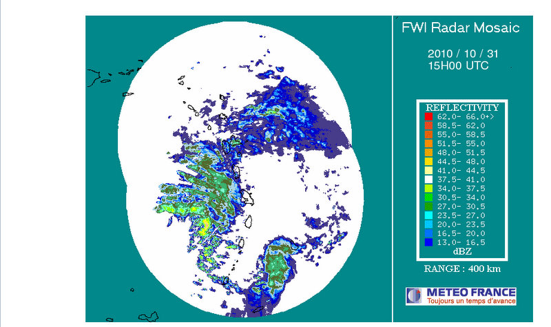
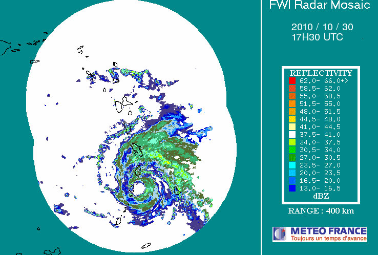
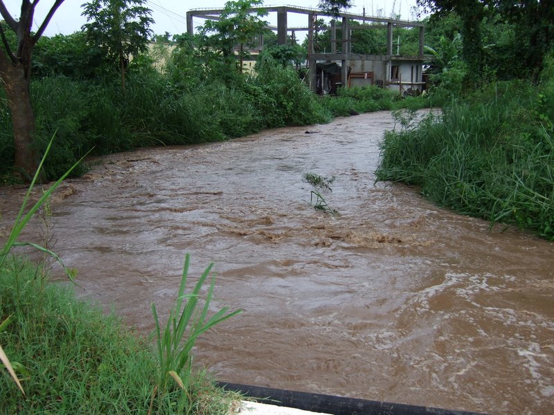
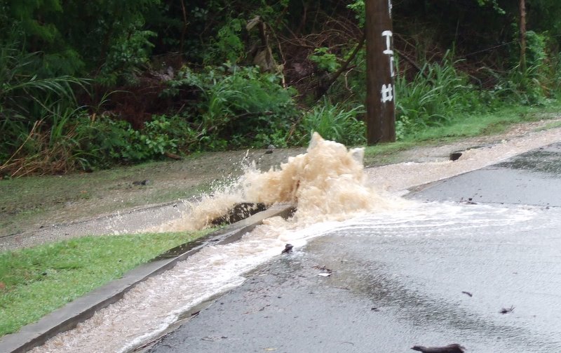
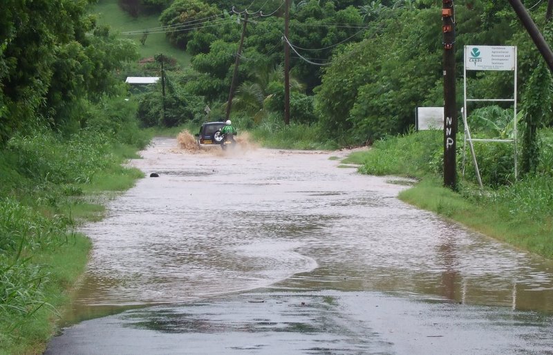
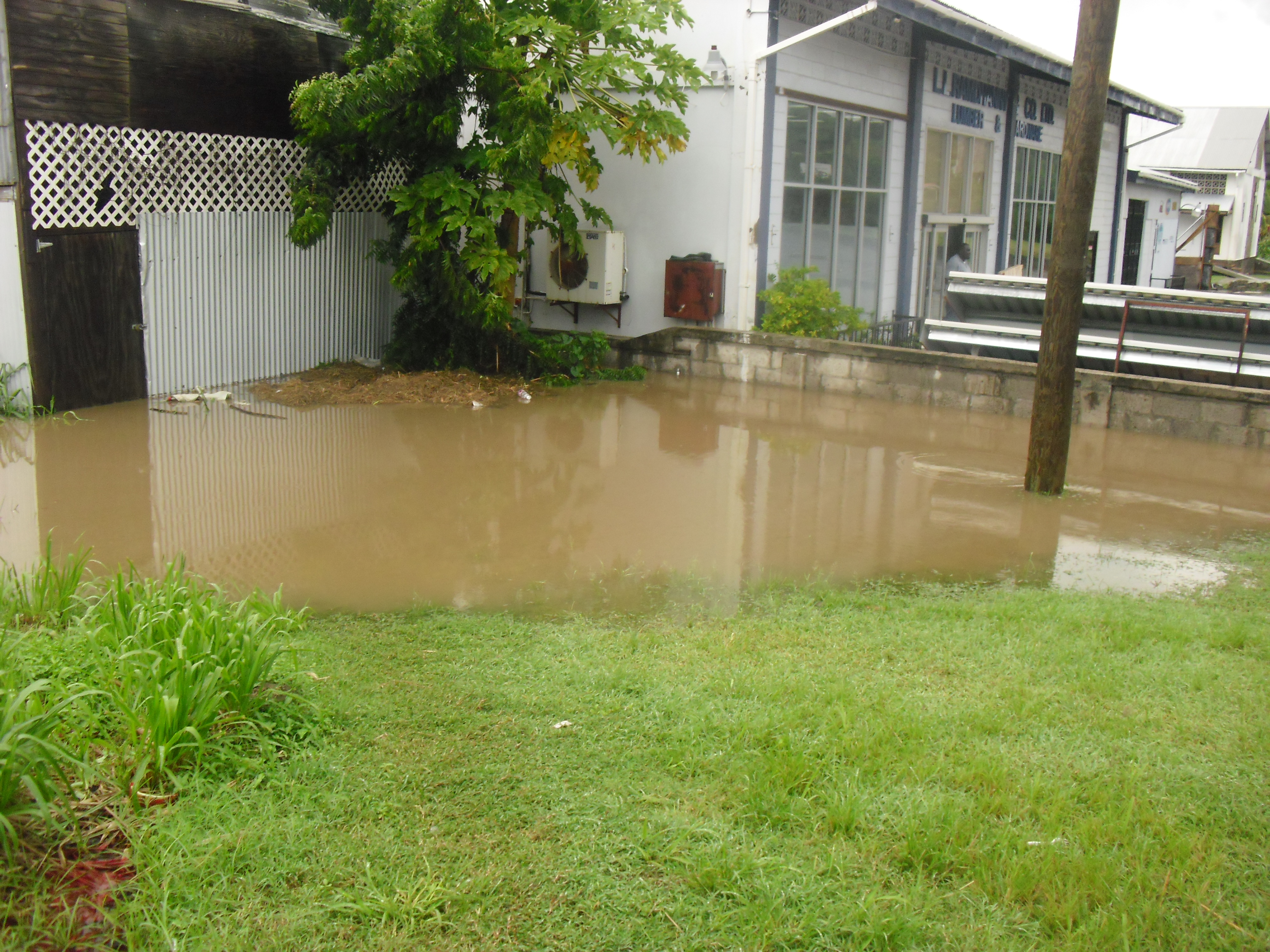
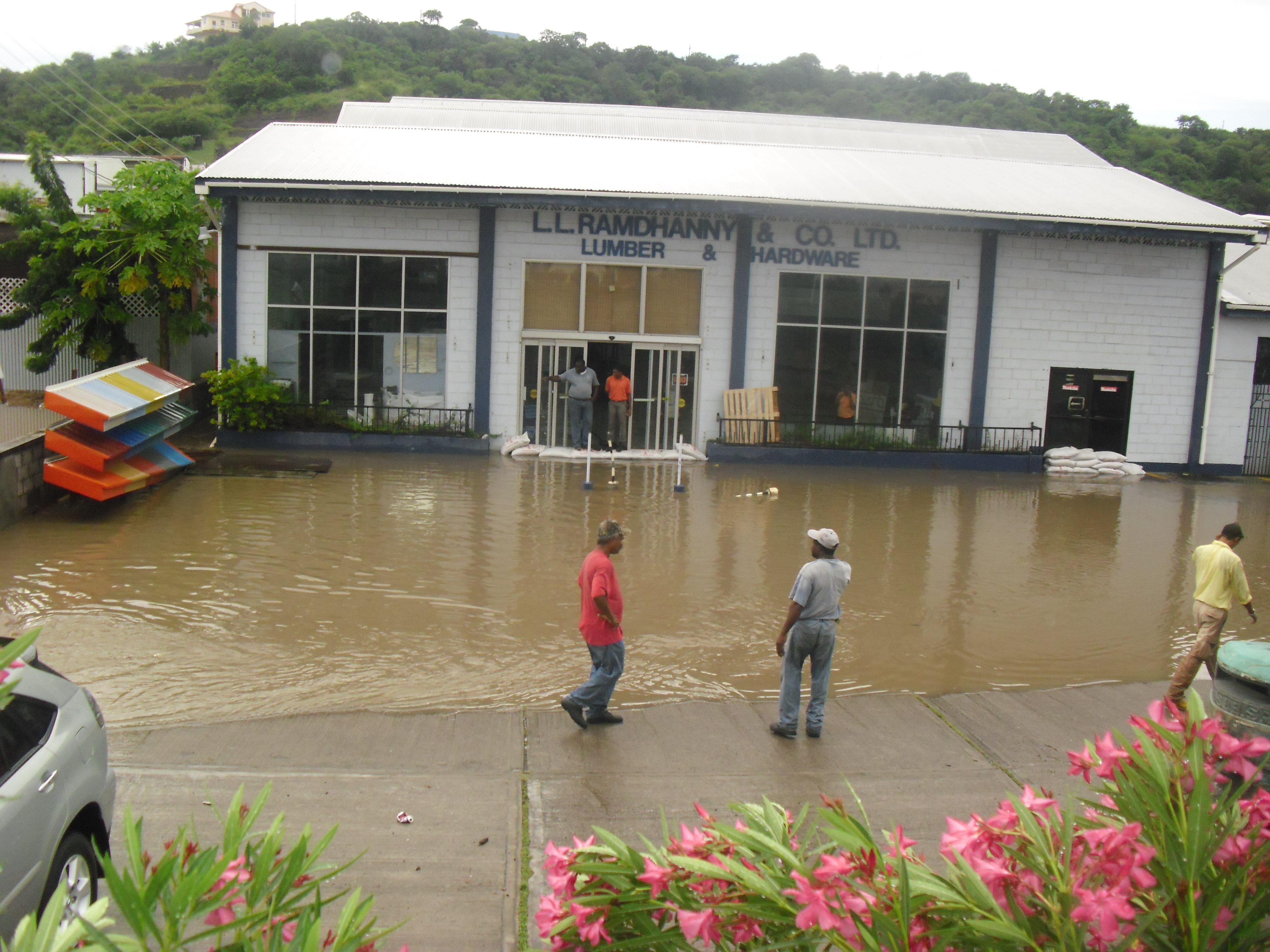
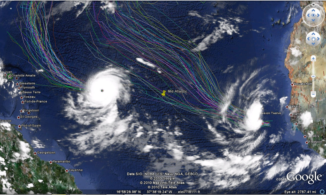
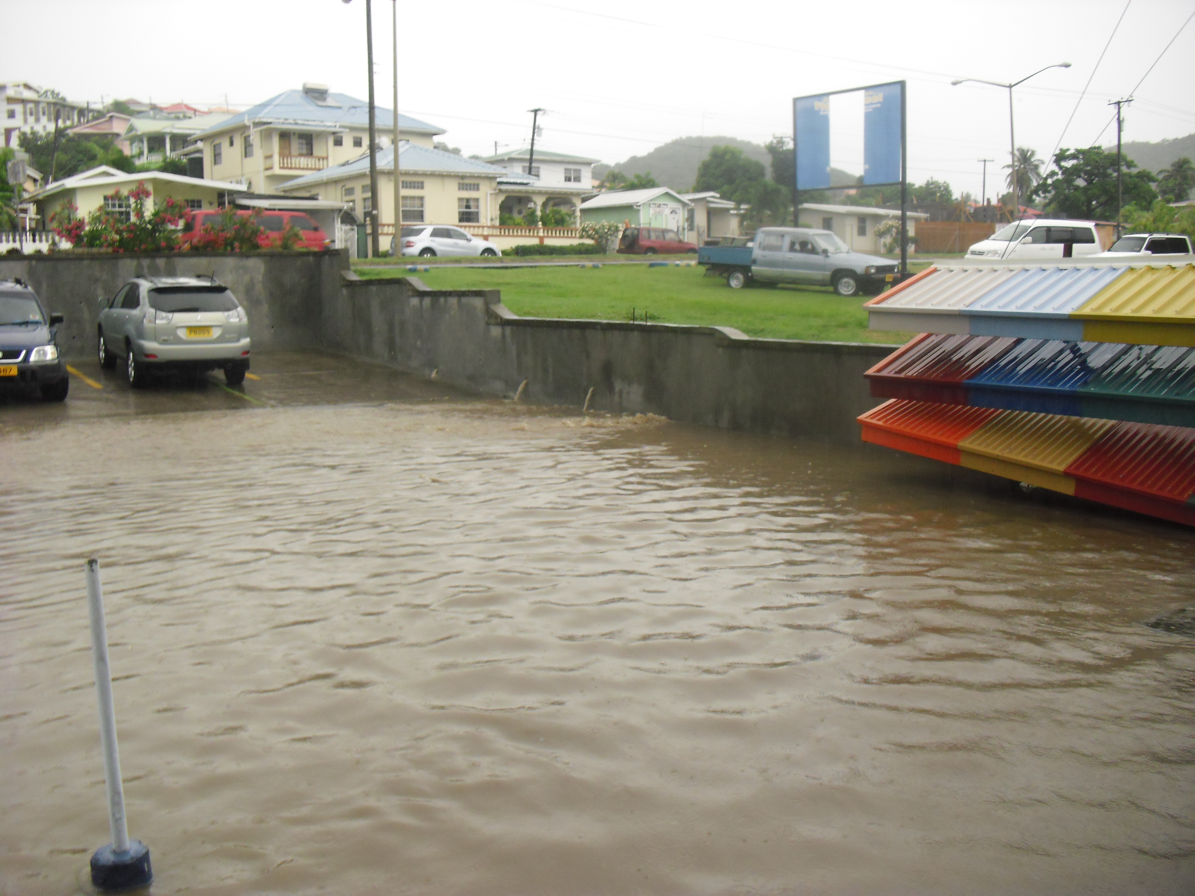
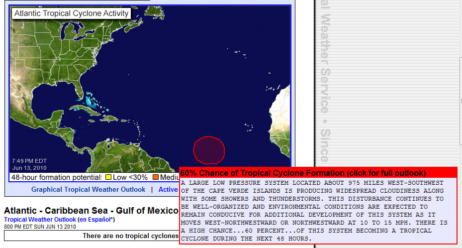