 |
Caribbean Hurricane Network
- 2 0 1 3 Season - |
|
|
|
2013 Atlantic Hurricane Season |
|
| Andrea | Barry | Chantal | Dorian | Erin | Fernand | Gabrielle | Humberto | Ingrid | Jerry | Karen | Lorenzo |Melissa | |
Despite the number of named storms (13) the 2013 Season was kind of a dud (yeah!). Can you believe that there were no major hurricanes! Most storms were weak or stayed out at sea. The biggest story was (Pacific not Atlantic) Typhoon Haiyan that killed over 6000 people in the Philipinnes... The heart of the Caribbean Hurricane Network are the personal reports send in by the special hurricane correspondents on the islands. Find out whathappened on your favority island during the 2013 Hurricane Season by following the links below.
Following is an archive of all weather discussions Dave and I posted. They are in reverse chronological order, with the most recent storm discussion on top. If you want more background in formation on specific storms, I have found the 2013 Atlantic Hurricane Season section in the Wikipedia a great resource. Also, visit the Hurricane Research Division of NOAA's Atlantic Oceanographic and Meteorological Lab for 'best track' data of all 2013 storms. The track map below is from that website as well.
- - 2013 Hurricane Tracks - -
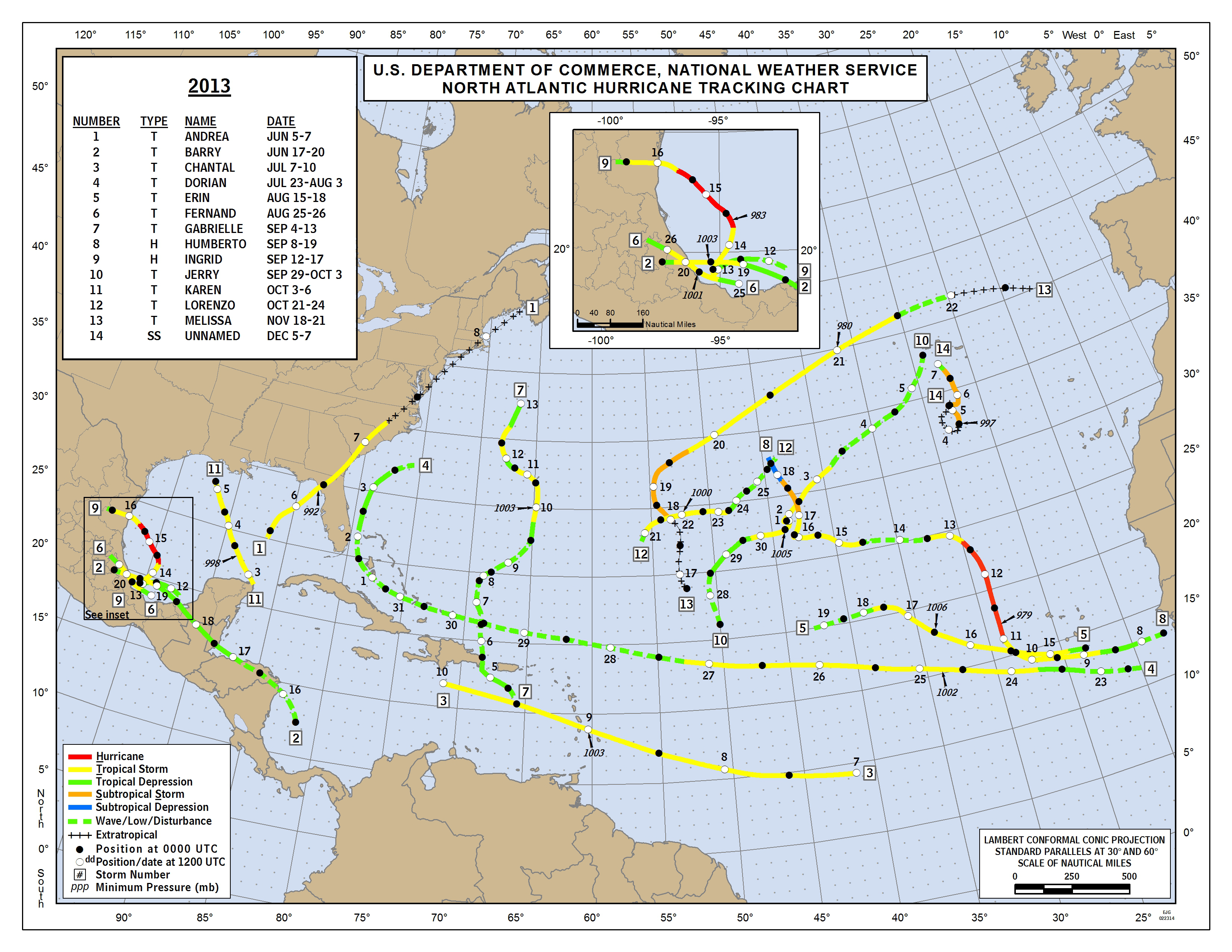
- - Source: NOAA/AOML Hurricane Research Division (click on image for larger size) - -
Weather discussions by Gert & Dave during the 2012 Atlantic Hurricane Season. The homepage with the links to local reports from the islands, latest satellite image, current weather outlook can be found here.
Sunday, December 8, 2013 09:34AM EST
- Changes
-
Good morning all!
Christmas winds arrived as historically advertised yesterday afternoon and now they are howling along. While the winds are a welcome respite from the summer humidity and heat, if you are on a boat in the open ocean, they are not your friend. Waves heights are averaging 8-10 feet with 10 second intervals and the Coast Guard already has received a sailing vessel in distress call 20 NM west of Saba. It will continue to be breezy to windy through the upcoming week. Rain will be sporadic except maybe Tuesday with mas more. There is running water everywhere still and the roads have turned into a "Whack-a Mole" game board with the size potholes we have!! St. Croix will receive additional rains though as they are closer to the trough moving west.
90L died quickly south of the Azores. I believe it made sub tropical storm status at one point and should have been named as peak winds were an estimated 50 mph according to satellite derived information. However, they are content to let this upside down 2013 hurricane season slip into anonymity with the only remarkable aspect of it being the total lack of forecasting expertise. The forecasting models and even humans need to take into account the effects and presence of the SAL Saharan Dust Level) and stability of the atmosphere.
Now, its on to the named winter storms which accuracy of forecasting is much better although not perfect. Weather is an inexact science and will continue to be for many, many years!
Happy Holidays!
Dave
Monday, November 18, 2013 15:52PM PST - Melissa and Haiyan
- Here we have a late subtropical storm in the Atlantic, Melissa. It should not be a threat to any land, nor is it expected to become a hurricane.
On another note, the situation in the Philippines is very dire. I was just reading an article by Reuters where a spokeswoman from the United Nations said "The size, the quantity of people that have been affected by this, this is massive, between 10 and 12.9 million people have to be assisted to recover from this. This is absolutely huge. It's like taking the whole of Belgium and trying to assist." Also, apparently they have not been able to reach some of the smaller islands as of yet... It is a very sad situation. If you want to donate, the Red Cross is a good option.
Reporting from Punta Arenas, Chile. Off for an Antarctic research cruise, no internet for 66 days. See you in Tasmania! -Gert
Thursday, November 7, 2013 12:52PM EST
- Haiyan
-
Good afternoon,
I am sitting in Miami International Airport looking at a monster; a totally destructive monster name Super Typhoon Haiyan which is about to hurl 195 mph "sustained" winds and 230 mph gusts at the Phillipines along with 14-18 foot storm surges. Folks, this is about as intense as it gets for a landfalling cyclone. My thoughts and prayers to this already storm battered nation.
Dave
Thursday, October 31, 2013 07:20AM EDT
- Late season Tricks!
-
Good morning all!!
A quiet season it has been as far as intensity goes and with a lack of Cape Verde storms developing due to stable, sinking air and our favorite culprit, that pesky dry Saharan Dust Layer, it appears, on the surface, that the season is virtually over. Not so fast!!
Hurricane season "officially" ends in the Atlantic on November 30th. Today is Halloween which is October 31st meaning 30 more days to go so lets see what is potentially brewing right now: nothing!
However, our friends in the Western Caribbean should be extra vigilant over the next few weeks as most of the computer models show not one but possibly two storms forming in the Western Caribbean basin and moving pretty much into the Gulf of Mexico. The SST's (sea surface temperatures) contain ginormous untapped heat energy while the MJO (a large area of unstable and active weather that circles the globe every 60-90 days) is a very enhancing factor and will be around that area for about the next two weeks while wind shear will not be a factor. No dust, no stable air, no sinking air, and abundant moisture. Once again, all the ingredients will be in the Caribbean mixing bowl but will they gel? Historically speaking this is a favorable area for development this time of season mainly due to systems forming at the end of stalled out fronts draping down from the US but occasionally forming from a wave from the east.
As usual, time will tell and most of the forecast storms this year have not verified and the ones that have were weak and short-lived. However, if one of these verifies, an angry tiger with a lot of pent up energy will be on the loose and when its loose in the Western Caribbean, it has to hit land somewhere unless it goes due west, an unlikely scenario but not unheard of (Lenny).
Off to the east plenty of moisture is evident on satellite off the coast of Africa which will work its way across the Atlantic but very disorganized and broad in nature. Here closer to home, we might see heavy rainfall possibly Friday through Sunday as 2 upper level lows form in conjunction with a surface trough (front) and hang around a while inducing a train of rain from the south. Feast or famine on the rainfall and while we need some, we don't need it all at once. Nor this weekend as two of my friends are getting married Saturday.
Stay vigilant and from Louisiana to Florida you might want to check your aging supplies just in case you dove into them this year to be on the safe side. Complacency is a bad thing.
Dave
Monday, October 21, 2013 13:42PM PDT - Tropical Storm Lorenzo
- Tropical Storm Lorenzo formed a couple hundred miles east southeast of Bermuda. It will probably be short lived and not threat to any land. So no worries here. Things are different in the Pacific with major Hurricane Raymond threatening Mexico and Typhoon Francisco heading for Japan. The picture below is from Francisco (source: CIMSS Satellite Blog! Very scary. More info on Jeff Master's Wunderblog.-Gert
Tuesday, October 15, 2013 09:47AM PDT - Tropics extremely quiet in Atlantic
- I love these kind of headlines! The only other year in recorded history in which no major hurricanes occurred in the Atlantic or the East Pacific is 1968. Read more on Brian McNoldy's blog post. And Invest 98L is no more either!-Gert
Sunday, October 13, 2013 09:12AM EDT
- Stretched
-
Good Sunday morning all!
Halfway between the coast of Africa and the Windward Islands is 98L, an area of interest to the National Hurricane Center, The Weather Channel hypists, and, of course, us here in the Caribbean. Looking much better yesterday than today, 98L is fighting higher wind shear and dry air entraining itself from the north. The pundits give it a 10% chance of tropical formation and I must admit it is fighting for its very survival as an "invest".
Expected to move north of the Northeastern Antilles, my opinion is that it will come through the Northeastern Antilles, if not a bit farther south due to the trough digging in from the north. If 98L had developed by now, this would be a different scenario as a stronger system would have taken advantage of the earths rotation and spun more to the NW. Instead, the weaker system, still classified as a tropical wave, will push more to the west than NW. A weaker system is also less likely to be picked up by a steering front or trough and recurved out to sea to be a fish storm. The steering currents are at the higher altitudes. If this has no high cloud tops and development, it goes where it wants to go which is riding the low level trades.
Expect some decent rains from 98L Wednesday, maybe Thursday depending on forward speed. Development for the next few days will be tough due to hostile wind shear but if it survives the next three days, things could get mighty interesting.
Behind 98L is another, lower tropical low which has not been discussed by the NHC. Interesting to watch too seeing 98L is plowing the road, taking the wind shear hits, and moistening the path ahead. In addition, SST's (sea surface temps), which is the fuel for these systems, is readily available and hasn't been tampered with in hurricane eons.
Home, here in the USVI, we definitely can use the rain as Isabel said from St. Croix. My cistern is starting to grumble after gulping up the copious rainfall of 5 weeks ago. Watching the scattered, heavy and slow moving rain showers fall all over Jost Van Dyke in the BVI's and St. John the last few days while, just a mere 4 miles away across Pillsbury Sound, I watch with drooling anticipation, has only wetted (no pun) my appetite and my cisterns.
Have a great rest of the weekend!
Dave
Thursday, October 3, 2013 08:42AM EDT
- "Home Grown" TS Karen
-
Good morning all!
Well, she took her good old time getting it together but "home grown" TS Karen, formerly known as 97L, has finally been spawned in the SW Caribbean and is headed for the an ultimate showdown with the Gulf Coast because, after all, when it gets in the GOM, it has to hit land somewhere.
Skipping depression status, Karen is experiencing good ventilation with low wind shear and very warm sea surface temperatures. That's the plus side for her. The downside is dry air entraining into the storm and passage over the western part of Cuba and the Yucatan which will slow down her intensification efforts. Definitely, a ying and a yang. Wind shear is expected to increase in the next 48 hours as well providing further hindrance.
Current forecast track show a cold front and trough of low pressure approaching the system Friday/Saturday which should turn Karen more towards the NE and on a collision course for the Fla Panhandle. Due to the obvious unpredictability of a caged animal, Karen can strike anywhere from the upper Texas coast to the Big Bend region of Florida which means New Orleans as well. We will have to see further model runs and data from the hurricane hunters to get a better grip on Karens intentions.
Intensity forecasts do not subscribe to Karen obtaining hurricane status but I believe she can reach Cat 1 before landfall. Unless the wind shear intensifies, those very warm, almost thermally congenial waters, will do their duty and fire up the engine that Karen is now feeding off of.
TD Jerry is still fishing in the central Atlantic; a harm to nothing and no one.
Off to our east, several weak tropical waves are crossing the Atlantic and a low should exit the African coast in the next day or so. It's getting very late in the season for any Cape Verde systems to make it but you never know. Still, there is 7 1/2 weeks left officially.
Dave
Wednesday, October 2, 2013 14:41PM PDT - Karen in the making?
- The disturbance that caused lots of rain in Jamaica is now passing over the Cayman Islands. It is moving to the northwest, towards the Yucatan Peninsula. It might become Tropical Storm Karen by tomorrow morning, our eleventh named storm only.
We have been lucky so far this season. I read an interesting article the other day by Brian McNoldy, posted on the Washington Post-website on "What happened to hurricane season? And why we should keep forecasting it...". Too much dry air apparently, and hurricane activity is actually down on the Pacific side as well. The Cayman Updates page is very telling, there was one 'check-in' post on June 1, the beginning of hurricane season, and the only other one was posted yesterday! In any case, hurricane season last through November, it is not over yet! -Gert
Monday, September 30, 2013 14:01PM PDT - Tropical Storm Jerry
- Tropical depression Eleven was upgraded to Tropical Storm Jerry. It is located in the central Atlantic and not expected to reach the islands (or any land for that matter).
On the other hand, there is a broad area of low pressure south of Jamaica. It has a low chance of becoming a tropical storm. However, this large area of disturbed weather is moving quite slowly to the northwest, therefore lots of rain is expected for Jamaica (sorry Gloria!) and the western tip of Haiti and the Cayman's later on. -Gert
Thursday, September 26, 2013 14:27PM EDT
- Blob up!
-
Good afternoon all,
Other than being hot and humid but dust free, the last week has been bereft of organized activity and even a decent rainfall for that matter over the Eastern Caribbean Islands and Eastern Northern Antilles. Atmospheric changes are afoot and an active October is probable although this season has been the quietest in many years and that is a good thing!
Almost due south of Jamaica lies a blowup blob of convection with very heavy rains on and off the northern coast of Columbia stretching slightly to Panama and Venezuela. This is expected to move predominantly northward but does not draw any attention from the NHC or TWC in terms of potential development. regardless, Heavy rains will fall in this systems path if it holds together.
Off tour east, what was tranquil a few days ago has virtually blown up overnight into a ginormous, stretched out, tropical wave interacting with an upper level low. Last night and early this morning no development was anticipated but now, there is a 10% chance from the NHC. The core is moving northwest for now with dry air ahead and wind shear to the south. Not anticipating any organized system to affect the islands but rain is in the forecast for late Sunday and Monday.
Still, many surprises have occurred this season already so guard should not be let down anytime soon. This is the best mess we've seen in a while and maybe a precursor of October.
Dave
Thursday, September 19, 2013 11:28AM EDT
- Really, its mid-September?
-
Good morning all!
First lets check out the Western Pacific where Super Typhoon Usagi at 160 mph sustained and 195 mph gusts is scheduled for a date with the southern tip of Taiwan Saturday noonish before heading towards a close encounter with Hong Kong as a weakened but still battering cat 2 or even 3 system. Right now, it is almost as perfect as a typhoon (nomenclature: same as hurricane in the Atlantic) as it can be. If this hit Taiwan directly, the devastation would be ginormous even though they are well prepared. Passing that close anything can happen though. Just a slight wobble north would be all it takes.
Eastern Pacific wise, TS Manuel continues his stubborn trek into Mexico dumping copious amounts of rain resulting in flooding and continuing loss of life. This is his second landfall, having flooded Acapulco already. On the Atlantic side of Mexico, its 95L menacing the populace with the potential to reach depression status if it stalls. While it is possible 95L could get picked up and turned NE towards the gulf coast, the probabilities are less than they were yesterday. Definitely, this area of Mexico does not need any more rain.
Across the Caribbean and out into the central Atlantic, TD Humberto is lumbering around with nothing better to do and is expected to become extra tropical shortly and head for a date with the Euro.
The rest of the basin is quiet with a few waves marching across but not expected to turn into anything right away. Around 53W is an area of interest as another around 30W. The African continent is pretty much devoid of wave activity; very unusual for this time of year.
Still, there are 2 months and 11 days left officially. Lots of time.
Dave
Wednesday, September 18, 2013 11:25AM PDT - Mexico sandwiched and more to come...
- I was planning to write earlier about the dire situation in Mexico. The country got attacked simultaneously from the Pacific and the Caribbean side by tropical storms Manuel and Ingrid! The massive rains did cause flooding and mudslides. At this point at least 42 people have died. To make matters worse, Invest 95L, located near the Yucatan Peninsula is becoming a bit more organized and may pass very close by the same area as affected by Ingrid. Let's hope Mexico is getting a break. Read more at Google News. -Gert
Friday, September 13, 2013 08:37AM PDT - Three storms!
- Well, it must be the peak of Atlantic Hurricane Season since we have three active storms. The best part is none of them are any threat to the Caribbean! Hope it stays that way but the season is still long... Stay alert. -Gert
Tuesday, September 10, 2013 22:34PM EDT
- Lots left!
-
Good evening all!
TS Humberto, already at an estimated 70 mph and eating Saharan dust from several angles, should still achieve hurricane status but will he beat the clock or set a new record for latest hurricane formation in any year since records have been kept? If he does at the 11 pm advisory, the record remains safe. If not, his name will be in the record books even though he will not have menaced any landmass other than the Cape Verdes which he basically skirted. Right now, a 4 mph difference in wind speed will be a judgement call by the NHC.
Trekking to the NNW and then North, Humberto is expected to take a "left turn Clyde" and head due west late Friday night/early Saturday morning. An improbable journey across the Atlantic follows likely leading to his demise. Anything is possible though.
I did mention Gabrielle and Bermuda in a prior post. TS Gabrielle, another Phoenix arisen, is taking virtually dead aim at Bermuda, an island which has strict building codes and a well seasoned populace for dealing with tropical systems, much like Guam in the Pacific, a concrete bunker jungle built Ram tough! Closest point for now says 17 miles but for a TS with TS winds extending 115 miles, this is, in reality, still a direct hit close to 3 am. Beach erosion, flooding, and flying debris should be the damage assessment unless RI happens (rapid intensification) which is highly unlikely.
A tropical wave close to 53W will make an appearance around the northern islands this weekend with a 1012mb low attached at the northern end. No worries now but another entity to watch.
93L should reach TD status before plowing into an already hit twice area of Mexico south of the Texas border. However, this time, some beneficial rains should reach southern Texas.
The forecast is for less activity the next few weeks due to another dust plume off Africa and too much stable, sinking air. A good forecast. But....
It takes only one. This is a recording.
Dave
Tuesday, September 10, 2013 07:06AM PDT - Gabrielle is back, watch out Bermuda
- Convection has increased over the remnants of Gabrielle (Invest 92L), esp. the eastern part. In addition, a satellite measured high enough winds to warrant an upgrade to Tropical Storm Gabrielle. The center is expected to move very close to the west of Bermuda in about 16 hours. But since most of the convection is to the east Bermuda will be in de midst of it. Luckily it is expected to stay a tropical storm, which 'The Rock' can handle with no problem. Use the tools above to how close it can get to you and more. -Gert
Monday, September 9, 2013 18:26PM PDT - Humberto
- And as expected, the tropical depression in the far eastern Atlantic has been upgraded to tropical storm Humberto. It might even become our first hurricane of the season! It is moving away from the Cape Verde islands so is no threat to any land at this time. The Invest I was talking about yesterday that could have posed a threat to us in the Caribbean has disappeared from the satellite images, at least I don't see it anymore! However, the remnants of Gabrielle still have a 50/50 chance of becoming a tropical storm again. So Bermuda, keep an eye on this one. -Gert
Sunday, September 8, 2013 09:40AM PDT - Three invests and no storms
- Looking at the climatology we are at the peak of Atlantic hurricane season. For the Eastern Caribbean the peak is actually the first week of September. Luckily there are no active storms, however there are three 'invests' (see above). Invest 92L is what is leftover of Gabrielle and is moving away from the Bahamas. Invest 91L just came of the African coast so is located in the far eastern Atlantic. Although it is expected to become our next named storm, and might even become a hurricane, it will most likely not affect us since it is moving to the west-northwest. The Cape Verde Islands however will feel some effects. Finally there is 98L, a tropical wave about half way between Africa and the Islands. Right now it doesn't look like it will develop into a tropical storm, however, it is expected to trail towards the islands, although it seems to be not moving much. So no storms, but lots of activity! Stay tuned... -Gert
Thursday, September 5, 2013 23:34PM EDT
- Poof goes Gabrielle!
-
Good evening all,
TD Gabrielle lived a brief life but her legacy will be copious amounts of rainfall and resulting flooding as eastern PR, Vieques, Culebra, and the Virgin Islands, especially northernmost, are getting hammered by rainfall rates radar estimated at 2-3 inches per hour. The easternmost portion of the Dominican Republic has seen some rains as the former center of Gabrielle is now about 30 miles northwest of Punta Cana at this moment but since most of the convection has been to the east of the center, they have been largely spared.
A flash flood warning is in effect for St. Thomas and St. John until 1 am as a result of persistent heavy rainfall, including thunder and plenty of lightning. St. John is a mere 4 miles away and I've seen its lights once since 8:45pm. Thats how heavy the rainfall is. The towel brigade had withstood the initial onslaught quite well as I observed upon returning home but since then, all available reinforcements have been called to active duty, some which haven't seen action in several years. Even my pump was, and still is, temporarily overwhelmed as it could not keep up with the rainfall rate. Seepage is an insidious creature.
More rain, albeit lesser in intensity, is expected tomorrow through Saturday at least due to the systems stubborn refusal to pick up speed and vacate the premises. I know many of my marine friend live aboards are suffering from dinghybutt right now and would do anything to feel a dry spot on their body.
Power. a/k/a WAPA has only gone off once here on the east end which is miraculous in itself but there have been many flickers. Satellite TV is smothered by heavy cloud cover for those who have. Other portions of St. Thomas have been out of power for a while. Expect more of that the next few hours.
Future plans call for the soaking remnants of Gabby to merge with the tropical wave which actually destroyed her as a Tropical Storm. The resulting merger is not really expected to develop as upper level winds will be hostile along with mid level dry air. Still, any island in the path will expect a serious soaking.
Have a safe and for most, a dry night.
Dave
Thursday, September 5, 2013 09:53AM EDT
- TD Gabby again?
-
Good morning all,
3:30 am did come early! LOL
Anyway, I am posting this as by the time the next advisory makes it out I should be in the air again. TS Gabrielle looks to have a closed, yet elongated COC (center of circulation) but, with most of the heavy convection located on the eastern half of the system, she looks to be relegated to TD status at 11 am unless the NHC decides to not pull the plug yet.
The western portion is pretty devoid of thunderstorm activity and, for now, central and eastern PR, Vieques, Culebra, and the Virgin Islands have born the brunt of the heavy rain and lightning shows with still more to come as the system slowly moves NW. I'm sure my platoon sized towel brigade I left to hold the fort has been overwhelmed but they have stood like Sparta before! We'll see when and if I get home tonight. More rain for the weekend is expected as leftovers from Gabrielle and the wave to her east continue the march.
Still forecast to pass through the Mona Passage tonight and into the Turks and Caicos, Gabrielle, which even might get knocked down for the count, is expected to bypass most of the Bahamas and pass east of Bermuda.
98L has regenerated as an area of interest but will remain a fish storm. 99L might make TD status before plowing into Mexico with heavy flooding rains while the next wave is poised to exit the African coast.
Still no hurricanes as of yet but be careful what you wish for!
More later depending if I get stuck in Miami tonight or not.
Dave
Wednesday, September 4, 2013 22:06PM EDT
- Update TD#7
-
Good evening all,
Have to rewrite as internet poofed as I was sending and lost the post. Ouch!
TD#7 should be declared TS Gabrielle as of the 11 pm NHC advisory. The Governor of Puerto Rico has declared all government offices and schools closed tomorrow. On its current forecast modular track, Gabby will pass over the western part of Puerto Rico, navigate the Mona Passage, clip the tip of the Dominican Republic and arrive in the Turks and Caicos Thursday night.
A minimal TS, Gabrielle should remain well below hurricane strength until passage to the T&C. Heavy rains will be the main threat along with the obligatory flooding from its 3-10 inches of rainfall. Interacting with Gabrielle is an assassin sneaking up from behind. This invest wave has the potential to destroy Gabrielle as it sucks the energy from her as it rushes up from the east northeast. So, Gabrielle could become a very short lived tropical storm.
Much remains to be seen during the overnight hours ahead. If Gabby strengthens, she could turn to the right a bit quicker, hammering PR but sparing eastern Dominican Republics resorts and people from serious flooding rains, but if she remains weak, her forecast track for now should verify.
This is a difficult storm to forecast, mainly due to the proximity of the very menacing tropical wave on her heels. Again, the overnight will speak volumes.
Bermuda should be watching this scenario unfold with a keen eye.
Be safe!
Dave
Wednesday, September 4, 2013 21:54PM EDT
- Update TD#7
-
Wednesday, September 4, 2013 16:42PM EDT
- TD#7
-
Good afternoon all,
TD#7 is hatched SSW of Ponce PR. Look for TS status before long.
More later!
Dave
Wednesday, September 4, 2013 12:02PM EDT
- Consolidation
-
Good morning all,
This will be quick as I have to get on the road to the airport to hopefully get back home tomorrow. I fear the towel brigade I left as guardians
and protectors need reinforcements!
98L is no more. The African continent is strangely quiet with only a few puffs of wave white showing up on satellite. We do have a wave ready to exit the coast and will be ripe for development but is expected to be another fish storm.
The attention span is concentrated on 97L, soon to be a TD, southeast of San Juan Puerto Rico, Already heavy rains have been experienced in the Virgin Islands, PR and the down islands as it passed through. Looking pretty impressive for the moment, it is devoid of a closed circiulation at the surface, hence still 97L status. Heavy rain with life threatening and property damaging potential will occur over the Virgin Islands, PR, and the Dominican Republic today, tomorrow and Friday as 97L slowly moves WNW around 10 mph. If it does develop it will likely be picked up by the trough coming offthe coast and turned out to sea possibly menacing Bermuda. Time as always, will tell.
The tropical wave behind 97L could become 99L soon as 97L has been the vanguard of moisture enhancement. In addition, this wave is moving faster than 97L and could interfere with its development. This could get interesting. Either way, its a 1-2 punch for the northern islands.
The Bay of Campeche has some action but this system is running out of time before plowing into Mexico with heavy rains as well.
We still have 1/2 a season to go with 69% of the historical tropical energy in that second half. Stay vigilant my friends!
Dave
Thursday, August 29, 2013 10:07AM EDT
- Slow but brewing
-
Good morning from warm and muggy upstate NY!
While in NY or wherever I am, I still watch the tropics when the chance arises and, of course, when I have internet service! And, it figures the season starts to heat up when I leave home (US Virgin Islands)
The stage is finally set for the season to kick into high gear but will it and where? Conditions right now are pretty favorable in the Atlantic
Basin but yet, not one of these foot soldiers of the waves has decided to pick up their "standard' a/ka/ battle flag, wave it, and charge.
Instead of being the vanguard of high season, they act like the rear guard in November. Mind you. I am not "wishcasting" just stating a fact.
The wave close to 60W has pretty much wimped out convection wise and is a split with the northern leg at northern Leeward Islands level and the southern leg at Barbados level. The southern portion could be a player in the western Caribbean down the yellow brick road. Another pretender is at 45W and has some potential but this one too looks wimpy. An area of low pressure (1013 mb) is south of the Cape Verde Islands and in a moister environment while the next wave is due to exit the African coast on Friday and some models spin this one up but likely recurvature will happen due to its higher latitude take off from the African runway.
The wave behind that one, ETA Atlantic Basin Sunday/Monday, is a humdinger already, one of the largest so far this season. With the scouts out front plowing the driveway, clearing the dust and ensuring plenty of moisture content in the atmosphere, this division sized wave could have a major impact in the upcoming few weeks. As always, time will tell.
The SAL (Saharan Dust Layer) has weakened as it usually does this time of year although plenty of dry air in its wake still exists to the north. Most moisture is consolidated to the south and along the monsoon trough so anything that tries to develop low will stand a much better chance than its predecessors. Winds from the east are enhancing rising air, which is conducive for development and the SSTs (sea surface temperatures) are as well. Wind shear is low until you get to the Antilles, plus the MJO will be in the area soon (enhanced area of thunderstorms which circle the globe every 30-60 days) and this is a very conducive contributor.
So, with that said, I remind you the stage is set. Will it be a "home grown" (GOM or SW Caribbean) storm that starts the cascade of tropical genesis, will it be a CV (Cape Verde) spawned system, will it be a "Oh crap its on my doorstep system" 300 miles from the Eastern Caribbean, or will it happen at all? Truth is, there will be storms in the next 3 months or 1/2 of the season remaining. Yes, 1/2! Vigilance needs to be maintained even though complacency is rearing its proverbial ugly head. We should see action soon. Somewhere.
Happy Labor Day weekend!
Dave
Sunday, August 25, 2013 17:02PM PDT - Tropical Storm Fernand forms
- Tropical depression Six strengthens into tropical storm Fernand. It is located in the Bay of Campeche and is very close to making landfall in the state of Veracruz, Mexico. This will therefore be a very short lived storm, but still able to produce massive amounts of rainfall, so stay safe!
Also, a tropical wave just came off the African coast and has some potential to organize into something. It is getting closer to the height of hurricane season... -Gert
Tuesday, August 20, 2013 08:14AM EDT
- Dry and Stable (for now)
-
Good morning all!
As I sit here drinking my coffee this morning, I am amazed at the number of people who a.) are "wishcasting", which means they are wishing for a hurricane or TS, and b.) the number of people who are of the "naysayer" persuasion. I find so far both of these groups are in the majority with only a few still believing we will have an active storm year. The fact the computer models have a hard time factoring in the SAL into their programs and forecasts is of no help either as its lead to the "chicken little" syndrome.
Technically, we are ahead of the game right now with 5 named storms so far and we have just entered the historically high period of each season which will last 6-7 more weeks. Granted, there have been no hurricanes so far this year but the SAL level cannot last forever.
It's obvious the main reasons for the lack of tropical cyclogenesis is 2 fold: The omnipresent SAL, which has pretty much coated the Atlantic Basin from the African continent to the Caribbean, Bahamas, and even Florida plus, an unmoisturized stable air pattern. While much thinner than it has been as is expected this time of year, the SAL has hung around longer than usual and its tentacles have reached far south as well. The fact the ITCZ has stayed south hasn't helped either, further contributing to the dry, stable situation.
CV storms will occur eventually and the fact one hasn't already is no reason for complacency. When one does form, unless it does at a high latitude, the chances of recurvature will be severely diminished and a rough ride will ensue for someone down the road.
This also leads to the theory of "home grown" storms; those that form in the Caribbean or the Gulf of Mexico. For this years purposes, that theory is very real.
Closer to home here in the VI, a wetter weather pattern has set up as we have had several troughs, low level pertubations, a few TUTT's (Tropical Upper Tropospheric Troughs) which ride the fence as they can both help and hinder tropical formation, and the ITCZ moving more northerly in our direction.
Yes, it has been quiet here in the Atlantic; unlike the Pacific which has been very active as of late. Don't let it fool you. It only takes one.
Dave
Thursday, August 15, 2013 13:57PM EDT
- TS Erin and beyond
-
Good afternoon all!
During lunch I had the opportunity to review TS Erin, 92L, the wave at 40W, and the waves on the African continent. Here is what I can see based on what is happening now.
TS Erin: Yes, it is a minimal tropical storm and should strengthen a bit over the next two days while climbing slowly WNW. I agree with the models forecast intensity in the short run but there are several factors which will decide whether this TS becomes another Dorian or not. Dry air, cooler SSTs and a pulling away from the ITCZ.
The other part is forecast path. Out so far from the islands, the margin of error is 300 miles+. As of right now, on its forecast path TS Erin would pass close to our north on Fri/Sat next week, if it survived the trek through the hostile period. Possible hurricane? Maybe. Possible non survival and relegated to an open wave? Possible too. It is just too early to tell with accuracy. Bottom line is be prepared anyway.
92L: After a night of collapsing thunderstorms and waning convection, a good flareup has 92L close to depression status but not until after crossing the Yucatan Peninsula into the southern GOM and outer Bay of Campeche. As it is not a closed circulation system yet, models are all over the place. One has the Florida panhandle, one the Tex-Mex border, and one the Tex-La border. Until it closes off, this will be a mess of a forecast. Either way, tons of moisture will be working its way northwards, mainly southeastwards. However, possibility here is a split system with one going to Fla and one to Tex-Mex. After the Yucatan is crossed, we will have a much better podium to view 92L from.
40W: This wimpy wave has flared up today as well and is in an area for possibilities. Closer to home, it needs to have a watchful eye.
African continent: The waves currently in the Atlantic, along with TS Erin, are moistening up the conveyor belt and our headliners will soon be rolling off the coast. The next wave is very impressive already and will probably make a name for itself too. Several more are close behind and we shouldn't see a slow down from this shotgun till end of September.
If your not ready now, you better get it together.
Dave
Thursday, August 15, 2013 08:43AM PDT - Tropical Storm Erin
- And here we have the fifth tropical storm of the season, Erin. It is still far east, close to the Cape Verde islands. It is actually quite unusual to have a tropical storm this far east this early in the season. The big question is, is it coming for us? The models don't agree well, some predict it to become a fish storm, bending northward, and others have it move straight for us... The official National Hurricane Center forecast is actually taking the 'coming for us' path, against the majority of the models. On the plus side, it is still days away so a lot can change, and better yet, conditions ahead might not even make this storm a hurricane. We will see what happens. We are all well prepared for this, aren't we? Use the tools above to see how close it can get to you and more. -Gert
Wednesday, August 14, 2013 22:44PM EDT
- TD#5 correction
-
That was SSE of the Cape Verde, not SW.
Dave
Wednesday, August 14, 2013 22:21PM EDT
- TD#5
-
Good evening all,
Breaking news: As I posted previously, I expected some action by the 21st and it's happening now.
TD#5 has been born, the proud sibling of 93L, SW of the Cape Verde Islands. Approx. location 13.8 N, 23 W. Winds estimated at 35 mph with a 1008 mb low. Best track is west-west northwest at 17 mph.
I actually expect this to become TS Erin tomorrow morning.
Over by the Yucatan Peninsula, 92L continues to get its act together as well but does not have a closed circulation at this time. Convection has waned but should flare back up overnight. Look for TD#6 tomorrow sometime, probably by 2 pm.
I'll have more on both systems in the morning. The northern Gulf of Mexico from mid-Texas to the Fl panhandle should be on the alert as a hurricane is a possibility. Flooding is a definite.
Dave
Wednesday, August 7, 2013 07:52AM EDT
- About to heat up!
-
Good morning all,
Just a note to start off Wednesday morning. While there has been a lull in the action and that is not a bad thing, the time has come for the "meat" of the 2013 Atlantic hurricane season to go from very rare to medium. It is quiet now but the wind shear is relaxing, the SAL dust is lessening in our developmental areas, the ITCZ has moved to a more northerly position and the MJO ( Madden-Julian Oscillation which is the major player in tropical weather fluctuations and is an eastward moving "pulse" of cloud and rainfall near the equator that typically recurs every 30 to 60 days) is set to move into the western Caribbean perfectly in time for the onset of high season.
Unlike last week, the African continent has become quite active with monsoonal rains propagating from east to west and we have several decent waves about to emerge from the coast with an already small, yet cohesive wave just off the coast. The SW Caribbean basin has also moved into a more favorable position for TC development while the Gulf is still a bit hostile.
Long term computer models show development by the end of the month and even though long term forecasting is subject to many variables, I have to agree. We'll probably see something develop either in the SW Caribbean and/or have a Cape Verde spawned TC on our hands somewhere between now and the 21st. The SW Caribbean system would move, based on conditions now and forecast, in the general direction of Texas/Louisiana. For Texas, if it verifies, it could be a drought buster. For Louisiana, it could be plenty of flooding. The Cape Verde system depends on how high in latitude it develops and how quickly. Slower development and lower latitude mean a more westward track and potential Caribbean impact. The opposite means a very likely "fish storm" which implies recurving out to sea affecting no land masses.
Even then, if nothing happens by the 21st, that's good. The bad is there will be 7 more weeks of high season to go after and 6 more weeks after that of "anything can happen time".
Dave
Saturday, August 3, 2013 16:28PM EDT
- Incomplete set
-
Good afternoon all,
Dorian, this years Jester of the Atlantic, has resurrected himself but this phoenix will not live to reach puberty as wind shear and a trough will collaborate on it eventual and terminal demise. Dorian, not the most impressive of tropical systems by any stretch of the imagination, nonetheless confounded amateur and professional forecasters alike from the get go. It wasn't even supposed to become a tropical storm in the first place but managed history in the form of the second easternmost forming system in the month of any July. I can only say I'll eat a little crow, served cold of course, since he didn't make it to become our first hurricane of the season but it wasn't that he didn't put out the effort and if the wind shear wasn't as prevalently high, things would have turned out far different. Fortunately, they turned out how they did and hopefully some good lessons were learned such as the age old caveat "It ain't over 'till it's over!"
The GOM is quiet and a bit hostile for development as is the SW Caribbean. Off to the east, here in the eastern Caribbean and almost all the way to the coast of Africa, we are engulfed in a heavy and wide swath of Saharan dust; literally a "suffocant" of any tropical waves even thinking about making a name for themselves. However, this week, the dust should be moving on, settling, and a clearing atmosphere will start to return. SSTs are a tad lower from this dust as well as it inhibits complete sunlight absorption by the sea surface plus as it settles on the surface, acts as a reflectant. But, the sea cleanses itself like the atmosphere so it looks like our peaceful, tranquil time in the Atlantic will be over. In addition, the ITCZ is moving farther north finally, further enhancing moisture content above 10N.
A couple of very weak waves are evident at the moment but they are what they are in this case: very weak. A decent one is just moving off the coast of Africa at a higher latitude and in an area less "dustfull". That and the ones to follow will be the ones to watch for the next 6-8 weeks. On the African continent, there are only a few waves at the moment and none formidable as of yet.
Have a great first week of August!
Dave
Monday, July 29, 2013 08:25AM EDT
- Lining up!
-
Good morning,
Ex-Dorian continues to lurk north of the Virgin Islands and Puerto Rico but is having minimal effect on our weather with the exception of some high debris clouds and some 9 1/2 foot seas in the Atlantic offshore waters. A few steady showers lingered last night and WAPA flickered a few times but managed to stay on although DISH couldn't see through the clouds all night.
The chances remain ex-Dorian will refire down the road and even the west coast of Florida might want to pay attention. It's not crow time yet!
Off to our east conditions are pretty tranquil as they historically are this time of season but that, my friends, is about to change. The reasoning: SAL levels are diminishing, SSTs are warming up, the east jet from Africa is slowing down, and the ITCZ (Inter Tropical Convergence Zone) which is the belt between the northern and southern hemisphere around the equator, is lifting which will provide more instability to the region. The foot soldiers of the hurricane army are arranging themselves in battle formation and are about to engage the Atlantic as seen via the African continent satellite.
I trust all of you who live in cyclone prone regions are ready. Hope for the best and prepare for the worst; a ritual we do every year!
Dave
Saturday, July 27, 2013 09:50AM EDT
- Dorian the Dud
-
Good morning all!
The usual suspects I alluded to in my last post have done their worst to TS Dorian, soon to become a TD and quite probably a regular old Joe of a tropical wave. Dry air, combined with not so hot SSTs, along with increasing wind shear and a forward speed which is outrunning its moisture content and not allowing it time to regroup, is dooming the little system that thought it could. Actually, I thought it could too if only Dorian had taken his time. But instead, Dorian is committing hara-kari. (commonly misspelled as hari-kari).
Down the road, the official forecast shows little in the way of probable regeneration as interaction with Hispaniola and other land masses will severely affect Dorians Phoenix ambitions. Heavy, flooding rains are possible and it doesn't have to be a named storm to cause such issues so not only Hispaniola but northern Puerto Rico, the T&Cs, and southern Bahamas should be still paying attention as the remnants of Dorian race by. Even overly wet South Florida is in the wipeout zone.
Here in the Virgin Islands, we can expect a few huffs and puffs along with a few hard rain showers but not a lot else unless Dorian wobbles southward a bit.
So, will it make it to the GOMEX? Possible but conditions are not exactly favorable in that region either. Or will that weak trough pick ex-Dorian up and carry him out to a watery grave in the central Atlantic? These scenarios remain to be played out next week.
Back east, the bowling alley is open for business and a few blobbettes are ready to be launched further south than where Dorian was hatched off the African coast. We are rapidly coming into prime time on the hurricane channel and, like all prime time shows, a maximum audience that pays attention is required.
Dave
Saturday, July 27, 2013 06:38AM PDT - Dorian falling apart
- Reporting from St.Martin where I am vacationing, hence the less frequent updates. It looks like dry air and wind shear are taking its toll on Dorian as it looks rather disorganized now. Apparently it is barely a tropical storm and might degenerate in to a low, or even 'just' a tropical wave. It is expected to move north of me late Sunday/Monday morning at about 140 miles, so fine for us. However, it might get closer to Hispaniola and Cuba, but since Dorian is moving quite fast I don't expect too many problems. Stay safe! -Gert
Thursday, July 25, 2013 08:33AM EDT
- Hurricane Dorian????
-
Good morning all!
The fourth named storm of the 2013 season, TS Dorian, continues to steamroll towards the northern Leeward Islands at a 17 mph clip, roughly 1800 miles away from Antigua. Moving slightly NW of West, Dorian is expected to pass about 190 miles to the north of the northern Leewards probably on Monday as a still tropical storm. It must be noted while almost all of the computer models are in close agreement with this, a wobble to the south will bring far greater impacts to the northern Caribbean as 4-5 day track forecasts have almost 200 miles of margin for error.
Intensity forecasting is an issue right now as dry air combined with cooler water temperatures could induce weakening of Dorian as it passes through that area of the Atlantic but warmer temperatures lie ahead of that as does an increase in wind shear.
Its entirely possible Dorian will fall prey to the usual suspects and bring only heavy rains and some gusty winds along its path but then again, as it gets closer to the T&C and the Bahamas, those ripe, yummy very warm waters from which it gets it's fuel will be waiting. Then where will it go?
A trough coming off the eastern seaboard should pick up Dorian and recurve him out to sea. If its weak and doesn't, South Florida will probably have a Cat 1 on their hands.
Yes, there I said it. I believe Dorian will become our first hurricane of the season. But I haven't had any crow in a while either not that it tastes very good!
More later.
Dave
Sunday, July 21, 2013 08:48AM EDT
- Quiet for the moment
-
Good morning all!
Today the Atlantic is pretty quiet with a weak wave around 54W and a healthy looking wave just off the African coast. The weak one should start to pass by early tomorrow morning and not be as active as the last "weak" wave was which dumped like 8 inches of rain at the San Juan PR airport alone. The healthy looking wave will encounter some still too cool SST's and dry air to its north and east so any development will be very slow at first but if it keeps it together across the Atlantic basin, genesis could occur around the Caribbean and/or Bahamas. Something to watch.
Behind that wave are two more fairly healthy one and I believe in a few weeks, our quiet spell will end as far as a lack of CV storms are concerned. Hostile upper level winds will decrease thus lowering storm killing wind shear, SAL dust will diminish as it usually starts too around August and the SST's will warm to birthing temperatures. In addition, there are decent steering wind speeds coming from the east which will diminish as well, thus enabling the systems to slow down as they trek across hurricane alley, take advantage of warmer SST's, and the earths spin.
You can check out the African continent's contents of eastward moving tropical waves at:
Don't get complacent just because there has been a long lull.
Dave
Wednesday, July 10, 2013 10:10AM PDT - Changing path
- Chantal is now expected to move more to the west, meaning that it will get much closer to Jamaica and a tropical storm watch has been issued. Luckily wind shear has taken its toll on Chantal, and it is barely a tropical storm now, as Dave noted yesterday, not a pretty one. Chantal is still moving quite rapidly so should not hang around for too long to dump rain. It also looks like Chantal will stay clear of the Bahamas, but will cross Cuba, probably as just a depression. Use the tools above to check how close Chantal can get to you and more. Stay safe! -Gert
Tuesday, July 9, 2013 19:42PM EDT
- Warning shot across the bow!
-
Good evening!
I have to agree with almost anyone who has experienced a TS or a hurricane: TS Chantal is definitely the ugliest TS I have ever seen, especially for 65 mph!. However, they are confined to a small area on the NE side and organization is not one of Chantals strong points which is a good thing.
Chantal should pass about 130 mph south of St. Croix around midnight tonight rampaging on towards Puerto Rico and Hispaniola as a disheveled mess but still, with potential to reach Cat 1 status defying the experts as she has all along. Remember, virtually none of the reliable computer models developed Chantal in the first place!
Currently gusts are around 22 mph but only St. Croix has seen any appreciable rainfall so far. Winds are picking up though and the rains are creeping closer to the northernmost islands.
There are way too many scenarios which might play out once across Hispaniolas mountainous terrain: Chantal gobbled up and spit out by those mountains but not after drenching the DR and Haiti with flooding rains losing all cyclonic status or surviving just enough to imitate a Phoenix and rise again to threaten the T&Cs, Bahamas and the SE US. I mentioned previously the east coast might be in for a surprise.
Either way Chantal will leave her mark having affected so many areas of the Caribbean and in the way she did it: defiance! I do think she is our warning shot across our bow this season.
Dave
Tuesday, July 9, 2013 09:32AM PDT - Chantal moving through!
- The center of Chantal has already moved between Martinique and St.Lucia as a strong tropical storm. First reports indicate not too many problems. It is moving quite fast so there wasn't too much time for sustained rainfall. Right now the storm is still over St.Lucia, Martinique and Dominica, but things should start to improve soon.
Chantal is expected to arrive in Hispaniola tomorrow afternoon. The official forecast keeps it at just below hurricane strength. Although waters are nice and warm, the wind shear doesn't help, and also since Chantal is moving so quickly, it will have a hard time strengthening. Hopefully it won't slow down much since Haiti is always very vulnerable to rainfall.
Right now a hurricane watch is in effect for parts of the Dominican Republic. Tropical storm warnings and watches are issued for many islands, including Puerto Rico and the USVI (see the advisories for the latest). After it crosses Hispaniola it is on to the Bahamas, after which it is expected to slow down somewhat and maybe threaten the US Coast. Use the tools above to check how close the storm can get to you, and more. Stay safe... -Gert
Monday, July 8, 2013 11:38AM EDT
- Chantal and behind!!
-
Good morning!
Too fast, too dry and wind shear. Despite all these negatives, TS Chantal rose straight from open wave status overnight bypassing the tropical depression stage and now is starting to open some skeptical eyes as a tropical storm watch has been issued for Puerto Rico and the Virgin Islands while warnings and watches are posted all along the Windward Islands.
Current forecast track has Chantal going through the Windwards basically right over Barbados heading WNW which almost all models and experts agree on. The intensity forecast is troublesome though. While a 45 mph ragged looking storm now and not forecast to reach hurricane status before interaction with Hispaniola, there's a lot of open warm water between her and Hispaniola. Her forward speed is her biggest enemy while the Saharan dust and northern perimeter wind shear are not helping either.
This just in from the US Coast Guard:
The Captain of the Port of San Juan is notifying all Waterfront facilities and the maritime
community that Port Condition WHISKEY (gale force winds are possible Within 72
hours) has been Set at 0900 on July 8, 2013 for all ports in Puerto Rico and the United
States Virgin Islands.
Behind Chantal are two rather ominous waves, one still on the African coast and the other just off.
I expect to see 96L officially declared shortly. Up ahead in the Bahamas is a mid to upper level low that has a slight chance to work its way to the sea surface and become a 'warm" core system, thus tropical in nature but right now, just a major nuisance to the maritime community and rain haters.
Stay safe everyone. The bowling alley named Hurricane is open for business and means it!
Dave
Sunday, July 7, 2013 08:58AM EDT
- Fast!
-
Good morning!
Invest 95L is slowly coming together but its forward speed of 25 mph is gonna be tough to overcome if it wants a name for itself. Current forecast has been adjusted for this speed and now the more likely track will be in the middle of the Windward Islands possibly as a TD but nothing strong unless it slows down and consolidates. Estimated wind speeds are 30 mph so it doesn't have to improve much to reach TD classification and if it stays on a more southern route, intensification will probably occur seeing as it's avoiding the dense Saharan dust and the upper level wind shear from the sub jet stream to its north. Maybe not going to be much for the Caribbean but the mainland US might be in for a surprise.
Meanwhile, the African continent is starting to throw spitballs at us and the next wave has arrived on deck just off the coast and fairly impressive in its own right and a likely candidate for 96L in our near future.
Dave
Saturday, July 6, 2013 13:29PM EDT
- Quiet no more!
-
Good afternoon!
Just a quick note on Invest 95L, located approx. 8N 35W moving towards the WNW at about 18 mph with top estimated winds at 25 mph. Preliminary analysis shows large concentrations of Saharan Dust around 95L, mainly to the north of the system which is a very good inhibiting factor. However, even though it is at low latitude, 95L shows good concentrations of thunderstorm activity and it is over waters well warm enough to support development, albeit slowly.
Forecast early tracks take 95L through the Northern Leewards as in Antigua, Anguilla and both Virgins (US and BVI) and intensity calls for a weak tropical storm by that time. That obviously depends on a few factors; whether the Saharan dust will continue to do it best "dryer set on hot setting" sucking the moisture out of the atmosphere and also whether a sub jet stream layer of unfavorable upper level winds arrive in place in time to shear off the cloud tops drastically hindering development. Either way, squally weather will be here by possibly Tuesday night and Wednesday.
An outside scenario has a track close to Grenada as in a reprise of hurricane Ivans track but that appears remote at this time.
Either way it goes, TS Chantal could be hatched this week. Or the dust and shear could do it's dirty work. I'll have more later. I must remind we actually have seen cyclogenesis in 20-30 knot wind shear environments and not that long ago.
Dave
Monday, June 24, 2013 08:56AM EDT
- Quiet for now
-
Good morning!
That supermoon the last few nights was awesome. Amazing how much difference only a few miles closer makes!
.
Lol, now back to the tropics. A look at the African continent doesn't reveal much foot soldier organization as there is some precipitation coming across but only one real area of organized convective activity. This area could be interesting in the next 8-10 days or so as it wafts across the Atlantic basin. With that in mind plus Andrea and Barry already in the books, I hope your preseason preparations are complete or almost completed.
Across the distance between the Windwards and the African continent stretches a large area of Saharan Dust which is typical this time of year and aids in the suppression of cyclogenesis. There are areas of convection south of the dust but they are imbedded by the equator and are of no consequence unless they can escape the draconian monsoon troughs grip and spin poleward.
Closer to home, we do have a wave stretching between 5N and 13N around 49W with a small blobbette of convection which, if it holds together, could bring some heavy rain to some of our islands mid week. Our drought here in the VI is over and lush greenery is everywhere so hopefully the heaviest rains will pass us by.
Dave
Wednesday, June 19, 2013 14:14PM PDT - Tropical Storm Barry
- Not totally unexpected Tropical Depression Two strengthened into Tropical Storm Barry in the Bay of Campeche (southwestern part of the Gulf of Mexico). It will be a short-lived storm since it is about to make landfall. A tropical storm warning is in effect for part of Mexico between Punta el Lagarto and Barra de Nautla. Regardless of the exact track the biggest threat with this system is going to be the heavy rainfall in southern Mexico. Stay safe! -Gert
Monday, June 17, 2013 11:11AM PDT - Tropical Depression Two
- The second tropical depression of the year formed in the southwestern Caribbean Sea, close to Belize. The system will make 'landfall' later today, but is not expected to develop in a tropical storm by that time. When it emerges on the other side of the Yucatan Peninsula in the Bay of Campeche this system might have just enough time to reach tropical storm status (Barry) before making landfall in Mexico. The biggest threat of this storm will be the rainfall which can be especially problematic in mountainous terrain. -Gert
Wednesday, June 12, 2013 07:16AM PDT - Weather satellite is back!
- The satellite that went down a few weeks ago is back in operation! As Dave earlier reported a weather satellite, GOES-13 (or GOES-East), covering the eastern US, Caribbean and the Atlantic had a failure. NOAA engineers think that a micrometeroid might have hit the solar wing panel, knocking it off balance and causing the satellite to go in safe mode. All seems well with the instrument and it has been brought back into service. So some good news! For the rest, all seems quiet in the Caribbean. Enjoy the sunshine! -Gert
Saturday, June 8, 2013 12:53PM EDT
- Early activity!
-
Good morning from Nashville, TN!
Just a quick note while I have a quiet moment from the CMA MusicFest which is awesome!
TS Andrea exceeded everyones expectations by developing almost into our first hurricane of the season against all odds (High wind shear and dry air entrainment) but just palin ran out of room. Nevertheless, spawing 11 tornadoes and dumping copious amounts of rain, Andrea has left her mark early and this should serve as a wakeup call to all that it can happen to you and at any time so preparation, no matter how early, is a necessity, not a possibility. Granted, preparation against a tornado is not the same as a hurricane but knowing what to do in case of a tornado is just as important.
Ex 92L, NE of the Virgin islands, has potential down the road in the Bahamas if it can sustain some semblance of blobbishness as it traverses and area of high wind shear. Another vigorous wave is far south and likely will plow into South America unless it escapes its low latitudes. Farther east, a dense area of Saharan Dust is stifling convection as is its nature while another wave off the African coast already shows some signs of activity but its far away and SST are not in its favor nor is the proximity of Saharan Dust.
The Gulf of Mexico also has another area of convective activity blossoming but with high shear still in place, dry air around, and upwelling left from Andrea, the NHC hasn't shown any interest, yet.
Dave M.
Thursday, June 6, 2013 15:16PM PDT - A new Invest
- The blob almost 1000 miles to our east has been 'upgraded' to Invest 92L. Upper level winds are not very favorable for development. It is also a little early for these kind of storms, since sea surface temperature is not that high yet. So it doesn't look like it is going to be anything at this time. Also, initial computer runs show that it might go north of us anyway. But a lot can change of course, so stay tuned... -Gert
Wednesday, June 5, 2013 15:20PM PDT - Tropical Storm Andrea
- Five days into hurricane season and we have our first tropical storm! We had been following this area of disturbed weather in the southwestern Gulf of Mexico for awhile. But just now it has been upgraded to Tropical Storm Andrea, skipping the tropical depression stage. This is not expected to be a hurricane, but as often is, the rain fall will be the biggest problem. This system has already produced many inches of rainfall on the Yucatan, incl. Cozumel.
The system is expected to make landfall in Florida Big Bend later tomorrow. However, don't focus too much on the exact track, since, as you can see on the satellite images most rainfall will occur on the eastern side of the track (you can use the How close can it get-tool and overlap it with the latest satellite image). In any case, this time we should be fine in the Caribbean. Stay safe! -Gert
Monday, June 3, 2013 05:52AM EDT
- Quick!
-
Good Monday morning!
Well, that was quick! 91L, the first Atlantic hurricane season invest was declared yesterday evening located off the Yucatan Peninsula and stretching a bit into the Florida Straits. Sea surface temperatures are around 82 degrees and it appears to be caught between 2 competing fronts so right now it is just drifting very slowly to the north. Slow development is possible and early tracks take it across Florida Thursday. Will development happen before that? Will we have our first named storm of the season? Too early to tell. I'm looking at a better chance after it passes over Florida but then again, it's still too early to accurately forecast this one as early season systems tend to be problematic with so many possible factors.
Stay tuned!
Dave
Saturday, June 1, 2013 09:43AM EDT
- It's Here!
-
Good morning!
Yes, it's here already! The official start of the Atlantic hurricane season. Wasn't yesterday Christmas??? My how the time flies!
Hopefully things will not be flying around the Atlantic or Caribbean this year but that is just it: hope. Unfortunately, like other weather events, it's not a matter of if, it's a matter of when and in our case, where.
The above activity forecast this year by all weather entities from Government to Insurance Risk companies to just regular people bodes ill for someplace and someone this year. Where is just something we don't know but wherever you are in the risk area, you must be ready with preparations and an evacuation plan if necessary.
Season is starting off slow and that's a good thing. Unfavorable upper level winds are in the Western Caribbean and a large plume of Saharan dust is making it's grand appearance in the Eastern Atlantic; inhibiting factors for any development at this time.
Here in the Virgin Islands, the steady if not previously frantic rumble of water trucks has slowed to a trickle as the May rains have rejuvenated our islands foliage and cisterns thus earning drought-buster status. It is refreshing to see such lush green foliage instead of brown dull scenery abnormal for a tropical island. Time to bring out the weed whackers instead of the water hoses!
Remember. it only takes one storm to land on your doorstep, no matter if 25 storms form or just one so preparation and awareness are keys to safety and survival. Good luck!!!
Dave
Sunday, May 26, 2013 09:16AM EDT
- Satellite Failure not good!
-
Good morning,
On the eve of the 2013 Atlantic hurricane season, this happens. While it does not affect the Caribbean directly, it will if something should happen to one of the other two GOES satellites.. Thanks Max! Credit: The independent.
A satellite designed to track severe weather in the US, has failed on the eve
of the 2013 Atlantic hurricane season.
Experts fear it could not have happened at a worse time. The US National
Oceanic and Atmospheric Administration (NOAA) said the satellite, which provides
coverage for the entire US eastern seaboard, is relied upon to track hurricanes
threatening cities along the coast.
The NOAA announced that a spare satellite had been activated while attempts
are made to fix the failed one, but added there was currently "no estimate on
its return to operations".
The organisation's three current Geostationary Operational Environmental
Satellites (GOES) were built by Boeing and designed to last 10 years. The failed
satellite, GOES-13, was launched in 2006.
NOAA typically operates two GOES spacecraft over the country, overlooking the
East and West coasts, plus one on-orbit spare. The satellites are fitted with
technology enabling them to watch for clouds and developing storms.
Preparation, preparation, preparation.
Happy Memorial Day and remember the reason for this holiday we might not have ever had a chance to celebrate if it wasn't for their selfless sacrifice.
Dave
Thursday, May 23, 2013 13:35PM PDT - NOAA predicts above average hurricane season
- Today NOAA came out with their outlook for the upcoming season. They expect an above average season. It might even be an extremely factors if three climate factors come together; the status of the multi-decadal signal, above average sea surface temperatures and an absence of El Nino conditions. More detail on the NOAA news website, or more technical on the Climate Prediction Center. Officially one more week to go, it's never too early to check on your hurricane shutters, and other preparations you have to make. Unless you prefer to stand in long lines, and have slim pickings of necessities when a storm is heading your way... -Gert
Monday, May 20, 2013 08:18AM EDT
- First waves
-
Good morning!
The first tropical waves of 2013 have been analyzed along 61-62W and 33-34W with the one closest affecting the northern coast of South America and the one just off the African coast very low around 5N. I have to say it looks pretty mean for such an early wave but development is virtually impossible at this point. not to say it's not possible but environmental conditions are definitely not conducive. However, it could be a very wet weekend coming up for the Windwards and NE Leewards where some drought is still evident.
Speaking of development, there has been an area of interest now for the past week or so hinting at some formative action in the WSW portion of the Caribbean Sea; a place historically favorable very early in the season and pre-season.
Dave
Friday, May 17, 2013 10:43AM PDT - What's new this season
- Brian McNoldy, a hurricane scientist at Rosenstiel, Miami posted an interesting article of what is new this season (from shrinking cones to new names) and what to expect. Find it on the Washington Post website. He also maintains a mailing list with his insightful updates during the season which I highly recommend. You can subscribe on this webpage. -Gert
Wednesday, May 15, 2013 11:17AM PDT - First tropical depression in the Pacific
- Hurricane season in the Pacific started today, two weeks earlier than for us. And right on cue the first depression formed. Just a reminder that we should get ready as well! -Gert
Monday, April 22, 2013 13:04PM PDT - Plant a tree in Haiti this Earth Day
- We all know that deforestation is a big problem in Haiti. On this Earth Day you can help a bit. Every person who takes the Clinton Climate Quiz, the Clinton Foundation will plant a tree. There are only 7 questions and you will learn something (I had most of the answers incorrect!). Take the quiz here, it only takes a minute or so. -Gert
Sunday, April 21, 2013 11:30AM EDT
- Another season!
-
Good morning!
Yes, it's about that time to start preliminary preparedness actions as the start of the 2013 Atlantic hurricane is just a mere 40 days away and we all know how fast 40 days can go by. Wasn't Christmas just yesterday?
Current predictions by all respected agencies and forecasters are for an above average season again. The Caribbean has been fairly lucky the last few years but that will not hold for long as the odds unfortunately are getting increasingly larger for a direct hit somewhere Caribbean -wise and it won't be pretty.
It's never too early to start thinking, especially since we have had systems form in May and early June as Gert noted; granted not powerful systems but heavy rainmakers and flooders which can and has done more damage than the winds. Speaking of, prayers and thoughts are with those in Dominica as two well known atheletes lost their lives due to heavy rains and the damage it caused. See the latest Dominica postings on the right.
Rain is something we here in the NE Caribbean have been sorely lacking. "Official" deficits are currently close to 3 inches although St. Croix, the scene of wildfires mainly arson in nature, received some good showers yesterday. Some areas of the islands are running close to 5 inches of deficit since December leaving a bland brown landscape as opposed to a picturesque, lush green foliage appearance commonly thought of when thinking of tropical islands. I actually had to buy a truckload of water 5 weeks ago; first time since 1999!!
The last week of Carnival on St. Thomas is upon us though and that usually bodes the beginning of a wetter period leading to June 1st. As long as the Food Fair, and the parades stay dry, I say let the scattered rain come in moderation!! Hey, it would keep J'ouve a bit cooler in many ways!!!
As a last thought for the day, the allegy inducing Saharan dust is starting to pick up and it won't be long before our first tropical wave appears on the eastern horizon. Time to start thinking, taching your kids, and preparing. Good luck to us all!
Dave
Wednesday, April 17, 2013 10:40AM PDT - 2013 Hurricane Season
- I have just made my website ready for the new season. Updated the names, cleaned up and archived the reports, etc. Many little things have to be done to keep the website running smoothly. Tropical storm names are rotated every six years, with 'notable' storms usually retired. Looking back in our archive at 2007 and 2001, we see that Dean, Felix and Noel were retired in 2007. Especially Felix was a big one that moved just north of the ABC Islands (Aruba, Bonaire and Curacao) and then slammed into Nicaragua. Noel caused havoc in Haiti and the Dominican Republic. In 2001, Allison, Iris, Michelle were retired. Iris slammed Belize and Michelle affected Jamaica, the Caymans, Cuba and the Bahamas, among others. In both these years the season started early, with Allison on June 5, 2001 and Andrea on May 9, 2007, so even before the hurricane season officially started. Let that be a reminder that it is never too early to prepare for the new season. We know they will be coming again..., but let's hope for a boring season! -Gert
Monday, April 15, 2013 16:45PM PDT - Colorado State Forecast
- A couple of days late, but renowned forecasters Klotzbach and Gray of Colorado State came out with their forecast for Atlantic Hurricane Activity. They are predicting an above average season with 18 named storms, 9 hurricanes of which 4 will be major. Normal is 12.0, 6.5 and 2.0 respectively. Their main reasoning is that there won't be an El Nino event this Summer which lowers hurricane activity. Read the full report here.
The probability of at least one big one making landfall somewhere in the Caribbean is 61% (normal is 42%). They include a bit more Caribbean specific information this year. On there Landfalling Hurricane Probability Project website they now include a table with landfall probabilities for a couple of islands and landmasses in the Caribbean and Central America. For example, for Anguilla (incl. neighboring St.Martin, St.Barths, Saba...) the chance of a major hurricane tracking within 50 miles is 8%. That number is the same for the USVI. The 'hotspots' are Cuba and the Bahamas (also because they cover a larger area). Find your own favorite place on the website.
I focus on major hurricanes (Category 3 and over) since they will cause the biggest threat. Normally islands survive tropical storms or 'minor' hurricanes pretty well. In any case, hurricane season is almost here, only 1.5 month to go! -Gert
Friday, April 5, 2013 09:31AM PDT - Season Forecasts
- It has been awhile that I have posted here! That is good in a way I guess. Today the Tropical Storm Risk group at University College London, UK, came out with a forecast for the upcoming season (yes, only 2 months away...). They predict an above average season. Atlantic basin tropical cyclone activity in 2013 is forecast to be about 30% above the long-term (1950-2012) norm but slightly below the recent 2003-2012 10-year norm. They forecast 15 tropical storms, including 8 hurricanes and three major hurricanes (11, 6 and 3 is 'normal'). Full forecast available here. Klotzbach and Gray, Colorado State, will come out with their forecast on April 10, so stay tuned... -Gert
Maintained & moderated by: Gert van Dijken (gert@gobeach.com).
Weather discussions also by Dave McDermott, St.Thomas, USVI.
