 |
Caribbean Hurricane Network
- 2 0 1 0 Season - |
|
|
|
2010 Atlantic Hurricane Season |
|
| Alex | Bonnie | Colin | Danielle | Earl | Fiona | Gaston | Hermine | Igor | Julia | Karl | Lisa | Matthew | Nicole | Otto | Paula | Richard | Shary | Tomas | |
The heart of the Caribbean Hurricane Network are the personal reports send in by the special hurricane correspondents on the islands. Find out whathappened on your favority island during the 2010 Hurricane Season by following the links below.
Following is an archive of all weather discussions Dave and I posted. They are in reverse chronological order, with the most recent storm discussion on top. If you want more background in formation on specific storms, I have found the 2010 Atlantic Hurricane Season section in the Wikipedia a great resource. Also, visit the Hurricane Research Division of NOAA's Atlantic Oceanographic and Meteorological Lab for 'best track' data of all 2010 storms. The track map below is from that website as well.
- - 2010 Hurricane Tracks - -
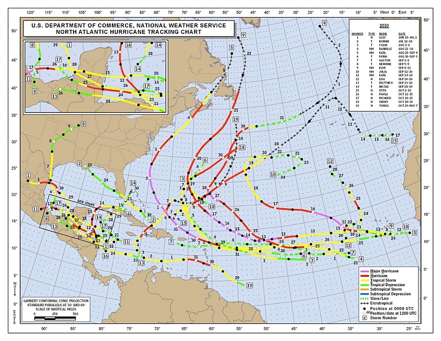
- - Source: NOAA/AOML Hurricane Research Division (click on image for larger size) - -
Weather discussions by Gert & Dave during the 2010 Atlantic Hurricane Season. The homepage with the links to local reports from the islands, latest satellite image, current weather outlook can be found here.
Wednesday, April 20, 2011 15:03PM PDT - First Invest
- It's been a while! But an area of disturbed weather has formed quite a ways north of the islands. It doesn't really look like it will become a tropical storm, or even a tropical depression. And it's only April... although there have been named tropical storms in each calendar month. However it is a reminder that Hurricane Season is coming up, and that I have to make the website ready for the 2011 season... The hurricane names will be the same as six years ago, except for 5 names that were retired (incl. Katrina), see the 2005 Season Recap. -Gert
Friday, April 1, 2011 06:02AM EDT
- Change
-
Good morning!
Happy April Fools Day! Seems like what I have always been saying this winter was true: The Groundhog is overrated!!!! Especially for the snow weary northeast!! I think they should post security around the critter as his forecast for an early spring is anything but accurate! However, in a small sliver of defense, weather is not exactly an exact science or we wouldn't have to study it or work as hard trying to analyze it!
A change a comin' here in the northeastern Caribbean as the mornings of lows btw 69-72 and dry are pretty much over signalling the usual drastic change from winter to virtual summer as spring really isn't a season here. Lows now are a balmy 75-78 and the highs creeping to mid-80's with a return of humidity to yuk levels. After going 3 months without sweating, well, you get the picture!
This also signals a very slow end to our very dry period rain wise. Water rationing was instituted at WAPA (Water and Power Authority) for parts of the island and also those lumbering but necessary water trucks where 5300 gallons can cost up to $525 delivered if you run out!!! Which happens usually when you have visitors or a leak in your cistern! Carnival is fast approaching and the beginning of a historically wet season usually occurs lasting the month of May.
2 months until the start of the 2011 Atlantic hurricane season. Start planning!!
Dave
Sunday, March 13, 2011 22:25PM EDT
- Dry!
-
Good evening,
Happy Sunday night to all! Hope all is well in your worlds! Prayers and thoughts to those in Japan and other areas hit by earthquakes and subsequent tsunamis. Something we should also pay attention to here in the Caribbean as we are not immune to these forces of nature and we tend to forget as we focus more on tropical systems above ground and not enough on what is transpiring under. Here in the northern islands, we have earthquakes virtually everyday, but they are too small or too deep to feel. We are 44 years overdue for the next 100 year quake of 6.5 or better and it's a matter of when and not if.
Dry. Normally, it is dry between Lent and Easter but the aridness started around mid-December and with the exception of a few stray showers (nothing organized), humidity has been low, island foliage is/has been turning brown, fire danger is increasing rapidly, water trucks are out in record numbers, and the very few fresh water ponds we have are drying up. Beautiful blue skies have been abundant since the mostly overcast month of December resulting in delighted tourists and vendors though. Ovcean temperatures remain coolish for locals (79-80) but not so for our visitors. I find it refreshing when I can get the time to get in!!
Dave
Wednesday, February 2, 2011 20:18PM EST
- rain dance
-
Good evening!
This is what I wrote on Facebook earlier today:
Groundhog Day and the furry little bandit who lives high on the hog did not see his shadow so he's predicting an early spring. How could he see his shadow when he was pulled from his burrow "HIBERNATING" with eye's wide shut???? Maybe he can send some rain this way!!
LOL!!! While a top 10, for the historical reporting of ages, lashed the northeast and left Chicago with record setting snow depths for a single 24 hour period and beyond, and even closed DFW for a short while during Super Bowl week, we here in the Eastern Caribbean have been "the beneficiary", as have been many thousands of tourists, of dry, puffy white cumulus clouds, and abundant sunshine with a stray shower almost as scarce as a Saharan desert wadi or oasis! In other words, we need some rain!
After the record setting, flooding rains of November 2010, nirvana from the heavens in the form of rain has been, in the words of the old show "I Dream of Jeannie", Vetch and Vetch Nachi!!!! Slim and none! Feast or famine!!! The islands are turning brown which they haven't done for a few years and with a historically seasonal dry period ahead, Lent to Easter, it could get worse.
Some moisture is working through the middle down islands around Monserrat south and may make a bid this way while a low pressure system to our northeast, while throwing dry air at us currently, may swing around and help us down the road. Time will tell!!!
Dave
Friday, December 31, 2010 11:17AM EST
- New Year
-
Good afternoon everyone!!!
Hope all had a Merry and enjoyable Christmas and I would like to take the time on behalf of Gert and myself to wish all of you a safe and Happy New Year!!!!! May the hurricane winds of 2011 only howl in the open Atlantic!!!!!
Dave
Monday, December 20, 2010 15:27PM EST
- I95
-
Good afternoon!!!
Of course this year wouldn't be complete without a late season (out of season) commotion in the tropical Atlantic, a/k/a I-95!!!!
Haven't studied it much but will tonight after work.
Possible monster on the east coast in the form of rain/snow later this week!!!! Be careful what you wish for!!!
Happy holidays to all!!!!
Dave
Wednesday, December 8, 2010 12:39PM EST
- December
-
Good afternoon!
A quiet December finally arrived after a last month onslaught of named storms which tried to drown parts of the Caribbean including the Virgin Islands and that has been followed by about 2 weeks of dry, crisp, coolish conditions where, on some days, you could see houses on St. Croix and we are 40 NM away!!!!!!! Vieques, Culebra and the west end of Puerto Rico were strikingly clear as well.
40 acres and a mule? How about 40 inches of snow around Buffalo NY and more in some other locations due to lake effect snow!!!! For those of you who were saying it was too cold and dry this last few weeks, would you be willing to trade places? LOL!!!! I didn't think so!!!!
One thing I would like to trade for is a few weeks of NO mosquitoes!!!! Give me 55 degrees and no mosquitoes anytime!!!!
The dry period has ended for St. Croix as they have been the recipients of scatterered showers the last 24 hours or so but the rains have failed to materialize for the most part here in the northern VI and the landscape is starting to show a brown tinge while water trucks are making an all-too familiar slow, crawling, belching diesel appearance on our roads. Just in time for the already crammed roads at holiday time.
Speaking of rains, President Obama issued a disaster declaration last week for the third time this year for the Virgin Islands, this time as a result of flooding rains courtesy of TS Tomas and a slow moving trough, especially affecting St. Croix. Hurricane Earl and TS Otto were the others. This is unprecendented to have this many declarations of disaster in one season.
Happy Holidays!!!
Dave
Saturday, November 13, 2010 09:20AM EST
- Invest 94
-
Good morning!
This weekend report is coming to you live from upstate NY where my wakeup temperature is a balmy and sunny 24 degrees!!! Funny, after two weeks of rain and overcast skies at home in the Virgin Islands, I had to fly over 2500 miles to get some sunshine!!!! Great sleeping weather with crisp skies, calm winds, and frost! Oh, wait, this is a Caribbean website!!!! Back to warmer climes!!!
Invest 94 sure did blossom up overnight and visions of "wrong-way Lenny" danced in my head this morning instead of soon to come Christmas sugarplumbs!!! After checking the steering currents and their forecast for the next few days it appears Central America in the form of Honduras and Nicaragua will be in the path of this slow to develop system. While most conditions are favorable, dry air to the north and rising wind shear after the weekend should keep Invest 94's intensity below hurricane status although we have seen explosive development from some systems this year already.
17 days left in the official 2010 hurricane season. Will we reach Walter? I think we might!!!
Dave
Sunday, November 7, 2010 08:57AM PST - Bye, bye Tomas
- Although there was wide spread flooding in esp. the western part of Haiti, it could have been a lot worse. Esp. the area around Port au Prince, where most refugee camps are seemed to have been spared. Of course, it is still a miserable situation in Haiti, ten months after the earthquake and with the current cholera outbreak. The flooding will unfortunately make conditions worse that help spread cholera...
The Turks & Caicos were spared as well with no realy major damage. Tomas is now over open waters and weakening fast.
I also ended the week-long donations pledge drive. It far exceeded my expectations. Thank you so much everyone who donated. It is good to know that when I need some help, you are ready to jump in! Thanks again! -Gert
Friday, November 5, 2010 08:08AM EDT
- Silver lining
-
Good morning,
As Hurricane Tomas batters an already earthquake and flood ravaged nation of people who have already been subjected to Mother Nature's unwarranted but unstoppable forces, I can see a silver lining in it's passage. World attention will be refocused on Haiti, which has languished after the first few months of international shock and response to the devastating earthquake early this year. Maybe the response will be better coordinated and speedier efforts to recovery and rebuilding will occur. Granted, there are other disasters in the world right now but none so pressing, so human, as this one is and has been for quite a while. Anyone who has lived there all their life under 18 has experienced more natural tragedy than any other human being for such a short span. Our thoughts and prayers go out to all, not just the people but the aid workers and relief specialists who risk their lives in rendering badly needed assistance under teribble conditions.
Usually the rain induced flooding and mudslides would be the biggest threat and probably will be but wind will play a bigger part than usual too as they are not living in wooden and concrete buildings as a norm. Debris is everywhere and as I found out during Hurricane Marilyn first hand, if it flies, it can hurt and/or kill very easily. A tent or flimsy wooden structure is no match for even a Cat 1 hurricane or strong tropical storm.
Mudslides and flooding cannot all be blamed on Mother Nature either as deforestation of virtually the entire nation has made this really a man-made problem. Hopefully, after Tomas passes and life returns to a sense of normalcy, a major reforestation and education program can be instituted. But this also means providing the people with basic necessities so they don't just return to the old ways. Trees aren't grown overnight.
Southern Bahama's and the T&C seem to be in Tomas's direct path after winding through the Windward Passage between Haiti and Eastern Cuba. The DR will also see some heavy rains from the eastern side of this system but they still have forests which should stem the worst flooding and slides.
Tomas still has a couple of days to live as a hurricane and then should rapidly decline to remnant low status. Projected paths by the computer models are a serious late season sphagetti mix making track projection, which is already inexact, even more so. The tail of Tomas, like so many other storm systems, could pack quite a wallop as a final parting gesture.
Possible development in the Caribbean next ten days plus off to the east, a few waves but they are not making any at this time.
Dave
Thursday, November 4, 2010 15:07PM PDT - Rain starting on Haiti
- The good thing is that Tomas so far has not restrengthened into a hurricane and also that the center of Tomas is expected to pass west of Haiti, not over it, but closes to Cuba. The bad thing is that this is a big storm, with most convection (equals rainfall) on the eastern side (Haiti/Dominican Republic side). With over a million of people in Haiti still living under tarps since the earthquake in January and with no real shelter to go to this is a very sad situation. Hopefully the storm won't hang around too long to minimize the amounts of rainfall. Also, it will pass very close to the east of Jamaica, where it also can produce flash flooding and dangerous mudslides.
After Hait it is expected to pass over the southeastern Bahamas and Turks & Caicos. Since wind shear is expected to increase it might strengthen just a bit before it gets there. Again, the biggest problem will be the heavy rainfall. -Gert
Tuesday, November 2, 2010 14:19PM PDT - Tomas a big threat for Haiti
- Although Tomas has weakened a bit more, it is still a big storm as can be seen on the satellite image above. Unfortunately most models still forecast that Tomas will make a sharp turn to the north-east and move towards Haiti. Currently it looks like its path will be a bit more to the west then earlier thought, which is good for Haiti. However, looking at the size of this storm, and all the convection associated with it, it will be a big rain maker for Haiti and the Dominican Republic. Also, the forecast is that it might be a Category 2 hurricane by that time. This will become potentially a huge problem for Haiti where millions of people still live without solid roofs above their head...
Also, a hurricane watch has been issued for Jamaica already, although the center is expected to stay to the east of the island. Tomas also has created some havoc on the ABC islands, esp. Curacao. Also, read more on the aftermath of Tomas for St.Lucia and other islands on the right. -Gert
Monday, November 1, 2010 15:03PM EDT
- the banana terminator!
-
Good afternoon,
Former hurricane Tomas, now a tropical storm, laid waste to the banana crop on St. Vincent as it roared over the island while also causing serious infrastructural damage. Tomas is still heading WSW and, if it stayed on it's current path, would actually threaten Aruba which was lasted visited by Hurricane Felix in 2007. Hurricanes are uncommon for the ABC islands as they lay south of the 'hurricane belt" but are not immune by any means.
Tomas's future is somewhat of a forecast debacle. If the trough is strong enough to pick it up and turn north/northeast, Haiti and the DR would bear the brunt. If it isn't strong enough to pull Tomas's chain, then it will get very, very interesting for Jamaica and the Caymans. The farther south is stays lessens the "right turn Clyde" forecast of the models as well. Warm waters and weakening wind shear down the road set the stage for a possible major hurricane bringing major problems. I don't think the GOM has too much to worry about as wind shear in that area would eat a storm up but then again, it's not impossible either. Everyone should be watching this one.
Dave
Monday, November 1, 2010 07:50AM PDT - Tomas weakening, but watch out Haiti
- What a mess Tomas left on many of the islands, especially on St.Vincent and St.Lucia. St. Vincent and the Grenadines' Prime Minister called it a 'national disaster'. The southern side of St.Lucia was also hard hit. Two main bridges were damaged cutting off parts of the island.
The good news is that Tomas has weakened again to a tropical storm. However, I don't like its path. Saturday I wrote that I was happy that the storm would bypass Haiti, but now it is expected to make a sharp turn in 2-3 days, which aims it directly towards Haiti! Tomas might even regain some strength and redevelop into a hurricane before reaching poor Haiti.
Finally, thank you for the people who have donated so far and the nice e-mail messages I have gotten. Good to hear how many people value this website. -Gert
Sunday, October 31, 2010 12:08PM EDT
- Tomas
-
Good afternoon!
Not having computer access for any length of time more than a couple minutes has inhibited my reporting lately but, here we go!
Hurricane Tomas. Already part of the record books along with Hurricane Shary for late October! Damage has been done in the middle Windward Islands plus unfortunately, loss of life. Tomas is headed slowly through the usually deathly graveyard of storms at the moment and still could intensify to major or Cat 3 status later in the week. What's interesting is the lack of coagulation among the computer models as to when Tomas will stall and where it will go after that.
Currently, gusty winds and a few squalls of rain are affecting the Virgin Islands, BVI's and PR but the afternoon should bring a bit more "weather". We will have to see tonight and tomorrow as Tomas heads further west how steering currents and wind shear will affect our Halloween Night/All Saints Day/D Hamilton Jackson Day/Election Day Tuesday and beyond.
Dave
Saturday, October 30, 2010 12:59PM PDT - Tomas battering the Islands
- Tomas has been upgraded to a hurricane, with sustained winds near 75mph. It is battering many of the southern Windward Islands as can be seen on the above satellite image. I wish it would move a bit faster, esp. since it is quite a big storm. Currently the center is just in between St.Lucia and St.Vincent. Check out the updates on the right coming in from many of the affected islands.
Tomas future looks pretty bad. It is expected to become a major hurricane in the next couple of days. As it looks right now it will travel through the Caribbean Sea, stay south of Haiti (hopefully its outer bands as well, since they don't need rain!), and then aim for Jamaica. This season is not over! -Gert
Friday, October 29, 2010 13:55PM PDT - Tropical Storm Tomas forms as well
- Some late season action... earlier this morning we had Shary and now the Invest I mentioned earlier has been upgraded to Tropical Storm Tomas. This is the 19th of the season! Tropical storm warnings and watches have been issued for many of the Windward Islands, incl. Barbados, Martinique, St.Lucia, Trinidad & Tobago and Grenada (see advisories). -Gert
Friday, October 29, 2010 07:18AM PDT - Shary warning for Bermuda
- One of the three invests we were following was upgraded to Tropical Storm Shary. It is located just about 220 miles south of Bermuda and moving towards the island. A tropical warning has been posted for Bermuda. It will graze by Bermuda later tonight. Shary is not expected to become a hurricane or linger around the island so it shouldn't be a big problem.
On the other hand, Invest 91L could become a big mess for the Windward Islands.As can be seen on the satellite image above it is a large area of disturbed weather and has an 80% chance of developing into a tropical depression. This system will bring a lot of rain and gusty winds to the islands... Check out the reports from the islands that can be found on the right, esp. Grenada and Trinidad and Tobago. -Gert
Sunday, October 24, 2010 09:03AM PDT - Hurricane Richard
- After Richard just passed north of the Bay Islands it is now on its way to make landfall in Belize. Richard has just been upgraded to a hurricane packing 85mph sustained winds. Worse yet, it is expected to intensify a bit more before it reaches land, and might even become a Category 2 storm. Richard will make landfall just south of Belize City later this evening. Hopefully it won't strengthen too much before then. -Gert
Wednesday, October 20, 2010 10:17AM EDT
- Richard?
-
Good morning!
Spaghetti is truly the word this morning as the computer models, who usually do poorly with an unorganized system anyway, are all over the map as far as what direction soon to be TS Richard will take once the shear relaxes a bit and a steering current picks it up.
From north to Florida, west to Nicaragua and the Yucatan, NW into the GOM, about the only direction that's not a solution is due east although it's drifting that way right now with flash flood watches/warnings up for Jamaica again and the Caymans receiving heavy rains.
Until it gets it's act together, the likeliest eventual direction appears to be west with the good potential to meander NW which is not good as those waters were only lightly stirred up by hurricane Paula and it's possible we could have late season hurricane Richard on or after the weekend.
Off to the east, a weak 1010 Low is in the central Atlantic but not much associated shower or thunderstorm activity surrounds it. A pretty vigorous wave for this late in season is exiting the african coast this morning. Something to still watch as it makes it's way west. Saharan dust is scattered around the Atlantic Basin so that will not have much effect but a decent amount of dry air will.
Dave
Friday, October 15, 2010 07:56AM EDT
- quiet
-
Good morning!
Other than TD Paula north of Cuba and heading east, there is not much activity to be had in the Atlantic and Caribbean Basin's. Which is a good thing of course!!!
Paula should dissipate due to strong wind shear and interaction with the mountains of Cuba and curve south and west back into the Caribbean as a remnant low. Could she regenerate or will a new, named system arise in the SW Caribbean? Several of the more reliable models seem to think so as well as the experts and it is an area of favorable formation so Caymans and Jamaica should watch closely as well as points northward.
Off to east it's quiet as well. Good thing as we are still drying out from last week's deluge as we still have areas of run off. The towel brigade is a tired brigade!!!
Dave
Monday, October 11, 2010 13:46PM PDT - Tropical Storm Paula could be a lot of trouble...
- The Invest in the western Caribbean Sea, near the coast of Honduras has just been upgraded to Tropical Storm Paula. It is expected to become a hurricane in the next day or so. However, I don't think the winds are going to be the main problem (again). The 5 day track shows that it will kind of drift around in the same area. This will mean we can expect high accumulations of rain over Nicaragua, Honduras and the Yucatan Peninsula leading to dangerous flash floods and mudslides, esp. in mountainous areas. We have just seen it with Otto and Nicole that rain can cause a lot of havoc on the islands, see e.g. the reports from Jamaica. Let's hope that the models are a bit off and that Paula doesn't hang around for too long in the same place. -Gert
Friday, October 8, 2010 10:17AM EDT
- a peek of sunshine!
-
Good morning!
Extremely poor internet service due to the heavy rains, winds and maybe some incompetence on the part of my Internet Provider left me pretty much powerless to report and I must say a kudo to WAPA, our much maligned Water and Power Authority as it wasn't their fault!!
If you read the latest post from Tortola by da wayward sailor, that post pretty much sums up what has happened here in the US Virgins as well. Public schools are shut down for a third straight day today and all non-essential government employees were told not to report to work either. First, because of what we have experienced so far and second, what might come today and probably will based on satellite loop imagery which shows a strong elongated blobbette to our southwest headed our way!! It looks like the final sting from Otto's tail might be at hand and it looks to be a major owey further exacerbating the situation.
To the west, we have some action with some potential growth possible in the late season breeding grounds of the SW Caribbean. Off to the southeast, we have another tropical wave which has really floated under alot of peoples radar's due to the immediate mess we've experienced. This one packs some major rains as well!
One wave in the central Atlantic which is interacting with some Saharan Dust and one exiting the coast of Africa are next on the conveyor belt which should start winding down as we head in to the last 7 weeks of official hurricane season.
Finally, the sun has peeked out. I always say the rainy overcast days make you appreciate the sunshine when it returns! I definitely need some sunshine and so do my friends who are getting married this Sunday!!
Dave
Thursday, October 7, 2010 10:39AM PDT - Rain, rain, rain...
- The outflow of tropical storm Otto is producing a lot of rainfall in the northern Leeward Islands. The center of Otto is still sitting more or less above the Dominican Republic. There is this long band visible on the satellite image above that doesn't want to move and is responsible for all the rainfall. It looks like it will continue for another day. On St.Maarten the Emergency Operations Center is requesting that all busininesses should let their employees leave by 1PM. Everybody is advised to stay indoors and off the flooded roadways by 3PM until further notice. More reports as they come in from the islands listed on the right... For people on the islands you can use the My Satellite tool to display a satellite loop centered on your island. -Gert
Wednesday, October 6, 2010 13:53PM PDT - Sub-Tropical Storm Otto forms
- We have a new named storm, Otto. The center is currently located above Puerto Rico/Hispaniola and is moving away to the east, so no worries there, at least windwise. However, this system has been dumping a lot of rain on the Islands, see for example the reports from St.Martin, St.John and many others on the right. Luckily so far it seems to spare Haiti where still a lot of people live under tarps..., see for example an article just published on Financial Times website. -Gert
Wednesday, October 6, 2010 00:16AM EDT
- Rain!!
-
Good evening!!!
The Towel Brigade, since being called out of retirement, has been extremely active tonight as heavy rain continues to drown the BVI's, US Virgins, Vieques, Culebra, and parts of Eastern PR. Even now, I cannot see St. John, a mere 4 miles away! I do not have a rain gauge here on the east end of St. Thomas but I will say at least 5-6 inches have fell since this afternoon!!! Not to mention those gusty winds! Those who pooh poohed the rain event just might have crow tomorrow for lunch or dinner (best served cold).
I must say the upper level low to the north which has kept this system off to our east for days has kept many on edge as to, will it, won't it, what is it! For a time it looked like an eagle in full bloom ready to pounce then retreated like Custer should have! I only have a partial roof to catch water where I live and I had drained one cistern to about 2 inches off the bottom. It now has 2 1/2 feet in it with only a 18' x19' roof catchment. Fortunately, the towel brigade has an ally: a water pump to pump from the leaky cistern into the solid one. So the kitchen/living room is actually pretty dry. Bedroom and bathroom, not so but towels, fans and an a/c are collaborating on it. The heavy artillery, a/k/a the 6 gallon wetvac might have to come out tomorrow morning after cruise ship duty. My fiance just returned from Washington State. She hasn't had the "pleasure" of this house enduring a "Caribbean leakage". Let's hope she doesn't want to fly back tomorrow!!!!
Long term, as in 48 hours, this might turn into TS Otto as it drags it's tail to the northwest and ultimately turning northeast. It will probably at least make depression status very soon with more rain and flooding likely the next few days. Don't even think about going into the water for about a week after this is all over either. Contaminents and debris will make the beach waters a cornucopia of amoebas, parameciums, and other bacteria just waiting for your attempt at
stupidity.com. If you want an infection, dive right in!!
Hopefully, this "almost depression" at 30 mph will take an Abien and doze off so I can to!!!
Dave
Saturday, October 2, 2010 22:29PM EDT
- Radar +!
-
Good evening!
A new twist to my previous programming note:
MESSAGE DATE: OCT 02 2010 15:17:00 THE FAA/NWS SAN JUAN WSR-88D (TJUA) RADAR WENT DOWN JUST AFTER 0901 AST OR 02/1301Z. TECHNICIANS WILL NOT GO UP UP UNTIL SUNDAY MORNING. UNTIL THAT TIME THE RADAR WILL BE OUT OF SERVICE. SNELL
If they were troubleshooting earlier, wren't there any technicians on site? I must have missed something here.
Still expecting heavy rains and flooding so nothing has changed since last post with this. However, a lurker has shown up at low latitude around 10.3N, 41W as a nice, neat little blobette with a 1010mb pressure trying to sneak in "under the radar" which obviously isn't a problem at this point! This one will be interesting!
Other than our immediate and imminent tropical wave, 97L behind has flared up and is looking quite ominous. Better idea of what we are looking at in the morning. For now, a moisture laden mess!
Dave
Saturday, October 2, 2010 19:21PM EDT
- radar
-
Good evening!
A quick programming note:
MESSAGE DATE: OCT 02 2010 15:17:00 THE FAA/NWS SAN JUAN WSR-88D (TJUA) DATA FEED TO AT LEAST WFO SAN JUAN IS CURRENTLY DOWN FOR UNKNOWN REASONS. TROUBLESHOOTING IS ONGOING.
One of my pet peeves. Is it only me or just when severe weather is approaching the area (Virgins and PR), the radar is "down for maintenance" or temporarily unavailable!
The worst part is, the alternative radar site, the High Def, in PR is also down. Seems to happen way more than 1/2 the time! Very frustrating.
Either I look at the radar out of Martinique, which I do anyway or I rely on the old standby: look at the sky conditions. Ooops!!! It's dark now!
Thanks Martinique!!
Dave
Saturday, October 2, 2010 09:24AM EDT
- rain soon come!
-
Good morning!
Looks like Otto is still waiting for a date with destiny as he now has minimal chances of making a name for himself in the west central Caribbean but still plenty of moisture abounds to make it miserable for an already rain drenched region. Meanwhile, he does still have a chance to make the name parade to the east of the Northern Antilles as a surface trough and a few waves are about to make mosquito heaven.
As if our heavy rains of yesterday weren't enough, we are in store for a major rain beat down. Don't let today fool you. Yes, the sun is out today, courtesy of a little bit of "dry" air out in front of these waves but that will end tonight unless the whole shebang lifts rapidly to the northwest. I don't think so!
For the Virgin Islands, a flash flood watch has been extended until Sunday night and probably will be extended through part of Monday if the forecast runs true. These systems will slow down and the potential for very heavy rainfall, numerous thunderstorms, but not alot of wind is running high. Get your vitamin D and salt water therapy in today because it won't be available for the next few days at least. (It's why my laundry is on the line already taking advantage of that sunshine!)
After these rains pass and the flooding subsides, it is not safe to immediately go back into the water. Run-off will make all waters, except for way offshore, unsafe for swimming due to contaminants and maybe some debris. Believe me, you do not want to get a staph infection as the price to pay for a few hours in the water. Stay on the beach. I know that's very hard but it's not worth the risk.
The other issue will be the mosquito population which will explode at the end of next week. We already have a dengue fever outbreak and it will obviously get worse before it gets better. Please read up on what you can do help stem the flow of this. Something, once again, you do not want to aquire!
Water pump and wet-vac at attention. Towel brigade, ten hut!
Dave
Saturday, October 2, 2010 00:02AM EDT
- A mess!
-
Good evening!
Quick note.
The Caribbean and Atlantic Basin are a mess!!! Talk about a discombobulated cornucopia of troughs, waves and moisture!!!
We should have Otto relatively soon; either south of Jamaica, or, off to the east where there are several candidates with the one around 40W very interesting. Not to mention some impressive waves still piling off the African coast as if late for the prom (which they are for the September coronation)! They will be taking advantage of still warm SST's and a dire lack of Saharan Dust while wind shear still has been playing a mitigating vital role in the baby step migration.
Either way, with or without development, in the next few days, flooding rains are gonna hit again in the Caribbean. Towel brigade has been called to active duty!
Not the best weekend for the suncasters!
Dave
Thursday, September 30, 2010 10:17AM EDT
- Things that make you go Hmmm!
-
Good morning!
Even I am impressed with the significant amounts of rainfall on portions of the East Coast, Jamaica and Cuba. Nicole, her remnants, and our new Low will live on in many minds much, much longer than Nicole's actual life span. The conditions associated and contributing to this seemingly endless trail of moisture include the Pacific ITCZ and where the collision of troughs near Florida combine to form a "fire hose" aimed up the East Coast, one good thing is overlooked. No other system stands a chance to get into the GOM from the east! The west and southwest is only viable direction at the moment.
Speaking of the east, 97L looks to be around the Northern Antilles by Sunday/Monday as a strong TS according to initial forecasts. Center is located roughly at 13.1N 43.2W moving WNW at 15 mph. A very broad system, it will develop and consolidate slowly as there is some wind shear and dry air ahead. Most of the heavy duty dry air is to the immediate north of 97L so should not be a great inhibiting factor.
As I mentioned before, things are not done yet from the east!!
More later!
Dave
Tuesday, September 28, 2010 21:30PM EDT
- Active!
-
Good evening!
As a 999Mb low, TD#16 is raising havoc everywhere as a ginormous system in the Western Caribbean with our area feeling a few fringe effects. Still, the focus is on the mainland, instead of the Caribbean at the moment as it usually does by the media with a bit of attention paid to the Caymans, Jamaica, Cuba and the Bahamas. I understand as most of that media is US based, but please, give us at least a sound bite!! Severe flooding and tornadic activity is a certainty up the coast and I do understand the attention given there. TS Nicole is still dealing with the midwife! This could be a tough call! Several areas of "disturbed weather" are affecting the region which makes for tough call down the road.
It just irks me after over 10 years of writing for this site, and even before and still (1989) as a resident of the US Virgin Islands, I still fail to comprehend the lack of a little more regional attention. On a beach in Ft. Lauderdale is just not doing it. If you can fly to PR, you can fly to Mexico, Honduras, Belize, Jamaica and the Caymans. Understand the Cuban issue.
Another system is a possibility in a week or so in virtually the same area according to the computer models. Hmmm...October/November conditions. Will we have another "wrong-way" Lenny???
Oh, by the way, while everybodies attention is turned to the west, the east is not over. There are still systems moving in from the African coast. One coming off now is quite potent. One behind it has plenty of energy as well. Wave in Central Atlantic over a thousand miles from the Windwards has, they say, only a 10% chance of development over next 48 hours. Plenty of activity, cyclonic turning in the high and mid levels, still high SST's, a lack of serious wind shear, and almost absent Saharan Dust make this and the two behind it possible lurkers!
We still have 3 weeks of high season with 6 weeks more after that. I mentioned in a previous post October and November these months had high activity potential. It's not over!!! Bottom line: we are into the second half. As we all know, or at least most of us in this region do, lots can happen and have. Pay attention. Remain prepared.
Dave
Tuesday, September 28, 2010 10:39AM EDT
- TD#16
-
Good morning!
TD#16 has arrived!!!!!
Flash flood warnings are up in Jamaica and a mountainside in Mexico has fell possibly killing over a thousand people and burying 300 homes!!!!!! This is from the remnants of Matthew. From our TD, major flooding is in store for the Western Caribbean, Jamaica, Cuba, and the East Coast, especially if it takes a more westerly track. As it is, it's going to be a soaker!!
Nicole is on the horizon!
Dave
Monday, September 27, 2010 16:27PM EDT
- Nicole?
-
Good afternoon!
Next up we have potential Nicole standing at the altar as she awaits her turn down the aisle. Developing slowly, she bodes ill will to the southeast with drenching rains and TS winds. Doubt she has time to reach hurricane status but we've seen these systems blow up and intensify quickly before so all need to pay attention.
Another potential system is close by as well and it will be interesting to see what the interaction will be between the two. Either way, an awful wet this week is here!
Out east, the almost forgotten east, not much going on but never turn your back!!!!!
More late tonight or tomorrow morning.
Dave
Thursday, September 23, 2010 23:09PM EDT
- Hmmm!
-
Good evening!!
Hmmmm! Remnant rains of Karl deliver crushing rains to the Upper Midwest areas of Minnesota, Wisconsin, and the UP of Michigan. Imagine!! Some places have reached 9 inches of rain!!! Corn on the cob going up!!! Talk about a late harvest!!! And who would think! Tropical moisture so far north causing so many problems long after!
Hmmmm! Cape Verde's all of a sudden quiet! TS Lisa, a come se, come sa event! A wanderer! But.......
Hmmmm! TS Matthew! I have been watching his development since last night but have not issued an opinion due to so many possible upcoming scenarios. Remember, weather is an inexact science predicated on local interaction as much as computer models.
What we do know is Honduras, Belize, Guatemala, the Yucatan Peninsula, and even Costa Rica all could potentially experience serious flooding, landslides, and unfortunately, fatalities.
Weak: Continue into the mountains of Honduras and Belize, go west and southwest, and be eventually destroyed. Central America, get ready for a serious flood threat!
Strong: hang out just off the coast of Honduras over the heat rich waters with minimal land interaction, intensify into a hurricane, turn north and terrorize the whole gulf coast, Florida, and even potentially, the Atlantic. This scenario very possible and ugly!
Bottom line: Difficult to forecast with much accuracy long term. All should pay attention Caribbean to GOM regardless. As I mentioned before in a previous post, the Caribbean should start to be monitored more closely. I still don't believe the Cape Verde season is over yet either. Looking for one more to develop from that area.
Dave
Thursday, September 23, 2010 11:04AM PDT - Tropical Depression Fifteen forms in the Caribbean Sea
- The Hurricane Hunters from St.Croix found a well defined circulation in the 'Invest' we have been following for awhile, and therefore has been upgraded to a tropical depression, number 15. It might become Tropical Storm Matthew soon. So far it is expected to skirt just over the northeastern coast of Nicaragua and eastern Honduras and maybe on to Belize. It is not expected to be a hurricane by the time it reaches Nicaragua. The biggest problem will be the large amounts of rains associated with this system... -Gert
Tuesday, September 21, 2010 07:51AM EDT
- A temporary break
-
Good morning!
With Igor transforming into an extratropical but still potent Canadian Maritime system, we still have the ragged remnants of Julia floating around but not for much longer. We also have TS Lisa (my youngest sister is proud!) which will probably go the way of Julia and just be a named storm for names sake. That's actually ok!!!! No land falling systems!
More waves are lined up as is customary this time of year but no new storms are imminent. Time for a break!!!
Dave
Monday, September 20, 2010 09:52AM PDT - Waiting to hear from Bermuda
- Igor is moving away from Bermuda. The first news is no major injuries and no reports of major incidents! But the power is out for a lot of people. Trees down and a lot of debris on the streets naturally. Flooding in St.George's. The Causeway (the bridge that connects St.George's and the airport to the 'main' island) has sustained some damage but could reopen later today. Check out the reports by our special hurricane correspondents on Bermuda to see how they fared. You can also find local news and photos on the following websites: The Royal Gazette, Bernews.com and Bermuda Sun or on news.google.com -Gert
Sunday, September 19, 2010 20:29PM PDT - Igor pummeling Bermuda
- Right now Igor is getting close to its closest point of approach with Bermuda. It is luckily passing about 45 miles to the west of the island. Igor is still a Category 1 hurricane though with sustained winds of near 75mph. A gust of 93 mph has been reported. So in a way this is all good news. Although power is off for most the island I don't expect Igor to be 'devastating'. The houses on Bermuda are very well constructed. The only thing is that tornadoes might bring havoc at some locations. In addition to reports still coming in from our hurricane correspondents (as long as they don't run out of battery power), there are two other newspaper sources I know of giving updates: Bermuda Sun and the Royal Gazette. Let's hope indeed that indeed it won't be too bad, still many more hours to go for them... -Gert
Saturday, September 18, 2010 09:53AM PDT - Igor a bit weaker while closing in on Bermuda
- Not much new with Igor. It is no longer a major hurricane, but still a strong Category 2 storm. The storm is going through an eyewall replacement and it doesn't look like it will regain more strength in the near future. Also looking at the closest point of approach the center of the storm is expected to go directly over Bermuda early Monday morning.
But as said before, and as you can see on the satellite image above, this storm is huge, with hurricane force winds extending outward from the center up to 105 miles, and tropical storm force winds up to 345 miles! Since the storm is now moving about 12 mph, a simple back on the envelope calculation gives that tropical storm force winds could reach Bermuda 29 hours before the center arrives! And looking at the windfield of the +36h forecast (20/0000Z), hurricane winds extend about 90nm to the north and 60nm to the south, so a total of 150nm, which is around 173 miles total. That means that Bermuda might feel hurricane force winds for a total of 173/12 = 14 hours!
The Bermuda weather service has a webcam, and some other nice things on their website. Hopefully that will stay up. Everyone please stay safe on the island. Don't go on the roads during the storm but stay inside. Hopefully our hurricane correspondents on Bermuda can keep us up to date during the storm. -Gert
Friday, September 17, 2010 11:21AM PDT - Hurricanes Karl and Igor
- Not totally unexpected Karl did actually strengthen to a Category 3 storm before making landfall near Veracruz, Mexico. Hopefully it won't be too bad. Someone forwarded me a link to an on-the-ground report from that area, Veracruz Hawkwatch.
Igor, still a large and major hurricane, is on its way to Bermuda. Not much has changed with its path or intensity forecast. Use the tools above to check how close it is and to calculate when Igor is closest. As you probably noted I moved the satellite image above a little bit to the north. Bermuda is the tiny black spot about 1/4 from the top and almost in the center horizontally. So tiny, compared to Igor... The outer bands are actually moving over many of the islands, as far as Barbados, see the satellite imagery webpage.
Tim Adam, living on Grand Cayman forwarded me a document with very practical tips to assess what the storm is doing now. There are a couple of easy things you can do while you are hunkered down during a storm and try to get a clue of what is happening outside. It explains how you can use a barometer to see if the storm is getting closer to you or finally leaving. Using a compass or your arms you can find out where the center of the storm is relative to you. Also it has some other practical info on what the winds are going to do, etc. I would advise people on Bermuda (and other people on the islands) to print it out and use it during the storm. It will give you some distraction and also will make you feel better since you can find out what is kind of going on outside... Click on this link to download the pdf-file. Credit of this nice guide goes to Tim Adam, his contact info is in the file if you want to send him a nice thank you note. -Gert
Thursday, September 16, 2010 21:40PM EDT
- Hmmm!
-
Good evening!
The existing systems:
Karl: Cat 2 already based upon flight recon. Not much time to intensify to Cat 3 but possible before landfall for the second time in Mexico. If it had followed the earlier forecast track, it would have been a Cat 3 as it's time over those beckoning hot waters of the Bay of Capeche would have been too much.
Igor the Immense: Not much else to be said. Probable re-intensification once it gets rid of some pesky dry air to it's west but not by much. Bermuda is in for a day plus of very rough weather up to and possibly including a direct hit. Bermuda is an island though which has strict building code standards and unlike many Caribbean islands, enforces them, so anything other than a direct hit should be weathered (no pun). Not saying there won't be damage but not like other islands in the Caribbean.
Julia: Had her 15 minutes of fame. Recurve.
10N, 40W: Next area to pay attention too. Maybe south into the Central Caribbean. Maybe a curve to the Northern Antilles. Hmmm.
African coast: Very active with next round of pretenders waiting to take their shot! 10-14 days.
Bottom line: Over 40% of season still remains. Fortunately, with the amount of activity and strength of storms, for the most part, it has been lacking in severe damage, injuries, and fatalities. This "lucky" scenario will not last long I believe. They say beware the Ides of March. If there are Ides in October and November, I'll beware them this season. Previous storms have taken immense amounts of energy from the sea surface but heat goes well below!
Dave
Thursday, September 16, 2010 09:41AM PDT - Three hurricanes!
- Karl has just been upgraded to a hurricane, so we now have three hurricanes. This is pretty rare, it has only occured 8 other times since the 1850s. In 1998, the year of Georges and Mitch, there were even four hurricane simultaneously!
First Igor, which is still a big Category 4 storm heading straight for Bermuda. Its Closest Point of Approach is only 45 miles, early Monday morning. However, conditions will deterioate well before that, see below. Igor will see a bit more wind shear in its path, and is expected to weaken a bit, maybe to Category 3 strength, so still a major hurricane. Jeff Masters of Weather Underground posted the following regarding Igor's impacts on the Rock on his Wunder Blog: "By Saturday night, Igor's tropical storm force winds are expected to extend outwards 310 miles from the center. Igor will be moving at about 11 - 13 mph during the final 24 hours of its approach to Bermuda, so that island can expect a period of 39+ mph tropical storm force winds to begin near midnight Saturday night--a full 24 hours before the core of Igor arrives. Igor will speed up to about 15 mph as it passes Bermuda near midnight Sunday night. Hurricane force winds will probably extend out about 60 miles from the center then, and the island can expect to be pounded by hurricane force winds for up to 6 - 8 hours if the core of the hurricane tracks over the island. In all, Bermuda is likely to suffer a remarkably long 36-hour period of tropical storm force winds, with the potential for many hours of hurricane force winds. Long-duration poundings like this are very stressful for buildings, and there is the potential for significant damage on Bermuda."
Hurricane Karl is closing in on Mexico again, after is crossed the Yucatan Peninsula. It is expected to strengthen a bit more before it makes landfall, near Poza Rica. Since we still have a hard time forecasting intensity, it is even possible that it will become a Category 3.
The last hurricane to talk about, Julia should stay nicely away from any landmass. Stay safe everybody! -Gert
|
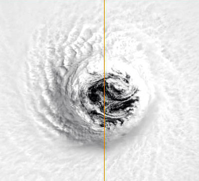
| Igor's eye (Sep.13, 2010, MODIS/Aqua) |
Tuesday, September 14, 2010 17:14PM EDT
- 3 named, several lurking!
-
Good afternoon!!!
Slow moving, almost putting us to sleep, Igor the Iconic, continues to churn away as a Cat 4 storm with some potential to still reach the creme del a creme status of Category 5 while Julia the Judicious is still relegated to Cat 1 status NW of the Cape Verde Islands and will be very lucky to make Cat 2 before dying a slow quiet death. Igor, on the other hand, has a few more days ahead of it as a major hurricane and is posturing Bermuda while flirting ever so slightly with a CONUS or Canadian swipe. Fortunately, short range, our islands will be spared the wrath of Igor as he plods at 7 mph to the WNW, eventually passing around 500 miles to the NE.
The mess that formed in the SE Caribbean last Thursday has finally decided, hey, I want a piece of the action, and has taken advantage of almost hot SST's and low wind shear in the Western Caribbean to be named TS Karl. Doing what the former pretender known as Gaston couldn't do, Karl organized before reaching the Yucatan raising TS warnings all along the coast. The possibility exists if Karl survives his peninsula encounter, he will rapidly re-energize in the Bay of Campeche before striking a second time on a Mexican coastline causing major flooding in the mountainous region.
Other areas of interest is the obvious African conveyor belt, a wave just exiting the African coastline, and a disturbance almost hidden among the giants near 8N, 36W. A true lurker indeed.
The GOM looks safe for now which, with all this activity, might be looking at the quiet before the storm itself with October and November just around the corner. Gulf Coast, don't put those blinders on just yet!
Dave
Tuesday, September 14, 2010 13:53PM PDT - Igor is turning
- At long last, but as expected, Igor is turning towards the north! It is now at 18.8N, above the 18°N latitude line, and with the northern Windward islands like St.Maarten and Anguilla that is where I would like it. But it is still a major hurricane so we will still keep an eye on it. And Bermuda... despite what the National Hurricane Center is saying that you shouldn't focus too much on the 5-day point in the track advisory, I would start stocking up and getting those hurricane shutters ready.
There is also a new storm, Karl, in the western Caribbean, closing in on the Mexican Yucatan and Belize for which tropical storm warnings have been posted. This will be mostly a rain event. -Gert
Monday, September 13, 2010 22:53PM EDT
- To turn or not to turn!
-
Good evening!
Hurricane Igor, undergoing an eye wall replacement, is still on a 270 degree westward track at 9 knots. Still forecast to turn NW within 36 hours. Can anybody say "awkward"?
We'll see in 6-12 hours.
Dave
Monday, September 13, 2010 17:02PM EDT
- Close or not?
-
Good afternoon!
Hurricane Igor, still a Cat 4 monster 1200 miles across from stem to stern, is still heading due west but only at 9 knots. And I thought Hurricane Luis was big in 1995! This track is expected to continue for a short while, 12 hours or so, and then he is forecast to start his turn to the WNW. Igor has been doing what the earlier storms have been doing: moving farther west than the computer models have said. So, just how far west will Igor go? Hard to tell although if you totally believe computer guidance, it won't be too far before the turn happens. It has moved north by .2 degrees in the last 6 hours which is good news but as Gert says, it needs to get over that 18 degree latitude hump before we start breathing a sigh of relief. Time will tell. In the meantime, anxiety has started to build among the northern islands populace and for good reason. BTW, if Igor does turn to the WNW, there is no guarantee the CONUS is safe.
TS Julia has picked up a bit but for now a threat only to shipping interests.
92L seems to imitate Gaston: Wildly fluctuate from convection on an organizational scale to a disorganized blob. Still, could be a TS by then end of it's lifetime. Meanwhile, heavy rains flood Jamaica, Haiti, Cuba and The Caymans.
Dave
Monday, September 13, 2010 09:55AM PDT - Turn, Igor, Turn!
- The satellite picture above looks very scary, an almost Category 5 hurricane closing in on the islands. But it should turn north, that's at least what the models are saying, however, so far no go. Although when I overlay the satellite image with the Closest Point of Approach tool it seems that the eye is a bit north of the forecasted track. So it looks like it is starting to turn north. Hope that is the case. I think Igor is a bit different then Earl, which came much closer then first thought. The models were changing Earl's track southward all the time, with Igor on the other hand they have been pretty consistent, so I guess/assume they are more sure of themselves. Regardless, we can not ignore Igor until it is really north of us. Also, Bermuda... here is another one closing in on you! -Gert
Sunday, September 12, 2010 11:46AM EDT
- updates
-
Good morning all!
Quick update as Internet on the fritz!!!!
Igor will soon become just as evil as his historical name as he is forecast to become a Cat 4 and may even reach Cat 5 status later next week! Still, with all that huff and puff, he is not forecast to be a threat to any land masses. However, we have already seen the lack of accuracy in recurving storms from the computer models and if he stays to the south of the guidance envelope, contact with the islands and the CONUS are very possible.
TD#!2, while looking extremely ominous coming off the African coast, isn't forecast to make it very far before heading NW. Something to watch for now except for the northern Cape Verde Islands which is experiencing TS conditions.
92L, south of the DR, has blossomed back up after an overnight crash due to dry air infiltration. Tracksd here are difficult too although a westerly component is forecast with ultimate impact the Yucatan and Northern Mexico. Having moved north as I said in a previous post with a westerly component, only St. Croix received some decent amounts of rain along with PR. The northern islands were left bereft with a scattered shower or two only. It just needed to move a bit more north. Oh well, towel brigade on stand down.
Breezy here with clothes on line drying in less than 40 minutes!!!!!
Dave
Thursday, September 9, 2010 07:49AM EDT
- surprise!
-
Good morning!!!
While TS Igor (Isabel I like the EEgore pronunciation and not the "Hooked on Phonics" pronunciation as "I"gor) continues a very slow crawl towards the west south of the Cape Verde Islands, and the remnants of Hermine continue to dominate TWC, an insidious interloper might be trying to sneak up on us from the southeast!
A weak area of low pressure to the east of Trinidad and Tobago looks to have blown up quite a bit between last night and this morning and does have some potential for development. Potential track would be to the north towards the Virgin Islands and PR with possible heavy rainfall.
Again, possibility exists but not much attention is being paid yet. Something to monitor, especially with tomorrow the climatological peak of hurricane season.
Dave
Tuesday, September 7, 2010 21:35PM EDT
- It is what it is!
-
Good evening!
Surprise! A usurper decided to claim the name Hermine during the holiday weekend in the Bay of Campeche as opposed to our lined up, but not ready to produce, systems in the far Eastern Atlantic. Strengthening rapidly, TS Hermine needed only a few more hours to reach hurricane strength but instead, plowed into Northern Mexico and Southeastern Texas as a strong, 65 mph tropical storm. Since it was gaining strength as it hit the coast, it has remained a TS for quite a while over land. Just a bit a go though, Hermine was relegated to TD status but will cause problems for days with flooding and tornadoes as it makes it's way through the lower midwest.
Gaston. The name has been relegated to remnant but the system still lives on and still has potential down the road for regeneration. Currently south of Puerto Rico, the remnants have brought rains and some gusty winds to the British and US Virgin Islands and PR but nothing like was forecast previously. Remember, weather is an inexact science. All the conditions for development could be 100% favorable for a system to develop. Unforeseen or non-understood conditions can and do put a kink at times in that 100%. We are all still learning because of this! I still believe the remnants will redevelop down the road. Lingering dry air stalled that redevelopment to our east which is the good news. ( I still would like a bit more rain though!) TWC forecast says 80% chance of thunderstorms and rain through Wednesday night plus windy conditions. I don't think so. For 30 minutes all day maybe.
Off the African coast, one system to the north and one to the south of the Cape Verde Islands creating a "Verde sandwich!" are both impressive in their own right but the northern one should die out soon while the southern one has a long time to develop into Igor. "I" storms recently have had bad intentions with infamous names like Ivan and Ike. Hmmmm.....
On the African continent itself, the escalator, which started slow, has been fast forwarded with at least 4 more waves locked and loaded to shoot off the coast and make their own name a legacy in hurricane lore.
The next 3-4 weeks will be active, interesting, and potentially destructive.
Dave
Sunday, September 5, 2010 19:59PM EDT
- reborn
-
Good evening!
The remnants of Gaston continue to ferment east of the Northern Antilles, alternately looking lame like our cell service was during Earl, to almost TS status and worthy of regaining some short-lived, past glory. Conditions continue to look favorable for re-generation and, by the looks of satellite presentations, wouldn't be surprised if the remnants were at least resurrected to TD status at 11:00 pm tonight. Steve in Anguilla, please see my previous posts as I did mention Gaston's probable revival all along. Others just wouldn't go out on a limb.I must concur having something so close and not many seeming to have a clue is disconcerting but this is also where experience and the human touch outweigh computer models and the NHC.
Off the African continent, the next contestant is probable Hermine. Igor, my second favorite name of the 2010 hurricane season, isn't far behind. (My first is Lisa, one of my sisters!) Too early to talk about tracks and intensity though. Behind that, another impressive wave. Looks like the rest of September will not be boring or quiet!
Dave
Friday, September 3, 2010 19:54PM EDT
- Chocahontas!
-
Good evening!
Looks like the former TS Gaston the Great, who turned into a chocahontas due to the inhalation of copious amounts of dry air and Saharan dust (I'd probably choke too!), is about to enter an area untouched by the three previous named entities, namely Danielle, Earl, and Fiona. That being said, moist air along with SST's untouched by the earlier storms, and a final escape of that dreaded dry air and dust should allow regeneration to occur. If he does, depending on forward speed, Gaston will be in our neck of the woods between Wednesday and Friday. What as, time will tell!!!! Have fun this holiday weekend but a wary eye should not be closed.
99L still might alight on the stage as a named storm but according to guidance will die a quick death by turning to the northwest.
Igor is not far behind!
Dave
Friday, September 3, 2010 08:41AM EDT
- The Phoenix!
-
Good morning!
Who's up next in the "What have you done for me lately?" category? The remnants of Danielle are headed for Europe, Earl is headed for Mass. and Newfoundland while Fiona is going to give Bermuda another close shave. Next up "was" Gaston the Great but now he ain't! Dry air, saharan dust, and cooler SST's brought about by the 3 previous systems has taken the steam out of Gaston, who at one time, was forecast to become a Cat 2 or 3 as it followed a slightly more southerly track to the Caribbean. Instead, the next car of the 2010 hurricane train has been derailed. However, like Isabel in STX said, this car needs to be still monitored as it gets closer to the islands where warmer SST's and moist air left over await. The Phoenix may yet rise again!
The other option: The remnants of the system formerly know as Gaston could just plow forward as a tropical wave into the Windwards. Best case scenario for us. However, if that did happen, a monster could form in the Central Caribbean and threaten our neighbors to the west and GOM! Worst case scenario there.
Just off the coast behind once contender, now pretender Gaston is a lurker with no name as of yet. Behind that, still on the African continent, is several more cars lined up with no caboose in sight!
Dave
Thursday, September 2, 2010 13:54PM PDT - Gaston a remnant low!
- Some good news finally. It seems that Gaston is falling apart. So no 1,2,3, or E,F,G punch for the northern Leeward Islands. Hopefully Gaston doesn't regenerate so we will still monitor it of course. But it is quite a relief I might say. Good luck everyone on the East Coast with Earl. We went through it already when it wasn't even as strong, and it still left quite a mark! -Gert
Wednesday, September 1, 2010 23:30PM EDT
- Interestingly Dangerous
-
Good evening!
For East Coast indications, Hurricane Earl continues to mystify the experts by intensifying in the face of dry air intervention which should tell them something they should already know: Weather is not an exact science and the force we label as Mother Nature has her own intentions in mind! Unfortunately, this scenario plays out again and again with too much reliance on technology and not enough attention to reality. Fortunately, anything hurricane related has improved many fold over the last 10 years but still, conjecture is what it is, conjecture. A mere 50 miles can make all the difference in the world like it did here in the Virgin Islands. Vegetation trashed to totally infrastructure trashed. Sounds like a big distance but it really isn't! And they say big things come in small packages!!!
With Earl headed up the East Coast and grabbing all of the media attention, TS Fiona is not the Fearless anymore but the Fizzeler! Still, until she vacates the area, heavy rains and gusty winds are possible with a potential threat to Bermuda later down the road but I wouldn't actually call her a threat even then. She looks lamer than TS Gaston!
Speaking of, TS Gaston is now the Caribbean's area of interest as well as he should be. If the ridge strengthens as it is forecast to, Gaston will be in the laps of the Northern Antilles between Tuesday night and Thursday as a strong Cat 2 or 3. He is getting ready to put his tux on and join the dance as a serious contender. If you thought Earl was easy and Fiona a joke, like I have heard many say, you ought to put your reality caps on. The potential here for this one is bad.
Speaking of potential: soon to be named Hermine has exited the African Coast and is ready to put on her party dress!
Chat tomorrow!!!
Dave
Wednesday, September 1, 2010 20:18PM EDT
- Busy!
-
Good evening!
Just a quick note for now with more detail after 11 pm.
TS Fiona the Fearless has, for my purposes, degenerated into TS Fiona the Fragmented! This is the worse looking 60mph sustained wind, tropical storm I have ever seen. I've seen way better looking TD's!!!! However, since it is still officially classified this way, it is what it is. Extensive cloud cover and brief periods of activity is all that is left of Fiona here around the islands. Brief periods meaning isolated showers and thunderstorms.
Hurricane Earl is still the talk of the East Coast and if he speeds up, time will be of the essence which you will not have! Evacuation routes, mostly 2 lane highways, will become clogged and troublesome so if your close to the coast, you should think about leaving now. You could possibly get caught in the storm sitting in traffic! I-95 is not a coastal highway!
TS Gaston, a mere knight in waiting at the moment, has set an ominous course our way. Too early to tell his true intentions but early computer models have the eye of a Cat 2 hurricane, 33 miles from St. Thomas next Wednesday. Again, these long scale forecasts sometimes have huge error amounts of 200-400 hundred miles but it's not wise to count on error!!! Earl was a wakeup call and rightly so with so many naysayers and procrastinators. If you ween't prepared for whatever reason, do so.
Off to the African coast, potential Hermine, no, probable Hermine, has landed in the Atlantic. Igor is just waiting his turn.
More after 11!
Dave
Wednesday, September 1, 2010 11:12AM EDT
- Bullet #3
-
Good morning!
While Earl continues to make many along the East Coast shake in their collective pants, TS Fiona picked up some muscle earlier this morning but now looks pretty ragged for a 60 mph TS. However, since she decided drop her skirt back down (guess she figured Earl wasn't worth dying for!), Fiona now actually has a short opportunity to reach hurricane status. The good news is she has started her NW movement and therefore will not pose a serious threat to our islands although in some areas, even a little mischief from Fiona will exacerbate problems from Earl like St. Maarten, Barbuda and Anegda. Bullet #2 dodged.
But, will be dodge Bullet #3? TD#9 has just been classified and is moving west at 15 mph. Currently 1862 miles ESE of Anguilla, if it maintained this speed, it would reach the Northern Antilles on this coming Monday. But that day is a long way off in terms of forecasting tropical systems. Not expected to strengthen rapidly, this poses a bigger threat to the islands in the form of Gaston.
More later!!
Tuesday, August 31, 2010 18:59PM EDT
- Fiona and the future
-
Good evening!
Yes, I have power finally. My generator performed admirably after being called from a long slumber but you don't know what your missing until it's gone. Many take power for granted. Morning talk shows had some people, as they have after every storm, asking when they are gonna get "current'. I think they need to take a class in "unselfishness" first! Most of St. John is still out along with large parts of St. Thomas. Not sure about St. Croix.
Earl the Eyeopener is lurking north of Puerto Rico and grazing the T & C Islands before he begins to menace the East Coast of the US. Still a Cat 4, Earl isn't looking so fine at the moment due to wind shear on the western side but don't let that ragged appearance fool you! This is a system to respect.
Ever since he was hatched, Earl has forever been on the left side of the guidance envelope; in other words, west of where he was supposed to be. This non-endearing part of his attitude is what is causing much concern along the coast all the way up through New England and Canada. What if Earl became that storm on: "It Could happen Tomorrow"? A hurricane plowing into New York harbor and up the Hudson? never say never. It is only a matter of when.
Fiona the Fearless looks like she is going to die a slow death due exactly to her fearlessness as she is rushing to the destruction that is Earl's tail. Earl is plodding a modest 15 knots while Fiona is foaming at his heels at 24 knots. I'd say a union is imminent over next few days with the male eating his counterpart instead of the female as in black widows and praying mantis's. Even so, more rains and breezier winds will be in store for the Northern Leewards.
98L is watching what is happening on the stage ahead and gauging his chances. Once again, the longer it takes to organize, the the worse it could be for the Caribbean. And it looks like it will be a slow organizer with dust, dry air, and a bit cooler waters to form over. 4 more waves are lined up and getting ready for their maiden appearance in the Atlantic. Where are the naysayers now??
Dave
Tuesday, August 31, 2010 11:50AM EDT
- Over
-
Good morning!
Hurricane Earl made a much more dramatic arrival last evening than many thought. More naysayers than believers. Power is still out for most of island except key feeder for police and hospital that I am aware of. Some lost power early yesterday. I was lucky until 7 pm last night when he really started to howl. Numerous trees are down, big ones too, branches and leaf debris everywhere. Many transformers have blown up which will surely slow the pace of power restoration. Obviously, cable is out as well. That's been out since early yesterday.
Curfew is still in effect officially until noon but you'd never know it by amount of traffic on the roads. Some stores have reopened and gas stations as well. They are plenty packed which means alot of people didn't prepare ahead of time. Marine wise, seas rough and at least a dozen boats have run aground or are running loose from their moorings. No fatalities or serious injuries to report as of this moment which is always the good news.
TS Fiona is hiking up her skirt and chasing Earl for all he is worth. We expect her in the next 48 hours and then a break for Labor Day. Meanwhile, more waves are lined up and ready to have their chance at this years crown. This storm was closer than "most" expected so it was good practice but it really shouldn't come down to having a trial run. We should be prepared regardless.
More later if my AT&T internet is working finally on the East End of the island or my iPhone (another AT&T product) is working. They were both on Digicell/Lime all night and this morning and did not work well at all. hate to see the roaming charges involved there!! Earl was a brushby. If you can't work during a brushby, you'll never work during a direct hit even though the towers are rated at 220 mph!
Good luck all!!!!! The US Virgins were lucky this time. Anegada, and other islands were not. Prayers and thoughts to them.
Dave
Monday, August 30, 2010 14:17PM PDT - Tropical Storm Fiona forms behind Hurricane Earl
- Before everyone starts panicking on the islands..., yes, there is a new tropical storm, and yes, it is taking a similar path to Earl, and yes, it is coming fast. However it is not expected to be as big as Earl just became, but just a tropical storm with 50mph winds or so. Also, it should go a bit more to the north, ie., away from the islands. So no need to panic! Use the tools above to see how close it can get to you.
Earl on the other hand has become a big one. Glad that this didn't happen just 24 hours earlier. I have been collecting some impressive satellite images over here. -Gert
Monday, August 30, 2010 11:48AM EDT
- Update
-
Good afternoon!!
Here is St. Thomas, cable is out, power out in some areas, trees are down, my Internet is down and the worst part of the storm won't be here until 6 pm tonight!! For reports from other islands, please see them on the right of your screen. No official curfew yet but expect one around 2-3 pm. Eye of Earl about 90 miles northeast of St Thomas as of 11am advisory. Rain bands have been on and off but more frequent. Weird as it's almost noon but looks like dusk.
Dave
Sent from my iPhone
Monday, August 30, 2010 08:33AM PDT - Earl a Major Hurricane
- Earl is now moving away from Anguilla and St.Martin. The eye of the storm came as close as about 25 miles to Anguilla and 35 miles to St.Martin, it seems like it made a little dip south. But lucky for them it was still 'just' a Category 2 storm. Just after it passed the islands it was upgraded to Category 3, or major hurricane, packing 120mph winds (sustained!). Since it goes a bit more north now, it won't get as close to the US and British Virgin Islands as it did to Anguilla and St.Martin. First reports indicate no major damage on the islands. See updates on the right. I have also been collecting some impressive satellite images of Earl from the last couple of hours.
Behind Earl is another system. It is still just an 'invest', and not even a tropical depression or tropical storm (Fiona) yet. However, it is following the same track as Earl, maybe a bit to the north. Luckily it is not expected to become a hurricane before it reaches the islands in the next couple of days.
-Gert
Monday, August 30, 2010 07:06AM EDT
- Earl's tail is here!!!
-
Good morning!
Hurricane Earl has intensified drmatically from last night and is now a strong Cat 2. Already pounding Antigua, Barbuda, St. Maarten/St. Martin, Anguilla, St. Barts and Guadeloupe with forecast stengthening to Cat 4 status within the next 72 hours! Earl has made his appearance here in the Virgin Islands, both British and US, with gusty winds and squally rain showers. Winds are NNW at 35 with gusts to 48 currently along with heavy rain. A hurricane warning is in effect as well as tropical storm warning and a flash flood warning starts from 2 pm this afternoon until tomorrow morning. Power had fluctuated this morning but remains on at this time. If the power does go out, WAPA will not effect repairs until the storm has passed and if sustained winds reach 64 mph, they will shut down the power grid to protect all equipment. Cable has been on and off all morning as well.
Hey, Stormcarib was just mentioned on the Weather Channel when they were talking about a cam shot of Simpson Bay in St. Maarten!!!!!! They also did a piece on PR but as usual, do not give the Virgin Islands much mention.
More later. I have to go to work as one of our clients (a business owner) decided he wanted his hurricane shutters this morning. Nothing like waiting till the last minute and putting others at risk. Oh well, I know other islands have some of these same clones!
It will get worse here as day goes on as the tail of Earl is striking first here in the territory. And behind Earl, just a few days away, is possible Fiona!!!!!
Dave
Sunday, August 29, 2010 20:01PM PDT - Earl starting to batter the Islands
- Here he comes... Earl is now a Category 2 hurricane, packing 100 mph winds. Some strengthening is still expected, and might become a major hurricane tomorrow. The center of the storm is now only 50 miles from Barbuda and about 130 miles from St.Martin, it just didn't want to turn north soon enough. But as we all (should) know, a hurricane is not a point, just take a look at the above satellite image. Hurricane conditions are expected starting early tomorrow morning in the northern Leeward Islands, especially for the islands of Anguilla, St.Martin and St.Barths. On the right you can find the links to reports by the special hurricane correspondents on the islands. Above use the tools to see how close the storm is or how close it can get (Closest Point of Approach). Stay safe everybody! -Gert
Sunday, August 29, 2010 12:35PM EDT
- Who else??
-
Good afternoon!
All of a sudden, the islands have transformed into beehives of activity! Stores are packed with procrastinating shoppers, gas stations are way busier, and even my co-workers have a sense of urgency!!!! Here is the US Virgin Islands, especially St. John, St. Thomas and Water Island, people are actually starting to take Hurricane Earl seriously. While on my way into work, I did not see anyone boarding up their homes but some businesses on the waterfront have shutters up already which is a good thing. My day position here at the warehouse, all is boarded up already and shortly will be shutting down all electronics. Then, it's off to home to clear the deck and get the towel brigade ready. Generator has been ready a long time and my curfew pass is in my pocket! The port is under Condition X-Ray for you mariners and is anticipated to be under Condition Yankee by 11 pm tonight.
Hurricane Earl is supposed to still turn to the WNW before he strikes the Virgin Islands (Includes BVI's as well) but he has not lived up to his forecast track yet since Tuesday when I mentioned he probably wouldn't so why would I have faith in that forecast now? If he does turn even slightly, the potential damage would be lessened immensely due to being struck by the much less powerful southern quadrants. Extrapolated out right now, the center would be 90 miles to the NE at 10 pm tomorow. With TS force winds extending 160 to the north and northeast, the southern side is only extending half that so if he stays on forecast track, we would be subject to TS force gusts and heavy rain bands only. But Earl is forecasted to become Cat 2 by that time as well. Unfortunately, I don't believe we will escape that easy.
The airport has already cancelled Monday morning flights, (my girlfriend was supposed to fly out tomorrow 8:20 am), and many vessels have departed for safe harbor. One oddity: There is a large multi-million dollar yacht still sitting at the Yacht Haven Grande dock. What are they thinking????? Either they have severe engine problems or the captain thinks the vesel and themselves are bulletproof! Not good!!!
More later!
Dave
Saturday, August 28, 2010 08:21AM EDT
- Threatening Earl
-
Good morning!
With Danielle getting ready to meet her demise in the North Atlantic after giving Bermuda a mid-season scare and Invest 97L encountering rough times with Saharan Dust and slightly cooler SST's, thereby delaying her ballroom entrance on the Atlantic stage as Fiona, Earl is winding up and taking aim at the Northern Antilles, especially since his dip and repositioning to the SW overnight. Currently, tropical storm watches have been posted for the islands of: Saint Martin and Saint Barthelemy, Antigua, Barbuda, Montserrat, St. Kitts, Nevis, Anguilla, St. Maarten, Saba, and St. Eustatius. TS force winds up to 60 mph extend up to 85 mph from the center but the wind field shows that distance to the west and north so any movement northwest/north will lessen the impacts of TS force winds on our islands as the distance of extension from center is much shorter. However, intensification is expected to hurricane status by tomorrow and the wind field could expand. Closest approach to all islands at the moment is far enough away to keep the TS force winds at bay but that will change with time, especially if Earl does not turn soon. I mentioned back on Tuesday Earl should not be discounted by the islands as it was too far out for confidence in the computer models track. Sometimes, even though we all like to be right, I wish I was wrong. We all could use some good rains but not a hurricane! Earl is not here yet so there is still time for turning but he is pushing the envelope!!!
The COPT (Captain of the Port, sector San Juan) USCG has issued some preliminary instructions and advisements as that sector controls all US Virgin Islands ports. I expect updates later today affecting all mariners including pleasure yachts, cargo vessels, and cruise ships, especially if Earl remains determined to head west and intensifies.
Down the road, Earl has the possibility of reaching 70W before turning. Not good news for the mainland, Bahama's, Bermuda and other points west. Again, possibility.
Invest 97L could be our next headache in the Northern Antilles and once again, the longer it takes for it to become organized, the better chance it has of affecting any of our Caribbean Islands and eventually the CONUS. In addition, I count 4 more waves lined up across the African continent getting ready to take their turn at bat.
Dave
Saturday, August 28, 2010 03:53AM EDT
- late
-
Sorry, it's late! For clarification, tomorrow means today.
Dave
Saturday, August 28, 2010 03:50AM EDT
- Ever westward Earl
-
Good morning!
Just a quick note before my pillow collides with my head:
All in Northern Islands need to monitor Earl closely. It's jog to the SW via satellite continues to not make a believer out of me it will turn in time. Still, it has plenty of open water to traverse but I won't be surprised if more watches are posted by 11 am tomorrow if not by 5am.
More later in am!
If your not ready, you'd better change your planning tomorrow as, if it isn't Earl paying an unwelcome and not entirely unexpected visit, soon-to-be named Fiona just might.
Dave
Friday, August 27, 2010 14:02PM PDT - Tropical Storm Watches for Bermuda, St.Martin and St.Barths
- The National Hurricane Center has issued a tropical storm watch for Bermuda:
ALTHOUGH THE CENTER OF DANIELLE IS EXPECTED TO PASS WELL TO THE EAST
OF BERMUDA...THE LARGE AND EXPANDING WIND FIELD ON THE WEST SIDE OF
THE HURRICANE COULD BRING TROPICAL-STORM-FORCE WINDS CLOSE TO
BERMUDA ON SATURDAY. FOR THIS REASON...A TROPICAL STORM WATCH HAS
BEEN ISSUED FOR THAT ISLAND.
As for Earl, it is racing towards the islands at 20mph. The current forecast takes the center of Earl again a bit closer to the northern Leeward Islands and a tropical storm watch has been issued for (French) St.Martin and St.Barths and possibly more to follow. A tropical storm watch means that tropical storm force winds are possible within 72 hours. Still, this is not expected to become a major hurricane, but better be prepared. This could be a nice practice run. -Gert
Friday, August 27, 2010 11:34AM EDT
- Earl and Forecasting
-
Good morning!
Danielle is a force to be reckoned as a Cat 4 hurricane but fortunately, the CONUS (continental United states) and Canada appear to be safe from her fury as long as the forecasted track holds up. Bermuda, on the other hand, might get a more personal and up close perspective if she doesn't turn more northward soon.
TS Earl also appears to be on track to becoming a major hurricane down the forecast road but unlike Danielle, he might pay an unwelcome visit to the northern Leeward Islands if he doesn't start to turn towards the WNW or NW by Sunday night as a borderline Cat 2 or stronger hurricane. Current forecast track is pretty much a beeline west for the next 48 hours then the turn should start but as we all know better, weather is an in-exact science and as such, we are relying maybe too much on computers and not enough on raw skill and experience.
Bottom line: Earl needs to be paid attention to.
Invest 97 and the subsequent troops falling off the African continent will most likely not curve or recurve as much as the vanguard of the Cape Verde season has which puts not only the CONUS in danger but the Caribbean as well. The hurricanes are up to bat and it looks like the pitching duo of wind shear and dry air is running out of steam. I don't see a quick 3 outs!
Dave
Friday, August 27, 2010 07:33AM PDT - Danielle, Earl and soon Fiona
- Good morning,
Just in time back from my travels since things are heating up! We soon might have three active systems. Hurricane Danielle has reached Category 4 status with 135 mph winds. Luckily it is expected to stay a safe distance to the east of Bermuda.
Earl, out in the Atlantic is still a just a tropical storm. While at first it was expected to take a similar path as Danielle, curving to the north well before reaching the islands, now it looks like it will continue westward a bit longer before turning north. The northeastern islands are now within the 5-day cone of uncertainty. Its closest point of approach with Anguilla for example is only 140 miles or so. Fortunately so far, Earl is expected to be just a Category 1 hurricane when it reaches the islands.
Looming in the far distance is another tropical wave that came off the African coast a while back. There is a high chance that that is becoming Fiona in the next few days.
So for now, Earl is our biggest worry, but as it looks right now it will just track far enough to the north of the islands to cause much trouble.
-Gert
Tuesday, August 24, 2010 08:19AM EDT
- Danielle/Earl
-
Good morning!
With Hurricane Danielle poised to become a major hurricane, the dreaded Cape Verde season has arrived and in dramatic fashion with not only Danielle, but the emergence of soon to become Earl trailing in Danielle's footsteps. Danielle is currently fighting dry air as have all of this years systems so far but she should win out and reach Cat 3 status over next 24-36 hours. Current model tracks have Danielle headed WNW passing some 800 miles to the NE of the Lesser Antilles. Most of the models after that keep Danielle east of Bermuda as well but that will have to be wait to be seen. Right now she is only a threat to shipping interest's although it's interesting to note her previous westward track which was not anticipated. Latest sat runs do show a slight turn to the northwest.
Soon to be TD#7 and quickly TS Earl is lagging far enough behind Danielle so as to not get caught up in a battle to share the climate's storm resources available and should become a hurricane in his own right. Very early guidance suggest Earl will trek closer to the Northern Antilles but miss by about 500 miles. At this point, all bets are off until it organizes better. The quicker it organizes, the quicker it should curve. 500 miles isn't much room for error so don't take that for granted. Regardless of what the computer models and forecasters think, these storms will do what they want to and it's not always what the professionals and machines think.
Behind unnamed Earl is several more waves on the African continent and it looks like the train is ready to run at full speed for a while.
Dave
Sunday, August 22, 2010 09:23AM EDT
- TD#6
-
Good morning!
From weeks of relative and unusual quiet to uh oh!!!!
TD#6 was designated this morning by the NHC around 12.1N, 33.4W and is currently moving according to satellite imagery towards the WNW at 9mph. max winds at 35 mph and even though drier air is visible on sat pics close to the center, I expect Danielle to be named by late tonight.
Current guidance suggests this system will curve out to the NW and subsequently become no threat to any land masses. I believe it won't curve as fast as they say though and still will curve and miss our islands but reamin a threat to Bermuda in the long term as a hurricane.
I'm more interested in the one behind it and even more so behind that one, the wave currently at low latitude in the center of the African beltway. Soon to be Danielle appears to be the vanguard for a plethora of named systems as it clears out the dust and moistens the atmosphere ahead. With SST's at near record temps and wind shear expected to be a non-inhibiting factor, the next 6 weeks will be filled with contenders instead of pretenders!
Dave
Friday, August 20, 2010 08:07AM EDT
- Finally
-
Good morning!
A quick note to say the NHC has finally issued an Invest desgination for our system out around 11N, 26W, which is 95. Preliminary model forecast have this system developing and then curving off to the north far away from land. We shall see. This is just the beginning!!! Futurecast's also predict recurvature of most developed systems before they reach our islands but then again, the computer models have done poorly this year, especially with intensity.
It's the meat of the season in the heat of August!! How's your plywood stock?
Dave
Tuesday, August 17, 2010 08:56AM EDT
- quiet before the storm
-
Good morning!!!
While the squirelly remnants of TD#5 meander along the northern Gulf hovering over Mississippi and Louisianna dumping copious amounts of rain over already saturated ground, the Caribbean and Atlantic have been relatively quiet, if not downright void of any real activity which we all very much appreciate!!! However.....
A wave just south of Puerto Rico right now bears watching down the road as it makes it's way west through the central caribbean. Most of it's activity is over open water and while not much is being made of it now, I think it needs to be paid attention to a bit more closely down the road by the powers that be.
Off to the east there has been plenty of dry air and saharan dust to assist in the dampening (oxy) of any tropical wave's ambitions of greatness the last few weeks. Systems need plenty of moisture in the air to aid in development and it just hasn't been prevalent so far. However, all we need is a vanguard system to step up to the plate, take the dry air and dust with it, and pave the way for the horde to follow. This looks like it will be the case soon. Right now, the current wave near the Cape Verde's will have a tough road to hoe if it wants to get it's act together before it reaches the Caribbean. More likely, it will be that system which moistens the atmosphere for the next few waves coming off Africa thereby sacrificing itself so the others may live. While admirable in any theory, it's not what we in hurricane alley want to see.
It's been quiet. But the peak time has begun. There's still alot of season left and even though the computer models have been over developing everything so far this season I don't think we will be so lucky down the road!
Dave
Wednesday, August 11, 2010 07:52AM EDT
- ramping up
-
Good morning!
As we approach the start of the heart of hurricane season, Aug. 15 - Oct. 15, the tropics are fairly active as is the Gulf with TD#5 likely to be upgraded to tropical storm status, the 4th named one of year Danielle before landfall and pesky 94L, probably upgraded to TD status by end of the day and possibly TS Earl as it has intensified with a major burst of convection and is entering a brief area of lower wind shear in the central Atlantic. Heavy rain, 2-4 foot storm surge and gusty winds are expected along the Mississippi and Louisianna from TD#5 a/k/a soon to be Danielle.
Off to the east we have a few tropical waves plus an ominous one getting ready to exit the African Coast. Then there is a swirly one mid-continent of interest. The problem is folks, EVERY tropical wave is an area of interest at this time of year!!!!
I look for 95L and 96L by end of next week.
Closer to home, scattered showers and thunderstorms have been the norm last few days but slow drying expected by the late weekend. Don't worry, there will be sunshine in between so it won't be entirely cloudy!!!!! A nice lightning show was staged last night out east and to the north with the heaviest rains in the BVI's as they are this morning. Visitors to our shores will taste a bit of everything, rain, T-storms and hot, muggy sunshine through the weekend!
Dave
Monday, August 9, 2010 13:55PM EDT
- quiet but sinister
-
Good afternoon,
Here is the Virgin islands, we just ended a period of very heavy rainfall on all but the easternmost of St. Thomas (figures, I live there!), and St. Croix with St. John getting sporadic bursts. rest of week is supposed to be fairly quiet with scattered showers here and there with sunshine in between.
Atlantic quiet with 93L and 94L not expected to make any major impacts on land masses with one (93L) wetting the Florida coast and a small chance of reaching depression status in the Gulf before land impact. 94L might reach hurricane status but will only be a threat to shipping interests. Wind shear and dry air are doing their jobs with a little help from Saharan Dust.
Other than that we'll take the quiet. Record SST's were recorded in July and this bodes ill for the peak season almost upon us as does the diminishing wind shear and disappearance of saharan dust.
Dave
Wednesday, August 4, 2010 11:39AM EDT
- 92L and next!!!
-
Good morning!
What was once 98L is now 92L. How did that happen???
Anyway, 92L has a shot at development but it has the same issue Colin had: In a hurry to get nowhere! Still, fast squally weather down the road for Jamaica and the Caymans. Possible TD status by the time it makes it to Honduras as shear is moderate and SST's very warm. Still, it's forward speed will inhibit development.
Colin the Former could still become Colin the Latter if it survives the hostile environment north of here. Actually, it's more impressive now than when it was officially designated a tropical storm. Still expected to brush the northern Antilles with some squalls and gusty winds tonight but not much more. If Colin hadn't needed to get nowhere in a hurry, he could have been a major system.
Of more interest is the newest wave to leave the Affrican coast. Pretty impressive. As I mentioned before, a storm probable next week.
Back to work!!
Dave
Tuesday, August 3, 2010 23:13PM EDT
- Poof!
-
Good evening!
Wow!
A classic hare and tortise scenario. The top of Colin hauls major butt while the lower half trods along. Result: a discombobulated system!! No longer even a depression. I did mention earlier this could be a possibility. Right now, squally showers and thunderstorms are the best we can expect from the former "pretender to the throne" Colin. Hmmm. Not many systems dissipitate before reaching the island chain once formed so this is not a normal event. Still, Colin, or the leftover of, could rise like a Phoenix in 4-5 days but has a tough road to travel due to serious upper level wind shear ahead. Looking for some fast but stormy conditions tomorrow night into Thursday morning.
Finally: an Invest was declared for the blob north of Venuezela in the south central Atlantic. Took them long enough. Conditions are marginal at the moment.
Down the road I still stand by a new system next week. It's getting hot out there!!!!
Dave
Tuesday, August 3, 2010 11:41AM EDT
- Colin Update
-
Good morning again!
Just as I mentioned might happen, Colin is heading on more of a westerly course while still speeding along at 21 mph due to it's inability to strengthen and exploit any weakness in the ridge to the north. This current course still puts it northeast of the Northern Antilles but about 130 miles closer.
Only one of the computer models, the CMC, has been right so far regarding a forecast path and it's current projection puts Colin passing close to Antigua, Anguilla, Barbuda and St. Maarten, south of the BVI's, between St. Thomas/St. John and St. Croix, then over the eastern portion of Puerto Rico. Almost all others continue a recurve to the north. Closest point right now to St. thomas would be 154 miles at 11 am Thursday.
Some dry air has made it's way into Colin further inhibiting it's growth as it speeds along but it will be entering some warmer waters and we'll see if it is enough for a regeneration of sorts as Colin is looking shaky right now and there is talk about it being a strong open wave even right now.
Keep watching!!
Dave
Tuesday, August 3, 2010 08:47AM EDT
- TS Colin
-
Good morning!
Our third named storm of the 2010 hurricane season, Colin, was designated at th5 5 am advisory by the NHC with top estimated sustained winds of 40 mph, gusting to 50. Traveling at a rapid 23 mph, Colin is expected to affect our northern islands tomorrow morning with no decrease in speed. Significant strengthening is not expected due to the dry air to the north and it's rapid forward speed but it is getting better organized and forecast wind speeds have Colin in the 60-65 mph range.
Current track models still forecast a sharp recurve thereby placing several hundred miles off to our northeast but that depends on the exploitation of the storm of a weakness in the ridge currently in place. If Colin doesn't strengthen very fast, a more westerly track will occur. Plus, it's rapid forward speed won't allow for a rapid recurve either. We'll see where Colin is as the day progresses. Right now we are looking at rain squalls and some gusty winds but not tropical storm force. This however, can change easily. Colin will be in range of Hurricane Hunter aircraft tomorrow and a mission is scheduled.
A rather ominous blob has coagulated north of Venezuela but has not been designated an Invest yet. Interesting.We also have several other tropical waves off to the east and due to the ripe conditions in the Atlantic basin, another named storm might be due by the end of next week.
More later!!! It's Lion King time. "Be prepared"!!!
Dave
Monday, August 2, 2010 14:57PM EDT
- TD#4
-
Good afternoon!
Quick note that TD#4 was finally classified as of the 11 am advisory. It's forward speed is roughly 15 knots and top winds of 35 mph. Current track is to the WNW and is expected to continue that way for the next few days bringing it several hundred miles to the northeast of the Northern Antilles as a strong, 60-65 mph, tropical storm.
With it's forward speed being so rapid, as has been discussed in the NHC discussion, it has the possibility of breaking back down into a tropical wave if it doesn't strengthen soon. Wind shear lies ahead and should act to keep the lid on this system from blowing off. It must be noted also that the margin for error is 2-300 miles either way on a 4-5 day forecast track so don't think we are out of the woods.
Back later after work.
Dave
Sunday, August 1, 2010 11:33AM EDT
- 91L/Colin
-
Good morning and a pleasant Sunday to all!
91L, around 9N and 36W has stolen the hurricane spotlight from 90L which actually isn't an L anymore. However, it still has some potential down the road but for now, 91L is on stage and looks to become the next named storm, Colin. SST's are high: record highs actually, with wind shear not that much of a factor, btw 10-20 knots. 91L could turn into a depression at anytime and I've seen some numbers which support TD status right now but it hasn't officially been classified as so at this time. The NHC is giving it a 60% chance of turning into a depression over next 48 hours.
For us in the islands, we would all like to see it form quicker rather than later. The quicker it forms, the better the chances it has of curving north of the Antilles, posing a threat then to the Turks and Caicos, Bahamas, Bermuda, and yes, even Florida. There is high wind shear north of Puerto Rico though which would inhibit it's intensity. The longer it takes, the better the chances of Colin visiting a backyard near you and me!
As always, computer model guidance is not very accurate when it comes to tracking a system that is not organized. Once classified, the models do a much better job of tracking and forecast intensity. Right now, it is forecast to be a strong Tropical Storm when it passes on a northerly track of the islands but still close enough for heavy rains and rough seas. This is looking as early as Thursday but probably Friday.
The islands are very green and conditions earily similar to 1995.
More later!
Dave
Thursday, July 29, 2010 23:40PM EDT
- 90L
-
Good evening!
Just a short nite post to note the designation of 90L off to our east and around 8 degrees north. Still too low to take adavantage of the earths spin, once it gets above 10 degrees north, it will take advantage of it's escape from the ITCZ to start ramping up. Current models have it reaching TS status in 48 hours and hurricane status in 72 hours. If this were to occur, a more west northwest track would usually occur forcing the system to the north of the islands, particularly the northern Antilles. The longer it takes to get it's act together, the more menacing it becomes to our islands. There is dry air along with saharan dust to it's north but not expected to have much impact. In addition, a few waves ahead of 90L have helped "pave" the way by moisturizing the atmosphere ahead while not disturbing the SST content.
This system has bad potential and possibly bad intentions. if you haven't paid attention before or stocked up, maybe now might be a good time.
More tomorrow.
Good night!!
Dave
Wednesday, July 28, 2010 05:08AM EDT
- calm
-
Good morning!
Back in the islands after a short hiatus.
With dry air loomimg large to the north of Hurricane Alley plus a decent dose of Saharan Dust, the Atlantic hurricane basin is quiet: as it usually is end of July, first of August. A few waves are making their way across the hurricane conveyor belt but are of no consequence at this time. The fuel is there: 83-87 degree SST's. Could this be the calm before the storm with the beginning of peak hurricane season only a few weeks away?? Hope you are prepared or close to it!
Dave
Thursday, July 22, 2010 11:23AM EDT
- TD#3/98L/TS BONNIE?
-
Good morning,
TD#3 was classified this morning after a closed surface circulation was determined to exist in addition to the sufficient convective activity necessary for such. The computer models are in good agreement as to the future track which is across southern Florida and into the Gulf of Mexico. A strengthening ridge will see to this path. Extra reconnaissance was provided by a NOAA aircraft last night and another Air Force hurricane hunter is scheduled to investigate today and I believe TS Bonnie will be born.
None of the models call for significant strengthening and the chances of a hurricane forming in the Gulf of Mexico are low but the oil spill recovery team should take no chances due to long term uncertainty in the forecast.TS warnings should be issued for South Florida, Turks/Caicos and the Bahamas shortly.
98L in the Bay of Campeche will bring heavy rains to Mexico but will it reach TD status before making landfall? Possibly but the window is very narrow.
Closer to my home, saturated grounds and flooding cleanup is underway. A mosquito explosion along with accompanying dengue fever alerts will manifest themselves in a few days.
Off to the east, nothing much to look at. Just a couple of waves and the ever present in July Saharan Dust. The next wave coming off the African coast looks interesting as well.
Dave
Tuesday, July 20, 2010 11:03AM EDT
- 97L and behind
-
Good morning!
Having been relatively out of touch last week or so in upstate New York, I was still able to pick up some tidbits from the Caribbean and Atlantic. I'm happy that we put everything up off the floor before we left as I believe the towel brigade has been overwhelmed by the deluge created by the slow passing of 97L which actually caused the Cyril E. King airport, a/k/a St. Thomas to briefly shut down over the weekend. Culebra and Vieques received more rainfall in the last 72 hours than they normally receive in 3-4 months!! And it is still coming down.
Flash flood watches are up and with another wave expected over the upcoming weeknd, are likely to be posted again as the grounds are saturated and will not have time to run off. Since I am not there, I cannot comment on actual conditions so please see our great correspondents comments to the left of your screen. I do know I have had a tough time logging into my computer at work, indicative of Internet and/or power loss.
The future of 97L is interesting. Looks like most models have it aiming for South Florida with the SHIPS model bringing it to Cat 1 status around 60 hours out. Very warm waters, lowering wind shear, and lack of interaction with serious land masses like Cuba and the DR will all enhance 97L's chances of becoming our second named storm. Needless to say, almost every nation from the DR, Haiti, Cuba, and northward will experience flooding rains and gusty winds. A depression is likely late Wednesday.
Off to the east, a wave expected to arrive into the Eastern Caribbean is not as vigorous but that doesn't mean it can't spin up quickly and will bring more rain to an already soggy region. And the newest pretender to the throne is just coming off the African coast and looking pretty impressive.
While we may not see the number of named storms predicted originally earlier in the season and before, one is the number you should pay attention too.
Dave
Friday, July 9, 2010 07:46AM EDT
- blobs/flooding/dust
-
Good morning!
Busy radar's all over this morning with TD#2 bringing more torrential downpours across northern Mexico and southern Texas. Another wave inhabits the south central Caribbean and an ominous blob has formed off the Windward Islands heading northwest which will make for a wet, wild and blustery day there. This wave, while not forecast to develop, should pass the Northern Leewards Saturday night bringing showers and thunderstorms to that area. Looks pretty impressive at the moment I must say. maybe development down the road.
Computer models indicate no development of any storm next 10 days. However, we all know they are computers, not humans and certainly not Mother Nature!! We do have our usual early season ally in Saharan Dust which is quite thick in the central Atlantic and heading this way. As Isabel from St. Croix mentioned, this dust is a two-edged sword!
Another wave is forecast to reach here around Thursday with no forecast development imminent.
Things are starting to heat up across the African continent and we are eding towards the beginning of peak season. If you are not already prepared or have at least started, I suggest getting something in gear.
Dave
Sunday, July 4, 2010 20:24PM EDT
- 97I?
-
Good evening,
Just a quick note!!
Hope everyone has enjoyed their weekend so far.
The possibility of 3-4 Invests tomorrow is real.
97I could be just off to our east with a huge flair up of thunderstorm activity.
The GOM and the Western Caribbean are "low" prevalent as well!
And history says July is a quiet month!!!
Be safe and prepared!!
Dave
Sunday, July 4, 2010 11:21AM EDT
- more trouble for Mexico
-
Good morning and a happy 4th to all Americans!!
The Invest's are wracking up as we have two more with one in the GOM and the other on a very similar path as Hurricane Alex which would not be good news for vacationers and cruise ships to the Yucatan and terrible for south of the Rio Grande Mexico.
Any development will be slow though but that doesn't mean less impact, especially where rainfall amounts are involved. Looks like Texas, the Lone Star state, has a target on their face this upcoming week!
East wise, it's quiet with a few waves out there but none showing impressive potential at the moment. July 4th reminds me of Hurricane Bertha in 1996, a mere 10 months after Marilyn and Luis!
Dave
Friday, July 2, 2010 07:53AM EDT
- Mexico and other
-
Good Morning,
It appears Alex has wrung out the wringer over Monterrey Mexico with some areas receiving up to 34 inches in this very mountainous region which typically sees very little in the way of any rain at all! Tremendous damage, flooding, power outages, and some fatalities have been reported. Prayers go out to them!!
Next week some of the models are forecasting another system being spawned in the Western Caribbean. These models are not in agreement though and there are many variables but still, it has to be mentioned and watched.
Off to the east, Saharan Dust is the immediate issue as a large mass is currently over the Northern Leeward Islands. A weak wave to follow on Monday night/Tuesday and then another huge area of dust. Small waves are making their way across the African continent but nothing impressive yet although big things come in small packages!!
On my last post, I forgot to mention one other storm of 1995 and I should not have as it was the one preceding hurricane Marilyn which hit the dual nation island of St. Martin/St. Maarten very hard directly and nearly the Virgin Islands as well and that was hurricane Luis which was a much larger and stronger storm than even Marilyn was.
July is here already folks!!! But you already knew that!!!
Happy 4th!
Dave
Wednesday, June 30, 2010 12:19PM EDT
- Alex
-
Good afternoon!!
Hurricane Alex sure is making "waves" in the GOM as he churs towards Mexico and southern Texas. A large storm, with TS winds reaching outward 200 miles, especially to the northeast, Alex basically takes up half the Gulf!! Obviously, this has ramifications for the Gulf cleanup with such a widespread system as storm surge and swells will drive the oil farther inland and make cleanup that much harder plus the damage to the environment. Even the peninsula of Florida is looking at 3-5 inches of rain from Alex!
Alex is the first Atlantic hurricane to form in June since 1995 and we here in the Caribbean remember what storm comes to mind that year; Marilyn!!!!!!!! Hope this isn't an ominous precursor!
Elsewhere things are quite with a few weak waves and some Saharan dust. Mosquitoes are a huge problem and several cases of Dengue fever have been reported so spraying will commence tonight on St. Thomas and Water Island. Pretty soon, those footsoldiers will be rolling off the coast of Africa with a few of them wanting to be king!!!
Dave
Saturday, June 26, 2010 10:50AM EDT
- Alex!
-
Good morning!!!
TS Alex, our first of the 2010 Atlantic hurricane season, is plowing towards the Yucatan Peninsula bringing heavy rains to Honduras, Belize, the Caymans, and the Yucatan itself. Alex is not forecast to strengthen significantly before crossing the Yucatan and that's the good thing.
After drenching the area and weakening, Alex will have a few days to re-organize. It appears the trough previously forecast to drop down and pick Alex up and sweep him north and east will not materialize in any strong fashion which puts Alex on a course with the Texas coastline as a possible Category 1 hurricane or the eastern coast of Mexico as a strong TS. The factors for this are: low wind shear, a high heat content in the Gulf, the lack of a real steering current, and the fact Alex will slow down, allowing for more time over those warm, moist waters! Oil spill ramifications will be higher wave/current action forcing some oil over their containment systems.
94L still is just that, an Invest. Wind shear is kicking in this area but could develop a bit down the road. Bermuda needs to watch this.
Dave
Friday, June 25, 2010 20:30PM EDT
- TD#1
-
Good evening!!!
Well, well, well! 93L finally metamorphisized into TD#1 as of just a few hours ago with the Hurricane Hunters finding a well-defined closed circulation. Close to tropical system status, the threat to Honduras, Belize, the Yucatan peninsula, and even Jamaica and Cuba is heavy rainfall as the system is forecast to slow down in forward speed to a mere 6 mph leading to mudslides and flash flooding and/or flooding in general. Some isolated areas are looking at a ridiculous 12-15 inches of rainfall!!! For you snowfall people, that's about 10-15 feet of snow!!!! However, we are not in the snowbelt of the Tughill Plateau of north-central NY!
After crossing the Yucatan, this system will enter the Gulf of Mexico. No, not where the oil spill is. HOWEVER, this is where the dilema of tracking out so far ahead begins! A trough is supposed to dig down into the gulf by the time this system exits the Yucatan. If it is strong enough and TD#1 regains a decent amount of strength, it will be pulled more northward and east. If not, a Texas landfall is an almost certainty. The othe factor is wind shear. Currently around 30 knots over the northern Gulf, it is expected to weaken and lift northward giving this system more of a chance to strengthen. Again, too far out to guess.
What this will do to the oil spill is unknown as it obviously hasn't happened before, especially given the magnitude of the spill. Dispersal of the oil via storm created wave action will only shove the oil further inland through the Louisiana wetlands, Mississippi, and the panhandle of Florida. It also creates the major probability of the oil entering the "loop current" thereby sending oil through the Straits of Florida, past the Keys, and up along the Atlantic coast!!! Again, this scenario is just one possibility. One of many.
94L appears to be a threat only to shipping interest's although later down the road might be a problem for Bermuda.
Here at home in the US Virgin Islands and the adjoining BVI's, it has been raining with T-storms and a good amount of lightning the last few hours. Yes, more cistern water!!! Towel brigade not necessary as pump is on but our dogs have this stupid urge to hang out on the deck in the torrential downpour. And I thought they were smart!!!!
Dave
Wednesday, June 23, 2010 08:15AM EDT
- more 93L and ?L
-
Good morning!
The NHC is now saying 93L has a medium chance of development giving the facts of above average SST's and low wind shear. When one looks at the latest satellite imagery, it appears there are not one but two distinct "blobette's". One south of Hispaniola and one south of Puerto Rico. So, it would be logical to think since the blobette's are in the same area of "medium chance of development", that there would be an Invest 94 right? Subject to conjecture! Since the NHC considers all of this activity to be one large tropcal wave, a designation of 94L is unlikely. Not impossible, I said unlikely.
Whether that turns out to be the case is irrelevant at this point anyway. Two systems so close together in proximity usually cannot survive very long at the same time as they will fight for the same resources.. One will grow stronger and absorb some energy from the other and the weaker one eventually vanishes.
Bottom line is: 93L probably will develop eventually. Even if not, it will bring heavy rainfall and lashing gusty winds to Jamaica, Hispaniola and Cuba with the earthquake survivors of Haiti taking another weather related beating. Life-threatening flooding and landslides are inevitable.
Where it goes from there is highly uncertain as a trough will dig far south but will it be strong enough to pick it up and head north and east? Or will it wimp out and allow the system farther into the Gulf where wind shear is much higher but oil spill implications abound and no one really knows the effect's of a tropical system on a large oil spill, or, for that matter, the effects of the oil spill on the development of a tropical system. Would it be possible for the oil spill to impede development by not allowing the system to suck up the heat energy from the ocean's surface? Hmmm.
Off to the east, saharan dust is encroaching upon the easternmost islands and should be here Friday or Saturday.
Dave
Friday, June 18, 2010 14:51PM EDT
- Update 92L
-
Good afternoon from sunny and muggy Indiana!
Invest 92L still remains just that: an Invest as dry air and wind shear have combined (like they should have at this time of year) to disrupt any attempt at organization. However, heavy rains and high wind gusts are already spreading across the islands. I left the towel brigade, recently recalled to active duty, in place while I was away, just for such an occurrence. Hopefully, our cisterns and yours will be full after this systems passing!
After it leaves our area, it still has a slight chance to develop but must overcome obstacles such as the mountains of Hispaniola.
Nothing east to worry about at this time but complacency should not enter your vocabulary!!!
Dave
Tuesday, June 15, 2010 03:25AM EDT
- I-92
-
Good morning from SeaTac!
Finally, while awaiting takeoff from Seattle to Chicago, I had a
chance to see what was going on in the home area after spending time
in the beautiful northwest including the San Juan Islands.
This will be quick as takeoff is imminent. I-92 still has a shot at
making TD status but dry air and increasing shear will make things
difficult. I won't say impossible as we have been surprised before!!
Current tracks take it through the middle of the islands south of
Guadaloupe and into the Eastern Caribbean. If this stays as is, heavy
rains and high winds will be the norm and we do need the rain.
More after I get situated in the Midwest.

Dave

Sent from my iPhone

David McDermott
Wednesday, June 2, 2010 09:15AM PDT - Klotzbach & Gray: Very active hurricane season
- Today the most anticipated forecast came out by Klotzbach and Gray of Colorado State University. Earlier Dr. Gray had hinted that this might be a 'hell of a year' (see post from Sunday), and indeed, he has upped his April forecast significantly. The main reasons for this is the departure of El Nino and above average sea surface temperatures in the Atlantic.
They now expect to see 18 named storms (all the way from Alex through Shary), this is 3 more compared to the April forecast. The long term average is 9.6 storms. Ten of the 18 tropical storms will become hurricanes (5.9 is normal), of which 5 will be category 3 or higher, the 'big ones' (2.3 is normal). So you can say this season will be twice as active than normal.
New this year is that Klotzbach&Gray have a more region-specific statistical model for the Caribbean. They looked at a couple different things then was done for the whole Atlantic. Although it is still expected to be very active, it might not be so bad for us. They estimate a probabilty of 65% for at least one major hurricane to travel through the Caribbean. Normal is 42%, so it's only 50% higher, not double.
The forecast is not only based on statistical measures, like how much are sea surface temperature below or above normal, but they also look at so-called analog years. These are years with similar characteristics (like, SSTs, El-Nino). They idenitified 1958, 1966, 1969 and 2005. When I look at the storm tracks for the first three years in the Eastern or Western Caribbean it doesn't look that bad. Notable were Ella, a cat-3 in 1958, Inez, a cat-4 in 1966 and Francelia, a cat-3 in 1969. Of course, if one of those went straight over you it was bad, but it is only 1 'big one' for the whole region. The year 2005 is different. That was the record breaking season with 27 tropical storms, including Katrina. For the Caribbean again however it was pretty much ok. Not for Central America though, with Stan. Also, there was Wilma which swept through Cancun. See the archive for more info.
They also have commented on the possible effects of the oil spill in the Gulf:
How will the Gulf oil spill impact a hurricane?
We do not anticipate that the oil spill will have any noticeable impact on tropical cyclone intensity or frequency. The strong winds of a tropical storm or hurricane should sufficiently mix the oil and water that there should be no noticeable alterations in broad-scale evaporation and sensible and latent heat flux.
What impact will a hurricane have on the Gulf oil spill?
This depends on the storm's track in relation to the oil spill. If the storm tracks to the west of the oil, there is the potential that the counter-clockwise circulation of the hurricane could drive some of the oil further towards the U.S. Gulf Coast. Alternatively, a storm tracking to the east of the oil could push the oil further offshore. But, little is understood about the interaction of tropical cyclones and oil.
So in conclusion... let's prepare for the worst and hope for the best! -Gert
Tuesday, June 1, 2010 15:23PM PDT - Number 1 on Google
- Today marks the beginning of the Atlantic Hurricane Season. All signs point to a busy year, with a disappearing El Nino, above normal sea surface temperatures, many unprotected people in Haiti and the oil spill in the Gulf (see my post from Sunday).
It will no doubt also be a busy year for this website, esp. since when you Google for 'caribbean hurricane', we come up first! We should be able to manage the hits and bandwidth since we have 2 dedicated servers hosted at our excellent and 'carbon neutral' webhost pairNetworks.
As you can imagine it cost a lot of money to operate this website and I really appreciate all the support from our advertisers in 2010. If you are interested in advertising for this season see this webpage. And, as you know, I hate to ask, but donations are of course always very much appreciated. Thanks, and hoping for a safe season. -Gert
Monday, May 31, 2010 01:47AM EDT
- SAL
-
Good mornng!!!
Happy Memorial Day and a huge salute to all of our veterans out there!!!!!!! Thank you for all of your sacrifices and contributions so we may still be free today!!!
The first Pacific named storm (Agatha) has dumped torrential rains on southern Guatamala and other Central American countries not to mention there is volcanic activity as well. Mother Nature has sure shown her temper early this year in that region which definitely doesn't need any catastrophes.
Closer to home, a trough brought cloudy and, at times, rainy conditions to Puerto Rico and the Virgin Islands with parts of PR receiving flooding rains and the BVI's receiving cistern filling rains. The rest of the US Virgin Isands were a mixture of hit and miss light to heavy showers with most thunderstorms remaining offshore. While the NWS raised many watches over the last few days, many failed to materialize. That's not a bad thing!!
Midweek should see a drying pattern with our early hurricane season friend, the Saharan Dust, making it's first major appearance of the season and it stretches all the way back to the African coast and in decent thickness as well. tropical wave action at the moment is limited to the ITCZ. But don't let that lull you to sleep!!!!
Dave
Sunday, May 30, 2010 10:59AM PDT - "Hell of a year"
- Several hurricane season forecasters call for a busy season. NOAA predicts an active to extremely active season with 14-23 tropical storms (11 is normal), of which 8-14 hurricanes, and 3-7 major hurricanes (Category 3 and up, the 'big ones'). Joe Bastardi of AccuWeather is calling for an 'extreme season' (see story). Tropical Storm Risk predicts an above-normal season with 77% probability, and estimates 16 named storms, of which 8 hurricanes and 4 big ones. And even more worrying, Dr. Gray & Klotzbach of Colorado State University, who issue probably the best science based forecast recently 'leaked' that this season "looks like a hell of a year". This mostly because El Nino is basically gone, and with it the wind sheer that can impede formation and break up hurricanes. In addition Atlantic sea surface temperatures are above normal, which is the basic source of energy for hurricanes. Dr. Gray declined to say how much higher his new forecast, due out June 2, will be (see story).
I really hope it is not going to be too bad, especially with Haiti still recovering from the earthquake, with many people still living in tent camps, so basically unprotected from hurricane force winds or the torrential rains and possible mud slides. And then we have the oil well in the Gulf that has still not been plugged after 5+ weeks. The poisonous effects of the oil has greatly affected the marshes of the Gulf coast, a natural barrier for hurricane generated storm surge. So yes, I am afraid it is going to be a busy year, all the more reason to have your preparations finished early (see my post from a couple of days ago). -Gert
Wednesday, May 26, 2010 08:20AM EDT
- Blobbette!
-
Good morning all!
It's National Hurricane Preparedness Week for the US as Gert mentioned below. We all know what that means!
Tranquil seas, winds, occassional showers, and hazy skies, have been the rule of the day and night the last 48 hours as the continuous southeasterly wind flow the last few days has brought up copious amounts of Monserratian volcanic ash creating an eerie light blue-gray sky during the day and almost a foggy look at night. These conditions have also been responsible for the humid, sticky airmass not to mention the horde of hatching mosquitoes!!!!!
The blobbette to our southwest, while forecast to not develop into anything tropical, will nevertheless bring possible heavy rains to the DR, Puerto Rico, Virgin Islands and adjacent islands as it trucks through the central Caribbean heading NW. While probably putting a severe damper (no pun) on Memorial day activities, the rains will be welcome, especially if they fall in moderation. However, 3-6 inches are forecast to fall in some places and if the system slows down, we could be in for a significant flooding event. While not forecast to do so, I would not be surprised to see flood watches posted for Friday and Saturday. Myself, I could use a good, steady rain This would not only enable my cistern to get up to snuff; it would also show me where the new leaks have developed in the house during the offseason and tell me whether I need to reinforce the towel brigade or leave it at it's current strength!
Several waves are crossing the Atlantic right now; all of them far south and convection leans into the ITCZ. Trinidad and Grenada have been impacted with large amounts of rain lately due to a southerly wave impacting the South American coast. Saharan Dust levels are low at the moment and SST's remain high for this time of year. Neutral conditions exist in the Pacific with a weak La Nina expected later in the summer. This does not bode well for a quiet 2010 Atlantic Hurricane season.
Get and stay prepared!!!
Dave
Tuesday, May 25, 2010 09:12AM PDT - Hurricane Preparedness Week
- How timely, a week before hurricane season starts it's "Hurricane Preparedness Week". Check out some of the websites that come up in this Google search. There might be some useful information, even if you are a seasoned hurricane survivor. It's always a good idea to check if your hurricane supplies are in order. The Red Cross website has some useful info on this pdf-file. Or click on the 'During' tab of their Hurricane section for a supplies list (shouldn't this be listed under 'Before' though?). We all know from experience how busy the stores are the days before a hurricane is supposed to strike, so why not get your supplies in order now? -Gert
Sunday, May 23, 2010 07:25AM EDT
- Invest 90
-
Good morning!
Not much going on right now as it should be but our first point of interest of a season not officially started yet is north of Puerto Rico in the form of 90 Invest. Possible formation into a depression is possible but highly unlikely to generate into our first named storm of season as upper level westerlies, our friend, wind shear, is helping keep the lid on this system. Something to keep an eye on anyway and as Gert said, a tiny wake up call!
More activity in the SW Caribbean this morning as well. This has some potential as well and bears watching over the next few days. Remember in a previous post, I mentioned the European computer models suggesting a weak storm forming in that area around the 25-26 of May.
Closer to home, the eastern British Virgin Islands were hopping this morning with heavy rains and a decent lightning show I could see from the eastern part of St. Thomas. Heavier rains are north of Hispaniola and Puerto Rico. Our area could see isolated thunderstorms next two days but the wettest day of the upcoming week will probably be Friday into Saturday to start off the Memorial day weekend.
A weird site this morning as well. While docking a cruise ship this morning in Crown Bay, I noticed all the yachts and other vessels moored in the harbor were pointed towards the west!!!! This usually means weather is coming from that direction and is normally not good weather either!!!
Have a fun Sunday!!!!
Dave
Friday, May 21, 2010 11:55AM PDT - First Invest!
- And there it is, our first 'area of interest' for the season! It's the swirl just above the islands and it doesn't look like it will develop into anything. But it is worth watching apparently. A tiny wake up call... -Gert
Monday, May 17, 2010 10:56AM EDT
- Closer and closer!
-
Good morning!!!
The heavy rains predicted for the past weekend pretty much was a no-show over Eastern Puerto Rico and the Virgin Islands, mainly due to drier air in the mid levels of the atmosphere. This morning, heavy rain fell over parts of St. John and the BVI's but only a little for St. Thomas. St. Croix did receive a good dousing over the weekend though.
Hurricane season 2010 is only 15 days away, starting June 1st. As we have been hearing, the Atlantic basin, including the Caribbean, is forecast to have above average activity and the warmer SST's (Sea Surface Temperatures) for the last three months above average are probably a harbinger of things to come. April averaged a huge 1.46 degrees C above average and when I was in the water last week, it felt like August water which is by no means refreshing. Too warm.
And just for good measure, a few of the computer models, European in particular, are forecasting a weak tropical disturbance and/or storm to form somewhere around May 25-26. Wind shear right now is technically still too high but forecast to weaken towards the end of May. Shear and Saharan Dust are usually our best friends in May, June and July. Let's hope they are enough to mitigate the higher SST's!
Dave
Tuesday, May 4, 2010 20:57PM PDT - Hurricane Season is near
- It's that time of the year again that hurricane season is on our doorstep. It will be hard to beat last year's quiet season and the long range activity forecasts point to an above average season. I have moved all 2009 updates to the archive, updated the hurricane names and performed some general annual cleanup of the website. I am ready, you should get ready too! -Gert
Thursday, April 1, 2010 21:32PM EDT
- I'm Back!!
-
Good evening everybody!!!!
First, my regards to all of you and your families! May this year 2010 be prosperous, safe, fun, and hurricane free!!!
Currently, the US Virgin Islands are in their usual seasonal dry spell with little to no rain, as evidenced by the numerous water trucks plying the hilly roads, spilling part of their contents out the back while climbing slowly up our mountainous terrain, further adding to the already congested traffic which seems to end only when I go to work in the morning at 5 am! Unfortunately, we might need to order one of those lumbering, 5200 gallon trucks if we don't get the cloud I want to spend a few hours loitering over our house unleashing a copius downpour to at least quench the initial thirst of our 2 cisterns! As always though, be careful what we wish for!!! As for the troops, the bucket brigade is enjoying retirement as starter flower pots while the towel brigade is resting comfortably aloft in the bathroom. Hopefully, a recall from retirement and a towel call-to-arms will not be necessary!
The 2010 Atlantic Hurricane Season is initially forecast to be very active; much more so than last years humble offerings of which we all were profoundly grateful! Other than an early season rogue, it was pretty quiet comparatively speaking!! Named storms fo the 2010 season are already showing a large forecast increase!!
Just had a rainshower for the first time in a month!!! While the cistern is wanting, our un-retiree bucket brigade is making itself useful on the roof runoff side of things!!!!
Dave
Maintained & moderated by: Gert van Dijken (gert@gobeach.com).
Weather discussions also by Dave McDermott, St.Thomas, USVI.